이 페이지는 앱이나 개발자의 공식 페이지가 아니며, 정보 제공 및 논평을 목적으로 작성된 독립 편집 간행물입니다. 명시적으로 달리 언급되지 않는 한, 해당 앱이나 개발자는 MWM, Apple, Google Play, 앱 퍼블리셔 또는 앱 개발자와 제휴, 보증, 후원, 승인 또는 공식적으로 연결되어 있지 않으며, 이 페이지의 어떤 내용도 해당 앱이 MWM의 서비스를 사용하여 개발되었음을 의미하지 않습니다. 모든 상표, 로고, 스크린샷 및 기타 콘텐츠는 해당 소유자의 자산입니다.

onX Offroad: Trail Maps & GPS
문명이 끝나는 곳에서 지도는 시작됩니다. 이 앱은 당신을 길들여지지 않은 야생의 지배자로 만듭니다.
다운로드
5M+사용자 평점
총 평가 수
8.3K개발사
카테고리
Navigation지원 언어
1최신 버전
26.13.0크기
724.1 MB출시일
2019년 11월 4일테크 전문가가 평가한 주요 기능 및 사용자 영향력 점수
onX Offroad: Trail Maps & GPS 앱 심층 분석
오프라인 지도 및 내비게이션
이 앱은 셀 서비스가 없는 외딴 지역에서도 상세한 지도와 경로 안내를 받을 수 있도록 지원합니다.
맞춤형 경로 계획 및 기록
이 도구는 사용자가 자신만의 오프로드 경로를 생성하고, 주행 중 거리, 속도, 고도 등 상세한 데이터를 기록할 수 있게 해줍니다.
정확한 토지 소유권 정보
이 앱은 개인 및 공공 토지의 경계와 소유권 정보를 제공하여 사용자가 합법적인 경로를 유지하고 무단 침입을 피할 수 있도록 돕습니다.
활동 유형별 트레일 검색
사용자의 차량 유형(예: 4x4, ATV, 스노모빌)에 따라 적합한 오프로드 트레일을 쉽게 찾을 수 있도록 지원합니다.
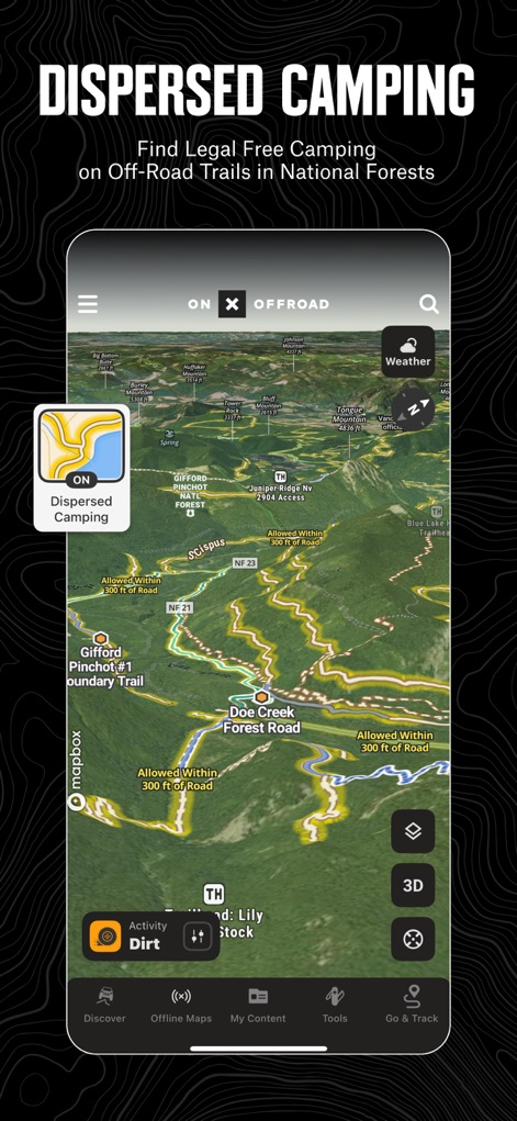
분산형 캠핑 및 중요 지점 안내
이 도구는 국유림 내 합법적인 분산형 캠핑 장소와 더불어 트레일 입구, 주유소 등 오프로드에 필요한 다양한 관심 지점을 찾아주어 여행 계획을 돕습니다.
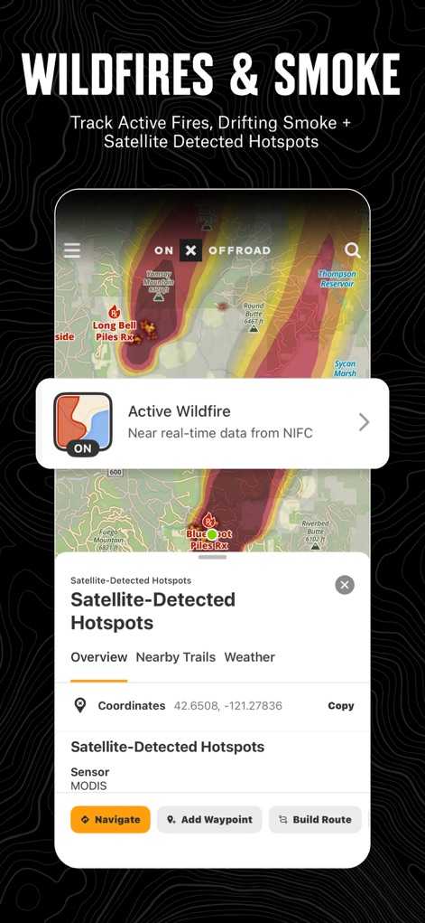
실시간 환경 및 통신망 정보
이 앱은 NOAA 대기 연기 예보와 이동통신사별 셀 서비스 커버리지 정보를 제공하여 안전하고 연결된 탐험을 가능하게 합니다.
자주 묻는 질문
에 대해 알아야 할 모든 것 onX Offroad: Trail Maps & GPS
What does the onX Offroad app do?
The onX Offroad app provides off-road trail maps, GPS mapping, and compass navigation. It helps users discover trails, identify open areas, and explore new routes for various off-road activities.
Can I filter trails by vehicle type in onX Offroad?
Yes, onX Offroad allows users to filter trails by accessibility for 4x4, SxS, dirt bikes, moto, ATV/Quads, Overland, and snowmobiles.
How does onX Offroad help find dispersed camping?
onX Offroad features a Motorized Dispersed Camping Layer using USFS verified data. It identifies legal, free off-grid camping areas in National Forests.
Does onX Offroad show private property lines?
Yes, onX Offroad provides property lines and private landowner information across the nation. This feature is limited by membership.
Can I see cell service coverage with onX Offroad?
Yes, onX Offroad includes AT&T, Verizon, and T-Mobile coverage maps. This helps users know where they will have cell service while off-roading.
Does onX Offroad offer offline maps?
Yes, onX Offroad allows users to save Offline Maps to their phone or tablet. This enables navigation without cell service, retaining interactive land and trail data.
Is onX Offroad compatible with Apple CarPlay?
Yes, onX Offroad offers turn-by-turn navigation and can sync with Apple CarPlay for in-vehicle display and control.
What map layers are available in the onX Offroad app?
onX Offroad offers various map layers, including weather, land boundaries, cell service, active wildfires, and wildfire smoke data.
Does onX Offroad help monitor wildfires?
Yes, onX Offroad monitors wildfires and drifting smoke with data from the NIFC and NOAA. This feature helps users anticipate poor air quality.
What features do onX Offroad memberships include?
Memberships include access to over 650K miles of motorized trails, 852M acres of public land, 24K topographic and 3D maps, and the ability to save Offline Maps.
Does onX Offroad offer a free trial?
Yes, onX Offroad offers a free trial when users install the app. This allows experience with its premium off-roading tools.
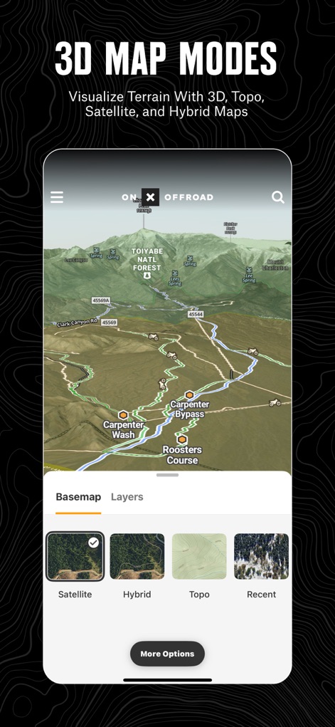
Does onX Offroad support 3D map views?
Yes, onX Offroad supports 3D map modes for visualizing terrain. Users can choose from 3D, topo, satellite, or hybrid map imagery.
Can onX Offroad display recent satellite imagery?
Yes, onX Offroad provides recent imagery to check trail and terrain conditions via satellite. Users can select imagery by date.
Does onX Offroad identify public lands?
Yes, onX Offroad identifies various public lands, including National Forests, BLM land, and National Parks. This helps users navigate and understand land ownership.
What navigation features does onX Offroad provide?
onX Offroad offers GPS navigation, turn-by-turn directions with voice commands, a route builder, and trip tracking for distance, location, speed, or elevation.
다음 스크린샷과 설명은 앱의 공식 스토어 목록에서 직접 가져온 것이며 앱 개발자의 자산입니다.
앱 스토어
스크린샷


설명
Download
비슷한 앱
유사한 기능과 사용자 경험을 가진 앱

Detecht - Motorcycle App & GPS
Detecht Technologies AB

REVER - Motorcycle GPS & Rides
Rever, LLC

NYSSA Snowmobile Trails
Mapgears Inc.

Scenic Motorcycle Navigation
Applified Life Ltd.

Trails Offroad: Offline Maps
TRAILS OFFROAD LLC

Overland Bound One: Maps & GPS
Overland Bound Inc

Stegra.io - Motorcycle GPS
Stegraio AB

GoSnowmobiling NB
Mapgears Inc.

Lost Riders
Lost Riders, LLC
이 페이지는 앱이나 개발자의 공식 페이지가 아니며, 정보 제공 및 논평을 목적으로 작성된 독립 편집 간행물입니다. 명시적으로 달리 언급되지 않는 한, 해당 앱이나 개발자는 MWM, Apple, Google Play, 앱 퍼블리셔 또는 앱 개발자와 제휴, 보증, 후원, 승인 또는 공식적으로 연결되어 있지 않으며, 이 페이지의 어떤 내용도 해당 앱이 MWM의 서비스를 사용하여 개발되었음을 의미하지 않습니다. 모든 상표, 로고, 스크린샷 및 기타 콘텐츠는 해당 소유자의 자산입니다.