이 페이지는 앱이나 개발자의 공식 페이지가 아니며, 정보 제공 및 논평을 목적으로 작성된 독립 편집 간행물입니다. 명시적으로 달리 언급되지 않는 한, 해당 앱이나 개발자는 MWM, Apple, Google Play, 앱 퍼블리셔 또는 앱 개발자와 제휴, 보증, 후원, 승인 또는 공식적으로 연결되어 있지 않으며, 이 페이지의 어떤 내용도 해당 앱이 MWM의 서비스를 사용하여 개발되었음을 의미하지 않습니다. 모든 상표, 로고, 스크린샷 및 기타 콘텐츠는 해당 소유자의 자산입니다.

pathRecorder - come back
완벽한 자신감으로 깊은 숲이나 탁 트인 바다를 탐색하세요. 인터넷 연결 없이 정밀한 경로를 기록하고, 중요한 경유지를 표시하고, 집으로 돌아가는 길을 찾으세요. 견고한 신뢰성을 요구하는 등산객, 항해사, 오프로드 운전자를 위해 제작되었습니다.
다운로드
21K+사용자 평점
총 평가 수
0개발사
카테고리
Navigation지원 언어
1최신 버전
3.3크기
5.8 MB출시일
2012년 4월 10일자립적인 모험가를 위한 정밀 내비게이션
이동 통신 데이터가 실패하는 환경을 위해 설계된 pathRecorder는 오프 그리드로 모험을 떠나는 사람들을 위해 안정적인 오프라인 추적, 정밀한 경유지, 원시 데이터 내보내기를 제공합니다.
안전한 귀가 보장
'돌아오기' 기능을 사용하여 시작 지점이나 저장된 좌표로 돌아가세요. 인터넷 연결이 필요하지 않습니다.
기술 데이터 휴대성
고정밀 CSV 로그로 여정을 기록하세요. 고도, 속도, 코스 데이터를 Excel 또는 Numbers로 내보내 전문적인 여행 후 분석을 수행하세요.
다음 스크린샷과 설명은 앱의 공식 스토어 목록에서 직접 가져온 것이며 앱 개발자의 자산입니다.
앱 스토어
스크린샷
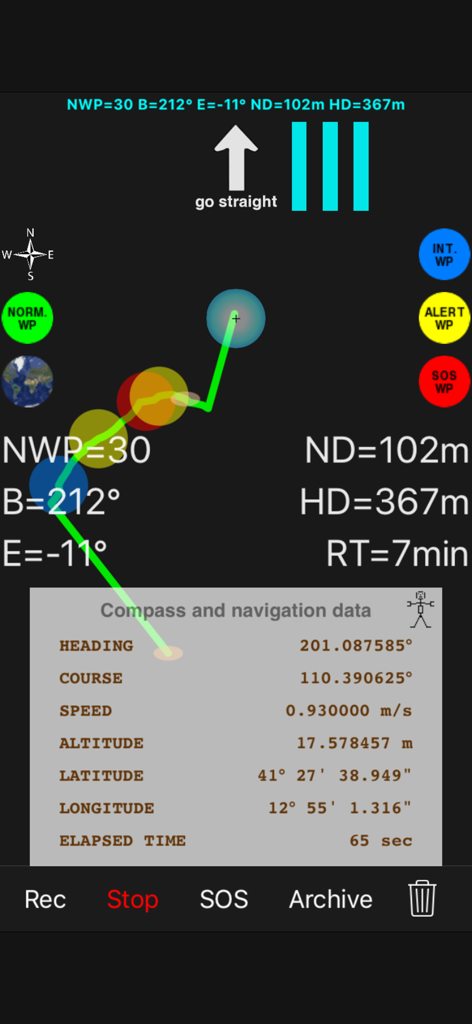
하이라이트된 GPS 데이터와 웨이포인트가 있는 기록된 경로를 보여주는 고대비 기술 내비게이션 인터페이스.
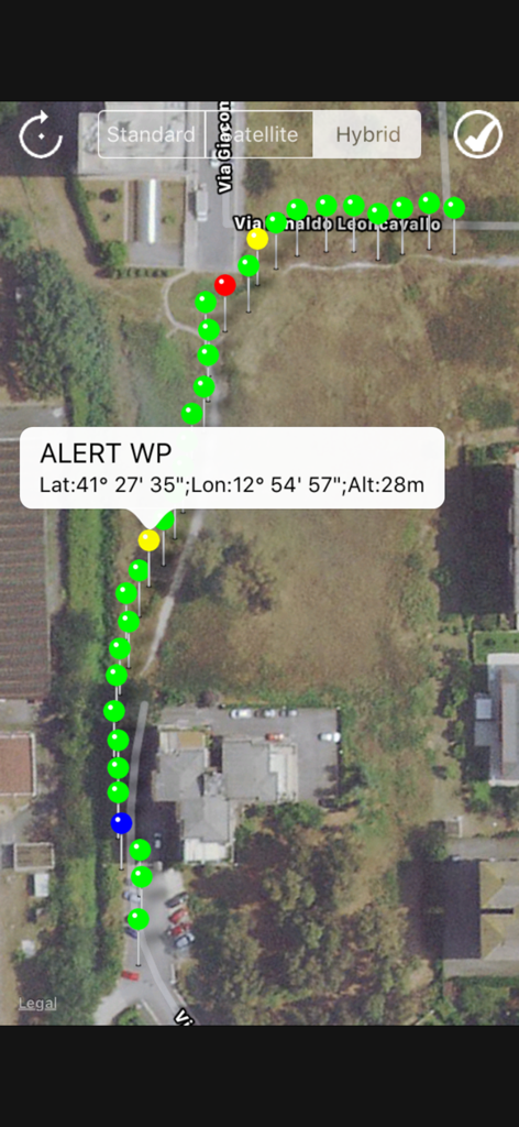
색상으로 구분된 웨이포인트의 경로를 보여주는 위성 지도 보기와 위도 및 경도를 포함한 특정 경고 좌표가 있는 팝업.
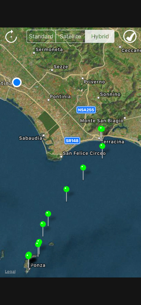
해상 내비게이션을 위한 녹색 웨이포인트가 있는 기록된 경로를 보여주는 하이브리드 지도.
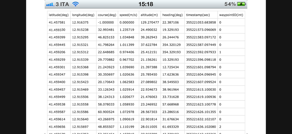
좌표 및 속도를 포함한 기록된 GPS 내비게이션 데이터 스프레드시트 보기.
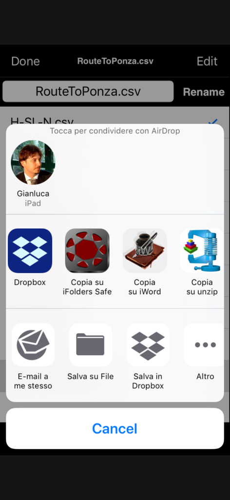
데이터 분석을 위해 iOS 공유 메뉴를 통해 CSV 파일로 기록된 경로 공유.
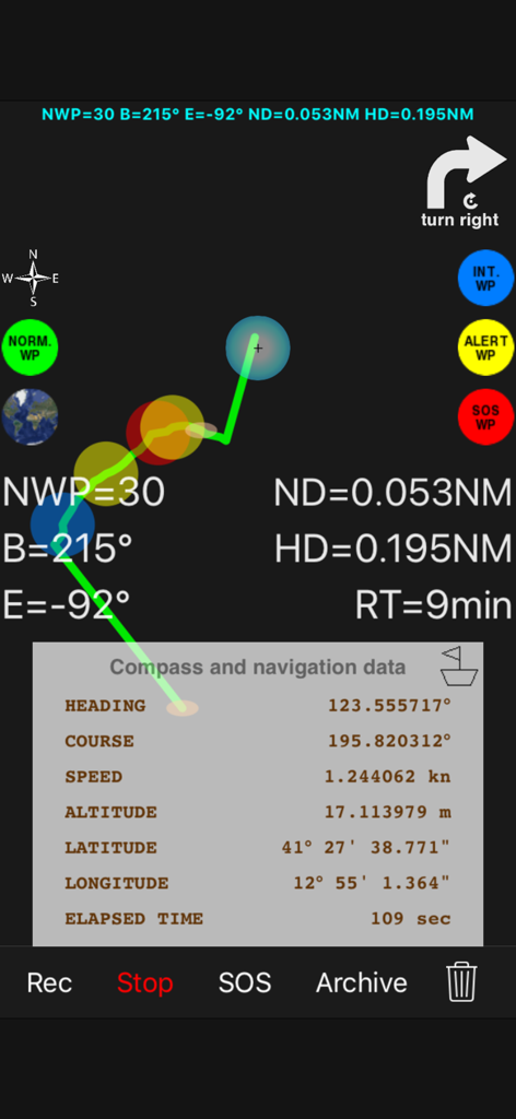
경로 및 위도, 경도를 포함한 GPS 데이터를 포함한 고대비 내비게이션 화면.
설명
Download
비슷한 앱
같은 카테고리의 상위 앱

Google Maps
Google LLC

Waze Navigation & Live Traffic
waze

AMap Global
AutoNavi Information Technology Co. Ltd.

百度地图-路线规划,出行必备
Beijing Baidu Netcom Science & Technology Co.,Ltd

Moovit: Bus & Transit Tracker
Moovit App Global LTD

Transit • Subway & Bus Times
9280-0366 Quebec inc.

ParkMobile: Park. Pay. Go.
Parkmobile USA, Inc

腾讯地图-路线规划,导航地铁打车出行
Shenzhen Tencent Computer Systems Company Limited

Île-de-France Mobilités
Ile de France Mobilites
이 페이지는 앱이나 개발자의 공식 페이지가 아니며, 정보 제공 및 논평을 목적으로 작성된 독립 편집 간행물입니다. 명시적으로 달리 언급되지 않는 한, 해당 앱이나 개발자는 MWM, Apple, Google Play, 앱 퍼블리셔 또는 앱 개발자와 제휴, 보증, 후원, 승인 또는 공식적으로 연결되어 있지 않으며, 이 페이지의 어떤 내용도 해당 앱이 MWM의 서비스를 사용하여 개발되었음을 의미하지 않습니다. 모든 상표, 로고, 스크린샷 및 기타 콘텐츠는 해당 소유자의 자산입니다.