이 페이지는 앱이나 개발자의 공식 페이지가 아니며, 정보 제공 및 논평을 목적으로 작성된 독립 편집 간행물입니다. 명시적으로 달리 언급되지 않는 한, 해당 앱이나 개발자는 MWM, Apple, Google Play, 앱 퍼블리셔 또는 앱 개발자와 제휴, 보증, 후원, 승인 또는 공식적으로 연결되어 있지 않으며, 이 페이지의 어떤 내용도 해당 앱이 MWM의 서비스를 사용하여 개발되었음을 의미하지 않습니다. 모든 상표, 로고, 스크린샷 및 기타 콘텐츠는 해당 소유자의 자산입니다.

Photographer's Ephemeris 3D
이 앱은 당신이 선택한 어떤 풍경이든, 태양, 달, 은하수를 조종하는 신이 되는 경험을 제공합니다.
다운로드
10k+사용자 평점
총 평가 수
675개발사
카테고리
Photo & Video지원 언어
3최신 버전
1.5.2크기
38.6 MB출시일
2017년 6월 27일야외 및 야간 사진가를 위한 고급 촬영 계획 도구 분석
Photographer's Ephemeris 3D 기능 분석
정확한 3D 자연광 및 천체 시뮬레이션
사용자는 특정 위치에서 일출, 일몰, 월출, 월몰, 은하수 위치를 포함한 자연광이 지형에 어떻게 드리울지 정확하게 예측하고 시각화할 수 있습니다. 이는 풍경 및 야간 사진 촬영 계획에 필수적입니다.
정밀한 촬영 계획 도구
이 앱은 태양, 달, 은하 중심의 시계열 및 뜨고 지는 시간, 통과 이벤트와 같은 상세한 정보를 제공하여 사용자가 촬영 일정을 최적화하고 특정 광학 현상을 포착할 수 있도록 돕습니다.
현실적인 3D 지형 및 그림자 디테일
고해상도 지도 타일과 GPU 가속 지형 로딩을 통해 현실적인 3D 환경을 제공하며, '향상 모드'에서는 최대 지형 및 그림자 디테일을 구현하여 사용자가 현장의 빛과 그림자를 더욱 정확하게 분석할 수 있습니다.
유연한 시점 제어 및 탐색
이 도구는 사용자가 장면에 부드럽게 접근하거나 초점 거리 등가물로 확대할 수 있게 하며, 카메라 피치, 방위, 고도를 직접 제어할 수 있는 기능을 제공하여 다양한 각도에서 빛의 흐름을 탐색할 수 있도록 돕습니다.
정확한 달 위상 렌더링
이 앱은 장면에 정확한 달 위상을 렌더링하여, 사용자가 달의 밝기 및 모양이 야간 촬영에 미칠 영향을 예측하고 계획에 반영할 수 있도록 합니다.
위치 검색 및 좌표 입력 기능
사용자는 위치를 검색하거나 십진수/DMS 좌표를 직접 입력할 수 있으며, 기존 TPE 데이터베이스와 공유하여 효율적인 위치 관리를 할 수 있습니다.
다중 지도 핀 및 상태 저장
이 앱은 여러 지도 핀을 설정하고 각 핀의 상태(예: 특정 시간, 카메라 설정)를 세션 간에 기억하여 사용자가 여러 잠재적 촬영 위치나 시간대를 효율적으로 비교하고 관리할 수 있도록 지원합니다.
사용자 친화적인 인터페이스 개선
향상된 제어 기능과 재작업된 두 손가락 제스처를 통해 사용자는 더욱 정밀하게 탐색하고 부드러운 경험을 할 수 있습니다.
다음 스크린샷과 설명은 앱의 공식 스토어 목록에서 직접 가져온 것이며 앱 개발자의 자산입니다.
앱 스토어
스크린샷
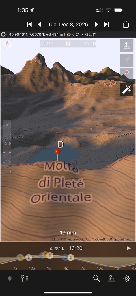
이 앱은 정확한 3D 지형 위에 사실적인 햇빛과 그림자를 시뮬레이션하여 특정 시간과 날짜에 따른 광원의 변화를 예측합니다.
지형별 광원 시뮬레이션
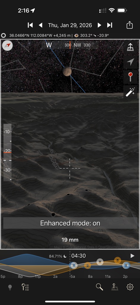
사용자는 향상된 모드를 통해 상세한 3D 지형과 달, 별을 포함한 야간 하늘을 정밀하게 시뮬레이션하여 최적의 촬영 환경을 계획할 수 있습니다.
야간 촬영 최적화
이 도구는 상세한 등고선과 동적으로 변화하는 그림자를 3D 지형에 투영하여 사용자가 특정 위치의 광원 조건을 정확하게 파악하도록 돕습니다.
정밀한 지형 분석
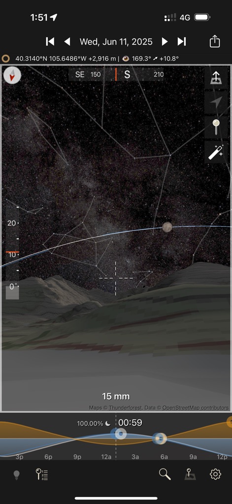
이 앱은 은하수와 별자리를 포함한 밤하늘의 모습을 정확하게 시뮬레이션하며, 달의 위상과 밝기를 실시간으로 조정하여 야간 촬영 계획을 지원합니다.
은하수 예측 및 달 위상
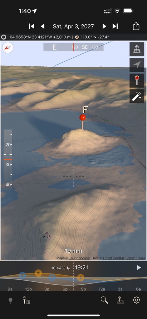
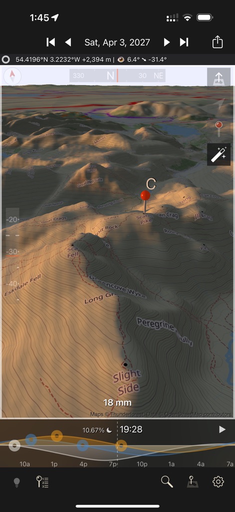
사용자는 물이 포함된 3D 지형을 탐색하고, 여러 개의 맵 핀을 활용하여 촬영 포인트를 저장하고 해당 위치의 빛 조건을 쉽게 파악할 수 있습니다.
수자원 통합 지형
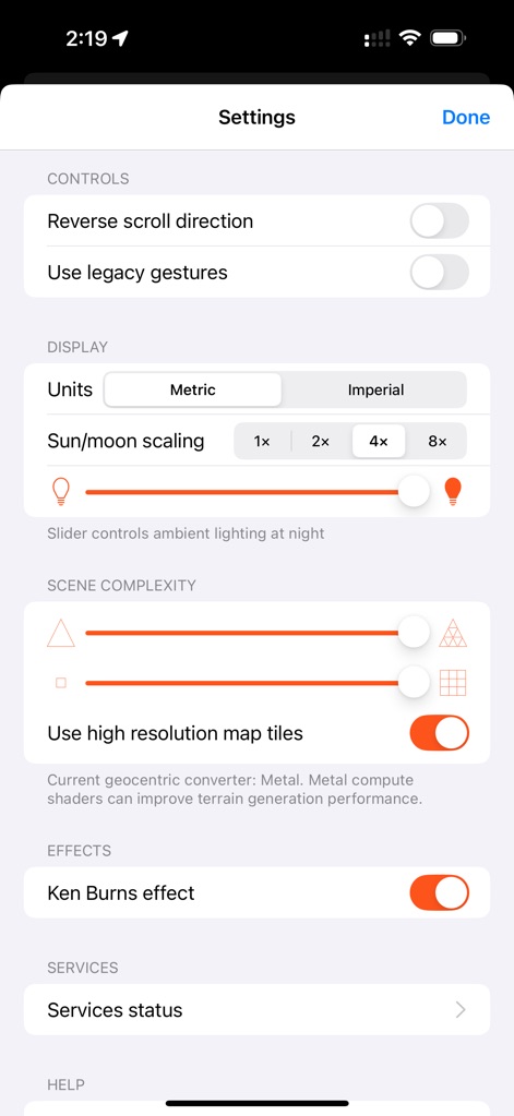
이 앱은 사용자가 단위 설정과 같은 기본 옵션부터 고해상도 지도 타일 활성화에 이르기까지 다양한 시각적 및 기능적 설정을 통해 경험을 개인화할 수 있도록 합니다.
맞춤형 설정 및 제어
설명
Download
비슷한 앱
같은 카테고리의 상위 앱

CapCut: Photo & Video Editor
BYTEDANCE PTE. LTD.

Instagram, Inc.

YouTube
Google LLC

Canva: AI Photo & Video Editor
Canva Pty Ltd

Snapchat
Snap, Inc.

快手
Beijing Kwai Technology Co., Ltd.

Edits: Video Editor
Instagram, Inc.

Meitu- AI Photo & Video Editor
Xiamen Meitu Technology Co., Ltd.

Google Photos: Backup & Edit
Google LLC
이 페이지는 앱이나 개발자의 공식 페이지가 아니며, 정보 제공 및 논평을 목적으로 작성된 독립 편집 간행물입니다. 명시적으로 달리 언급되지 않는 한, 해당 앱이나 개발자는 MWM, Apple, Google Play, 앱 퍼블리셔 또는 앱 개발자와 제휴, 보증, 후원, 승인 또는 공식적으로 연결되어 있지 않으며, 이 페이지의 어떤 내용도 해당 앱이 MWM의 서비스를 사용하여 개발되었음을 의미하지 않습니다. 모든 상표, 로고, 스크린샷 및 기타 콘텐츠는 해당 소유자의 자산입니다.