이 페이지는 앱이나 개발자의 공식 페이지가 아니며, 정보 제공 및 논평을 목적으로 작성된 독립 편집 간행물입니다. 명시적으로 달리 언급되지 않는 한, 해당 앱이나 개발자는 MWM, Apple, Google Play, 앱 퍼블리셔 또는 앱 개발자와 제휴, 보증, 후원, 승인 또는 공식적으로 연결되어 있지 않으며, 이 페이지의 어떤 내용도 해당 앱이 MWM의 서비스를 사용하여 개발되었음을 의미하지 않습니다. 모든 상표, 로고, 스크린샷 및 기타 콘텐츠는 해당 소유자의 자산입니다.

Radius on Map + : draw circle
서비스 영역, 부동산, 현장 운영을 위한 필수 도구입니다. UTM/MGRS 지원으로 여러 반경을 정의하고, KML 파일을 내보내고, URL을 통해 결과를 공유하세요. 모두 일회성 구매로 가능하며 구독이 없습니다.
다운로드
15K+사용자 평점
총 평가 수
0개발사
카테고리
Utilities지원 언어
36최신 버전
2.9크기
5.0 MB출시일
2015년 5월 31일정밀한 반경 지도를 위한 전문가급 도구
기본 지도 이상의 기능을 요구하는 전문가를 위해 설계된 고정밀 도구 키트를 사용하여 경계를 정의하고, 서비스 영역을 계산하고, 공간 데이터를 내보내세요.
기술적 정밀도 및 좌표
UTM 및 MGRS와 같은 전문가용 좌표 형식을 사용하고, KML/KMZ 파일을 사용하여 모바일 장치와 Google Earth 간의 연동을 지원합니다.
즉시 공유 가능한 인사이트
고객 및 팀에게 서비스 영역 또는 프로젝트 경계가 어디에 있는지 정확히 보여주기 위해 고유한 URL을 생성하거나 사용자 정의 다각형을 내보냅니다.
다음 스크린샷과 설명은 앱의 공식 스토어 목록에서 직접 가져온 것이며 앱 개발자의 자산입니다.
앱 스토어
스크린샷
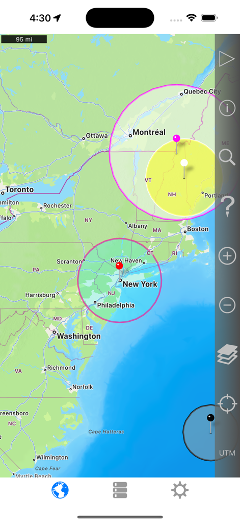
미국 북동부 지도를 표시하는 지도 상에 여러 원형 거리 영역을 보여주는 지도상의 반경 앱 인터페이스.
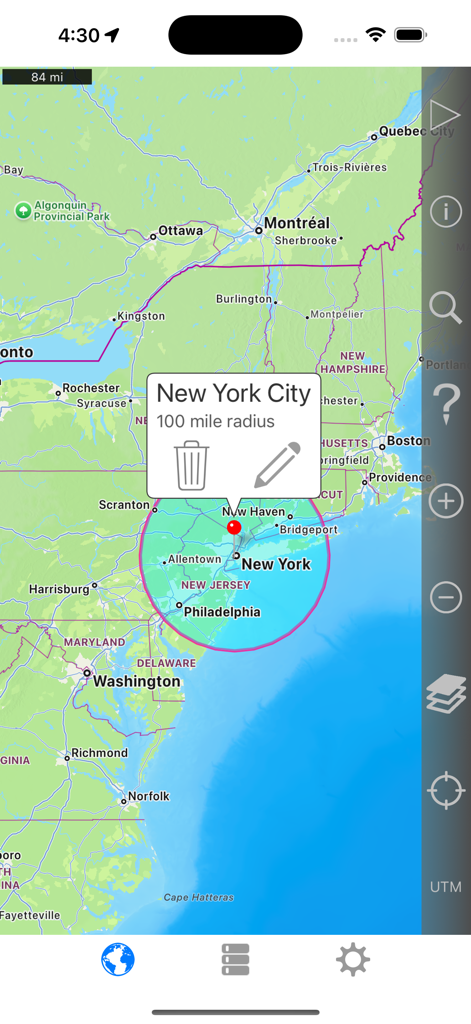
지도상의 반경 앱 인터페이스와 함께 뉴욕시 중심 100마일 반경 원을 보여주는 지도.
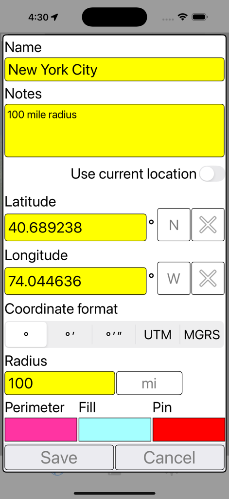
좌표를 사용하여 뉴욕시 주변 100마일 반경을 정의하는 지도상의 반경 앱 설정 화면
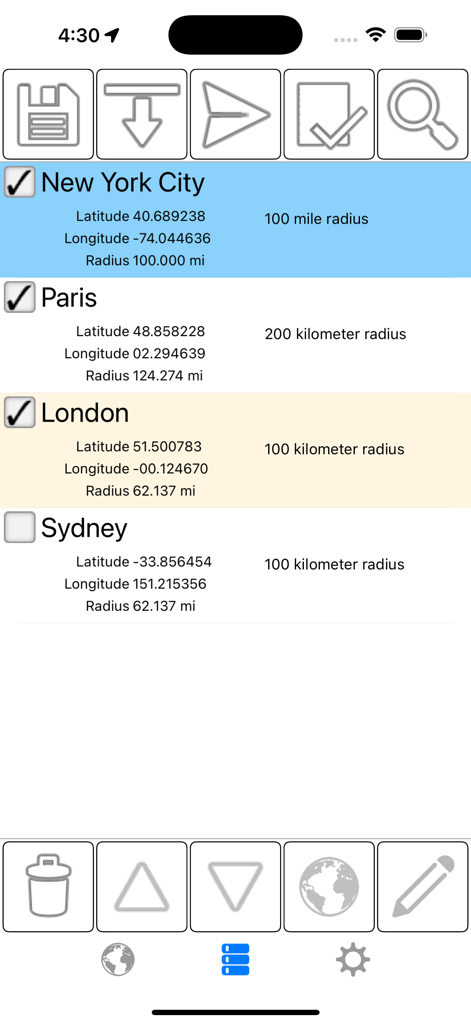
좌표 및 거리 측정값을 보여주는 뉴욕 및 파리와 같은 도시의 저장된 지리적 반경 목록
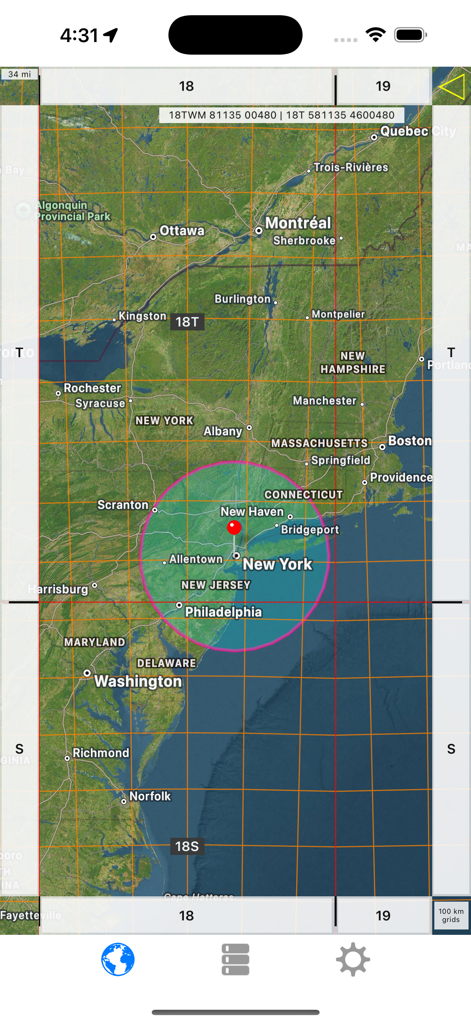
뉴욕 상공에 분홍색 원과 기술 그리드 선을 보여주는 지도상의 반경 앱 스크린샷
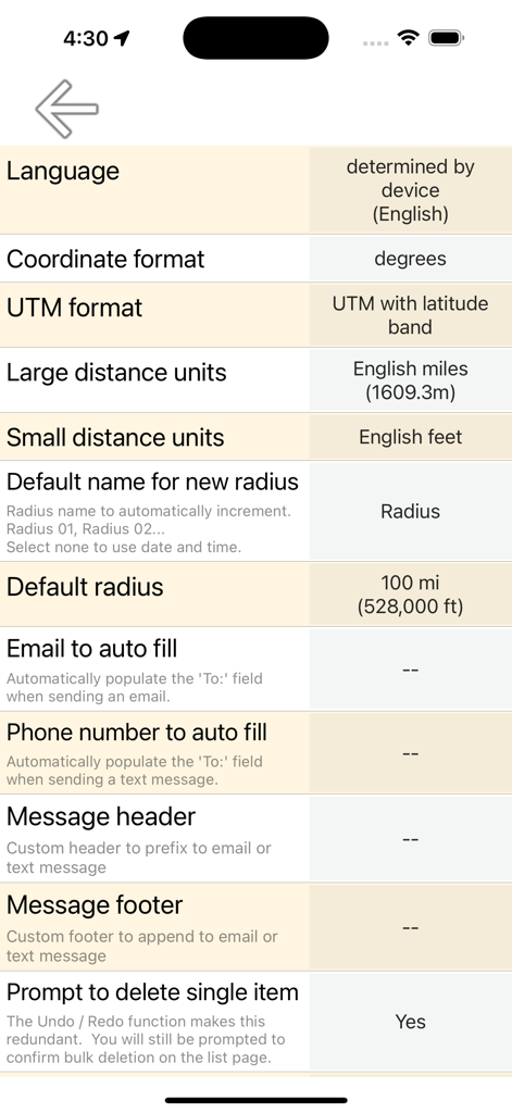
좌표 형식 및 거리 단위 옵션을 보여주는 지도상의 반경 앱 설정 화면
설명
Download
비슷한 앱
같은 카테고리의 상위 앱

Google LLC

Google Chrome
Google LLC

中国移动(手机营业厅)
China Mobile Online Services Co., Ltd.

Google Authenticator
Google LLC

CNH do Brasil
Servicos e Informacoes do Brasil

Cleanup: Phone Storage Cleaner
DEEP FLOW SOFTWARE SERVICES - FZCO

gov.br
Servicos e Informacoes do Brasil

中国电信-全国统一官方服务平台
CHINA TELECOM Corporation Ltd.

Microsoft Edge: AI Browser
Microsoft Corporation
이 페이지는 앱이나 개발자의 공식 페이지가 아니며, 정보 제공 및 논평을 목적으로 작성된 독립 편집 간행물입니다. 명시적으로 달리 언급되지 않는 한, 해당 앱이나 개발자는 MWM, Apple, Google Play, 앱 퍼블리셔 또는 앱 개발자와 제휴, 보증, 후원, 승인 또는 공식적으로 연결되어 있지 않으며, 이 페이지의 어떤 내용도 해당 앱이 MWM의 서비스를 사용하여 개발되었음을 의미하지 않습니다. 모든 상표, 로고, 스크린샷 및 기타 콘텐츠는 해당 소유자의 자산입니다.