이 페이지는 앱이나 개발자의 공식 페이지가 아니며, 정보 제공 및 논평을 목적으로 작성된 독립 편집 간행물입니다. 명시적으로 달리 언급되지 않는 한, 해당 앱이나 개발자는 MWM, Apple, Google Play, 앱 퍼블리셔 또는 앱 개발자와 제휴, 보증, 후원, 승인 또는 공식적으로 연결되어 있지 않으며, 이 페이지의 어떤 내용도 해당 앱이 MWM의 서비스를 사용하여 개발되었음을 의미하지 않습니다. 모든 상표, 로고, 스크린샷 및 기타 콘텐츠는 해당 소유자의 자산입니다.
다운로드
25k+사용자 평점
총 평가 수
9개발사
카테고리
Navigation지원 언어
1최신 버전
1.0.2크기
85.9 MB출시일
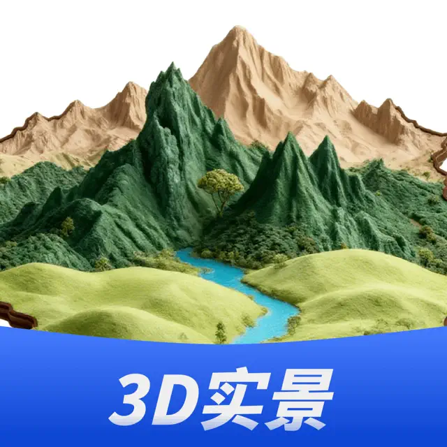
2026년 1월 30일지리 전문가를 위한 고급 3D 지형 탐색 및 분석 도구
三维山水全景地图 기능 분석
실시간 3D 지형 탐색
사용자가 3D 시야로 산맥의 추세, 수계 분포 및 경사 고도차를 직관적으로 파악하게 해줍니다.
효율적인 지리 분석 도구
사용자가 지리적 패턴을 식별하고, 데이터를 해석하며, 정보에 입각한 결정을 내리는 데 필요한 기능을 제공합니다.
직관적인 인터랙티브 조작
복잡한 지리 정보를 접근하고 이해하는 과정을 단순화하여 사용자 경험을 향상시킵니다.
다양한 지도 소스 통합
특정 지역에 대한 포괄적인 정보를 제공하여 심층적인 분석과 연구를 가능하게 합니다.
방대한 지리 데이터 제공
교육, 연구, 계획 또는 가상 탐험 등 다양한 목적으로 풍부하고 상세한 데이터 기반을 제공합니다.
원격 상세 관측 기능
현장 방문의 필요성을 줄여 시간과 자원을 절약하면서도 지리적 환경에 대한 깊은 이해를 가능하게 합니다.
다음 스크린샷과 설명은 앱의 공식 스토어 목록에서 직접 가져온 것이며 앱 개발자의 자산입니다.
앱 스토어
스크린샷
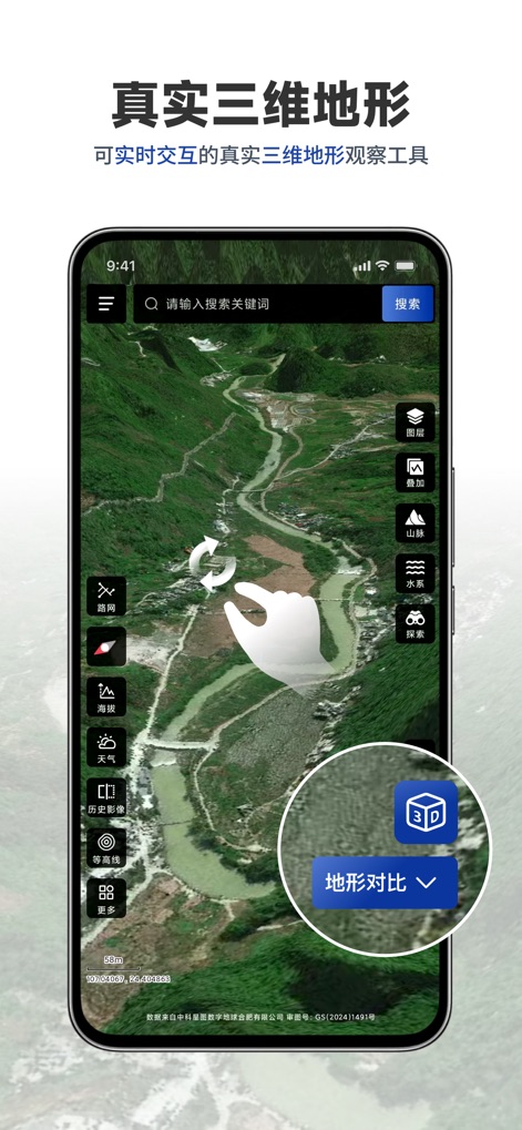
이 앱은 실시간 인터랙티브 3D 뷰를 제공하여 사용자가 산맥의 흐름과 수계 분포를 직관적으로 파악하고, 강력한 지형 비교 기능을 통해 다양한 지형 변화를 분석할 수 있습니다.
실시간 3D 지형 탐색
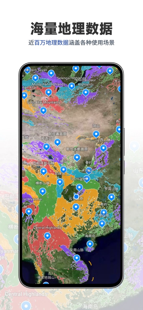
이 도구는 아시아 대륙을 포함한 광범위한 지역에 걸쳐 거의 백만 개에 달하는 방대한 지리 데이터를 제공하며, 다양한 색상으로 구분된 지형 구분과 명확한 산맥 및 고원 표시를 통해 지리적 특징을 명확히 보여줍니다.
방대한 지리 데이터
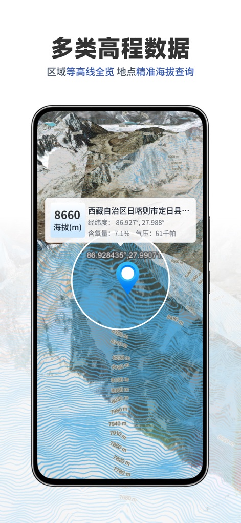
사용자는 이 앱에서 특정 지점의 정밀한 고도 정보를 8660m와 같은 수치로 즉시 확인할 수 있으며, 상세한 등고선 지도를 통해 주변 지형의 미세한 변화를 시각적으로 분석할 수 있습니다.
정밀한 고도 정보
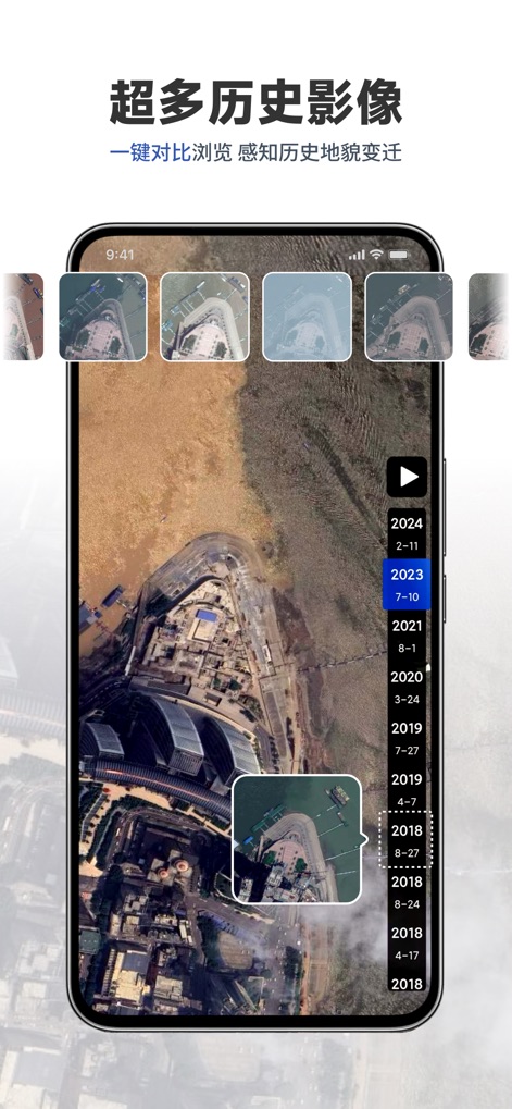
이 도구는 2018년부터 2024년까지의 다양한 시점의 풍부한 역사적 위성 이미지를 제공하여, 사용자가 시간 흐름에 따른 지형 변화를 한눈에 파악하고 한 번의 클릭으로 이전 모습과 현재 모습을 손쉽게 비교할 수 있습니다.
과거 지형 변화 기록
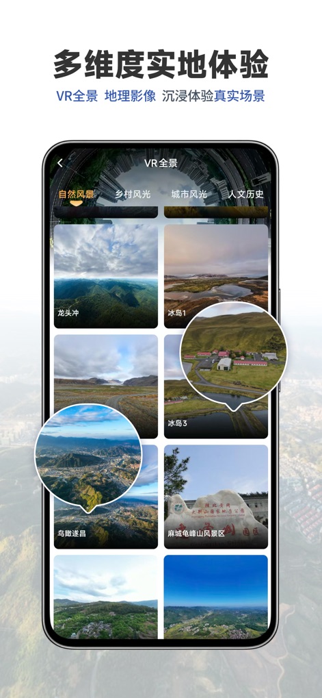
이 앱은 자연 풍경부터 도시 풍경에 이르는 다채로운 VR 파노라마 이미지를 통해 사용자를 몰입형 가상 탐험으로 안내하며, 다양한 카테고리의 실제와 같은 장면을 통해 생생한 현장감을 제공합니다.
몰입형 VR 파노라마
설명
Download
비슷한 앱
같은 카테고리의 상위 앱

Google Maps
Google LLC

AMap Global
AutoNavi Information Technology Co. Ltd.

Waze Navigation & Live Traffic
waze

百度地图-路线规划,出行必备
Beijing Baidu Netcom Science & Technology Co.,Ltd

Moovit: Bus & Transit Tracker
Moovit App Global LTD

Transit • Subway & Bus Times
9280-0366 Quebec inc.

ParkMobile: Park. Pay. Go.
Parkmobile USA, Inc

腾讯地图-路线规划,导航地铁打车出行
Shenzhen Tencent Computer Systems Company Limited

MapXplorer: Map Radar Navigate
GOLDLAB APPLICATIONS YAZILIM VE BILISIM ANONIM SIRKETI
이 페이지는 앱이나 개발자의 공식 페이지가 아니며, 정보 제공 및 논평을 목적으로 작성된 독립 편집 간행물입니다. 명시적으로 달리 언급되지 않는 한, 해당 앱이나 개발자는 MWM, Apple, Google Play, 앱 퍼블리셔 또는 앱 개발자와 제휴, 보증, 후원, 승인 또는 공식적으로 연결되어 있지 않으며, 이 페이지의 어떤 내용도 해당 앱이 MWM의 서비스를 사용하여 개발되었음을 의미하지 않습니다. 모든 상표, 로고, 스크린샷 및 기타 콘텐츠는 해당 소유자의 자산입니다.