이 페이지는 앱이나 개발자의 공식 페이지가 아니며, 정보 제공 및 논평을 목적으로 작성된 독립 편집 간행물입니다. 명시적으로 달리 언급되지 않는 한, 해당 앱이나 개발자는 MWM, Apple, Google Play, 앱 퍼블리셔 또는 앱 개발자와 제휴, 보증, 후원, 승인 또는 공식적으로 연결되어 있지 않으며, 이 페이지의 어떤 내용도 해당 앱이 MWM의 서비스를 사용하여 개발되었음을 의미하지 않습니다. 모든 상표, 로고, 스크린샷 및 기타 콘텐츠는 해당 소유자의 자산입니다.

TerraCam: GPS Satellite
당신은 더 이상 길을 잃지 않습니다. 이 앱은 당신의 스마트폰을 전 세계를 감시하는 제어 센터로 전환시킵니다.
다운로드
1M+사용자 평점
총 평가 수
2.0K개발사
카테고리
Travel지원 언어
17최신 버전
1.1.0크기
102.1 MB출시일
2025년 9월 16일여행자, 사진작가, 모험가를 위한 통합 탐색 및 기록 도구
TerraCam: GPS Satellite 앱 분석
GPS 카메라
이 앱은 사진에 위치, 날짜, 시간 정보를 자동으로 태그하여 여행 기록을 풍부하게 만듭니다.
지구 3D 지도
이 도구는 사용자가 전 세계를 대화형 3D 지도로 탐색하며 지역에 대한 깊이 있는 이해를 얻을 수 있게 해줍니다.
유명 장소 탐색
이 앱은 전 세계의 유명한 랜드마크와 관광 명소를 쉽게 찾고 탐험할 수 있도록 지원합니다.
실시간 교통 지도
사용자는 실시간 교통 상황을 확인하여 여행 경로를 효율적으로 계획하고 시간 지연을 피할 수 있습니다.
정확한 나침반
이 도구는 사용자가 정확한 방향을 쉽게 파악하여 길을 잃지 않고 탐험할 수 있도록 돕습니다.
360도 뷰
이 앱은 파노라마 이미지를 통해 광범위한 시야를 제공하여 사용자가 특정 장소를 미리 경험할 수 있게 합니다.
실시간 카메라
이 앱은 사용자가 다양한 지역의 실시간 공공 카메라를 통해 현재 상황을 시각적으로 확인할 수 있도록 합니다.
대기질 정보
이 도구는 사용자가 특정 지역의 대기질 상태를 즉시 확인하여 야외 활동 계획에 참고할 수 있도록 합니다.
자주 묻는 질문
에 대해 알아야 할 모든 것 TerraCam: GPS Satellite
What is TerraCam: GPS Satellite?
TerraCam: GPS Satellite is an application that combines location tagging with map and travel tools. It allows users to capture photos with GPS details, explore interactive maps, check traffic, and access navigation features.
What are the main features of TerraCam: GPS Satellite?
TerraCam: GPS Satellite offers GPS Camera, Live Cameras, 360 View, Earth 3D Map, Traffic Map, Famous Places, Compass, Air Quality, and World Clock. These provide comprehensive navigation and exploration tools.
Can TerraCam: GPS Satellite capture photos with location data?
Yes, TerraCam: GPS Satellite includes a GPS Camera feature. It captures photos embedded with location, date, and time details, ensuring your memories are accurately geotagged.
Does TerraCam: GPS Satellite offer a 3D view of Earth?
Yes, TerraCam: GPS Satellite features an Earth 3D Map. This allows users to navigate the globe with interactive three-dimensional views, enhancing exploration.
How can I check traffic conditions using TerraCam: GPS Satellite?
TerraCam: GPS Satellite provides a Traffic Map feature to keep you updated. It displays real-time traffic conditions, assisting you with navigation and travel planning.
Does TerraCam: GPS Satellite include a compass?
Yes, TerraCam: GPS Satellite integrates a Compass feature. This tool provides accurate directions, making it easy to orient yourself during travel or exploration.
Where can I find the Privacy Policy for TerraCam: GPS Satellite?
The Privacy Policy for TerraCam: GPS Satellite is available at https://sites.google.com/view/terra-cam-gps/privacy-policy. This document outlines how the app handles user data.
Can TerraCam: GPS Satellite show live camera feeds?
Yes, TerraCam: GPS Satellite includes a Live Cameras feature. It allows users to view selected public cameras from various locations around the world.
What types of map views are available in TerraCam: GPS Satellite?
TerraCam: GPS Satellite offers various map views, including Default, Terrain, Satellite, and Night. Users can select their preferred map style for navigation and exploration.
다음 스크린샷과 설명은 앱의 공식 스토어 목록에서 직접 가져온 것이며 앱 개발자의 자산입니다.
앱 스토어
스크린샷

이 앱의 직관적인 메인 인터페이스는 라이브 스트림 기능과 함께 3D 지구 보기를 통해 다양한 탐험 옵션을 제공합니다.
주요 기능 한눈에
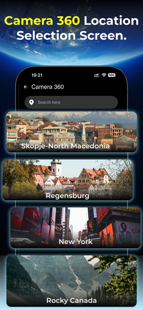
사용자는 360도 카메라 기능으로 전 세계를 탐험하며, 검색 바를 통해 특정 장소를 찾거나 스코페, 뉴욕과 같은 다양한 글로벌 목적지를 선택할 수 있습니다.
360도 카메라 선택
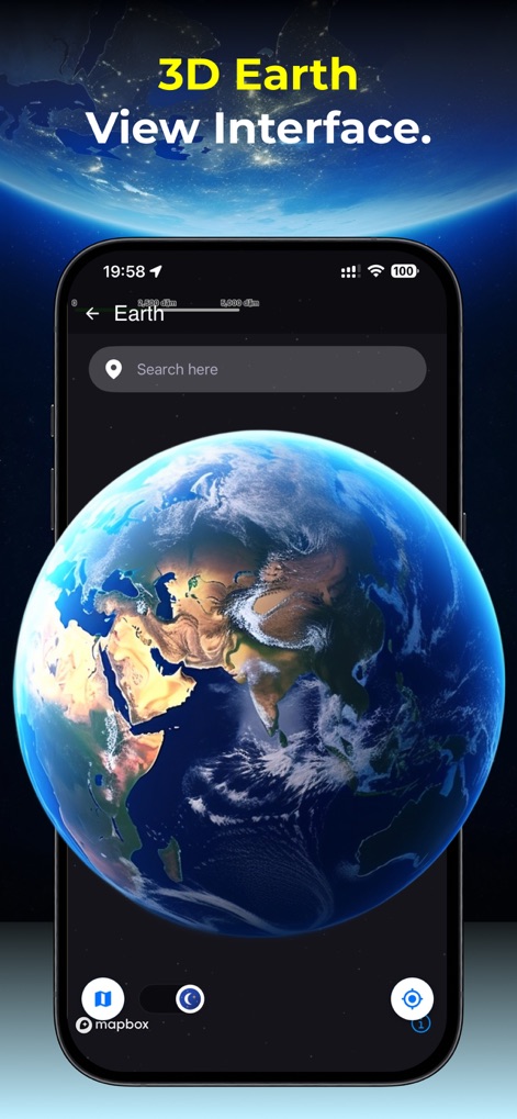
이 앱은 실시간으로 회전하는 인터랙티브 3D 지구를 제공하여 사용자가 전 세계를 탐색하고, 상단 검색 바를 통해 특정 위치를 손쉽게 찾을 수 있도록 합니다.
생생한 3D 지구
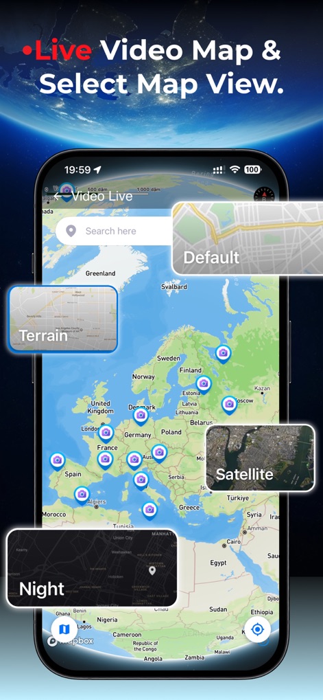
사용자는 이 실시간 영상 지도를 통해 유럽 전역의 라이브 카메라 아이콘을 확인하고, 위성 및 지형을 포함한 다양한 지도 보기 옵션을 선택하여 맞춤형 경험을 즐길 수 있습니다.
실시간 영상 지도
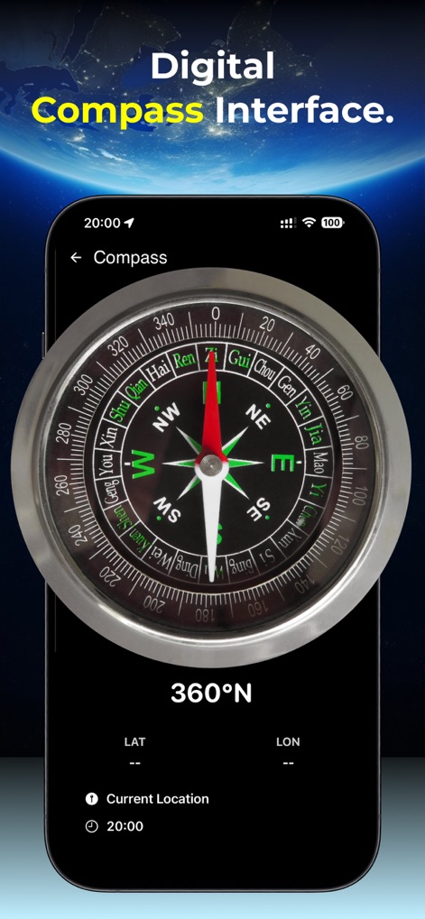
이 도구는 정확한 디지털 나침반 기능을 제공하여 360도 방향을 명확하게 표시하며, 현재 위치의 위도와 경도 정보를 통해 사용자에게 정확한 지리적 데이터를 제공합니다.
정확한 디지털 나침반
설명
Download
비슷한 앱
유사한 기능과 사용자 경험을 가진 앱

Realtime Altimeter
Zhenlai Xia

Travel Camera & Compass
Ha Nguyen

compass-latitude and longitude
美霞 熊

Compass ×
DOUBLE U s.r.o.

GPS Altitude-海拔表
祥琦 孔

Compass: GPS & Altimeter
Shanghai BRC Internet Technology Co., Ltd.

Compass - GPS positioning
嘉 罗

Compass360X-GPS Speedometer
卫豪 吴

指南针-GPS经纬度海拔定位
Chongqing Xinzhi Space Technology Co., Ltd.
이 페이지는 앱이나 개발자의 공식 페이지가 아니며, 정보 제공 및 논평을 목적으로 작성된 독립 편집 간행물입니다. 명시적으로 달리 언급되지 않는 한, 해당 앱이나 개발자는 MWM, Apple, Google Play, 앱 퍼블리셔 또는 앱 개발자와 제휴, 보증, 후원, 승인 또는 공식적으로 연결되어 있지 않으며, 이 페이지의 어떤 내용도 해당 앱이 MWM의 서비스를 사용하여 개발되었음을 의미하지 않습니다. 모든 상표, 로고, 스크린샷 및 기타 콘텐츠는 해당 소유자의 자산입니다.