이 페이지는 앱이나 개발자의 공식 페이지가 아니며, 정보 제공 및 논평을 목적으로 작성된 독립 편집 간행물입니다. 명시적으로 달리 언급되지 않는 한, 해당 앱이나 개발자는 MWM, Apple, Google Play, 앱 퍼블리셔 또는 앱 개발자와 제휴, 보증, 후원, 승인 또는 공식적으로 연결되어 있지 않으며, 이 페이지의 어떤 내용도 해당 앱이 MWM의 서비스를 사용하여 개발되었음을 의미하지 않습니다. 모든 상표, 로고, 스크린샷 및 기타 콘텐츠는 해당 소유자의 자산입니다.

UTM Geo Map Y2Tech
장치를 전문가 수준의 휴대용 GPS로 변환하십시오. 엔지니어 및 지질학자를 위해 제작된 오프라인 공간 분석 도구를 사용하여 고정밀 UTM/MGRS 좌표를 캡처하고, 등고선을 생성하고, 현장 말뚝 작업을 수행하십시오.
다운로드
5K+사용자 평점
총 평가 수
0개발사
카테고리
Navigation지원 언어
6최신 버전
1.0.11크기
21.3 MB출시일
2025년 10월 28일주머니 속 전문가급 GIS 및 측량 파워
비싼 휴대용 GPS 장치를 대체하도록 설계된 고정밀 좌표 추적, 공간 분석 및 현장 매핑을 위한 전문가급 툴킷으로 팀을 장비하십시오.
전문가급 오프라인 정밀도
셀 서비스가 없는 외딴 오프라인 위치에서도 미터 이하의 정밀도로 UTM, MGRS 및 MSL 고도 데이터를 캡처합니다.
고급 공간 분석
버퍼링, 오버레이 및 말뚝 작업과 같은 복잡한 GIS 작업을 현장에서 직접 수행합니다. 전문적인 정확도로 면적과 거리를 계산합니다.
자주 묻는 질문
에 대해 알아야 할 모든 것 UTM Geo Map Y2Tech
UTM Geo Map Y2Tech란 무엇인가요?
UTM Geo Map Y2Tech는 측량, 지형, 수심 측량 및 GIS를 위한 무료의 간단한 애플리케이션입니다. 좌표, 공간 분석 및 측정을 위한 도구를 제공하며 다양한 공학 및 지질학 분야에 적합합니다.
UTM Geo Map Y2Tech는 무료 애플리케이션인가요?
네, UTM Geo Map Y2Tech는 무료 애플리케이션입니다. 측량 및 GIS에 대한 광범위한 기능을 제공합니다. MSL 고도, 등고선, 고도 프로필과 같은 특정 모듈은 구매가 필요한 프리미엄 기능입니다.
인터넷 연결 없이 UTM Geo Map Y2Tech를 사용할 수 있나요?
네, UTM Geo Map Y2Tech에는 오프라인 GPS 모듈이 포함되어 있습니다. 이를 통해 사용자는 인터넷 연결 없이 위도 경도, UTM, MGRS 좌표 및 고도 데이터를 얻을 수 있습니다.
UTM Geo Map Y2Tech는 어떤 종류의 좌표를 얻을 수 있나요?
UTM Geo Map Y2Tech는 EPSG 코드를 사용하여 위도 경도, UTM, MGRS 및 기타 좌표 참조 시스템을 얻습니다. 또한 MSL 고도(프리미엄)를 제공하고 포괄적인 데이터로 포인트를 플로팅할 수 있습니다.
UTM Geo Map Y2Tech는 어떻게 면적 및 거리 측정을 수행하나요?
UTM Geo Map Y2Tech는 다양한 단위로 면적 및 거리를 측정하고, 선/다각형을 등록하며, 자동으로 다각형을 생성합니다. 스냅 니어리스트와 같은 공간 편집 기능을 지원하며 무제한 데이터를 저장할 수 있습니다.
UTM Geo Map Y2Tech는 버퍼링 및 오버레이와 같은 공간 분석을 지원하나요?
네, UTM Geo Map Y2Tech에는 공간 분석을 위한 간단한 GIS 모듈이 포함되어 있습니다. 합집합, 교집합, 차집합, 대칭 차집합과 같은 옵션을 사용하여 버퍼링 및 오버레이를 수행하며, 다각형에 대한 음수 버퍼도 포함합니다.
UTM Geo Map Y2Tech에서 등고선을 어떻게 생성하나요?
UTM Geo Map Y2Tech에는 프리미엄 등고선 모듈이 있습니다. 이 모듈은 원하는 등고선 수, 고도 또는 지정된 등고선 간격을 기반으로 등고선을 생성합니다. 인터넷 연결이 필요합니다.
UTM Geo Map Y2Tech는 좌표 형식을 변환할 수 있나요?
네, UTM Geo Map Y2Tech에는 좌표 변환기 모듈이 있습니다. 위도 경도, UTM 및 MGRS 간에 수동으로 좌표를 변환합니다. 이 모듈은 주소를 좌표로 변환하는 지오코딩도 지원합니다.
UTM Geo Map Y2Tech는 저장된 포인트에 대해 어떤 내보내기 형식을 지원하나요?
UTM Geo Map Y2Tech는 저장된 포인트를 CSV 또는 KML 파일로 내보내기를 지원합니다. 이 기능은 지도 좌표를 통해 플로팅된 포인트와 오프라인 GPS 모듈을 통해 저장된 데이터에 대해 사용할 수 있습니다.
UTM Geo Map Y2Tech는 현장에서 위치를 찾는 데 어떻게 도움이 되나요?
UTM Geo Map Y2Tech는 '포인트 찾기' 모듈을 제공합니다. 이 모듈은 사용자가 현장에서 특정 좌표를 찾도록 도와주며, 측량 작업을 위해 장치의 내장 GPS 및 나침반을 사용합니다.
다음 스크린샷과 설명은 앱의 공식 스토어 목록에서 직접 가져온 것이며 앱 개발자의 자산입니다.
앱 스토어
스크린샷
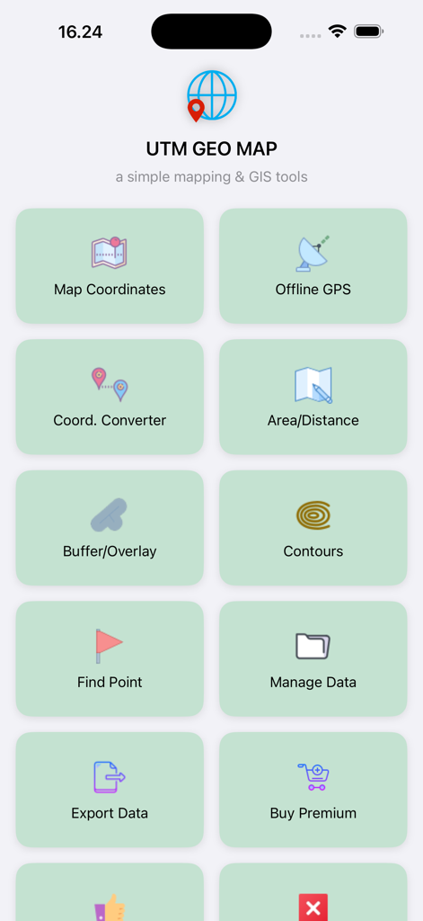
전문 GIS 및 측량 도구 모듈을 보여주는 UTM Geo Map 앱의 메인 메뉴
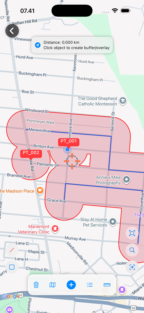
거리 지도에 빨간색 버퍼 영역 및 공간 분석을 보여주는 모바일 GIS 인터페이스
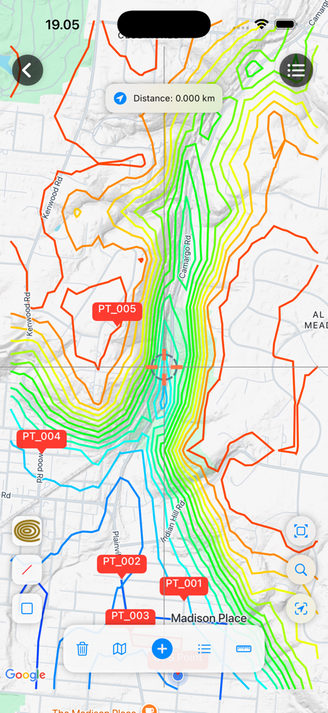
UTM Geo Map 인터페이스에 지형 등고선 및 측량 포인트 표시
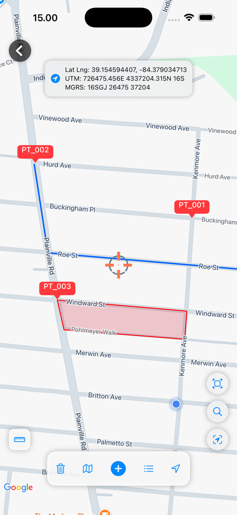
UTM Geo Map 인터페이스에 측량 마커 및 UTM 및 MGRS 좌표가 있는 영역 다각형 표시
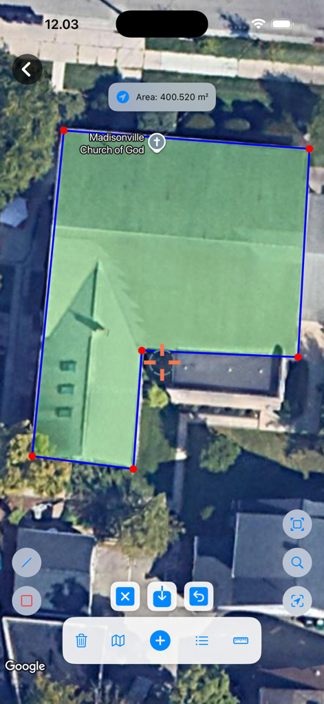
건물의 다각형 면적 측정을 보여주는 UTM Geo Map 앱의 위성 뷰
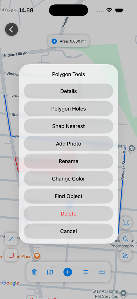
매핑 옵션이 있는 UTM Geo Map 앱 인터페이스의 다각형 도구 메뉴
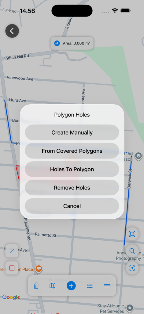
UTM Geo Map 측량 애플리케이션의 다각형 구멍 메뉴 옵션
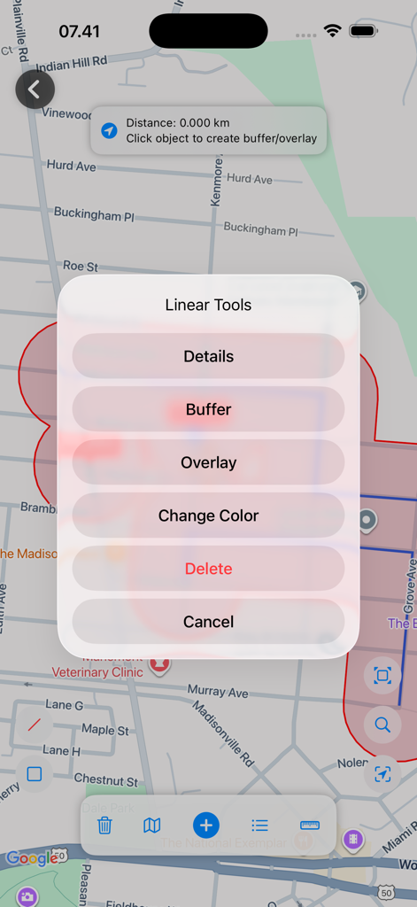
거리 지도에 버퍼 및 오버레이와 같은 선형 GIS 도구를 보여주는 UTM Geo Map 인터페이스
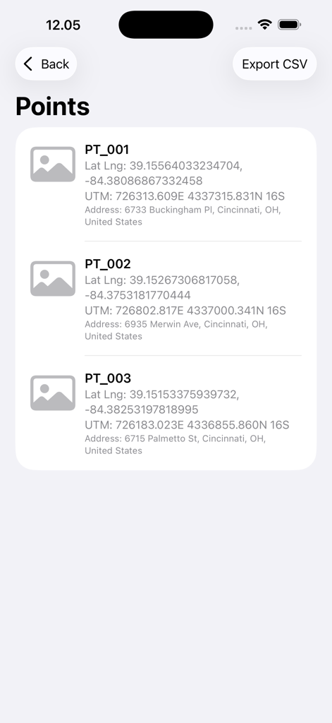
UTM 및 위도 경도 좌표를 보여주는 등록된 지리적 포인트 목록

전문 말뚝 작업 작업을 위한 대상 좌표 및 거리를 보여주는 탐색 화면
설명
Download
비슷한 앱
같은 카테고리의 상위 앱

Google Maps
Google LLC

Waze Navigation & Live Traffic
waze

AMap Global
AutoNavi Information Technology Co. Ltd.

百度地图-路线规划,出行必备
Beijing Baidu Netcom Science & Technology Co.,Ltd

Moovit: Bus & Transit Tracker
Moovit App Global LTD

Transit • Subway & Bus Times
9280-0366 Quebec inc.

ParkMobile: Park. Pay. Go.
Parkmobile USA, Inc

腾讯地图-路线规划,导航地铁打车出行
Shenzhen Tencent Computer Systems Company Limited

Île-de-France Mobilités
Ile de France Mobilites
이 페이지는 앱이나 개발자의 공식 페이지가 아니며, 정보 제공 및 논평을 목적으로 작성된 독립 편집 간행물입니다. 명시적으로 달리 언급되지 않는 한, 해당 앱이나 개발자는 MWM, Apple, Google Play, 앱 퍼블리셔 또는 앱 개발자와 제휴, 보증, 후원, 승인 또는 공식적으로 연결되어 있지 않으며, 이 페이지의 어떤 내용도 해당 앱이 MWM의 서비스를 사용하여 개발되었음을 의미하지 않습니다. 모든 상표, 로고, 스크린샷 및 기타 콘텐츠는 해당 소유자의 자산입니다.