이 페이지는 앱이나 개발자의 공식 페이지가 아니며, 정보 제공 및 논평을 목적으로 작성된 독립 편집 간행물입니다. 명시적으로 달리 언급되지 않는 한, 해당 앱이나 개발자는 MWM, Apple, Google Play, 앱 퍼블리셔 또는 앱 개발자와 제휴, 보증, 후원, 승인 또는 공식적으로 연결되어 있지 않으며, 이 페이지의 어떤 내용도 해당 앱이 MWM의 서비스를 사용하여 개발되었음을 의미하지 않습니다. 모든 상표, 로고, 스크린샷 및 기타 콘텐츠는 해당 소유자의 자산입니다.

Ventusky: Weather & Live Radar
20개 이상의 글로벌 모델과 고화질 레이더의 융합으로 계획을 강화하세요. 광고 없이 개인 정보 보호에 중점을 둔 대화형 3D 지구본에서 초지역적 정밀도를 경험하세요.
다운로드
1M+사용자 평점
총 평가 수
76K+개발사
카테고리
Weather지원 언어
39최신 버전
50.3크기
68.4 MB출시일
2017년 9월 12일모든 모험을 위한 전문가 수준의 정밀도
총체적인 환경 인식을 요구하는 사람들을 위해 설계된 20개 이상의 글로벌 날씨 모델과 고해상도 시각화의 융합을 경험하세요.
다중 모델 예보 융합
ICON 및 ECMWF와 같은 세계 최고의 모델을 초지역적 해상도로 비교하여 데이터 변경으로 인해 계획이 손상되지 않도록 하세요.
80개 이상의 고밀도 지도
3D 바람 애니메이션, CAPE 지수, 고도별 레이어를 포함한 깊은 데이터 레이어를 탐색하여 조종사, 선원 및 드론 운영자에게 적합합니다.
자주 묻는 질문
에 대해 알아야 할 모든 것 Ventusky: Weather & Live Radar
Ventusky: 날씨 지도 및 레이더란 무엇인가요?
Ventusky는 20개 이상의 글로벌 모델, 실시간 레이더, 위성, 40,000개 이상의 웹캠을 통합한 올인원 날씨 앱입니다. 조깅부터 대서양 횡단 비행까지 모든 것을 계획할 수 있는 업계 최고 수준의 정확도를 제공합니다.
Ventusky는 초지역 날씨 예보를 제공하나요?
네, Ventusky는 시간별 해상도의 초지역 14일 날씨 예보를 제공합니다. 이 기능은 야외 활동 계획 및 갑작스러운 날씨 변화 방지에 중요한 정확한 업데이트를 제공합니다.
Ventusky에는 몇 개의 날씨 지도가 있나요?
Ventusky에는 80개 이상의 날씨 지도가 있습니다. 이 지도들은 온도, 강수량, 돌풍, 대기 질을 포함한 다양한 현상에 대한 포괄적인 보기를 제공합니다.
사용자는 Ventusky 앱을 사용하여 허리케인을 추적할 수 있나요?
네, Ventusky는 허리케인 및 폭풍 추적 기능을 제공합니다. 사용자는 여러 모델의 경로를 비교하여 열대성 폭풍 동안 대비와 안전을 보장할 수 있습니다.
Ventusky에는 실시간 레이더 및 번개 감지 기능이 포함되어 있나요?
네, Ventusky는 실시간 레이더 및 번개 감지 기능을 통합합니다. 이 기능은 분 단위 예측을 제공하여 폭풍 활동 및 번개 타격의 실시간 모니터링을 가능하게 합니다.
Ventusky는 예측에 어떤 날씨 모델을 사용하나요?
Ventusky는 ECMWF, GFS, 독일 ICON 모델을 포함한 20개 이상의 고급 수치 일기 예보 시스템의 데이터를 통합합니다. 모든 위치에 대해 가장 정확한 모델을 자동으로 선택합니다.
Ventusky는 다른 고도의 바람 패턴을 애니메이션으로 표시할 수 있나요?
네, Ventusky는 두 가지 다른 고도의 이중 바람 애니메이션을 제공합니다. 전문가를 위해 16가지 고도(0m–13km)에서 패턴을 애니메이션으로 표시하는 항공 바람 층을 제공하여 비행 경로 최적화를 지원합니다.
Ventusky는 대기 질에 대한 정보를 제공하나요?
네, Ventusky는 광범위한 대기 질 정보를 제공합니다. PM2.5, NO2, 오존 수준 등에 대한 SILAM 모델 데이터를 활용하여 사용자가 활동을 계획하고 건강을 모니터링하는 데 도움을 줍니다.
Ventusky는 홈 및 잠금 화면 위젯을 지원하나요?
네, Ventusky는 잠금 및 홈 화면 위젯을 지원합니다. 이러한 위젯은 예측, 웹캠 또는 레이더 정보를 표시하여 날씨 데이터에 즉시 액세스할 수 있도록 합니다.
Ventusky 앱은 광고 및 추적 기능이 없나요?
네, Ventusky 앱은 광고나 추적 스크립트가 전혀 없습니다. 이를 통해 개인적이고 중단 없는 사용자 경험을 보장합니다.
다음 스크린샷과 설명은 앱의 공식 스토어 목록에서 직접 가져온 것이며 앱 개발자의 자산입니다.
앱 스토어
스크린샷
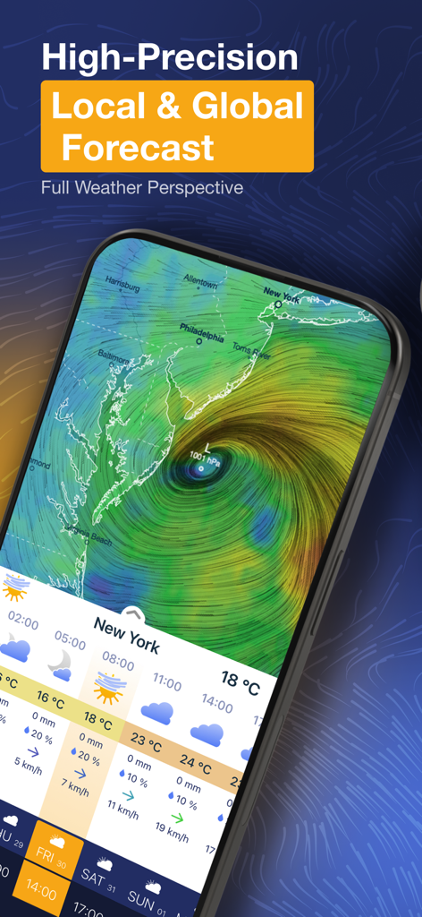
Ventusky 앱이 미국 동부 해안의 고정밀 지역 일기 예보와 대화형 바람 지도를 표시합니다.
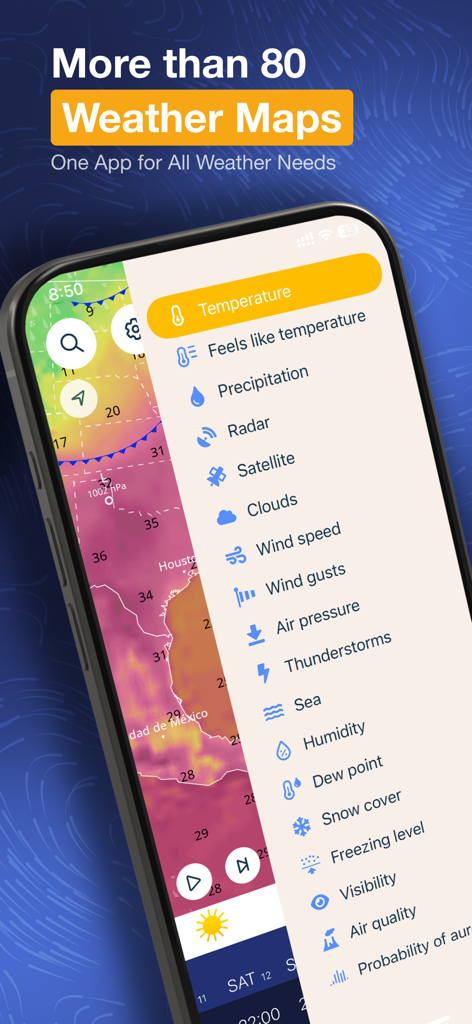
열 지도 위에 온도, 바람, 강수량과 같은 다양한 날씨 지도 레이어가 나열된 측면 메뉴가 있는 Ventusky 앱을 보여주는 스마트폰 화면
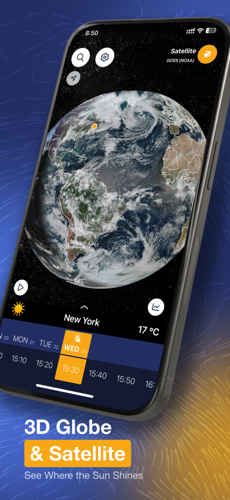
3D 대화형 지구본과 위성 날씨 이미지가 있는 Ventusky 앱을 보여주는 스마트폰 화면
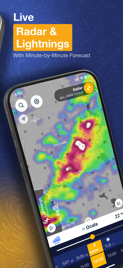
고해상도 대화형 지도에 실시간 날씨 레이더 및 낙뢰 데이터가 표시된 Ventusky 앱 인터페이스
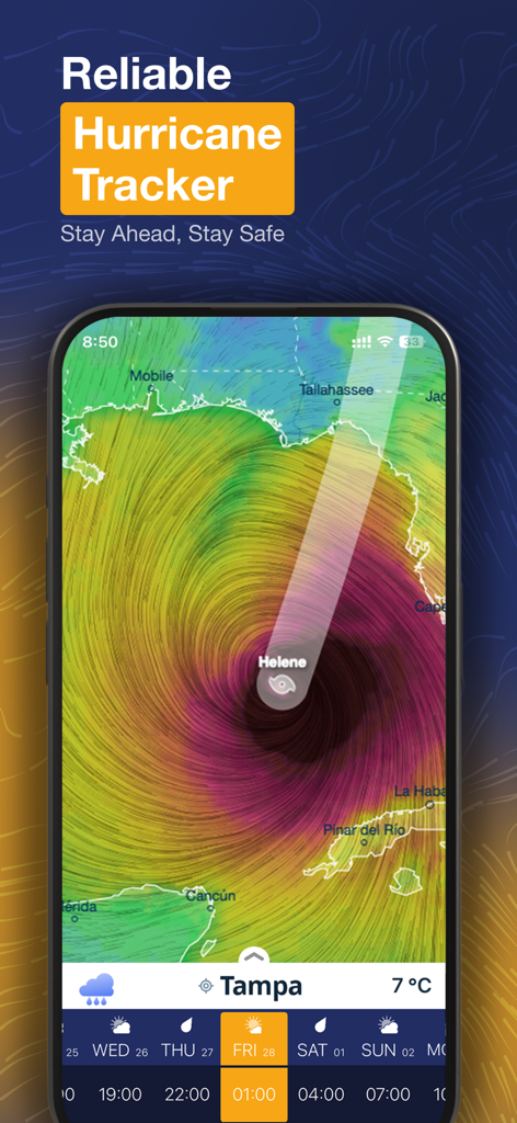
멕시코만과 플로리다 해안의 헬렌 허리케인을 보여주는 Ventusky 앱 허리케인 추적기 인터페이스
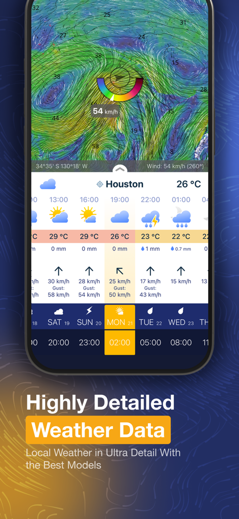
휴스턴에 대한 Ventusky 앱의 상세 일기 예보 및 바람 지도 인터페이스
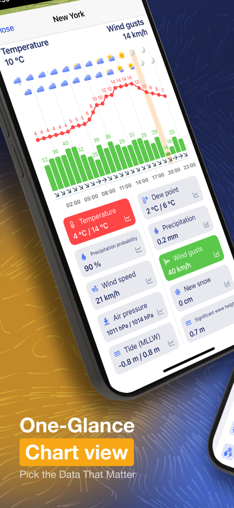
뉴욕에 대한 상세한 날씨 차트 및 데이터 타일을 보여주는 Ventusky 모바일 앱.
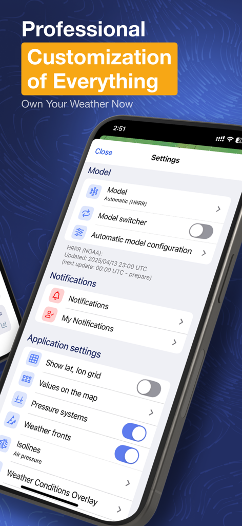
Ventusky 앱 설정 화면에는 날씨 모델 및 지도 레이어에 대한 전문가 사용자 지정 옵션이 표시됩니다.
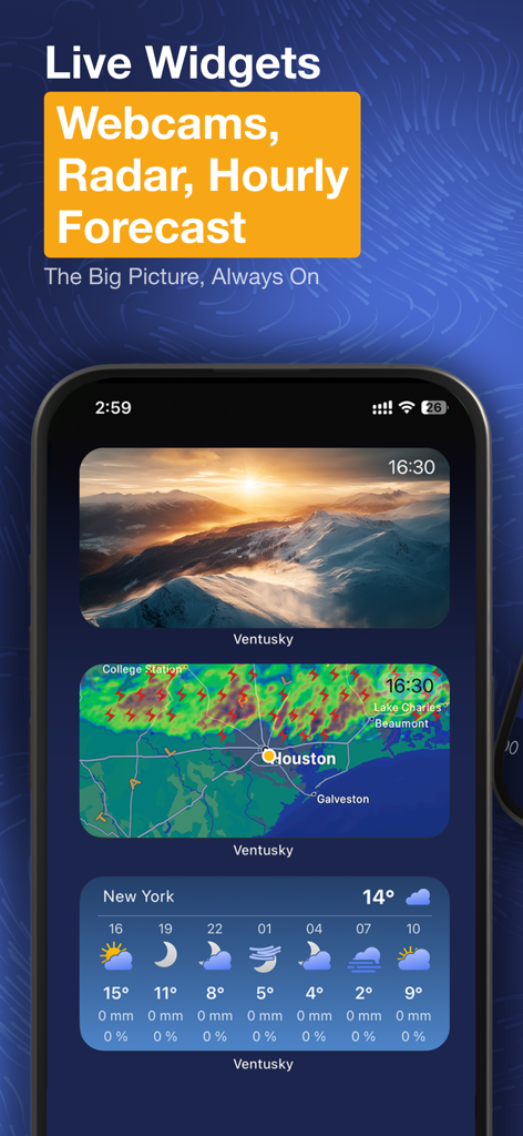
iPhone의 산악 웹캠, 실시간 레이더 지도 및 시간별 예보에 대한 홈 화면 위젯을 보여주는 Ventusky 날씨 앱.
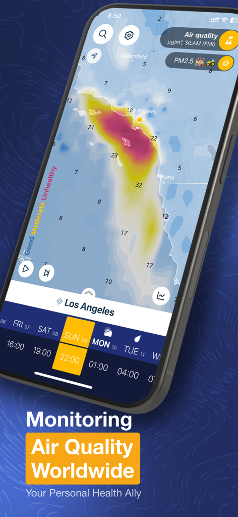
LA 2.5pm 데이터를 포함한 로스앤젤레스의 상세한 대기질 히트맵을 보여주는 Ventusky 모바일 앱 스크린샷
설명
Download
비슷한 앱
유사한 기능과 사용자 경험을 가진 앱

墨迹天气-MojiWeather
Beijing MojiFengyun Technology Co.,Ltd.

Windy.com
Windyty, SE

天气通
Weibo Internet Technology (China) Co.Ltd.

Zoom Earth - Weather Forecast
Neave Interactive Limited

实时天气-40日精准天气实时预报
犇 牛

MyRadar Accurate Weather Radar
Aviation Data Systems, Inc

FOX Weather: Daily Forecasts
Fox News Network, LLC

2345天气王-天气和空气质量查询小组件
Shanghai 2345 Network Technology Co., Ltd.

Weather & Widget - Weawow
weawow Inc.
이 페이지는 앱이나 개발자의 공식 페이지가 아니며, 정보 제공 및 논평을 목적으로 작성된 독립 편집 간행물입니다. 명시적으로 달리 언급되지 않는 한, 해당 앱이나 개발자는 MWM, Apple, Google Play, 앱 퍼블리셔 또는 앱 개발자와 제휴, 보증, 후원, 승인 또는 공식적으로 연결되어 있지 않으며, 이 페이지의 어떤 내용도 해당 앱이 MWM의 서비스를 사용하여 개발되었음을 의미하지 않습니다. 모든 상표, 로고, 스크린샷 및 기타 콘텐츠는 해당 소유자의 자산입니다.