이 페이지는 앱이나 개발자의 공식 페이지가 아니며, 정보 제공 및 논평을 목적으로 작성된 독립 편집 간행물입니다. 명시적으로 달리 언급되지 않는 한, 해당 앱이나 개발자는 MWM, Apple, Google Play, 앱 퍼블리셔 또는 앱 개발자와 제휴, 보증, 후원, 승인 또는 공식적으로 연결되어 있지 않으며, 이 페이지의 어떤 내용도 해당 앱이 MWM의 서비스를 사용하여 개발되었음을 의미하지 않습니다. 모든 상표, 로고, 스크린샷 및 기타 콘텐츠는 해당 소유자의 자산입니다.

Zoom Earth - Weather Forecast
놀라운 대화형 지도와 실시간 위성 이미지를 통해 전문가 수준의 기상 정보를 경험해 보세요. 주요 허리케인 추적부터 산불 모니터링까지, 10분마다 업데이트되는 데이터로 정보를 얻고 대비하세요.
다운로드
2M+사용자 평점
총 평가 수
122K+개발사
카테고리
Weather지원 언어
14최신 버전
5.0.1크기
52.3 MB출시일
2023년 6월 27일변화하는 세상을 위한 시각적 통찰력
최첨단 대화형 날씨 지도를 경험하세요. 고화질 위성 이미지와 전문가 수준의 추적 도구를 결합하여 날씨 변화에 한 발 앞서 대비할 수 있습니다.
거의 실시간 위성 피드
NOAA 및 NASA 위성에서 10분마다 업데이트되는 HD 이미지를 통해 전 세계 날씨 패턴을 관찰하고 원시 데이터를 직접 화면에 표시합니다.
정밀 위험 추적
기상 전문가 및 긴급 구조대가 사용하는 것과 동일한 데이터로 허리케인, 산불 및 악천후를 모니터링하여 집과 가족을 보호하세요.
자주 묻는 질문
에 대해 알아야 할 모든 것 Zoom Earth - Weather Forecast
Zoom Earth - 날씨 예보는 무엇인가요?
Zoom Earth는 전 세계의 비, 바람, 온도, 기압 등에 대한 예보를 제공하는 대화형 날씨 지도 및 실시간 허리케인 추적기입니다.
Zoom Earth는 실시간 날씨 정보를 제공하나요?
네, Zoom Earth는 10분마다 업데이트되는 거의 실시간 위성 이미지와 도플러 레이더를 통한 실시간 비/눈 감지 및 즉시 예보를 제공합니다.
Zoom Earth는 허리케인을 실시간으로 추적할 수 있나요?
네, Zoom Earth는 허리케인의 발생부터 5등급까지 실시간으로 추적합니다. NHC, JTWC, NRL, IBTrACS의 최신 데이터를 사용하여 업데이트됩니다.
Zoom Earth는 산불을 보여주나요?
네, Zoom Earth는 NASA FIRMS의 데이터를 사용하여 매일 업데이트되는 활성 화재 및 열점 오버레이로 산불을 모니터링합니다. 산불 연기 이동도 보여줍니다.
Zoom Earth에서 어떤 날씨 예보 지도를 볼 수 있나요?
Zoom Earth는 강수량, 풍속, 돌풍, 온도, "체감" 온도, 상대 습도, 이슬점, 대기압에 대한 예보 지도를 제공합니다.
Zoom Earth PRO 구독은 어떻게 작동하나요?
Zoom Earth PRO는 자동 갱신 구독을 통해 추가 기능을 제공합니다. 결제는 App Store 계정으로 청구되며, 24시간 전에 비활성화하지 않으면 자동으로 갱신됩니다.
Zoom Earth에서 설정을 사용자 지정할 수 있나요?
네, Zoom Earth에서는 종합적인 설정을 통해 온도 단위, 바람 단위, 시간대 및 애니메이션 스타일을 사용자 지정할 수 있습니다.
Zoom Earth의 위성 이미지는 얼마나 자주 업데이트되나요?
실시간 위성 이미지는 위성 소스에 따라 10분 또는 15분마다 업데이트됩니다. HD 위성 이미지는 하루에 두 번 업데이트됩니다.
Zoom Earth에 비 레이더 지도가 포함되어 있나요?
네, Zoom Earth는 지상 기반 도플러 레이더로 감지된 실시간 비와 눈을 표시하는 날씨 레이더 지도를 제공합니다. 즉각적인 단기 날씨 예보를 제공합니다.
Zoom Earth에서 풍속 정보를 볼 수 있나요?
네, Zoom Earth는 표면 바람의 평균 속도와 방향을 보여주는 상세한 풍속 예보 지도와 돌풍 예보 정보를 제공합니다.
다음 스크린샷과 설명은 앱의 공식 스토어 목록에서 직접 가져온 것이며 앱 개발자의 자산입니다.
앱 스토어
스크린샷
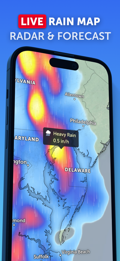
Zoom Earth 앱이 동부 해안 지역의 폭우 경보 및 레이더 예보와 함께 실시간 강우 지도에 표시됨.
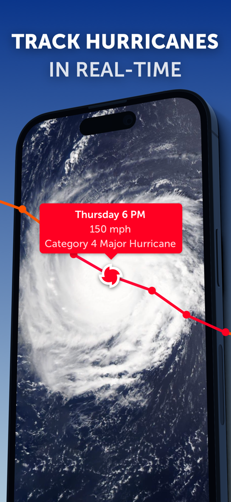
Zoom Earth 앱 인터페이스에 4등급 허리케인에 대한 실시간 위성 추적 및 데이터가 표시됨.
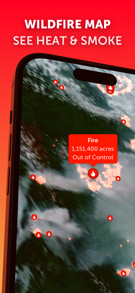
Zoom Earth 앱이 통제 불능 상태의 산불 데이터와 열 지점을 보여주는 실시간 산불 지도에 표시됨.
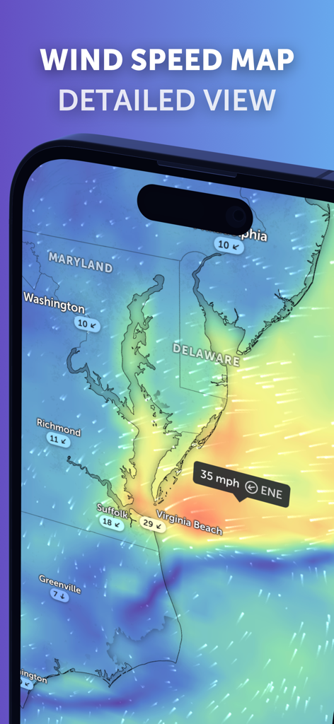
Zoom Earth 모바일 앱 인터페이스에서 메릴랜드와 버지니아 지역의 현재 상황을 보여주는 상세한 풍속 예보 지도.
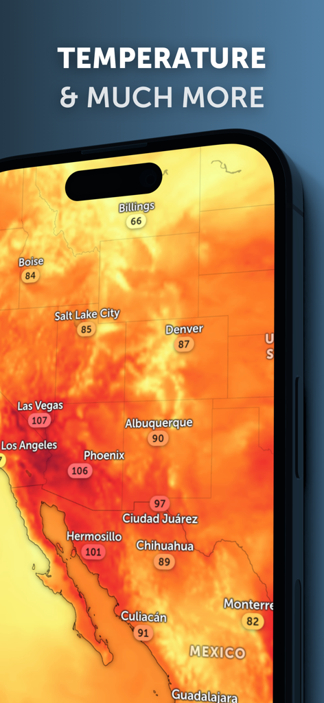
Zoom Earth 앱이 스마트폰에서 북미 지역의 온도 열 지도를 표시함.
설명
Download
비슷한 앱
유사한 기능과 사용자 경험을 가진 앱

墨迹天气-MojiWeather
Beijing MojiFengyun Technology Co.,Ltd.

Windy.com
Windyty, SE

天气通
Weibo Internet Technology (China) Co.Ltd.

实时天气-40日精准天气实时预报
犇 牛

MyRadar Accurate Weather Radar
Aviation Data Systems, Inc

Ventusky: Weather & Live Radar
Ventusky s.r.o.

FOX Weather: Daily Forecasts
Fox News Network, LLC

2345天气王-天气和空气质量查询小组件
Shanghai 2345 Network Technology Co., Ltd.

Weather & Widget - Weawow
weawow Inc.
이 페이지는 앱이나 개발자의 공식 페이지가 아니며, 정보 제공 및 논평을 목적으로 작성된 독립 편집 간행물입니다. 명시적으로 달리 언급되지 않는 한, 해당 앱이나 개발자는 MWM, Apple, Google Play, 앱 퍼블리셔 또는 앱 개발자와 제휴, 보증, 후원, 승인 또는 공식적으로 연결되어 있지 않으며, 이 페이지의 어떤 내용도 해당 앱이 MWM의 서비스를 사용하여 개발되었음을 의미하지 않습니다. 모든 상표, 로고, 스크린샷 및 기타 콘텐츠는 해당 소유자의 자산입니다.