이 페이지는 앱이나 개발자의 공식 페이지가 아니며, 정보 제공 및 논평을 목적으로 작성된 독립 편집 간행물입니다. 명시적으로 달리 언급되지 않는 한, 해당 앱이나 개발자는 MWM, Apple, Google Play, 앱 퍼블리셔 또는 앱 개발자와 제휴, 보증, 후원, 승인 또는 공식적으로 연결되어 있지 않으며, 이 페이지의 어떤 내용도 해당 앱이 MWM의 서비스를 사용하여 개발되었음을 의미하지 않습니다. 모든 상표, 로고, 스크린샷 및 기타 콘텐츠는 해당 소유자의 자산입니다.

VesselFinder
이 앱은 당신에게 지구상 모든 선박의 움직임을 알려줍니다. 더 이상 추측에 의존하지 마십시오.
다운로드
1M+사용자 평점
총 평가 수
585개발사
카테고리
Navigation지원 언어
1최신 버전
6.2.1크기
44.3 MB출시일
2014년 9월 23일실시간 해상 교통 추적 및 정보 제공 솔루션 평가
VesselFinder 앱 주요 기능 분석
실시간 선박 추적
이 앱은 전 세계 30만 척 이상의 선박을 AIS 데이터를 활용하여 실시간으로 추적할 수 있도록 지원합니다. 사용자는 선박의 현재 위치와 이동 경로를 정확하게 파악할 수 있습니다.
항만별 입출항 현황
이 앱은 항만별로 예상 선박, 도착, 출발 및 현재 정박 중인 선박의 상세 목록을 제공합니다. 사용자는 특정 항만의 실시간 활동을 종합적으로 파악할 수 있습니다.
예상 경로 및 다음 항구 도착 예정 시간 (ETA)
이 기능은 선박의 예상 경로와 다음 항구 도착 예정 시간을 제공합니다. 사용자는 물류 계획 및 운영 효율성을 높일 수 있습니다.
날씨 오버레이 정보
이 도구는 바람, 파도, 온도 등 날씨 오버레이 정보를 제공합니다. 사용자는 해상 날씨 조건을 파악하여 항해 안전 및 계획에 참고할 수 있습니다.
상세 선박 정보
이 앱은 기술 사양 및 화물 적재 용량을 포함한 포괄적인 선박 정보를 제공합니다. 사용자는 선박의 특성과 성능을 상세히 파악할 수 있습니다.
선박별 입항 기록
이 도구는 선박별 입항 기록, 도착 시간 및 체류 기간을 표시합니다. 사용자는 특정 선박의 항만 활동 이력을 쉽게 확인할 수 있습니다.
선박 이동 기록 및 경로 시각화
이 도구는 선박의 과거 이동 기록을 경로 시각화와 함께 제공합니다. 사용자는 특정 선박의 과거 움직임을 분석하고 시각적으로 확인할 수 있습니다.
거리 측정 도구
이 기능은 경로 및 범위 추정을 위한 거리 측정 도구를 제공합니다. 사용자는 지도상의 두 지점 간 거리를 정확하게 측정할 수 있습니다.
내 선박 관리 (My Fleet)
이 기능은 사용자가 즐겨찾는 선박을 저장하고 모니터링할 수 있게 해줍니다. 사용자의 VesselFinder 계정과 동기화되어 편리한 관리를 제공합니다.
다양한 지도 스타일
이 앱은 단순, 상세, 어둡게, 위성, 해도 등 다양한 지도 스타일을 제공합니다. 사용자는 개인적인 선호도와 필요에 따라 최적의 시각화 환경을 선택할 수 있습니다.
자주 묻는 질문
에 대해 알아야 할 모든 것 VesselFinder
What is VesselFinder Lite?
VesselFinder Lite is a marine traffic app providing real-time information on ship positions and movements worldwide. It uses a network of satellites, roaming, and terrestrial AIS receivers.
Does VesselFinder Lite provide real-time vessel tracking?
Yes, VesselFinder Lite provides real-time tracking for over 300,000 vessels daily using global AIS data. The app offers up-to-date insight into global maritime activity.
How does VesselFinder Lite ensure global AIS data coverage?
VesselFinder Lite utilizes a powerful network of satellites, roaming, and terrestrial AIS receivers to deliver global AIS data. Vessel visibility within the app depends on AIS signal availability.
Can I view a vessel's movement history in VesselFinder Lite?
Yes, VesselFinder Lite includes vessel movement history with track visualization. If a vessel is outside terrestrial AIS coverage, its last reported position is displayed and updated when new data is received.
Does VesselFinder Lite show predicted routes and ETAs?
Yes, VesselFinder Lite provides predicted routes and Estimated Times of Arrival (ETAs) to the next port. This feature helps users monitor and plan for vessel movements efficiently.
What kind of vessel particulars does VesselFinder Lite offer?
VesselFinder Lite provides comprehensive vessel particulars, including technical specifications, cargo capacity, and contact details for the owning company, manager, and ISM manager.
How does VesselFinder Lite display port call information?
VesselFinder Lite displays Port Calls per vessel with arrival times and duration of stay. It also provides detailed lists for ports, including expected vessels, arrivals, departures, and ships currently in port.
Can I save my favorite vessels in VesselFinder Lite?
Yes, VesselFinder Lite allows users to save and monitor favorite vessels using the "My Fleet" feature. This data synchronizes with your VesselFinder account for convenience.
What map styles are available in VesselFinder Lite?
VesselFinder Lite offers multiple map styles: Simple, Detailed, Dark, Satellite, and Nautical. Users can also save preferred map views with the "My Views" feature for quick access.
Is extended real-time coverage available in VesselFinder Lite?
Yes, extended real-time coverage via satellite and roaming AIS sources is available through a subscription within VesselFinder Lite. This provides data beyond terrestrial AIS areas.
Does VesselFinder Lite include weather information?
Yes, VesselFinder Lite integrates weather overlays including wind, waves, and temperature. This enhances the maritime tracking experience with relevant environmental data.
Can I measure distances on the map in VesselFinder Lite?
Yes, VesselFinder Lite provides a distance measurement tool. This feature enables users to accurately estimate routes and ranges directly on the app's map interface.
Is the information provided by VesselFinder Lite guaranteed to be accurate?
No, while VesselFinder Lite strives for accuracy, the completeness of its information cannot be guaranteed. This is due to reliance on AIS signal availability and data reception.
다음 스크린샷과 설명은 앱의 공식 스토어 목록에서 직접 가져온 것이며 앱 개발자의 자산입니다.
앱 스토어
스크린샷

사용자는 지중해와 대서양을 가로지르는 여러 척의 선박 아이콘과 'NORTHERN ROCK'이라는 특정 선박의 목적지 및 속도 정보를 실시간으로 확인할 수 있습니다.
전 세계 선박 추적
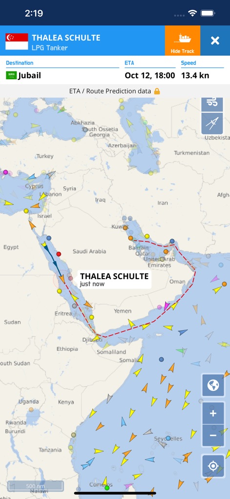
이 앱은 'THALEA SCHULTE' 선박의 아라비아해를 가로지르는 예상 경로를 점선으로 명확하게 보여주며, 상단 정보 바에서 목적지 'Jubail'과 도착 예정 시간 'Oct 12, 18:00'을 제공합니다.
예측 경로 시각화

이 도구를 통해 사용자는 선전 항구의 고밀도 선박 트래픽을 관찰하고, 정박 중인 선박을 나타내는 닻 아이콘을 포함한 다양한 선박 아이콘을 통해 세부적인 항구 활동을 파악할 수 있습니다.
항구 활동 모니터링
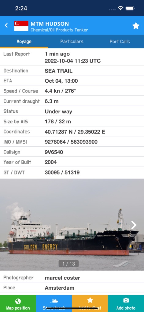
사용자는 'Voyage' 탭에서 선박의 목적지 및 도착 예정 시간과 같은 핵심 운항 정보를 확인할 수 있으며, 화면 하단에는 'GOLDEN ENERGY' 선박의 실제 사진이 제공되어 시각적인 이해를 돕습니다.
상세 운항 정보

이 앱은 선박의 총 톤수와 전체 길이와 같은 자세한 기술 사양을 포함하여, 등록된 소유자 정보까지 명확하게 제공하여 심층적인 분석을 가능하게 합니다.
선박 제원 상세 보기
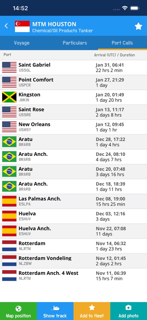
사용자는 선박의 과거 기항 기록을 도착 시간과 체류 기간을 포함하여 면밀히 검토할 수 있으며, 각 기항지 목록 옆에 해당 국가의 국기가 시각적으로 표시됩니다.
기항 기록 탐색

이 도구는 'SINGAPORE' 검색어에 해당하는 여러 선박 목록을 빠르게 제시하며, 각 선박의 종류와 도착 예정지를 함께 표시하여 사용자가 필요한 정보를 손쉽게 찾을 수 있도록 돕습니다.
빠르고 정확한 검색

사용자는 싱가포르 항구의 예상 입항 선박 목록을 ETA(도착 예정 시간) 기준으로 확인할 수 있으며, 다양한 국적의 선박을 나타내는 국기 아이콘이 함께 표시됩니다.
항구 입출항 현황

이 앱은 지도상에 시각화된 항해 경로와 여러 경유지를 통해 상세한 여정을 제공하며, 각 구간의 거리와 방위각 정보를 포함하여 효율적인 경로 계획을 지원합니다.
경로 계획 및 측정

사용자는 'My Fleet' 탭에서 'Cruise ships'나 'Fishing ships'와 같이 개인적으로 저장한 선박 그룹 목록을 볼 수 있으며, 각 그룹에 포함된 선박의 총 수량을 한눈에 확인할 수 있습니다.
나만의 선단 관리
설명
Download
비슷한 앱
유사한 기능과 사용자 경험을 가진 앱

Ship Info
Oleksiy Koldunov

Ship Tracker
Rocketech sp. z o.o.

Boat Watch - Ship Tracking
Pocket Mariner Ltd.

MarineRadar・Vessel Finder
Lascade LLC

Marine Traffic :Ship Tracker
Kathy Spencer

MyShipTracking
Nativity

Boat Beacon
Pocket Mariner Ltd.

Boat Watch Pro
Pocket Mariner Ltd.

Ship Finder
pinkfroot limited
이 페이지는 앱이나 개발자의 공식 페이지가 아니며, 정보 제공 및 논평을 목적으로 작성된 독립 편집 간행물입니다. 명시적으로 달리 언급되지 않는 한, 해당 앱이나 개발자는 MWM, Apple, Google Play, 앱 퍼블리셔 또는 앱 개발자와 제휴, 보증, 후원, 승인 또는 공식적으로 연결되어 있지 않으며, 이 페이지의 어떤 내용도 해당 앱이 MWM의 서비스를 사용하여 개발되었음을 의미하지 않습니다. 모든 상표, 로고, 스크린샷 및 기타 콘텐츠는 해당 소유자의 자산입니다.