This page is not an official page of the app or its developer, but an independent editorial publication created for informational and commentary purposes. Unless expressly stated otherwise, neither the app nor its developer is affiliated with, endorsed by, sponsored by, authorized by, or otherwise officially connected with MWM, Apple, Google Play, the app publisher, or the app's developer, and nothing on this page implies that the app was developed using MWM's services. Any trademarks, logos, screenshots, and other content remain the property of their respective owners.

Dronetag
Ensure full regulatory compliance, manage your professional fleet, and gain real-time airspace awareness with the industry-leading platform for modern drone pilots.
Downloads
11K+User Rating
Total Ratings
0Publisher
Category
NavigationLocales
1Latest Version
2.198.1Size
98.4 MBFirst Released
Aug 28, 2021Everything You Need for Mission-Ready Flights
The ultimate toolkit for professional drone operators to stay compliant, safe, and efficient in any airspace.
Seamless Remote ID Compliance
Retrofit any drone to meet the latest FAA and EU regulations with plug-and-play local and network identification.
Advanced Airspace Awareness
Fly with confidence using interactive maps of restricted zones and real-time monitoring of other aircraft in your vicinity.
Frequently Asked Questions
Everything you need to know about Dronetag
What is the Dronetag app used for?
The Dronetag app is an all-in-one solution for safe drone flights. It helps users comply with European regulations, manage their drone fleet, and stay informed about current flight operations.
Does Dronetag require additional hardware?
Yes, Dronetag requires the Dronetag Mini hardware device. This add-on mounts to any drone, weighs 30 grams, and operates for up to 8 hours on a single charge.
How does Dronetag ensure regulatory compliance?
Dronetag ensures compliance with European regulations by providing local and network remote identification for drones. It also allows users to view restricted airspace zones across the EU.
Can I plan drone flights using the Dronetag app?
Yes, the Dronetag app allows you to plan your drone flights. You can specify the time and altitude for your flight operations within the application.
Does Dronetag provide real-time flight tracking and safety alerts?
Yes, Dronetag provides real-time flight tracking on a map with notifications. It also issues proximity alerts if your drone gets close to another aircraft, enhancing flight safety.
How many drones can I manage with the Dronetag app?
Yes, the Dronetag app allows you to add and manage an unlimited number of unmanned aircraft. This provides comprehensive management for your entire drone fleet.
Does Dronetag keep a record of past drone flights?
Yes, Dronetag maintains a comprehensive flight journal for all your drones. You can also export this flight data from the app for your records.
How can I check the status of my Dronetag Mini device?
The Dronetag app displays the status of your Dronetag Mini device. You can view its online status, battery charge level, and signal strengths for LTE, Bluetooth, and GNSS.
Can Dronetag users see other drones in the airspace?
Yes, Dronetag enables users to see other airspace participants who also have Dronetag devices installed. This feature improves overall situational awareness during flights.
The following screenshots and description are sourced directly from the app's official store listing and are the property of the app developer.
App Store
Screenshots
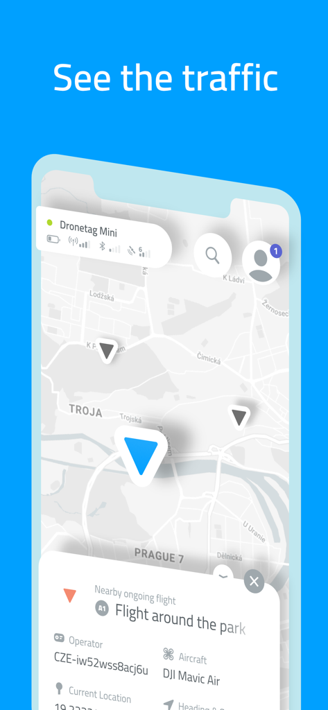
Map view in Dronetag app showing nearby drone traffic and aircraft details
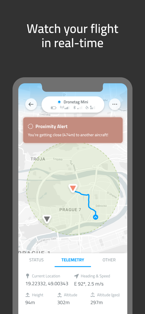
Dronetag app interface showing real time drone flight map with telemetry data and proximity alert
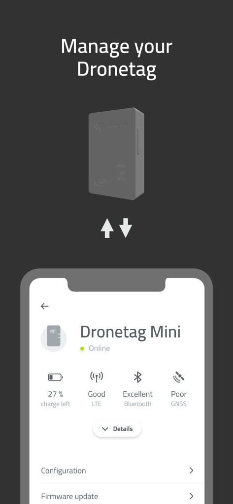
Dronetag app interface displaying the connection status, battery level, and signal strength for a Dronetag Mini device.
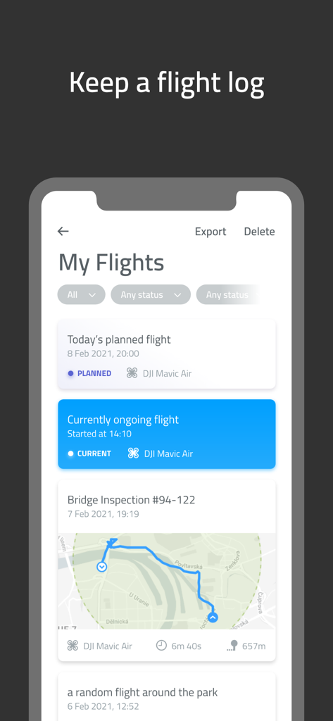
Dronetag mobile app interface displaying a list of drone flight logs with map views and status updates
Description
Download
More Like This
Top-ranked apps in the same category

Google Maps
Google LLC

Waze Navigation & Live Traffic
waze

AMap Global
AutoNavi Information Technology Co. Ltd.

百度地图-路线规划,出行必备
Beijing Baidu Netcom Science & Technology Co.,Ltd

Moovit: Bus & Transit Tracker
Moovit App Global LTD

Transit • Subway & Bus Times
9280-0366 Quebec inc.

ParkMobile: Park. Pay. Go.
Parkmobile USA, Inc

腾讯地图-路线规划,导航地铁打车出行
Shenzhen Tencent Computer Systems Company Limited

Île-de-France Mobilités
Ile de France Mobilites
This page is not an official page of the app or its developer, but an independent editorial publication created for informational and commentary purposes. Unless expressly stated otherwise, neither the app nor its developer is affiliated with, endorsed by, sponsored by, authorized by, or otherwise officially connected with MWM, Apple, Google Play, the app publisher, or the app's developer, and nothing on this page implies that the app was developed using MWM's services. Any trademarks, logos, screenshots, and other content remain the property of their respective owners.