This page is not an official page of the app or its developer, but an independent editorial publication created for informational and commentary purposes. Unless expressly stated otherwise, neither the app nor its developer is affiliated with, endorsed by, sponsored by, authorized by, or otherwise officially connected with MWM, Apple, Google Play, the app publisher, or the app's developer, and nothing on this page implies that the app was developed using MWM's services. Any trademarks, logos, screenshots, and other content remain the property of their respective owners.

Transit • Subway & Bus Times
Public transit can feel unpredictable. This app provides precise, live vehicle tracking, empowering users to navigate any city with total control.
Downloads
25M+User Rating
Total Ratings
1.4MPublisher
Category
NavigationLocales
8Latest Version
6.1.4Size
477.8 MBFirst Released
Jun 22, 2012Key Features of Transit • Subway & Bus Times
Analysis of core functionalities critical for urban commuters and travelers.
Real-time Public Transit Information
The app provides highly accurate real-time data for various transport modes, including buses, subways, trains, and even bikeshare/scooter locations, ensuring users know exactly when their ride will arrive.
Instant Delay & Disruption Alerts
The app provides instant alerts regarding delays and disruptions, allowing users to react quickly and adjust their travel plans effectively.
Advanced Multi-modal Trip Planning
This tool features comprehensive trip planning capabilities, allowing users to combine various transport modes like bus, bike, or metro, and personalize routes to avoid long walks or specific modes.
Turn-by-turn GO Navigation & Alerts
It allows users to utilize GO Navigation for departure alarms, notifications for getting off or transferring, and also enables community contributions to real-time ETA accuracy.
Integrated Fare Payments
It allows users to conveniently pay transit fares and purchase bikeshare passes directly within the app, streamlining the payment process in numerous cities.
Offline Access and Planning
It offers offline support for bus schedules, stop locations, subway maps, and trip planning, which is highly beneficial in areas with limited connectivity like underground.
Crowdsourced Rider Insights
The app features crowdsourced wisdom from millions of riders, offering insights into crowding levels, on-time performance, and optimal station exits, enhancing the travel experience.
Favorite Routes & Destinations
This tool enables users to save their favorite destinations and transit lines, facilitating one-tap trip planning for frequently traveled routes.
Frequently Asked Questions
Everything you need to know about Transit • Subway & Bus Times
What is the Transit app?
The Transit app helps users navigate public transportation in over 1,000 cities. It provides live departure times, real-time vehicle tracking, and trip planning for various modes like bus, subway, and rideshare.
How does the Transit app provide real-time public transit information?
The Transit app uses the best transit agency data, GO crowdsourcing data, and its in-house ETA prediction engine to provide accurate real-time information for all transport modes.
Can I plan multi-modal trips using the Transit app?
Yes, the Transit app allows users to plan trips combining multiple modes, such as bus + bike or scooter + metro, to find the fastest and easiest routes.
Does the Transit app offer offline features?
Yes, the Transit app provides offline support for bus schedules, stop locations, subway maps, and its trip planner, ensuring functionality even when GPS is spotty.
Can I get alerts about transit delays with the Transit app?
Yes, the Transit app provides instant alerts about delays and disruptions, keeping users informed about changes to their public transportation routes.
How can Transit app users contribute to real-time data?
Users can contribute more accurate real-time information for other passengers through the GO navigation feature, and by rating their ride and providing feedback on crowding levels.
Does the Transit app support payments for fares?
Yes, the Transit app supports easy payments, allowing users to pay transit fares and buy bikeshare passes directly within the app in over 100 cities.
What types of navigation does the Transit app provide?
The Transit app provides step-by-step navigation for public transit trips, including alerts for departures and stops, and offers detailed bike directions.
In which cities can I use the Transit app for public transportation?
The Transit app supports public transportation in over 1,000 cities worldwide, including major locations like New York City, London, Paris, and Chicago.
How does the Transit app help users find nearby departures?
The Transit app instantly displays all nearby departures on a map, showing real-time estimated arrival times for various bus and subway lines.
The following screenshots and description are sourced directly from the app's official store listing and are the property of the app developer.
App Store
Screenshots
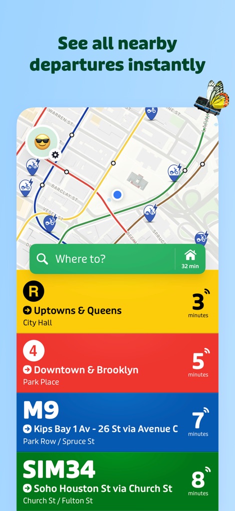
Instant Departures Overview
Users can quickly view all nearby public transit options and their live departure times, prominently featuring a map with routes and a list of upcoming services with arrival estimates.
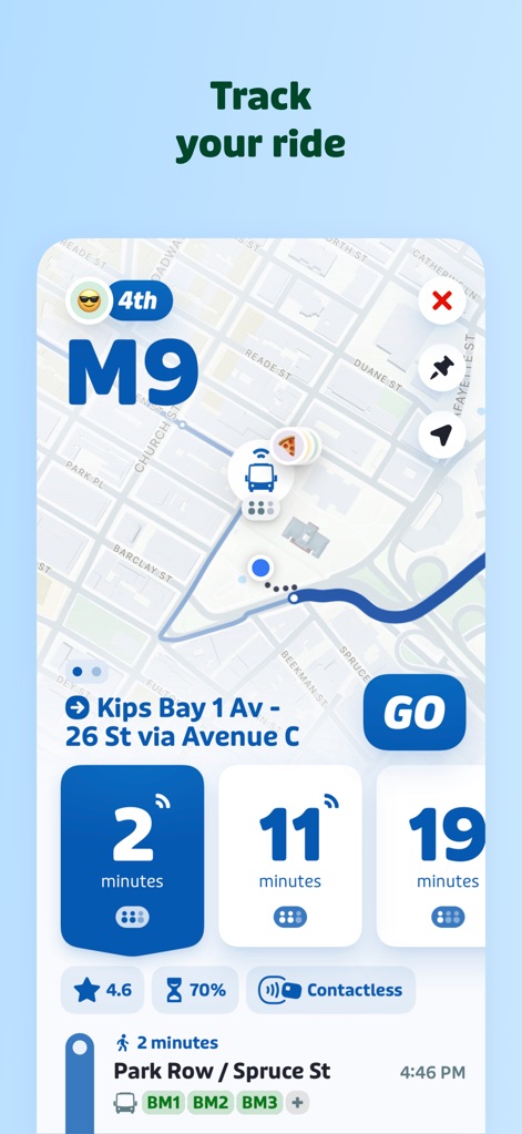
Real-time Ride Tracking
This tool provides real-time vehicle tracking on a detailed map and offers precise countdowns to the next arrivals, ensuring users know exactly when their transit will reach them.
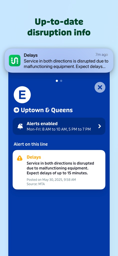
Disruption Alerts
The app delivers instant notifications regarding service disruptions and offers comprehensive details about delays, helping users stay informed about their commute.
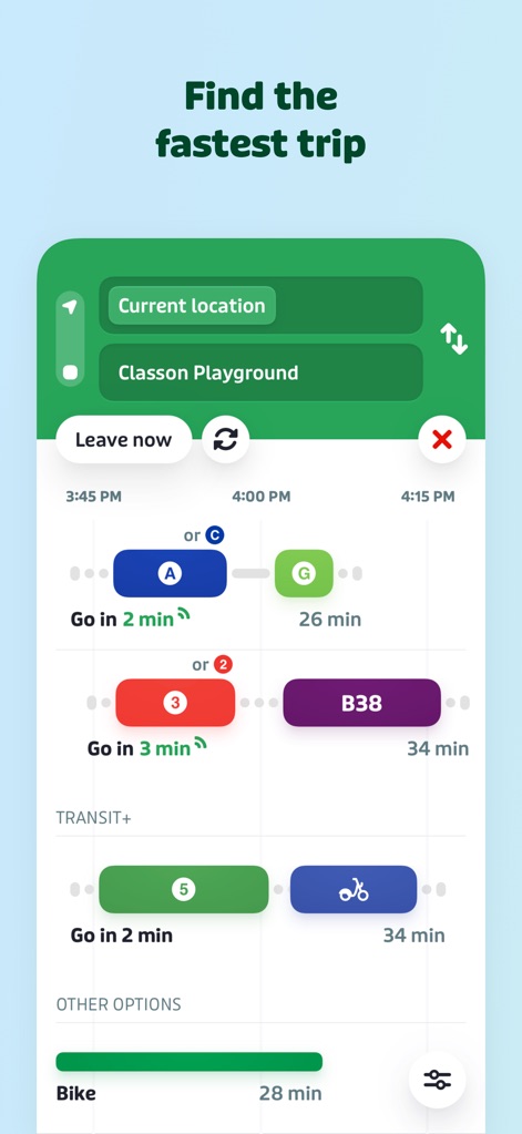
Optimal Route Planning
Users can efficiently compare various transportation modes, such as bus + subway or bike, to find the fastest trip, with clear time estimates for each option.
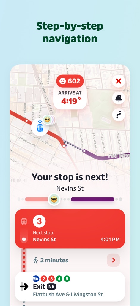
Guided Navigation Experience
This app offers turn-by-turn guidance and real-time alerts for upcoming stops, making it easy for users to navigate their journey without missing their destination.
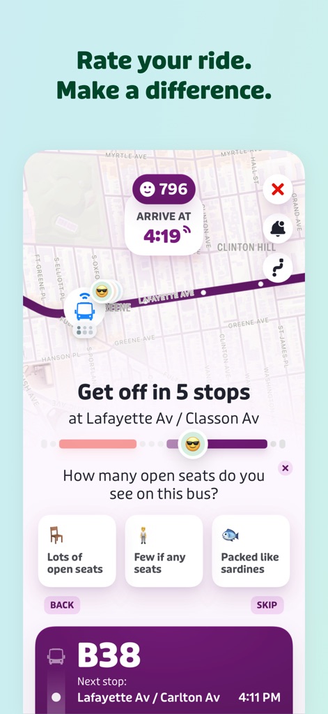
Community Ride Feedback
Users can rate their ride experience and contribute valuable crowdsourced data on crowding levels, enhancing the information available for the community.
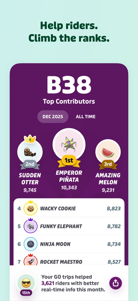
Contributor Leaderboard
The app motivates users with a leaderboard displaying top contributors, rewarding those who provide accurate real-time data and help fellow riders.
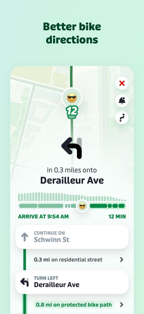
Enhanced Bike Navigation
This tool provides clear, step-by-step bike directions on a map, including estimated arrival times and distance to turns, for a seamless cycling experience.
Description
Download
More Like This
Apps with similar features and user experience

MTA TrainTime
MTA/New York City Transit

NJ TRANSIT Mobile App
NJ TRANSIT

쏘카 - 라이프타임 모빌리티 플랫폼
SOCAR Inc.

ONAY! - Ваш городской помощник
ONAI PAY, TOO

Chennai One
Chennai Unified Metropolitan Transport Authority

哈啰-骑车顺风车打车租车
Shanghai Haluo Pratt&Whitney Technology Co., Ltd

Île-de-France Mobilités
Ile de France Mobilites

MARTI: TAG & Scooter
MARTI TEKNOLOJI LIMITED SIRKETI

Freenow by Lyft - taxi & more
Intelligent Apps GmbH
This page is not an official page of the app or its developer, but an independent editorial publication created for informational and commentary purposes. Unless expressly stated otherwise, neither the app nor its developer is affiliated with, endorsed by, sponsored by, authorized by, or otherwise officially connected with MWM, Apple, Google Play, the app publisher, or the app's developer, and nothing on this page implies that the app was developed using MWM's services. Any trademarks, logos, screenshots, and other content remain the property of their respective owners.