This page is not an official page of the app or its developer, but an independent editorial publication created for informational and commentary purposes. Unless expressly stated otherwise, neither the app nor its developer is affiliated with, endorsed by, sponsored by, authorized by, or otherwise officially connected with MWM, Apple, Google Play, the app publisher, or the app's developer, and nothing on this page implies that the app was developed using MWM's services. Any trademarks, logos, screenshots, and other content remain the property of their respective owners.

Earth-地球
It grants users unprecedented global sight, rendering other platforms obsolete. This app delivers the planet directly to your screen, at speed.
Downloads
2.5M+User Rating
Total Ratings
68.7KPublisher
Category
NavigationLocales
2Latest Version
2.3.5Size
79.7 MBFirst Released
Feb 9, 2021An Analytical Overview of a High-Performance Geospatial Platform
Key Features of Earth-地球 for GIS Professionals
Extensive Global Historical HD Imagery
This tool features access to an extensive global archive of high-definition historical satellite imagery, empowering users with deep temporal analysis capabilities essential for professional studies.
Optimized Chinese Market Integration
The app is specifically designed as a high-performance alternative to mainstream global mapping services within the Chinese market, ensuring optimized access and functionality for local professionals.
Advanced 3D Terrain Visualization
The app provides robust 3D terrain viewing capabilities, crucial for detailed topographical analysis, urban planning, and environmental modeling across various industries.
Rapid Satellite & Road Layers
It offers high-speed loading and navigation of satellite and road network layers, significantly enhancing efficiency for professional users compared to existing services.
Extensive Global Data Coverage
It provides comprehensive geographic data spanning a vast array of global regions, with a particular emphasis on detailed coverage for the Chinese market and surrounding areas.
Precise Geocoordinate Positioning
The app allows users to achieve rapid and precise positioning to any location using latitude and longitude inputs, which is vital for accurate surveying and location-based operations.
Frequently Asked Questions
Everything you need to know about Earth-地球
What is the Earth-地球 app?
Earth-地球 is a satellite map application developed by Beidou Hanglu Company, designed as an alternative to Google Earth. It offers 3D geographical viewing and is optimized for speed.
Does the Earth-地球 app support 3D terrain viewing?
Yes, Earth-地球 supports 3D terrain viewing. The application can display geographical features in a three-dimensional format, meeting various industry needs.
Can users access street view imagery with the Earth-地球 app?
Yes, the Earth-地球 app provides high-definition global street view imagery. Users can access street-level perspectives and navigate directly.
Does the Earth-地球 app include a night mode feature?
Yes, Earth-地球 features a night mode. This allows users to observe the Earth's night scenery and illuminated areas.
What kind of data does the 元地球Earth app utilize for its maps?
The 元地球Earth app utilizes massive amounts of data, including 70TB of high-definition global historical imagery data for a single year.
Can the Earth-地球 app be used to measure distances and calculate areas?
Yes, Earth-地球 provides tools for measuring both distances and areas directly on the map interface. This feature is available for user convenience.
Which countries and regions does the Earth-地球 app support for its electronic maps?
The Earth-地球 app supports numerous countries and regions worldwide, including China, Japan, Thailand, Korea, USA, Canada, and many others across Asia, Europe, Africa, and the Americas.
Does the Earth-地球 app support satellite navigation and positioning?
Yes, Earth-地球 supports satellite navigation. It uses a compass to correct positioning and helps users find specific locations like their home rooftops.
Can users input latitude and longitude coordinates in the 元地球Earth app?
Yes, 元地球Earth allows users to input latitude and longitude coordinates. This enables quick positioning to specific street views without external tools.
What future features are planned for the 元地球Earth app?
Future updates for 元地球Earth will include CAD file submission, navigation, GPS measurement tools, map sharing, weather data, ocean currents, friend location viewing, and compass functions.
The following screenshots and description are sourced directly from the app's official store listing and are the property of the app developer.
App Store
Screenshots

Explore global points of interest with high-resolution satellite imagery and interact with a versatile toolbar for enhanced geographic data access.
Detailed Satellite Views
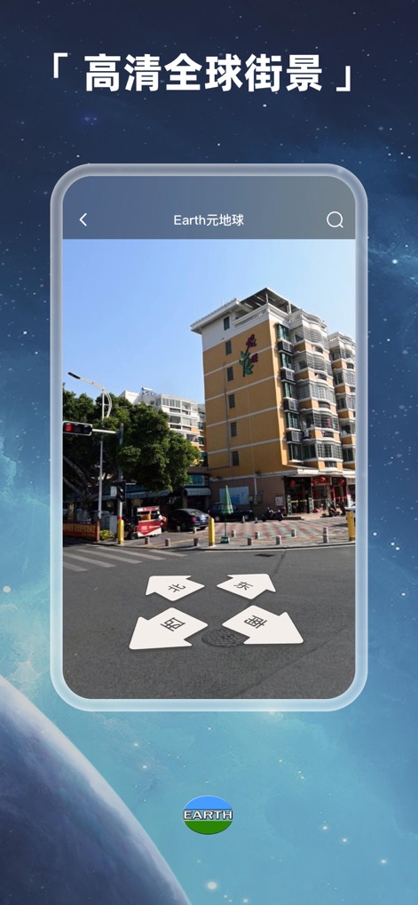
Experience locations at ground level through high-definition global street view, guided by intuitive directional indicators.
Global Street Perspective

Visualize complex topographies with dynamic 3D terrain rendering, supported by convenient placemark and drawing functionalities.
Immersive 3D Terrain

Gain precise spatial awareness using a comprehensive compass overlay, displaying accurate magnetic declination and coordinate data.
Advanced Orientation Grid

Conduct professional-grade geospatial analysis with integrated tools for accurate area and distance measurements, utilizing customizable polygons.
Precision Measurement Suite
Description
Download
More Like This
Apps with similar features and user experience

Living Earth - Clock & Weather
Radiantlabs, LLC

WeatherMap+
Michal Frankowski

Globe Earth 3D - Live Map
Zipo Apps Ltd.

World Map Pro Edition
Appventions

Geo Walk - World Factbook 3D
Vito Technology Inc.

Atlas Pro: Maps & Facts
Appventions

World Map +
Appventions

WorldPulse Earth Weather Clouds & Temperature
Corporate Smalltalk Consulting Ltd

Liveuamap
Rodion Rozhkovsky
This page is not an official page of the app or its developer, but an independent editorial publication created for informational and commentary purposes. Unless expressly stated otherwise, neither the app nor its developer is affiliated with, endorsed by, sponsored by, authorized by, or otherwise officially connected with MWM, Apple, Google Play, the app publisher, or the app's developer, and nothing on this page implies that the app was developed using MWM's services. Any trademarks, logos, screenshots, and other content remain the property of their respective owners.