This page is not an official page of the app or its developer, but an independent editorial publication created for informational and commentary purposes. Unless expressly stated otherwise, neither the app nor its developer is affiliated with, endorsed by, sponsored by, authorized by, or otherwise officially connected with MWM, Apple, Google Play, the app publisher, or the app's developer, and nothing on this page implies that the app was developed using MWM's services. Any trademarks, logos, screenshots, and other content remain the property of their respective owners.

MGP Ríos
Access real-time river levels, historical trends, and seasonal insights directly from the Peruvian Navy to ensure safe navigation and informed decision-making.
Downloads
1k+User Rating
Total Ratings
0Publisher
Category
NewsLocales
1Latest Version
4.6.2Size
46.5 MBFirst Released
Oct 5, 2016Navigate the Amazon with Precision and Authority
The essential hydrological tool for researchers, logistics professionals, and specialized stakeholders monitoring the Peruvian Amazon basin.
Daily River Metrics
Access real-time water level readings from the primary river systems across the Amazonian territory to mitigate operational risks.
Comparative Analytics
Visualize daily variations alongside historical maximums and minimums to identify critical patterns and seasonal climate trends.
The following screenshots and description are sourced directly from the app's official store listing and are the property of the app developer.
App Store
Screenshots

mgp-rios-app-main-menu
Main menu of the MGP Rios app for monitoring Amazonian river levels

mgp-rios-river-levels-monitoring
Mobile interface of MGP Rios app showing a list of Amazonian river levels and monitoring trends
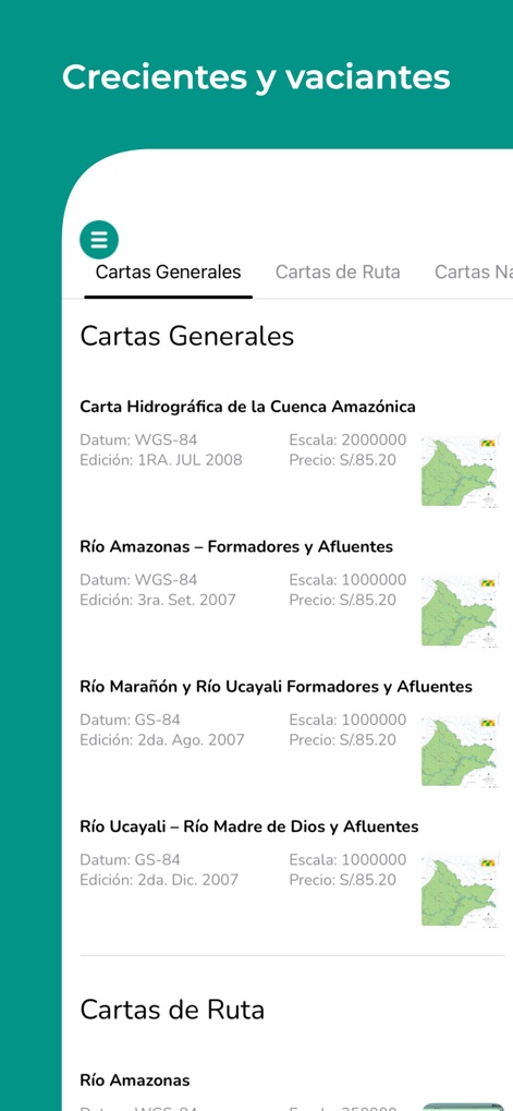
mgp-rios-amazon-hydrographic-charts
Interface of the MGP Rios app displaying a list of hydrographic charts for the Amazon basin with technical specifications and pricing

mgp-rios-amazon-river-list
List of Amazonian rivers monitored by the Peruvian Navy in the MGP Rios app interface
Description
Download
More Like This
Top-ranked apps in the same category

X
X Corp.

REDDIT, INC.

Substack
Substack Inc.

NYTimes: US and Global News
The New York Times Company

Nextdoor: Neighborhood Network
Nextdoor.com, Inc.

CrimeRadar Dispatch Audio
Scoopz Inc.

NewsBreak: Local News & Alerts
Particle Media Inc.

Ground News
Snapwise Inc.

Google News
Google LLC
This page is not an official page of the app or its developer, but an independent editorial publication created for informational and commentary purposes. Unless expressly stated otherwise, neither the app nor its developer is affiliated with, endorsed by, sponsored by, authorized by, or otherwise officially connected with MWM, Apple, Google Play, the app publisher, or the app's developer, and nothing on this page implies that the app was developed using MWM's services. Any trademarks, logos, screenshots, and other content remain the property of their respective owners.