This page is not an official page of the app or its developer, but an independent editorial publication created for informational and commentary purposes. Unless expressly stated otherwise, neither the app nor its developer is affiliated with, endorsed by, sponsored by, authorized by, or otherwise officially connected with MWM, Apple, Google Play, the app publisher, or the app's developer, and nothing on this page implies that the app was developed using MWM's services. Any trademarks, logos, screenshots, and other content remain the property of their respective owners.
NOAA Weather Radar Live Map
Weather is no longer a surprise. The app hands users the power of foresight against nature's fury.
Downloads
750k+User Rating
Total Ratings
13.1KPublisher
Category
WeatherLocales
12Latest Version
42.4Size
519.9 MBFirst Released
Jan 9, 2024An analytical overview of features vital for severe weather tracking, planning, and safety-conscious users.
NOAA Weather Radar Live Map: Core Capabilities Review
Real-time Severe Weather Alerts
The app provides timely notifications for critical weather events like tornadoes, hurricanes, and wildfires, enabling proactive safety measures and planning.
Interactive Radar & Layered Maps
This tool features animated radar and various map layers (e.g., rainfall, wind, humidity, satellite, hybrid) with customizable opacity and speed, offering detailed visual tracking of weather patterns.
Precise Hourly & Extended Forecasts
It allows users to access highly accurate hourly (24-hour) and extended (7+ day) forecasts, including minute-by-minute precipitation updates, crucial for planning activities and mitigating risks.
Extensive Weather Data Metrics
The app provides a wide array of detailed weather metrics, including temperature, humidity, wind speed/direction, UV index, pressure, and precipitation, supporting informed decision-making.
Worldwide Weather Coverage
This tool offers accurate forecasts for thousands of cities globally, along with localization options for time and language, making it versatile for international use and travel.
Convenient Home Screen Widgets
It allows users to quickly view essential weather information and severe weather alerts directly from their home screen via customizable widgets, ensuring constant awareness without opening the app.
Frequently Asked Questions
Everything you need to know about NOAA Weather Radar Live Map
What is NOAA Weather Radar Live Map?
NOAA Weather Radar Live Map is a weather forecast application providing real-time reports, hourly and daily forecasts, precipitation, and temperature information. It offers detailed current conditions, weather maps with various layers, and radar animations for global coverage.
Does NOAA Weather Radar Live Map provide severe weather alerts?
Yes, NOAA Weather Radar Live Map provides bad weather warnings and alerts for events like tornadoes, hurricanes, freeze warnings, ice, snow depth, wildfires, and lightning. It notifies users about severe weather in their area.
Can I track hurricanes with the NOAA Weather Radar Live Map app?
Yes, NOAA Weather Radar Live Map allows users to track a hurricane's past and projected path. It provides detailed information to help users prepare for severe storms and hurricane season.
How far in advance does NOAA Weather Radar Live Map forecast weather?
NOAA Weather Radar Live Map provides hourly forecasts for up to 24 hours and offers 7+-day hourly forecasts. It also displays a 14-day hourly forecast for specific locations, as seen in the app.
Does NOAA Weather Radar Live Map offer weather widgets?
Yes, NOAA Weather Radar Live Map offers weather widgets. These widgets allow users to easily get detailed temperature forecasts and severe weather alerts directly on their phone's notification display.
What weather map layers are available in NOAA Weather Radar Live Map?
NOAA Weather Radar Live Map offers various weather map layers, including basic and advanced precipitation forecasts, temperature, wind animation, snow depth forecast, and fires and hotspots. Users can also adjust loop speed.
Can NOAA Weather Radar Live Map provide real-time precipitation updates?
Yes, NOAA Weather Radar Live Map provides live weather forecasts with minute-by-minute precipitation updates. This helps users stay informed about immediate changes in rainfall.
What kind of weather details does the 'Today' module show in NOAA Weather Radar Live Map?
The 'Today' module in NOAA Weather Radar Live Map displays sunrise/sunset times, detailed weather information, air quality, health & life index, probability of rainfall, and wind conditions.
Does NOAA Weather Radar Live Map cover locations worldwide?
Yes, NOAA Weather Radar Live Map offers worldwide coverage. It provides local and global weather information, accurately tracking thousands of cities across the globe.
Is there an option to change the map type in NOAA Weather Radar Live Map?
Yes, NOAA Weather Radar Live Map provides options for different map types. Users can select between Standard Map, Satellite Map, and Hybrid Map views within the application.
The following screenshots and description are sourced directly from the app's official store listing and are the property of the app developer.
App Store
Screenshots
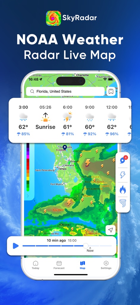
Users can observe real-time weather conditions on an interactive map, complete with detailed hourly forecasts and instant severe weather indicators.
Live Weather Overview
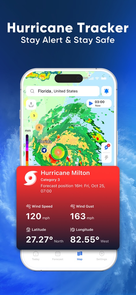
This tool provides a dedicated hurricane tracker displaying crucial details like wind speed and gust, along with the hurricane's forecast position on the map.
Hurricane Tracking Dashboard
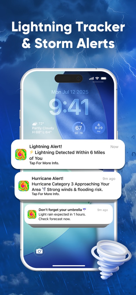
The app delivers timely notifications for severe weather events such as lightning alerts and approaching hurricanes, keeping users informed directly on their device.
Instant Weather Alerts
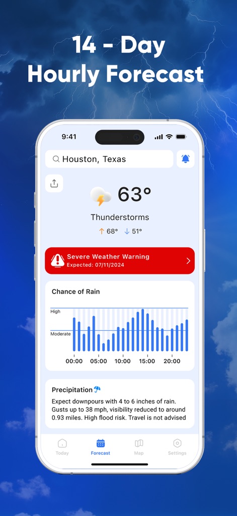
Users gain access to a comprehensive 14-day hourly forecast, featuring precise temperature predictions and a visual chance of rain graph for planning.
Extended Hourly Forecast
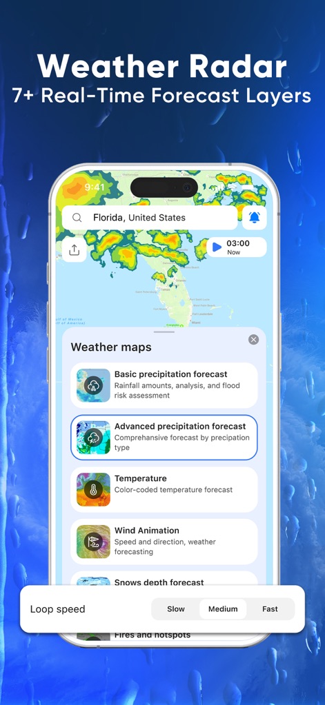
This tool offers diverse weather map options, including detailed precipitation forecasts and dynamic wind animations, all with adjustable loop speeds for comprehensive analysis.
Advanced Radar Layers
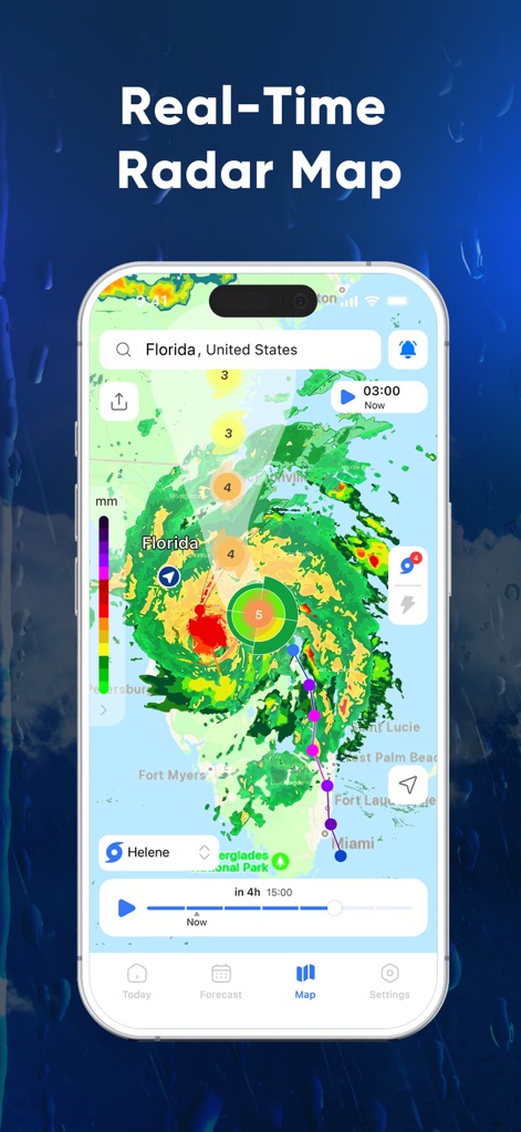
The app presents a high-definition real-time radar map, allowing users to visualize storm systems and track their progression using the intuitive time slider.
Dynamic Radar View
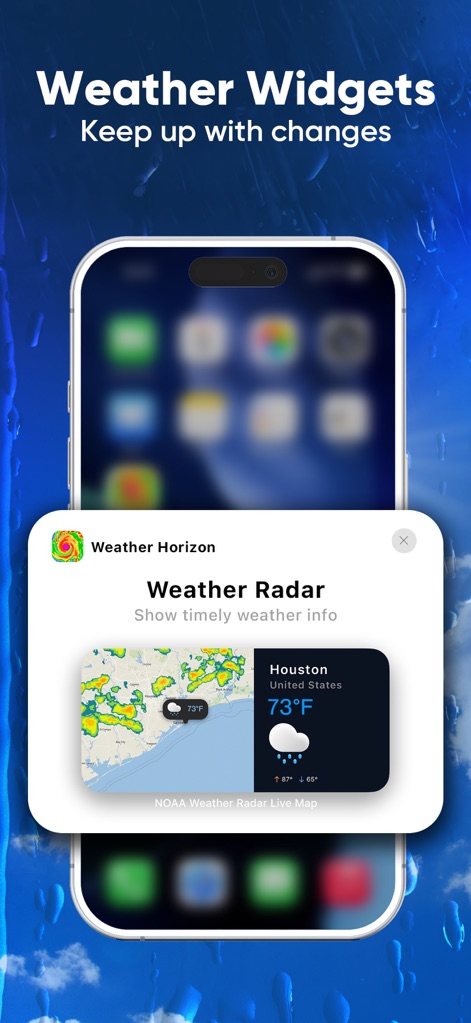
Users can utilize customizable weather widgets to get quick updates on current conditions and radar snapshots directly from their home screen.
Convenient Weather Widgets
Description
Download
More Like This
Apps with similar features and user experience

墨迹天气-MojiWeather
Beijing MojiFengyun Technology Co.,Ltd.

Windy.com
Windyty, SE

天气通
Weibo Internet Technology (China) Co.Ltd.

Zoom Earth - Weather Forecast
Neave Interactive Limited

实时天气-40日精准天气实时预报
犇 牛

MyRadar Accurate Weather Radar
Aviation Data Systems, Inc

Ventusky: Weather & Live Radar
Ventusky s.r.o.

FOX Weather: Daily Forecasts
Fox News Network, LLC

2345天气王-天气和空气质量查询小组件
Shanghai 2345 Network Technology Co., Ltd.
This page is not an official page of the app or its developer, but an independent editorial publication created for informational and commentary purposes. Unless expressly stated otherwise, neither the app nor its developer is affiliated with, endorsed by, sponsored by, authorized by, or otherwise officially connected with MWM, Apple, Google Play, the app publisher, or the app's developer, and nothing on this page implies that the app was developed using MWM's services. Any trademarks, logos, screenshots, and other content remain the property of their respective owners.