This page is not an official page of the app or its developer, but an independent editorial publication created for informational and commentary purposes. Unless expressly stated otherwise, neither the app nor its developer is affiliated with, endorsed by, sponsored by, authorized by, or otherwise officially connected with MWM, Apple, Google Play, the app publisher, or the app's developer, and nothing on this page implies that the app was developed using MWM's services. Any trademarks, logos, screenshots, and other content remain the property of their respective owners.

Zoom Earth - Weather Forecast
Experience the power of professional meteorology with stunning interactive maps and live satellite imagery. From tracking major hurricanes to monitoring wildfires, stay informed and prepared with data updated every 10 minutes.
Downloads
2M+User Rating
Total Ratings
122K+Publisher
Category
WeatherLocales
14Latest Version
5.0.1Size
52.3 MBFirst Released
Jun 27, 2023Visual Intelligence for a Changing World
Experience the most advanced interactive weather map, combining high-definition satellite imagery with professional-grade tracking tools to keep you one step ahead of the elements.
Near Real-Time Satellite Feed
Observe global weather patterns as they evolve with HD imagery updated every 10 minutes from NOAA and NASA satellites, bringing raw data directly to your screen.
Precision Hazard Tracking
Protect your home and family by monitoring hurricanes, wildfires, and severe storms with the same data used by meteorological professionals and emergency responders.
Frequently Asked Questions
Everything you need to know about Zoom Earth - Weather Forecast
What is Zoom Earth - Weather Forecast?
Zoom Earth is an interactive weather map and real-time hurricane tracker, providing forecasts for rain, wind, temperature, pressure, and more across the world.
Does Zoom Earth provide real-time weather information?
Yes, Zoom Earth provides near real-time satellite imagery updated every 10 minutes and real-time rain/snow detection via ground-based Doppler radar with nowcasting.
Can Zoom Earth track hurricanes in real-time?
Yes, Zoom Earth tracks hurricanes from development to category 5 in real-time. It updates using the latest data from NHC, JTWC, NRL, and IBTrACS.
Does Zoom Earth show wildfires?
Yes, Zoom Earth monitors wildfires with an active fires and heat spots overlay, updated daily with data from NASA FIRMS. It also shows wildfire smoke movement.
What weather forecast maps are available in Zoom Earth?
Zoom Earth offers forecast maps for precipitation, wind speed, wind gusts, temperature, "feels like" temperature, relative humidity, dew point, and atmospheric pressure.
How does the Zoom Earth PRO subscription work?
Zoom Earth PRO offers additional features via auto-renewable subscriptions. Payment is charged to your App Store account and renews automatically unless turned off 24 hours prior.
Can I customize settings in Zoom Earth?
Yes, Zoom Earth allows customization of temperature units, wind units, time zone, and animation styles through its comprehensive settings.
How often is the satellite imagery updated in Zoom Earth?
Live satellite images are updated every 10 or 15 minutes, depending on the satellite source. HD satellite images are updated twice a day.
Does Zoom Earth include a rain radar map?
Yes, Zoom Earth features a weather radar map displaying real-time rain and snow detected by ground-based Doppler radar. It provides instant short-term weather forecasts.
Can I see wind speed information on Zoom Earth?
Yes, Zoom Earth provides detailed wind speed forecast maps showing average speed and direction of surface winds, along with wind gusts forecast information.
The following screenshots and description are sourced directly from the app's official store listing and are the property of the app developer.
App Store
Screenshots
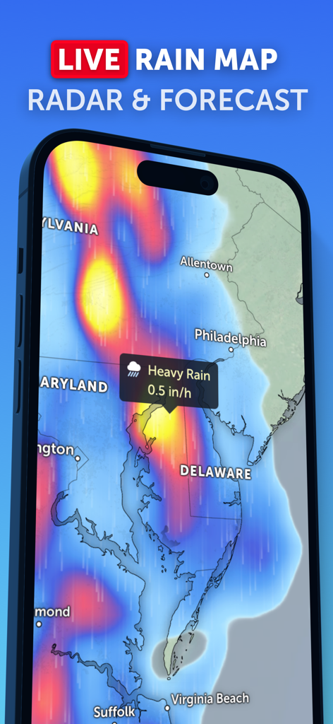
Zoom Earth app showing a live rain map with radar forecast and heavy rain alerts over the East Coast.
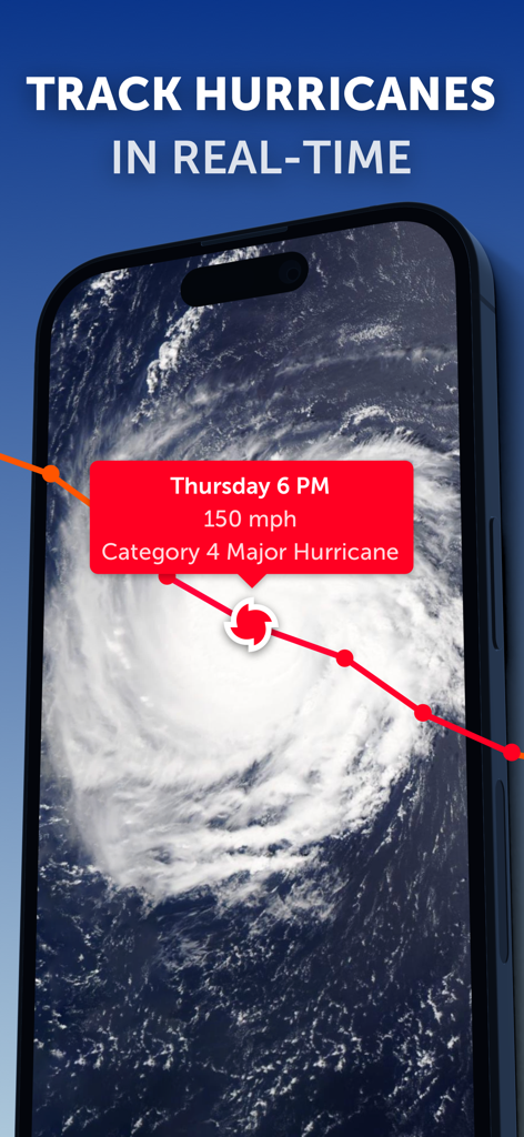
Zoom Earth app interface displaying real-time satellite tracking and data for a Category 4 hurricane.
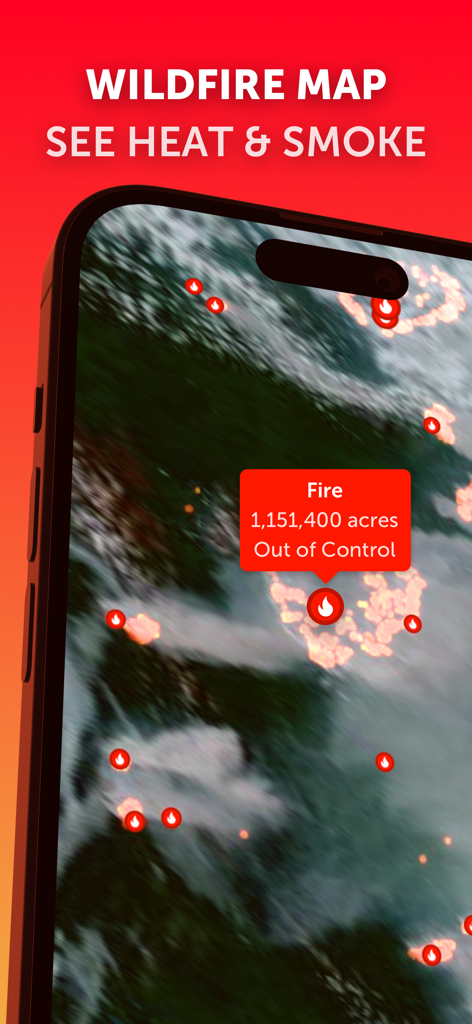
Zoom Earth app showing a real-time wildfire map with heat spots and out of control fire data
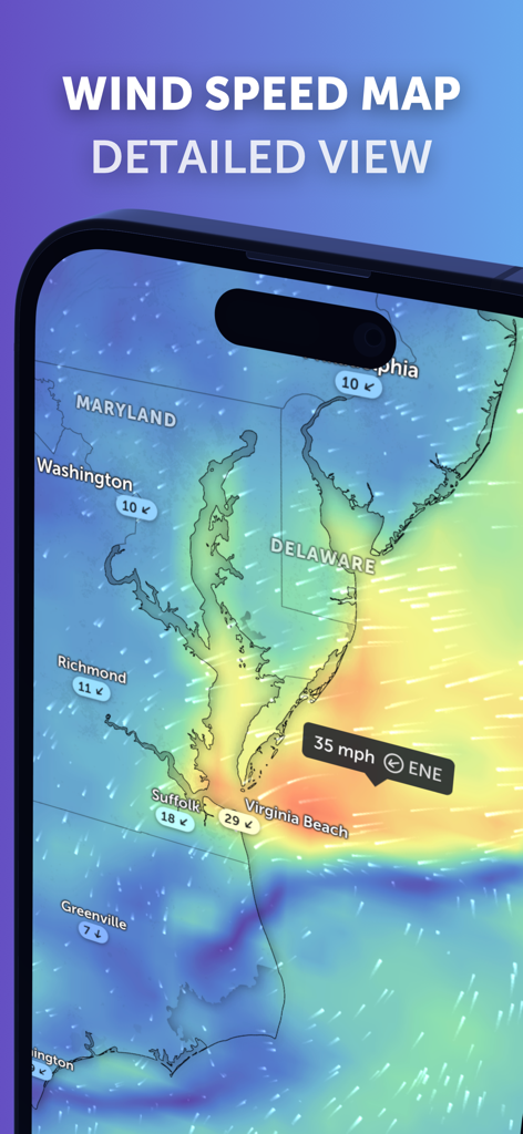
A detailed wind speed forecast map showing current conditions over Maryland and Virginia on the Zoom Earth mobile app interface.
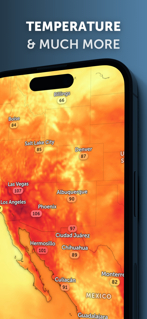
Zoom Earth app displaying a temperature heat map of North America on a smartphone.
Description
Download
More Like This
Apps with similar features and user experience

墨迹天气-MojiWeather
Beijing MojiFengyun Technology Co.,Ltd.

Windy.com
Windyty, SE

天气通
Weibo Internet Technology (China) Co.Ltd.

实时天气-40日精准天气实时预报
犇 牛

MyRadar Accurate Weather Radar
Aviation Data Systems, Inc

Ventusky: Weather & Live Radar
Ventusky s.r.o.

FOX Weather: Daily Forecasts
Fox News Network, LLC

2345天气王-天气和空气质量查询小组件
Shanghai 2345 Network Technology Co., Ltd.

Weather & Widget - Weawow
weawow Inc.
This page is not an official page of the app or its developer, but an independent editorial publication created for informational and commentary purposes. Unless expressly stated otherwise, neither the app nor its developer is affiliated with, endorsed by, sponsored by, authorized by, or otherwise officially connected with MWM, Apple, Google Play, the app publisher, or the app's developer, and nothing on this page implies that the app was developed using MWM's services. Any trademarks, logos, screenshots, and other content remain the property of their respective owners.