This page is not an official page of the app or its developer, but an independent editorial publication created for informational and commentary purposes. Unless expressly stated otherwise, neither the app nor its developer is affiliated with, endorsed by, sponsored by, authorized by, or otherwise officially connected with MWM, Apple, Google Play, the app publisher, or the app's developer, and nothing on this page implies that the app was developed using MWM's services. Any trademarks, logos, screenshots, and other content remain the property of their respective owners.

onX Offroad: Trail Maps & GPS
No signal? No problem. This app gives you the digital backbone to conquer the backcountry.
Downloads
5M+User Rating
Total Ratings
8.3KPublisher
Category
NavigationLocales
1Latest Version
26.13.0Size
724.1 MBFirst Released
Nov 4, 2019An analytical overview of the core functionalities that empower off-road adventurers with advanced navigation and planning tools.
Key Features of onX Offroad: Trail Maps & GPS
Offline Maps & GPS Navigation
The app provides robust offline map capabilities, enabling users to download interactive land and trail data for seamless GPS navigation even without cellular service, which is essential for remote off-road exploration.
Detailed Trail & Land Data Layers
This tool features comprehensive map layers including 3D trail maps, high-definition topography, satellite imagery, and critical information such as private property boundaries, public land designations (National Forest, BLM), and land access details, ensuring informed and legal navigation.
Vehicle-Specific Trail Filtering
It allows users to filter trails by accessibility for various vehicle types, including 4x4, SxS, dirt bikes, ATVs, and snowmobiles, ensuring they find routes suitable for their specific mode of transport and skill level.
Dispersed Camping & POI Discovery
The app helps users discover legal, free dispersed camping spots in National Forests using USFS verified data, alongside points of interest like trailheads, parking, and non-ethanol fuel stations, streamlining trip planning for overlanders and campers.
Cell Coverage & Environmental Data
This tool integrates Cell Coverage Layers for major carriers (AT&T, Verizon, T-Mobile) and NOAA’s Atmospheric Smoke Forecast data, providing vital safety information for communication and assessing environmental conditions before and during trips.
Custom Route Planning & Tracking
It enables users to plan custom routes that automatically snap to existing roads and trails, as well as track their distance, location, speed, and elevation, offering comprehensive trip management and post-adventure analysis.
Frequently Asked Questions
Everything you need to know about onX Offroad: Trail Maps & GPS
What does the onX Offroad app do?
The onX Offroad app provides off-road trail maps, GPS mapping, and compass navigation. It helps users discover trails, identify open areas, and explore new routes for various off-road activities.
Can I filter trails by vehicle type in onX Offroad?
Yes, onX Offroad allows users to filter trails by accessibility for 4x4, SxS, dirt bikes, moto, ATV/Quads, Overland, and snowmobiles.
How does onX Offroad help find dispersed camping?
onX Offroad features a Motorized Dispersed Camping Layer using USFS verified data. It identifies legal, free off-grid camping areas in National Forests.
Does onX Offroad show private property lines?
Yes, onX Offroad provides property lines and private landowner information across the nation. This feature is limited by membership.
Can I see cell service coverage with onX Offroad?
Yes, onX Offroad includes AT&T, Verizon, and T-Mobile coverage maps. This helps users know where they will have cell service while off-roading.
Does onX Offroad offer offline maps?
Yes, onX Offroad allows users to save Offline Maps to their phone or tablet. This enables navigation without cell service, retaining interactive land and trail data.
Is onX Offroad compatible with Apple CarPlay?
Yes, onX Offroad offers turn-by-turn navigation and can sync with Apple CarPlay for in-vehicle display and control.
What map layers are available in the onX Offroad app?
onX Offroad offers various map layers, including weather, land boundaries, cell service, active wildfires, and wildfire smoke data.
Does onX Offroad help monitor wildfires?
Yes, onX Offroad monitors wildfires and drifting smoke with data from the NIFC and NOAA. This feature helps users anticipate poor air quality.
What features do onX Offroad memberships include?
Memberships include access to over 650K miles of motorized trails, 852M acres of public land, 24K topographic and 3D maps, and the ability to save Offline Maps.
Does onX Offroad offer a free trial?
Yes, onX Offroad offers a free trial when users install the app. This allows experience with its premium off-roading tools.
Does onX Offroad support 3D map views?
Yes, onX Offroad supports 3D map modes for visualizing terrain. Users can choose from 3D, topo, satellite, or hybrid map imagery.
Can onX Offroad display recent satellite imagery?
Yes, onX Offroad provides recent imagery to check trail and terrain conditions via satellite. Users can select imagery by date.
Does onX Offroad identify public lands?
Yes, onX Offroad identifies various public lands, including National Forests, BLM land, and National Parks. This helps users navigate and understand land ownership.
What navigation features does onX Offroad provide?
onX Offroad offers GPS navigation, turn-by-turn directions with voice commands, a route builder, and trip tracking for distance, location, speed, or elevation.
The following screenshots and description are sourced directly from the app's official store listing and are the property of the app developer.
App Store
Screenshots

The app provides detailed trail maps, allowing users to discover open trails and view their difficulty ratings and estimated travel times.
Trail Discovery Tools

Users can easily identify areas with strong cellular signal through color-coded map layers and consult detailed coverage statistics for major carriers.
Cellular Coverage Map
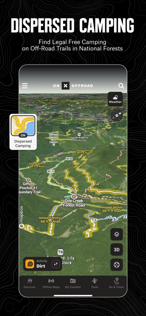
This tool helps users locate legal dispersed camping spots within National Forests, displaying relevant map layers and boundary information.
Camping Spot Locator

The app offers clear visualizations of private land ownership boundaries and provides detailed information, including coordinates for specific parcels.
Private Land Insights
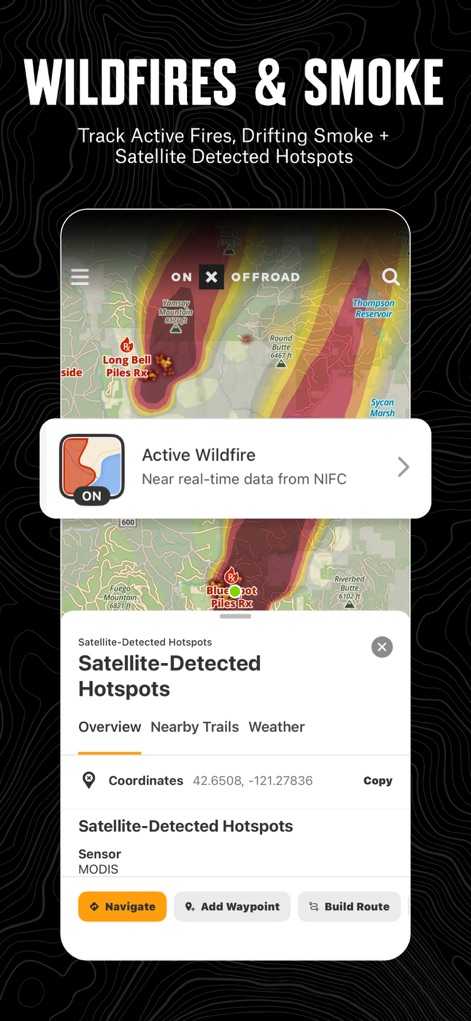
Users can track active wildfires and view satellite-detected hotspots, along with atmospheric smoke forecast data, to ensure safe navigation.
Wildfire Safety Layer

This feature allows users to save interactive trail data and GPS navigation areas for use without cell service, with an intuitive interface for creating and managing saved maps.
Offline Map Management
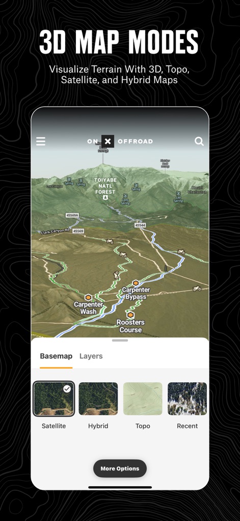
The app provides stunning 3D map modes for visualizing terrain, allowing users to switch between satellite, hybrid, and topographic basemaps for comprehensive views.
Immersive 3D Topography

Users can access recent satellite imagery to assess trail and terrain conditions, utilizing a date selection tool to compare different periods.
Historical Satellite Views

This tool assists users in navigating public lands like National Parks and Forests, displaying clear boundaries and various recreational waypoints.
Public Land Navigation

The app provides turn-by-turn navigation directly through Apple CarPlay, allowing users to follow saved routes conveniently on their vehicle's display.
Seamless CarPlay Integration
Description
Download
More Like This
Apps with similar features and user experience

Detecht - Motorcycle App & GPS
Detecht Technologies AB

REVER - Motorcycle GPS & Rides
Rever, LLC

NYSSA Snowmobile Trails
Mapgears Inc.

Scenic Motorcycle Navigation
Applified Life Ltd.

Trails Offroad: Offline Maps
TRAILS OFFROAD LLC

Overland Bound One: Maps & GPS
Overland Bound Inc

Stegra.io - Motorcycle GPS
Stegraio AB

GoSnowmobiling NB
Mapgears Inc.

Lost Riders
Lost Riders, LLC
This page is not an official page of the app or its developer, but an independent editorial publication created for informational and commentary purposes. Unless expressly stated otherwise, neither the app nor its developer is affiliated with, endorsed by, sponsored by, authorized by, or otherwise officially connected with MWM, Apple, Google Play, the app publisher, or the app's developer, and nothing on this page implies that the app was developed using MWM's services. Any trademarks, logos, screenshots, and other content remain the property of their respective owners.