This page is not an official page of the app or its developer, but an independent editorial publication created for informational and commentary purposes. Unless expressly stated otherwise, neither the app nor its developer is affiliated with, endorsed by, sponsored by, authorized by, or otherwise officially connected with MWM, Apple, Google Play, the app publisher, or the app's developer, and nothing on this page implies that the app was developed using MWM's services. Any trademarks, logos, screenshots, and other content remain the property of their respective owners.

Pacific Typhoon Tracker
Forewarned is forearmed. This app delivers the raw data needed to outmaneuver the storm's path.
Downloads
25k+User Rating
Total Ratings
16Publisher
Category
WeatherLocales
1Latest Version
6.3Size
3.3 MBFirst Released
Oct 9, 2015An analytical review of core functionalities for Atlantic Basin preparedness.
Software Evaluation: Pacific Typhoon Tracker
Hurricane Tracks
The app provides critical information on the projected paths of hurricanes, enabling users to make timely evacuation or preparedness decisions.
Tropical Storm Tracks
It allows users to monitor the trajectories of tropical storms, vital for assessing potential risks to coastal areas and maritime activities.
NHC Chance of Development
This tool features National Hurricane Center (NHC) data on the probability of new storm formation, offering early indicators for potential threats.
Tropical Depression Tracks
The app provides detailed tracking of tropical depressions, helping users understand the very early stages of storm development.
NOAA Buoy and Ship Observation Data
It delivers real-time meteorological observations from NOAA buoys and ships, providing accurate, localized weather conditions crucial for marine safety and planning.
Wave Height Data
This tool displays current wave height information, essential for mariners navigating dangerous waters and for coastal communities assessing surge risks.
Wave Direction
The app offers insights into wave direction, providing crucial data for maritime navigation and for understanding potential coastal impacts like erosion.
GPS Location
It integrates GPS functionality to center the map on the user's current location, making it easier to assess local storm impacts and proximity.
Global Cloud Cover
The app provides global cloud cover imagery, offering a comprehensive visual context of weather systems surrounding tropical disturbances.
Global Surface Winds
This tool displays global surface wind patterns, which are valuable for understanding storm movement and for marine forecasting.
The following screenshots and description are sourced directly from the app's official store listing and are the property of the app developer.
App Store
Screenshots
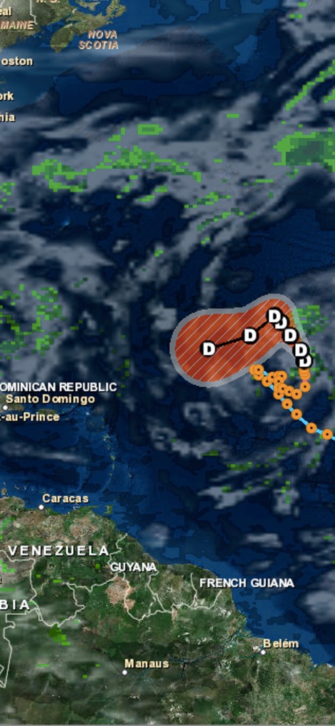
Observe how the app clearly displays tropical depression tracks and current global cloud cover across the Atlantic.
Real-time Tracking
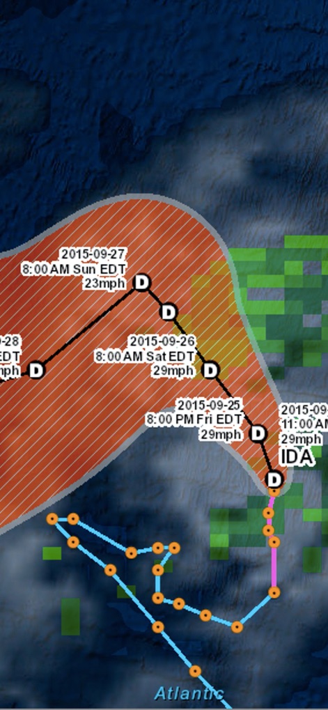
This tool presents comprehensive hurricane tracks, including future date-time stamps and predicted wind speeds, for precise planning.
Detailed Forecasts
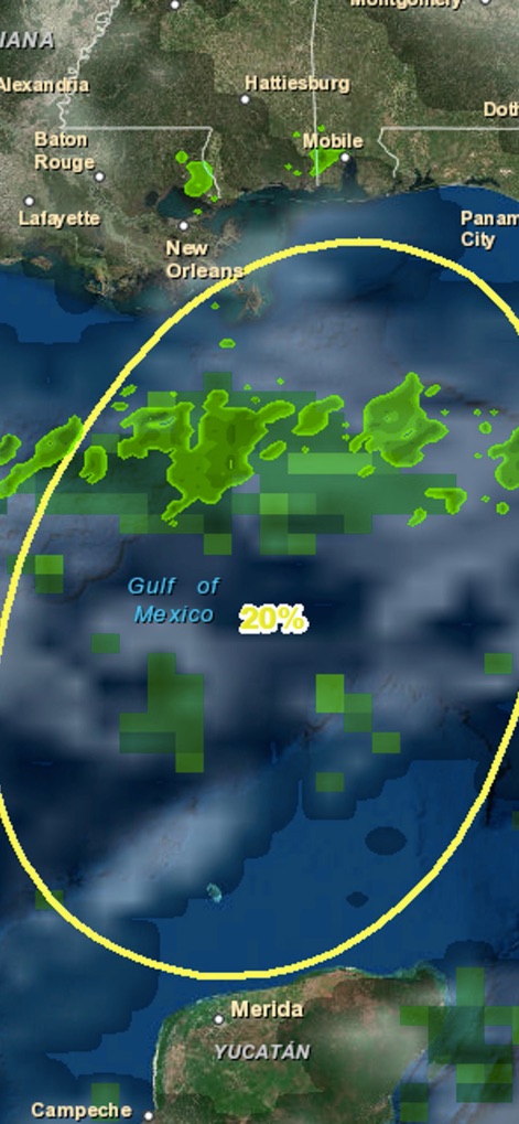
Users can evaluate the NHC Chance of Development with percentage indicators and layered 3-hour precipitation data over affected areas.
Development Probability
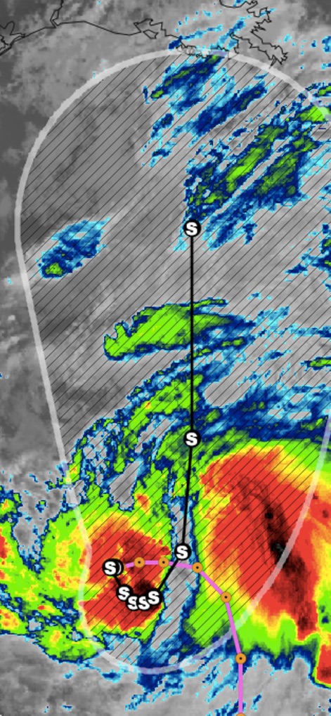
The app provides critical visual representations of tropical storm tracks overlaid on high-resolution satellite imagery, revealing intensity patterns.
Visual Storm Intensity
Description
Download
More Like This
Top-ranked apps in the same category

墨迹天气-MojiWeather
Beijing MojiFengyun Technology Co.,Ltd.

The Weather Channel - Radar
The Weather Channel

Windy.com
Windyty, SE

天气预报-精准15日天气预报
Chongqing Caochen Technology Co., Ltd.

My Aurora Forecast & Alerts
JRustonApps B.V.

AccuWeather: Weather Forecast
AccuWeather International, Inc.

Weather & Radar - Storm radar
WetterOnline - Meteorologische Dienstleistungen GmbH

天气通
Weibo Internet Technology (China) Co.Ltd.

The Thermometer -Digital-
Vida Apps Incorporated
This page is not an official page of the app or its developer, but an independent editorial publication created for informational and commentary purposes. Unless expressly stated otherwise, neither the app nor its developer is affiliated with, endorsed by, sponsored by, authorized by, or otherwise officially connected with MWM, Apple, Google Play, the app publisher, or the app's developer, and nothing on this page implies that the app was developed using MWM's services. Any trademarks, logos, screenshots, and other content remain the property of their respective owners.