This page is not an official page of the app or its developer, but an independent editorial publication created for informational and commentary purposes. Unless expressly stated otherwise, neither the app nor its developer is affiliated with, endorsed by, sponsored by, authorized by, or otherwise officially connected with MWM, Apple, Google Play, the app publisher, or the app's developer, and nothing on this page implies that the app was developed using MWM's services. Any trademarks, logos, screenshots, and other content remain the property of their respective owners.

ThaiWater
Protect your family, property, and business with direct access to Thailand's national hydro-informatics. Monitor dam levels, rainfall, and flood risks with precision data from anywhere in the world.
Downloads
105K+User Rating
Total Ratings
100Publisher
Category
WeatherLocales
1Latest Version
4.1.7Size
47.1 MBFirst Released
Apr 1, 2016Stay Informed with Thailand's Official Water Intelligence
Get direct access to the National Hydroinformatics Data Center for the most reliable, real-time insights on flood risks, dam levels, and rainfall across the country.
Hyper-Local Water Monitoring
Track real-time water levels in specific river basins and provinces to protect family property and anticipate flood risks long before they hit international news.
Critical Dam Capacity Data
Monitor storage levels in major dams nationwide to assess supply chain risks and environmental conditions, essential for business continuity and long-term planning.
The following screenshots and description are sourced directly from the app's official store listing and are the property of the app developer.
App Store
Screenshots
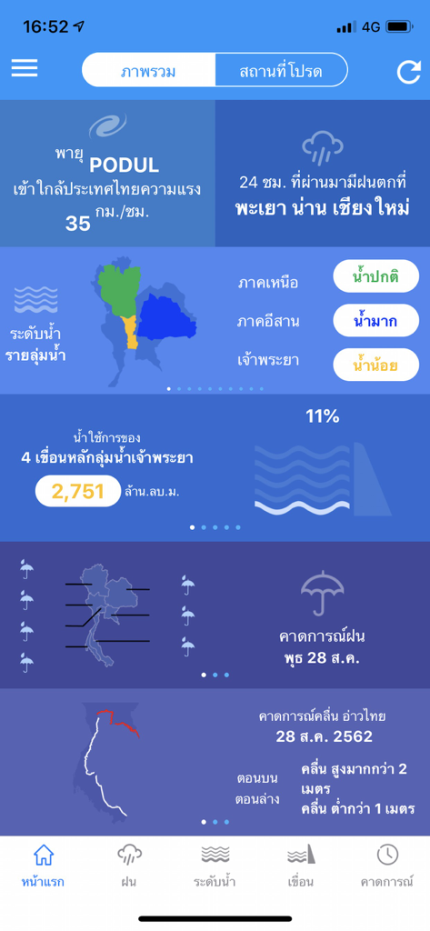
Dashboard of the ThaiWater app featuring storm tracking, rainfall data, and dam water levels in Thailand.
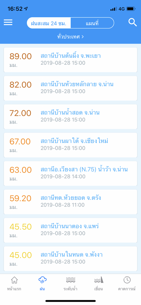
Screenshot of the ThaiWater mobile app displaying a list of 24-hour accumulated rainfall measurements in millimeters for different locations in Thailand.
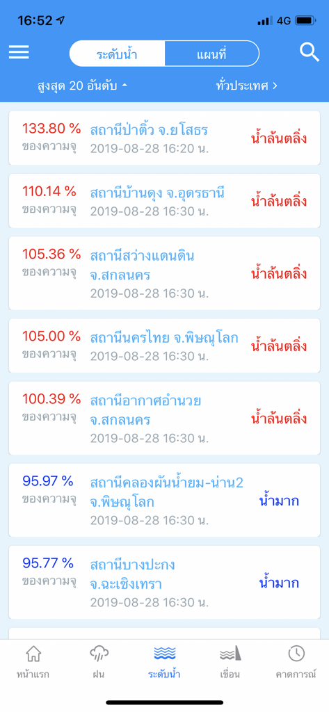
Interface of the ThaiWater app displaying a list of water level percentages and monitoring station names.
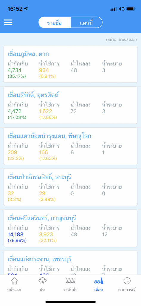
Screenshot of the ThaiWater mobile app displaying a list of dam water storage levels and statistics in Thai.
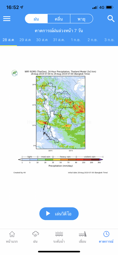
A 24-hour precipitation forecast map of Thailand on the ThaiWater mobile app showing rainfall intensity
Description
Download
More Like This
Top-ranked apps in the same category

墨迹天气-MojiWeather
Beijing MojiFengyun Technology Co.,Ltd.

The Weather Channel - Radar
The Weather Channel

Windy.com
Windyty, SE

天气预报-精准15日天气预报
Chongqing Caochen Technology Co., Ltd.

My Aurora Forecast & Alerts
JRustonApps B.V.

AccuWeather: Weather Forecast
AccuWeather International, Inc.

Weather & Radar - Storm radar
WetterOnline - Meteorologische Dienstleistungen GmbH

天气通
Weibo Internet Technology (China) Co.Ltd.

The Thermometer -Digital-
Vida Apps Incorporated
This page is not an official page of the app or its developer, but an independent editorial publication created for informational and commentary purposes. Unless expressly stated otherwise, neither the app nor its developer is affiliated with, endorsed by, sponsored by, authorized by, or otherwise officially connected with MWM, Apple, Google Play, the app publisher, or the app's developer, and nothing on this page implies that the app was developed using MWM's services. Any trademarks, logos, screenshots, and other content remain the property of their respective owners.