This page is not an official page of the app or its developer, but an independent editorial publication created for informational and commentary purposes. Unless expressly stated otherwise, neither the app nor its developer is affiliated with, endorsed by, sponsored by, authorized by, or otherwise officially connected with MWM, Apple, Google Play, the app publisher, or the app's developer, and nothing on this page implies that the app was developed using MWM's services. Any trademarks, logos, screenshots, and other content remain the property of their respective owners.

TroutRoutes: Fly Fishing App
Turn your next trip into a calculated adventure. Access 50,000+ mapped streams, definitive public land boundaries, and real-time flow data to fish with absolute confidence.
Downloads
726K+User Rating
Total Ratings
3K+Publisher
Category
NavigationLocales
1Latest Version
5.3.5Size
282.9 MBFirst Released
Mar 4, 2019The Ultimate Tactical Advantage for Every Angler
Spend less time scouting and more time casting with the industry-leading mapping tool built for precision, legal access, and real-time stream insights.
Master Public Access
Fish with total peace of mind using color-coded public and private land boundaries to navigate easements and avoid trespassing.
Real-Time Stream Intelligence
Know before you go with live USGS flow data and water level charts to ensure your chosen destination is in peak fishing condition.
Frequently Asked Questions
Everything you need to know about TroutRoutes: Fly Fishing App
What is TroutRoutes by onX?
TroutRoutes by onX is the #1 GPS mapping tool for trout streams and fly fishing, offering interactive maps, stream data, and navigation for over 50,000 trout streams across the continental U.S.
Does TroutRoutes help find fishing spots?
Yes, TroutRoutes helps users find local fishing spots and explore new waters with its proprietary mapping system, showing details like trail access, parking, and public access points.
How many trout streams are mapped in TroutRoutes?
TroutRoutes maps over 50,000 trout streams across 48 states in the continental United States. It provides comprehensive information for each stream and river, including habitat quality.
Can I use TroutRoutes offline?
Yes, TroutRoutes allows users to download detailed maps by river or region for offline use. This feature ensures functionality without cell service, and users can save custom markups.
Does TroutRoutes show real-time stream conditions?
Yes, TroutRoutes provides real-time stream conditions. It uses live data from stream gages to show flow rates, stream height, and water temperature for informed fishing decisions.
What is the cost of TroutRoutes PRO membership?
TroutRoutes PRO membership costs $58.99 per year. This plan includes access to all features across 48 states, 50,000 classified trout streams, and 280,000 custom access points.
Is there a free trial for TroutRoutes?
Yes, TroutRoutes offers a free PRO trial for seven days upon app installation. This trial unlocks public land parcels, classified trout streams, custom access points, and offline maps.
Can I get directions to fly fishing shops with TroutRoutes?
Yes, TroutRoutes helps users locate local fly fishing shops. The app provides shop locations, direct access to websites, and navigation directions for convenience.
Does TroutRoutes provide information on fishing regulations?
Yes, TroutRoutes includes a Regulations Map with color-coded fishing regulation sections for each state. It provides detailed river regulations to ensure compliance.
What types of access points does TroutRoutes identify?
TroutRoutes identifies various access points, including fishing easements, national forests, local parks, and boat ramps. It features over 280,000 hand-curated public access points.
Can I mark custom points of interest in TroutRoutes?
Yes, TroutRoutes enables users to create custom maps. Users can add private markups and notes for their points of interest, enhancing trip planning and tracking.
Does TroutRoutes offer a single-state membership?
Yes, TroutRoutes offers a Single-State Membership for $19.99 annually. This plan provides access to all PRO features, such as classified trout streams and custom access points, for a chosen state.
The following screenshots and description are sourced directly from the app's official store listing and are the property of the app developer.
App Store
Screenshots
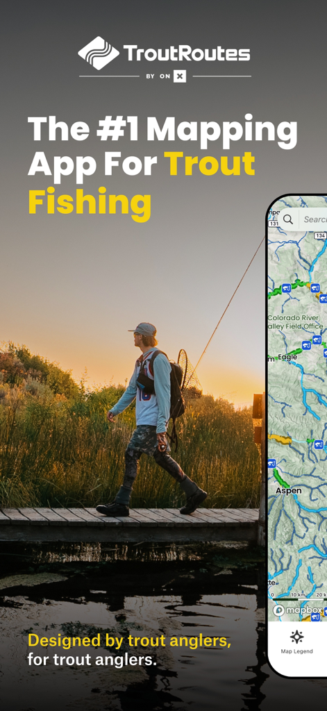
A fly fisherman walking across a bridge at sunset next to a smartphone displaying the TroutRoutes fishing map app
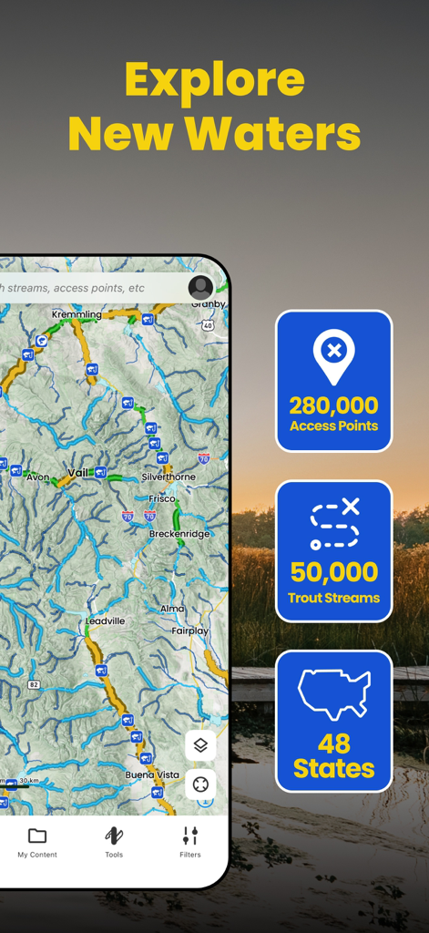
TroutRoutes app interface showing trout streams and access points map.
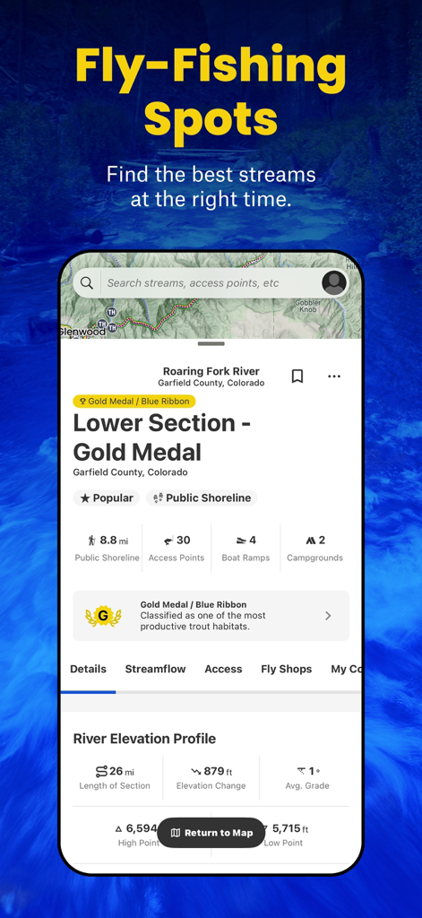
TroutRoutes app interface showing fishing spots and detailed data for the Roaring Fork River in Colorado
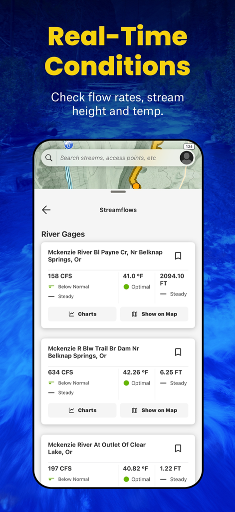
TroutRoutes app interface showing real-time river conditions including flow rates water temperature and stream height
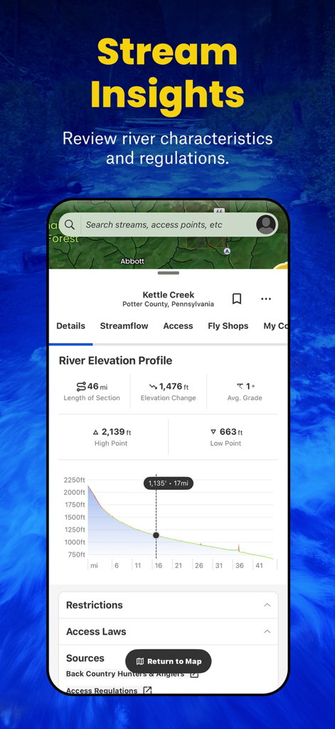
TroutRoutes app display showing river elevation profile and stream characteristics for fly fishing planning.
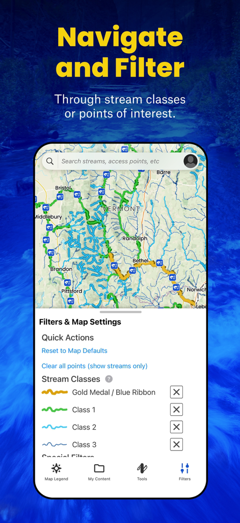
TroutRoutes app interface displaying stream class filters and a topographic map of Vermont trout streams
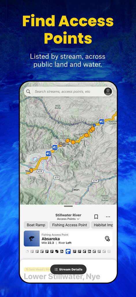
TroutRoutes app screenshot showing a map with fishing access points and stream data for the Stillwater River
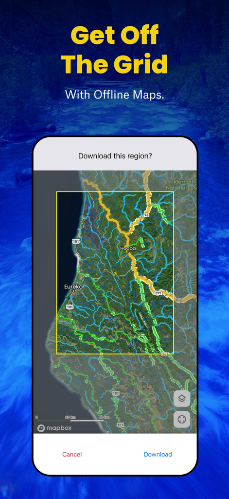
Smartphone screen showing the TroutRoutes app interface for downloading offline maps of trout streams

TroutRoutes app interface for setting custom map waypoints and fishing spots
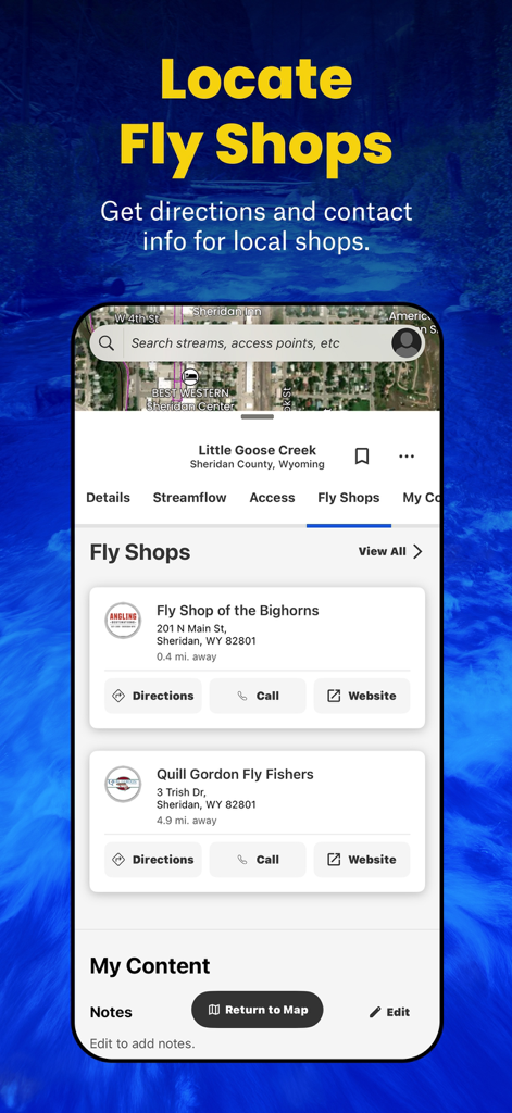
TroutRoutes app interface displaying local fly shops with contact information and directions
Description
Download
More Like This
Apps with similar features and user experience

FishAngler - Fish Finder App
FishAngler, LLC

钓鱼天气预报
Hefei Sasha Technology Co., Ltd.

潮汐表-潮汐天气预报&钓鱼潮汐天气工具助手
荣虎 太

Fishbrain - Fishing App
FishBrain AB

Fishing Points: Map & Forecast
Fishing Points d.o.o.

onX Fish: Midwest Lake Finder
onXmaps, Inc.

Fishbox - Smart Fishing App
MEMS Group, Inc.

釣果記録FishRanker-フィッシュランカー,釣り,分析
SIIG Inc.

Fish Deeper - Fishing App
Deeper UAB
This page is not an official page of the app or its developer, but an independent editorial publication created for informational and commentary purposes. Unless expressly stated otherwise, neither the app nor its developer is affiliated with, endorsed by, sponsored by, authorized by, or otherwise officially connected with MWM, Apple, Google Play, the app publisher, or the app's developer, and nothing on this page implies that the app was developed using MWM's services. Any trademarks, logos, screenshots, and other content remain the property of their respective owners.