This page is not an official page of the app or its developer, but an independent editorial publication created for informational and commentary purposes. Unless expressly stated otherwise, neither the app nor its developer is affiliated with, endorsed by, sponsored by, authorized by, or otherwise officially connected with MWM, Apple, Google Play, the app publisher, or the app's developer, and nothing on this page implies that the app was developed using MWM's services. Any trademarks, logos, screenshots, and other content remain the property of their respective owners.

VesselFinder
Global maritime traffic is no longer a mystery. It reveals the world's shipping lanes and vessel movements in real-time.
Downloads
1M+User Rating
Total Ratings
585Publisher
Category
NavigationLocales
1Latest Version
6.2.1Size
44.3 MBFirst Released
Sep 23, 2014An Analytical Overview of VesselFinder's Core Functionality for Maritime Operations and Enthusiast Engagement
VesselFinder: Key Feature Analysis
Real-time Global AIS Tracking
The app provides immediate, worldwide insights into marine traffic via global AIS data, crucial for real-time monitoring by professionals and enthusiasts.
Comprehensive Port Activity
It allows users to access detailed lists of expected vessels, arrivals, departures, and ships currently within specific ports, vital for port logistics and operational planning.
Predicted Routes & ETAs
This tool features predicted routes and estimated times of arrival (ETAs) to the next port for tracked vessels, significantly aiding logistical planning and scheduling.
Weather Data Overlays
The app offers weather overlays including wind, waves, and temperature, crucial for maritime professionals in planning safe and efficient routes.
Detailed Vessel Specifications
It provides comprehensive vessel particulars, covering technical specifications and cargo capacity information, essential for professional analysis and enthusiast exploration.
Historical Vessel Movement
This tool features vessel movement history with track visualization, enabling review of past routes for operational analysis or tracking a vessel's journey.
Individual Vessel Port Calls
The app displays port calls for each vessel, including arrival times and duration of stay, offering critical data for supply chain management and vessel tracking.
Corporate Contact Information
It includes contact details for the owning company, manager, and ISM manager, facilitating direct professional communication and due diligence.
Personalized Fleet Monitoring
The app allows users to save and monitor favorite vessels, with synchronization across their VesselFinder account for efficient personalized tracking.
Customizable Map Views
This tool offers multiple map styles such as Simple, Detailed, Dark, Satellite, and Nautical, enhancing user experience and visual analysis based on specific needs.
Frequently Asked Questions
Everything you need to know about VesselFinder
What is VesselFinder Lite?
VesselFinder Lite is a marine traffic app providing real-time information on ship positions and movements worldwide. It uses a network of satellites, roaming, and terrestrial AIS receivers.
Does VesselFinder Lite provide real-time vessel tracking?
Yes, VesselFinder Lite provides real-time tracking for over 300,000 vessels daily using global AIS data. The app offers up-to-date insight into global maritime activity.
How does VesselFinder Lite ensure global AIS data coverage?
VesselFinder Lite utilizes a powerful network of satellites, roaming, and terrestrial AIS receivers to deliver global AIS data. Vessel visibility within the app depends on AIS signal availability.
Can I view a vessel's movement history in VesselFinder Lite?
Yes, VesselFinder Lite includes vessel movement history with track visualization. If a vessel is outside terrestrial AIS coverage, its last reported position is displayed and updated when new data is received.
Does VesselFinder Lite show predicted routes and ETAs?
Yes, VesselFinder Lite provides predicted routes and Estimated Times of Arrival (ETAs) to the next port. This feature helps users monitor and plan for vessel movements efficiently.
What kind of vessel particulars does VesselFinder Lite offer?
VesselFinder Lite provides comprehensive vessel particulars, including technical specifications, cargo capacity, and contact details for the owning company, manager, and ISM manager.
How does VesselFinder Lite display port call information?
VesselFinder Lite displays Port Calls per vessel with arrival times and duration of stay. It also provides detailed lists for ports, including expected vessels, arrivals, departures, and ships currently in port.
Can I save my favorite vessels in VesselFinder Lite?
Yes, VesselFinder Lite allows users to save and monitor favorite vessels using the "My Fleet" feature. This data synchronizes with your VesselFinder account for convenience.
What map styles are available in VesselFinder Lite?
VesselFinder Lite offers multiple map styles: Simple, Detailed, Dark, Satellite, and Nautical. Users can also save preferred map views with the "My Views" feature for quick access.
Is extended real-time coverage available in VesselFinder Lite?
Yes, extended real-time coverage via satellite and roaming AIS sources is available through a subscription within VesselFinder Lite. This provides data beyond terrestrial AIS areas.
Does VesselFinder Lite include weather information?
Yes, VesselFinder Lite integrates weather overlays including wind, waves, and temperature. This enhances the maritime tracking experience with relevant environmental data.
Can I measure distances on the map in VesselFinder Lite?
Yes, VesselFinder Lite provides a distance measurement tool. This feature enables users to accurately estimate routes and ranges directly on the app's map interface.
Is the information provided by VesselFinder Lite guaranteed to be accurate?
No, while VesselFinder Lite strives for accuracy, the completeness of its information cannot be guaranteed. This is due to reliance on AIS signal availability and data reception.
The following screenshots and description are sourced directly from the app's official store listing and are the property of the app developer.
App Store
Screenshots

Observe how the app displays live vessel positions with colored icons and provides immediate information like destination and ETA for specific ships.
Real-Time Tracking
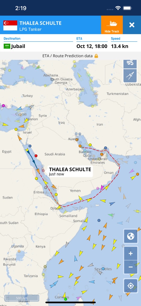
This view illustrates how the app visualizes a vessel's predicted route with a clear dotted line and provides detailed ETA/Route Prediction data for future movements.
Route Prediction

Explore busy port areas like Shenzhen, where the app differentiates various vessel types such as 'Small Craft' and 'Liquid' carriers, indicating detailed maritime traffic.
Port Activity Map
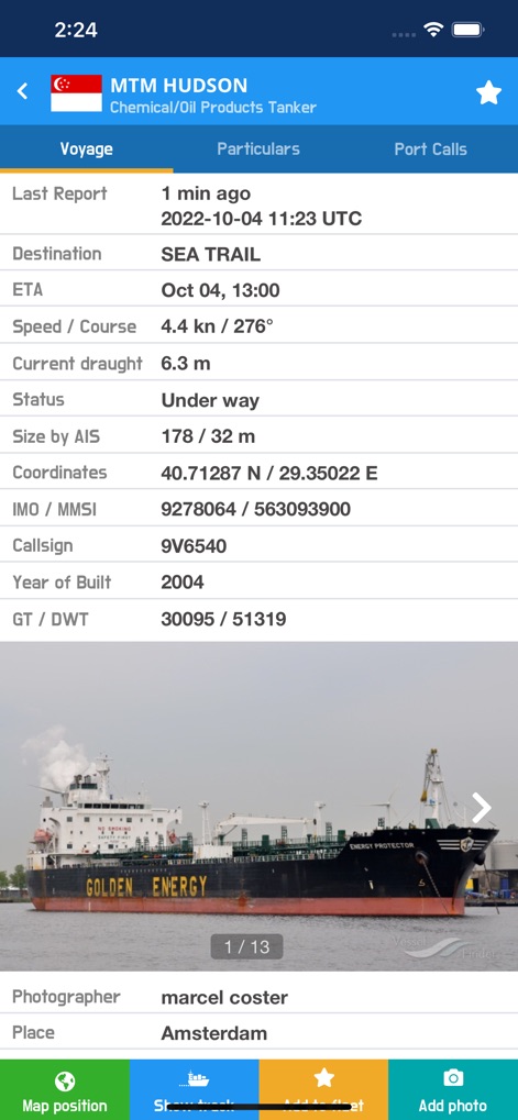
Access extensive voyage particulars for any vessel, including its last reported position and current status, complemented by a browsable photo gallery displaying multiple images.
Vessel Voyage Details

Users can review comprehensive vessel particulars such as gross tonnage and length overall, alongside critical ownership and classification society information.
Detailed Specifications
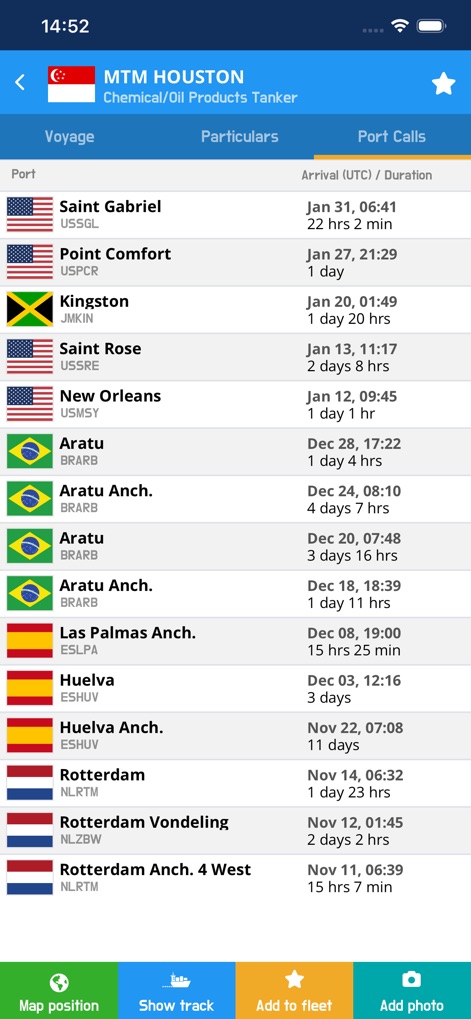
This section provides a complete history of a vessel's port calls, detailing arrival times and the duration of its stay at various global ports.
Port Call History

The robust search feature allows users to quickly find specific vessels or ports, displaying results with clear vessel types and estimated times of arrival.
Global Search Power

Get a detailed overview of port activities, including a list of expected vessels with their ETAs and specific types, providing valuable operational insights.
Port Schedule Overview

Utilize the app's advanced route planning features to plot journeys, displaying precise distance measurements between waypoints and estimated bearings.
Route Planning Tools

Organize and monitor favorite vessels efficiently within 'My Fleet', where ships are categorized by type such as 'Cruise ships' and 'Container ships' for quick access.
Personalized Fleet Management
Description
Download
More Like This
Apps with similar features and user experience

Ship Info
Oleksiy Koldunov

Ship Tracker
Rocketech sp. z o.o.

Boat Watch - Ship Tracking
Pocket Mariner Ltd.

MarineRadar・Vessel Finder
Lascade LLC

Marine Traffic :Ship Tracker
Kathy Spencer

MyShipTracking
Nativity

Boat Beacon
Pocket Mariner Ltd.

Boat Watch Pro
Pocket Mariner Ltd.

Ship Finder
pinkfroot limited
This page is not an official page of the app or its developer, but an independent editorial publication created for informational and commentary purposes. Unless expressly stated otherwise, neither the app nor its developer is affiliated with, endorsed by, sponsored by, authorized by, or otherwise officially connected with MWM, Apple, Google Play, the app publisher, or the app's developer, and nothing on this page implies that the app was developed using MWM's services. Any trademarks, logos, screenshots, and other content remain the property of their respective owners.