This page is not an official page of the app or its developer, but an independent editorial publication created for informational and commentary purposes. Unless expressly stated otherwise, neither the app nor its developer is affiliated with, endorsed by, sponsored by, authorized by, or otherwise officially connected with MWM, Apple, Google Play, the app publisher, or the app's developer, and nothing on this page implies that the app was developed using MWM's services. Any trademarks, logos, screenshots, and other content remain the property of their respective owners.

Vikazimut
Ditch the paper maps and compass. Whether you’re a competitive trail runner or a family explorer, use GPS-powered navigation to find checkpoints, track your route, and analyze your performance.
Downloads
27K+User Rating
Total Ratings
0Publisher
Category
SportsLocales
1Latest Version
3.17.0Size
27.1 MBFirst Released
Jun 16, 2021Master Every Trail with Precision
The all-in-one digital toolkit that turns every hike or run into a high-tech navigation challenge, replacing bulky gear with smart performance tracking.
All-in-One Digital Toolkit
Leave the paper maps and physical compasses at home. Replace traditional gear with an eco-friendly, GPS-enabled interface designed for the modern navigator.
Post-Adventure Analysis
Dive into your data with retrospective route traces and split times. Perfect for athletes who want to analyze their path choice and optimize their performance.
Frequently Asked Questions
Everything you need to know about Vikazimut
What is Vikazimut?
Vikazimut is an application that facilitates orienteering sports. It replaces physical maps, compasses, and control cards, providing a digital platform for navigation and route analysis.
How does Vikazimut help with orienteering?
Vikazimut helps orienteers find their way using a digital map. It validates checkpoints via QR codes or GPS and provides retrospective analysis with total time, split times, and course trace.
Does Vikazimut offer different activity modes?
Yes, Vikazimut offers three modes: Sport, Geocaching, and Walk. Sport mode has no GPS assistance but includes a timer and statistics. Walk mode provides real-time GPS assistance.
Can users get real-time GPS assistance in Vikazimut?
Yes, Vikazimut's Walk mode provides real-time GPS assistance, positioning the orienteer on the map. Race mode (Sport mode) does not offer this assistance.
How does Vikazimut record progress during a course?
Vikazimut records progress by allowing users to validate checkpoints manually with QR codes or automatically using GPS position, replacing traditional control cards.
What statistics does Vikazimut provide after a course?
After a course, Vikazimut displays total time, split times, and the course trace on the map. It also shows distance covered and route pace.
Does Vikazimut replace physical orienteering tools?
Yes, Vikazimut replaces the traditional map, compass, and control card, integrating these functions into the application for a streamlined orienteering experience.
Can Vikazimut display cultural information?
Yes, in the Walk mode, some routes in Vikazimut display cultural information at checkpoints, offering an enriched experience for the orienteer.
How are courses managed in Vikazimut?
Vikazimut allows users to flash a course using a QR code or select from a list of available courses. Courses display creation source, length, and distance to site.
Does Vikazimut offer different modes for GPS usage?
Yes, Vikazimut's Sport and Geocaching modes operate without GPS assistance. The Walk mode provides real-time GPS assistance.
The following screenshots and description are sourced directly from the app's official store listing and are the property of the app developer.
App Store
Screenshots
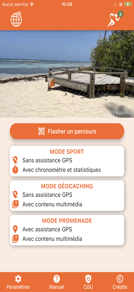
Vikazimut app home screen showing sport geocaching and walk modes for orienteering navigation
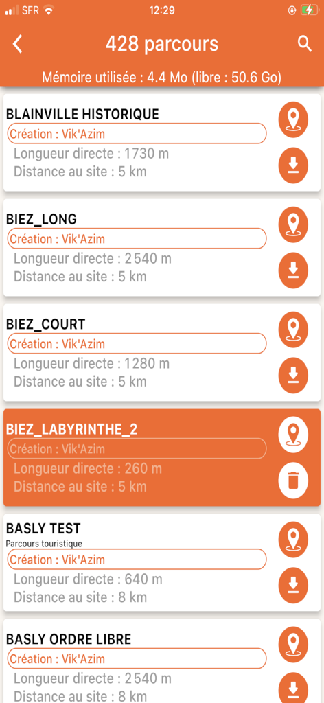
Vikazimut mobile app interface showing a list of orienteering courses with distance and length details
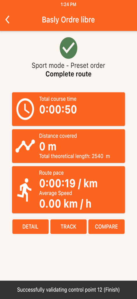
Vikazimut app summary screen showing course time, distance, and pace statistics for a completed orienteering route in sport mode
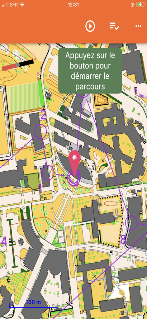
Orienteering map in Vikazimut app showing numbered checkpoints and a route.
Description
Download
More Like This
Top-ranked apps in the same category

得物 - 得到美好事物
Shanghai Dewu Information Group Co., Ltd.

懂球帝 - 足球篮球体坛数据
Hainan Football-Loving Girl Network Technology Co., Ltd.

虎扑-评分篮球足球游戏影视
Shanghai Kuanghui Network Technology Co., LTD

Underdog Sports
Underdog Sports, Inc.

Olympic Games™
International Olympic Committee

ESPN: Live Sports & Scores
Disney Electronic Content, Inc.

Flashscore: Live Scores & News
Livesport s.r.o.

DraftKings Sportsbook & Casino
DRAFTKINGS LLC.

PrizePicks - Sports Picks
SidePrize, LLC
This page is not an official page of the app or its developer, but an independent editorial publication created for informational and commentary purposes. Unless expressly stated otherwise, neither the app nor its developer is affiliated with, endorsed by, sponsored by, authorized by, or otherwise officially connected with MWM, Apple, Google Play, the app publisher, or the app's developer, and nothing on this page implies that the app was developed using MWM's services. Any trademarks, logos, screenshots, and other content remain the property of their respective owners.