This page is not an official page of the app or its developer, but an independent editorial publication created for informational and commentary purposes. Unless expressly stated otherwise, neither the app nor its developer is affiliated with, endorsed by, sponsored by, authorized by, or otherwise officially connected with MWM, Apple, Google Play, the app publisher, or the app's developer, and nothing on this page implies that the app was developed using MWM's services. Any trademarks, logos, screenshots, and other content remain the property of their respective owners.

WillyWeather
Weather's unpredictable; your plans don't have to be. The app empowers users to command their outdoor world, armed with pinpoint forecasts.
Downloads
1M+User Rating
Total Ratings
389.6KPublisher
Category
WeatherLocales
1Latest Version
3.2.0Size
126.3 MBFirst Released
Dec 21, 2013In-depth Weather Intelligence for Outdoor & Marine Enthusiasts
WillyWeather: Core Capabilities Analysis
Advanced Tidal Data & Predictions
The app offers the most extensive tide times system in the USA, integrating NOAA data with specific location offsets for accurate marine planning and safety.
Precision Wind Forecasting
This tool provides highly accurate global wind forecasts, meticulously interpolated to exact coordinates and vetted against real-time observations, crucial for marine and air-sensitive activities.
Detailed Swell Information
It delivers precise swell height, period, and direction data for every beach and surf spot in the USA, essential for surfers and beach activity planners.
Highly Localized & Granular Forecasts
The app provides hyper-local weather data, fine-tuned to specific coordinates for thousands of specific locations including beaches, rivers, and parks, ensuring unparalleled precision for outdoor ventures.
Targeted NOAA Weather Warnings
It ensures users receive easily accessible and specifically targeted NOAA warnings for affected locations, which is critical for personal safety and activity planning.
Interactive Radar & Cloud Cover
This tool features interactive NOAA radar and national satellite views, allowing users to pan and zoom for real-time rainfall and cloud cover tracking, vital for immediate decision-making.
Frequently Asked Questions
Everything you need to know about WillyWeather
What is WillyWeather?
WillyWeather is a local weather service app that organizes global weather data into valuable local information. It provides radar, satellite, wind, rain, tide, swell, and UV forecasts, along with moon phases and sunrise/sunset times.
Does WillyWeather provide weather forecasts?
Yes, WillyWeather provides six-day NOAA weather forecasts. These forecasts are tailored to specific locations and include minimum/maximum temperatures and detailed weather descriptions.
Can I view rainfall radar on WillyWeather?
Yes, WillyWeather features interactive rainfall radar using raw NOAA data integrated with iOS maps. Users can pan and zoom through the national NOAA radar network to see rain falling.
Does WillyWeather offer real-time weather observations?
Yes, WillyWeather provides real-time observational data for all locations. This includes current temperature, feels-like temperature, rain today, rain last hour, humidity, pressure, wind speed, and dew point.
Can WillyWeather provide tide information?
Yes, WillyWeather offers a comprehensive tide times system for the USA. It combines NOAA standard port data with specific location offsets, covering US beaches, river systems, and inlets.
Does WillyWeather support weather alerts?
Yes, WillyWeather supports various weather alerts. Users can create custom rain alerts, receive notifications for specific weather conditions like swell and wind, and get NOAA warnings.
Can I set custom rain alerts in WillyWeather?
Yes, WillyWeather allows users to create custom rain alerts. These alerts can be tailored for specific locations, such as 'Rain at mom and dad's' or 'Rain at the farm,' as shown in the app.
Does WillyWeather show wind forecasts?
Yes, WillyWeather provides accurate global wind forecast models gathered from NOAA. It interpolates data to exact coordinates and validates it against real-time observations for optimal performance.
Does WillyWeather offer Apple Watch support?
Yes, WillyWeather provides accurate information on your wrist through Apple Watch integration. The watch interface displays current weather, forecasts, and radar.
Are there widgets available for WillyWeather?
Yes, WillyWeather offers widgets to display various weather information. These include current temperature, swell conditions, radar maps, wind speed, high tide times, and extended forecasts.
The following screenshots and description are sourced directly from the app's official store listing and are the property of the app developer.
App Store
Screenshots

Users can explore six-day NOAA weather forecasts with min/max temperatures and detailed descriptions, alongside an interactive graph visualizing wind speed and gusts.
Forecast Precision Unveiled

This app provides instant notification pop-ups for impending rain events and offers an intuitive interface for users to create and manage custom rain alerts for specific locations.
Timely Rain Alerts
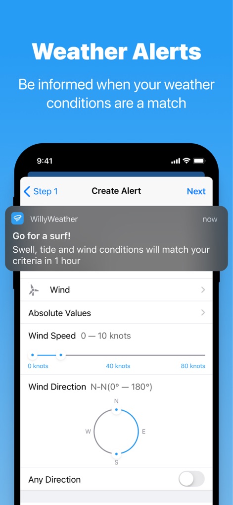
The app allows users to define custom weather alerts using specific criteria like wind speed and direction, generating notifications when conditions match for activities such as surfing.
Personalized Weather Criteria

This tool delivers government-issued flood warning notifications directly to users, featuring a map overlay to pinpoint the affected areas and detailed warning information including location and issuance specifics.
Critical Warning Insights

Users can explore an interactive radar map displaying current and forecast rain intensity, complemented by a timeline slider that projects future rainfall over time.
Dynamic Radar Visualization
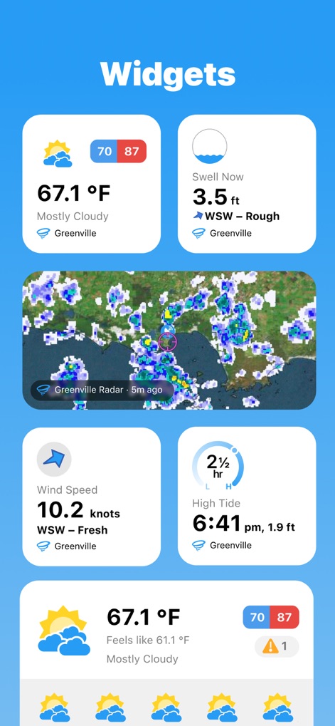
The app offers a suite of customizable home screen widgets, allowing quick access to essential information such as general weather forecasts, swell conditions, and interactive radar views directly from the device's home screen.
At-a-Glance Data
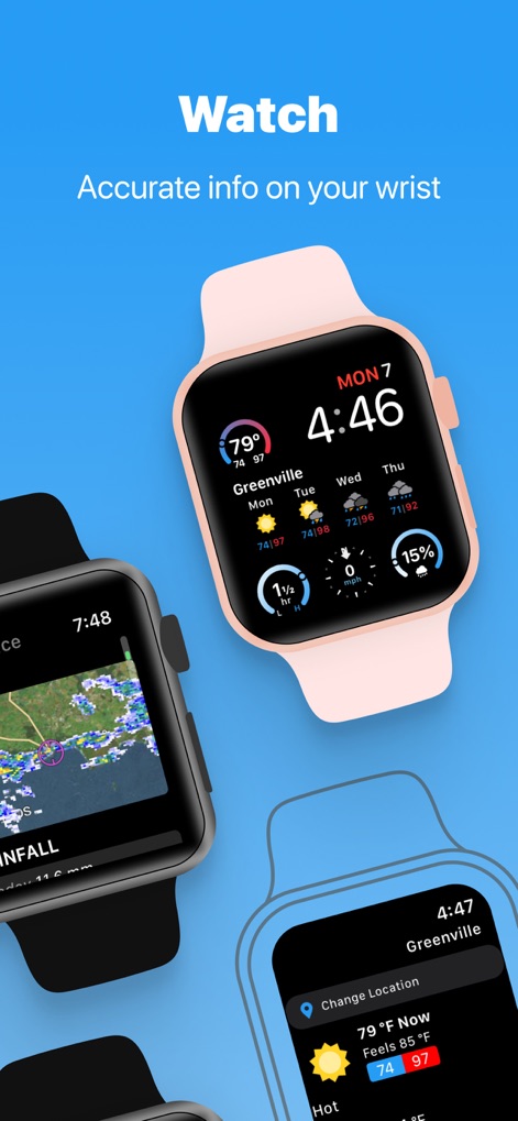
Users can access crucial weather information directly on their Apple Watch, featuring glanceable daily forecasts with temperature details and a dedicated watch app displaying current location weather.
Wearable Weather Insights
Description
Download
More Like This
Apps with similar features and user experience

墨迹天气-MojiWeather
Beijing MojiFengyun Technology Co.,Ltd.

Windy.com
Windyty, SE

天气通
Weibo Internet Technology (China) Co.Ltd.

Zoom Earth - Weather Forecast
Neave Interactive Limited

实时天气-40日精准天气实时预报
犇 牛

MyRadar Accurate Weather Radar
Aviation Data Systems, Inc

Ventusky: Weather & Live Radar
Ventusky s.r.o.

FOX Weather: Daily Forecasts
Fox News Network, LLC

2345天气王-天气和空气质量查询小组件
Shanghai 2345 Network Technology Co., Ltd.
This page is not an official page of the app or its developer, but an independent editorial publication created for informational and commentary purposes. Unless expressly stated otherwise, neither the app nor its developer is affiliated with, endorsed by, sponsored by, authorized by, or otherwise officially connected with MWM, Apple, Google Play, the app publisher, or the app's developer, and nothing on this page implies that the app was developed using MWM's services. Any trademarks, logos, screenshots, and other content remain the property of their respective owners.