このページはアプリまたはその開発者の公式ページではなく、情報提供および論評を目的として作成された独立した編集出版物です。明示的に別段の記載がない限り、アプリおよびその開発者は、MWM、Apple、Google Play、アプリのパブリッシャー、またはアプリの開発者と提携、承認、後援、認可、またはその他の公式的な関係はなく、このページのいかなる内容も、アプリがMWMのサービスを使用して開発されたことを意味するものではありません。すべての商標、ロゴ、スクリーンショット、その他のコンテンツはそれぞれの所有者の財産です。

Acres: Land Data & Parcel Maps
土地所有者の名前、正確な物件境界線、包括的な土壌レポートに即座にアクセスできます。デスクトップからフィールドまで、専門家向けに設計された3Dマップ、過去のデータ、オフライン追跡を使用して土地の可能性を評価します。
ダウンロード
469K+ユーザー評価
評価数
1K+開発元
カテゴリ
Business対応言語
1最新バージョン
3.5.4サイズ
133.7 MBリリース日
2022年10月4日本格的な土地管理のための精密ツール
物件境界線の確認から土壌品質の評価まで、Acresは外出先での情報に基づいた意思決定に必要な包括的なデータを提供します。
即時土地所有者データ
数百万の米国区画にわたる所有者と正確な境界線を即座に特定し、郡書記官事務所での時間を節約します。
詳細な区画インテリジェンス
土壌組成、過去の作物収量、洪水ゾーン、地形図に関するプロフェッショナルグレードの洞察によりリスクを軽減します。
よくある質問
について知っておくべきこと Acres: Land Data & Parcel Maps
Acresアプリは何に使用されますか?
Acresアプリは、不動産の境界線、土地所有者の情報、販売用土地を発見するためのマッピングおよび土地分析ツールです。区画レベルの洞察を提供し、不動産マップの保存と共有を可能にします。
Acresアプリで販売用土地を検索できますか?
はい、Acresアプリを使用すると、米国全土で販売されている土地を即座に見つけて共有できます。この機能はアプリケーション内で直接アクセスできます。
Acresは不動産の境界線の特定にどのように役立ちますか?
Acresアプリを使用すると、ユーザーは正確な不動産の境界線を確認できます。また、不動産の境界線の特定や、土地分析のための区画レベルの洞察の評価を容易にします。
Acresアプリは土地所有者の詳細情報を提供しますか?
はい、Acresアプリは土地所有者の情報を提供し、特定の区画の名前を表示します。この機能は、ユーザーの包括的な土地分析を支援します。
Acresマップはオフラインで使用できますか?
はい、Acresはオフラインマップをサポートしています。ユーザーは、インターネット接続なしで継続的なマッピング機能を確認できるように、オフグリッド時に保存された衛星表示エリアまたはカスタムマップにアクセスできます。
Acresには3Dマップ表示機能が含まれていますか?
はい、Acresには3Dマップ表示機能が含まれています。ユーザーは3Dモードで地形を視覚化し、この機能をオンまたはオフに切り替えて、さまざまな角度から土地を探索できます。
Acresアプリはルート追跡機能がありますか?
はい、Acresアプリにはルート追跡機能があります。ユーザーは自分の経路を追跡して保存し、物件上を歩きながら距離と標高の変化を測定できます。
Acresでカスタムマップを作成するにはどうすればよいですか?
Acresでは、写真にジオタグを付けたり、メモを追加したり、関心のある地点をマークしたりすることで、カスタムマップを作成できます。これらのパーソナライズされたマップは、モバイルとデスクトップ間で自動的に同期されます。
Acresで利用可能な土地データレイヤーは何ですか?
Acresは、土壌マップ、標高、過去の画像、植生指数、作付履歴、郡の賃料、郡の収量、固定資産税、洪水/湿地情報など、多数の土地データレイヤーを提供しています。
Acresからマップや土地データを共有できますか?
はい、Acresではアプリから直接不動産マップや土地データを共有できます。ユーザーはマップから特定のウェイポイントを共有することもできます。
Acresはモバイルデバイスとデスクトップデバイス間で同期しますか?
はい、Acresはモバイルデバイスとデスクトップ間で不動産マップとカスタムマップのシームレスな同期を提供します。これにより、さまざまなプラットフォームで継続的な分析が可能になります。
Acresアプリのサブスクリプションはどのように請求されますか?
Acresアプリのサブスクリプションは、iTunesアカウントを通じてクレジットカードに請求されます。現在の期間が終了する少なくとも24時間前にキャンセルされない限り、自動的に更新されます。
Acresはサブスクリプションまたは無料トライアルの払い戻しを提供していますか?
いいえ、Acresは期間中にキャンセルされたサブスクリプション料金の払い戻しを提供していません。無料トライアルの未使用部分は、サブスクリプションが有効になると失効します。
Acresの利用規約とプライバシーポリシーはどこで確認できますか?
Acresの利用規約とプライバシーポリシーは、ウェブサイトで確認できます。ユーザーは、www.acres.com/terms-of-useおよびwww.acres.com/privacy-policyの提供されたリンクからこれらのドキュメントにアクセスできます。
Acresアプリには広告が含まれていますか?
いいえ、Acresアプリには広告は含まれていません。ユーザーは、すべての機能を使用しながら広告なしのインターフェースを体験できます。
以下のスクリーンショットと説明は、アプリの公式ストアリスティングから直接取得されたものであり、アプリ開発者の所有物です。
アプリストア
スクリーンショット
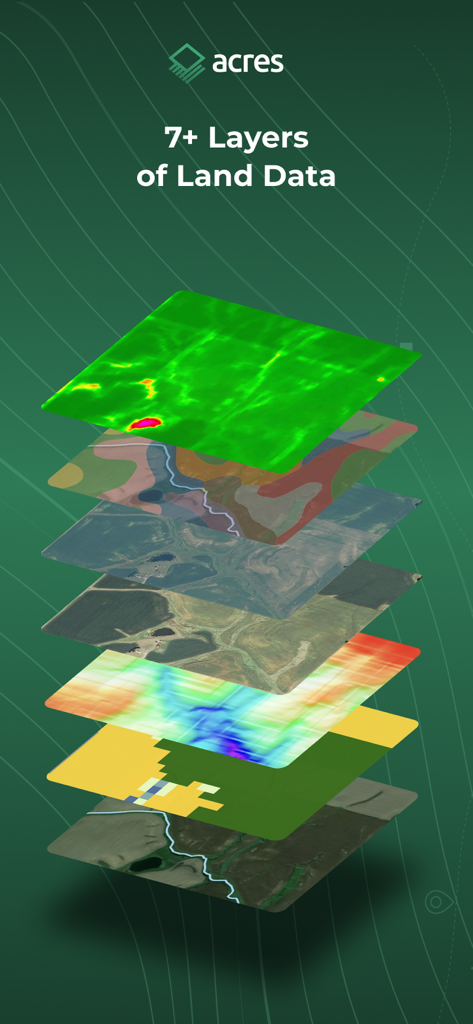
Acresアプリからの衛星ビュー、地形、土壌情報を示す7つの異なるマップデータレイヤーのスタック
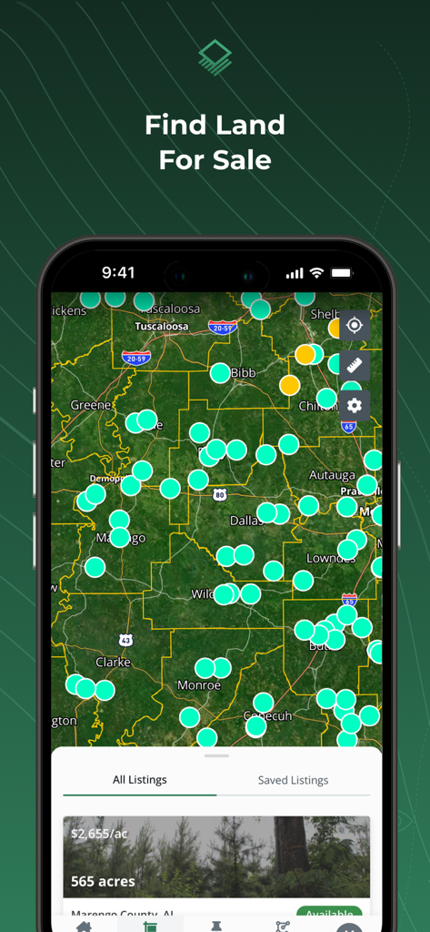
Acresアプリのマップビュー。販売用土地リストと物件ピンを表示
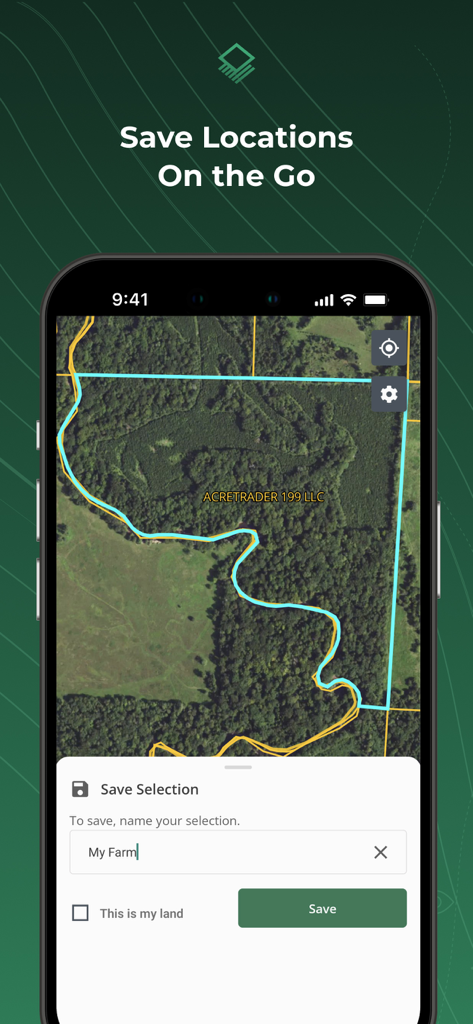
Acresアプリのインターフェイス。衛星マップにハイライトされた土地区画と保存プロンプトを表示
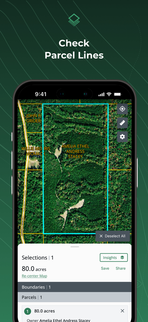
Acresアプリのインターフェイス。衛星マップに土地区画の境界線と土地所有者情報を表示
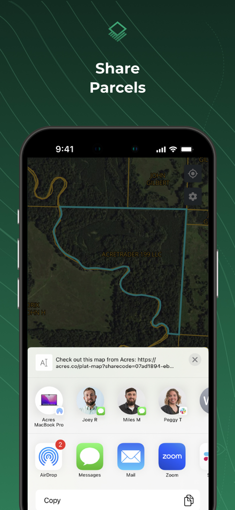
土地マップと共有オプションを備えたAcresアプリの共有区画機能を示すiPhone画面
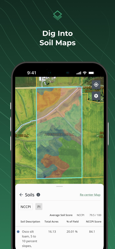
特定の土地区画の詳細な土壌組成データとカラフルな土壌マップオーバーレイを表示するAcresアプリを備えた携帯電話画面
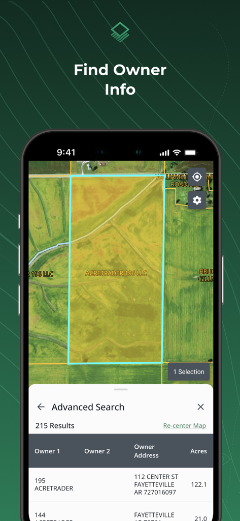
衛星マップに土地所有者の名前と物件区画の詳細を表示するAcresアプリのインターフェイス
説明
Download
類似アプリ
似た機能とユーザー体験を持つアプリ

LandGlide: Find Property Lines
Real Estate Portal USA, LLC

Regrid Property App
Loveland Technologies, LLC

DealCheck: Analyze Real Estate
Fortnoff Financial LLC

Reventure App
Reventure App LLC

Land id®
MapRight, LLC

Tapusor
TUVIMER ARGE FAALIYETLERI VE TEKNOLOJI SISTEMLERITICARET ANONIM SIRKETI

Endeksa: Value & Sell Property
Endeksa Teknoloji Anonim Sirketi

Detector Maps
GOLD DISCOVERY SOLUTIONS PTY LTD

Parceled Land Map
Uri Nemirovsky
このページはアプリまたはその開発者の公式ページではなく、情報提供および論評を目的として作成された独立した編集出版物です。明示的に別段の記載がない限り、アプリおよびその開発者は、MWM、Apple、Google Play、アプリのパブリッシャー、またはアプリの開発者と提携、承認、後援、認可、またはその他の公式的な関係はなく、このページのいかなる内容も、アプリがMWMのサービスを使用して開発されたことを意味するものではありません。すべての商標、ロゴ、スクリーンショット、その他のコンテンツはそれぞれの所有者の財産です。