このページはアプリまたはその開発者の公式ページではなく、情報提供および論評を目的として作成された独立した編集出版物です。明示的に別段の記載がない限り、アプリおよびその開発者は、MWM、Apple、Google Play、アプリのパブリッシャー、またはアプリの開発者と提携、承認、後援、認可、またはその他の公式的な関係はなく、このページのいかなる内容も、アプリがMWMのサービスを使用して開発されたことを意味するものではありません。すべての商標、ロゴ、スクリーンショット、その他のコンテンツはそれぞれの所有者の財産です。

Land id®
不動産プロフェッショナルや投資家が、1億5500万件の区画、地形、所有者詳細にワンタップでアクセスできる業界をリードするツール。現場でのオフライン利用も可能。
ダウンロード
510K+ユーザー評価
評価数
3K+開発元
カテゴリ
Productivity対応言語
1最新バージョン
5.29.0サイズ
270.0 MBリリース日
2016年11月9日土地プロフェッショナルのための精密マッピング
所有権データ、3D地形、現場向けに設計されたプロ仕様のマッピングツールに即座にアクセスし、デューデリジェンスを加速。
包括的な区画インテリジェンス
1億5500万件以上の区画について、所有者詳細、税評価額、販売履歴に即座にアクセスし、機会を特定してリスクを軽減。
高度な3Dおよび地形分析
等高線と没入型の3Dビューで地形を視覚化し、土壌タイプ、建設可能地、洪水位をどこからでも評価。
よくある質問
について知っておくべきこと Land id®
Land idには無料トライアル期間がありますか?
はい、Land idは7日間の無料トライアルを提供しています。このトライアルでは、全期間においてLand idの全プランにフルアクセスできます。
Land idアプリはどのようなコア機能を提供していますか?
Land idは、広範な物件データカード、3D物件の可視化、物件の簡単な特定とマッピングを提供します。等高線、光ファイバー密度、地下水情報などの機能が含まれています。
Land idは物件の境界線と土地所有権情報を表示できますか?
はい、Land idは物件の線、区画の境界線、土地所有権の詳細を瞬時に表示します。全国1億5500万件以上の区画記録にアクセスできます。
Land idのサブスクリプションの月額料金はいくらですか?
Land idの標準プランの月額料金は、月払いの場合は15ドル、年払いの場合は月額7ドル(年間84ドル)です。
Land idは3D物件表示と等高線をサポートしていますか?
はい、Land idでは物件を2Dまたは3Dで表示でき、場所を生き生きとさせます。また、地図上で等高線を使用して地形の起伏を表示します。
Land idはフィールドワークのためのオフラインアクセスを提供していますか?
Land idは、現場での使用と衛星GPS追跡のためのオフラインアクセスを提供します。これにより、ユーザーはインターネット接続なしで物件データにアクセスできます。
Land idは水域と洪水リスクデータを示していますか?
はい、Land idは湿地、井戸、FEMAの洪水区域情報を含む水へのアクセス情報を特定します。これにより、洪水リスクを評価し、土地利用の決定に役立てることができます。
Land id Premiumにはどのような追加機能が含まれていますか?
Land id Premiumには、3つのカスタムマップをWeblinksで作成および共有する機能、マップ作成ツール、高解像度航空写真マップへのアクセスが含まれています。また、モバイルオフラインマップ作成も可能です。
Land id Proの機能は何ですか?
Land id Proでは、ウェブサイトにマップを埋め込んだり、会社情報でマップをブランド化したり、測量図、公図、画像オーバーレイツールを使用したりできます。また、公図ドロワーと高解像度印刷マップも提供しています。
Land id Pro UnlimitedはCSVレポートを生成できますか?
はい、Land id Pro UnlimitedはCSVレポートとメーリングリストを生成できます。この機能は、レコードあたり7セントの料金がかかります。
以下のスクリーンショットと説明は、アプリの公式ストアリスティングから直接取得されたものであり、アプリ開発者の所有物です。
アプリストア
スクリーンショット
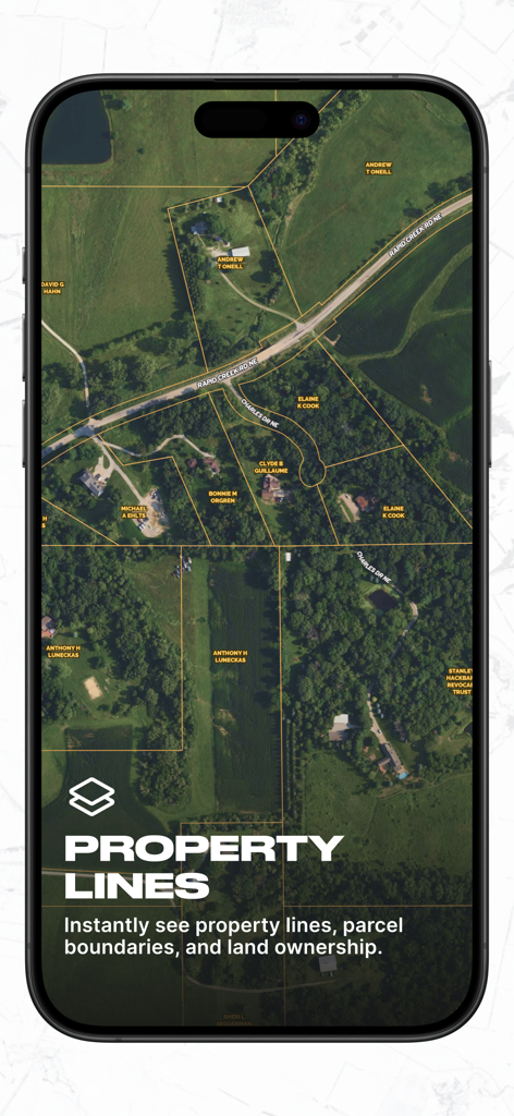
所有者名と敷地境界線が含まれる衛星画像を表示したLand idアプリのスクリーンショット
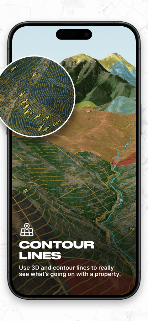
プロ向けの土地分析用に詳細な等高線と標高マークが付いた3D地形図を表示するLand idモバイルアプリのインターフェース
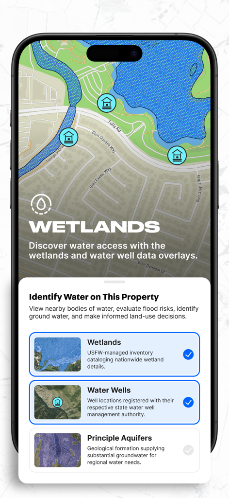
物件マップ上に湿地と井戸のデータをオーバーレイ表示するLand idアプリのインターフェース
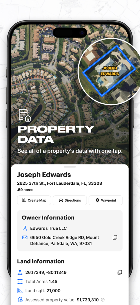
所有者情報と区画面積を示す詳細な物件データカードを表示したLand idアプリのスマートフォン画面
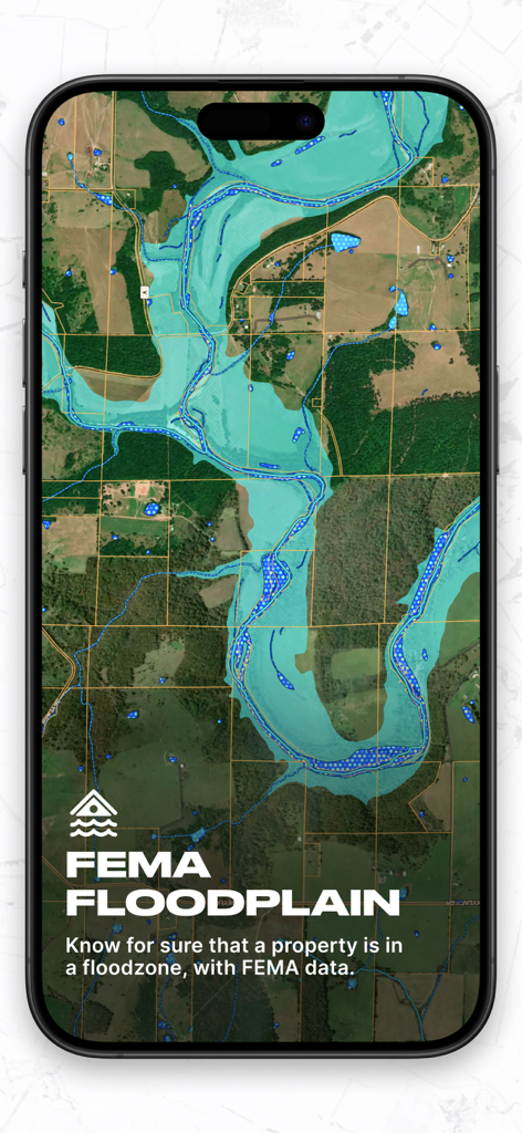
デューデリジェンス用に、衛星物件マップ上にFEMA洪水位データをオーバーレイ表示するLand idアプリのインターフェース
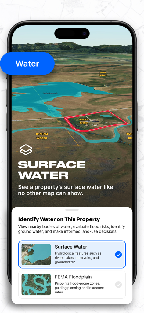
3D物件区画マップ上に地表水とFEMA洪水位マッピングを表示するLand idアプリのインターフェース
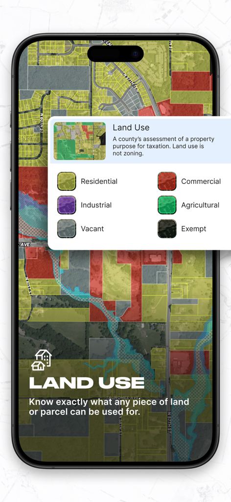
住宅、商業、工業などの土地利用によって色分けされた物件区画マップを表示するLand idアプリのモバイル画面
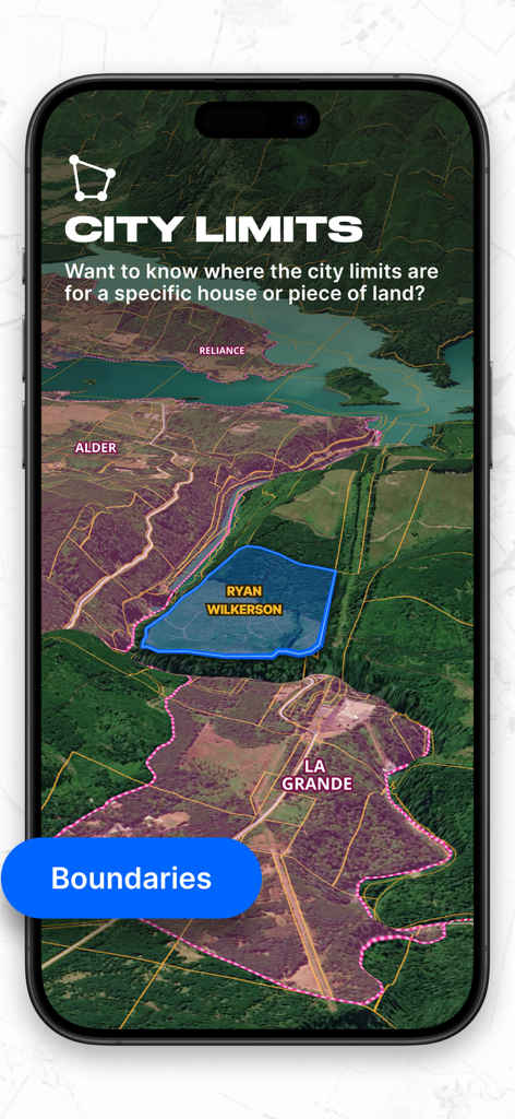
3D地形図上に市境と物件境界を表示するLand idアプリ
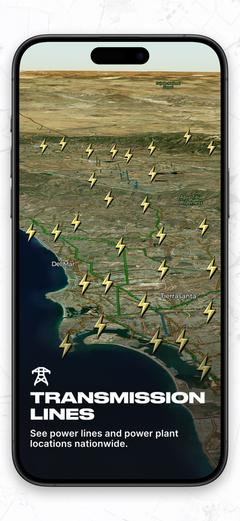
3D地形図上に全国の送電線と発電所の位置を表示するLand idアプリのインターフェース
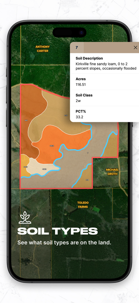
色分けされた土壌タイプを示すマップと、土壌の説明および面積を示す物件データカードを表示するLand idアプリのモバイルインターフェース
説明
Download
類似アプリ
似た機能とユーザー体験を持つアプリ

LandGlide: Find Property Lines
Real Estate Portal USA, LLC

Regrid Property App
Loveland Technologies, LLC

DealCheck: Analyze Real Estate
Fortnoff Financial LLC

Reventure App
Reventure App LLC

Acres: Land Data & Parcel Maps
AcreMaps, LLC

Tapusor
TUVIMER ARGE FAALIYETLERI VE TEKNOLOJI SISTEMLERITICARET ANONIM SIRKETI

Endeksa: Value & Sell Property
Endeksa Teknoloji Anonim Sirketi

Detector Maps
GOLD DISCOVERY SOLUTIONS PTY LTD

Parceled Land Map
Uri Nemirovsky
このページはアプリまたはその開発者の公式ページではなく、情報提供および論評を目的として作成された独立した編集出版物です。明示的に別段の記載がない限り、アプリおよびその開発者は、MWM、Apple、Google Play、アプリのパブリッシャー、またはアプリの開発者と提携、承認、後援、認可、またはその他の公式的な関係はなく、このページのいかなる内容も、アプリがMWMのサービスを使用して開発されたことを意味するものではありません。すべての商標、ロゴ、スクリーンショット、その他のコンテンツはそれぞれの所有者の財産です。