このページはアプリまたはその開発者の公式ページではなく、情報提供および論評を目的として作成された独立した編集出版物です。明示的に別段の記載がない限り、アプリおよびその開発者は、MWM、Apple、Google Play、アプリのパブリッシャー、またはアプリの開発者と提携、承認、後援、認可、またはその他の公式的な関係はなく、このページのいかなる内容も、アプリがMWMのサービスを使用して開発されたことを意味するものではありません。すべての商標、ロゴ、スクリーンショット、その他のコンテンツはそれぞれの所有者の財産です。

Altimeter GPS & Barometer
究極のオフラインサバイバルツールキットでバックカントリーを征服しよう。インターネット接続なしで、高精度の高度測定値、気圧データ、信頼性の高いナビゲーションツールにアクセスできます。
ダウンロード
799K+ユーザー評価
評価数
5K+開発元
カテゴリ
Navigation対応言語
14最新バージョン
7.2サイズ
98.0 MBリリース日
2012年11月8日比類なき精度で、すべてのピークを制覇
バックカントリーのために作られたプロ仕様のナビゲーションツール。完全にオフラインでも完璧に機能します。
ゼロシグナル信頼性
セルラーデータやWi-Fiを必要としない、内部GPSと気圧センサーを使用したリモートの荒野をナビゲートします。
プログレードの高度データ
GPS、Aster、気圧の入力を組み合わせたPure Altitude Algorithmによる、手術レベルの精度を体験してください。
よくある質問
について知っておくべきこと Altimeter GPS & Barometer
Altimeter GPSはインターネット接続が必要ですか?
はい、Altimeter GPSはオフラインでの使用を想定して設計されています。インターネット接続なしで、iPhoneのGPSと気圧計のデータを高度なアルゴリズムで直接読み取ります。これにより、主要な高度と速度計の機能にインターネット接続は不要です。
Altimeter GPSアプリにはどのような機能が含まれていますか?
Altimeter GPSは、正確な高度計、速度計、気圧計、歩数計、日の出/日の入り計算機、位置ファインダー、懐中電灯、コンパス、クロノメーター、複数の地図タイプを提供します。
Altimeter GPSはどのように高度を測定しますか?
Altimeter GPSは、「Pure Altitude Algorithm」を使用して正確な高度を測定します。インターネット接続を必要とせず、iPhoneのセンサーからのGPS、Aster、または気圧計データを利用します。
Altimeter GPSで歩数をカウントできますか?
はい、Altimeter GPSには歩数計/ステップカウンターが含まれています。iPhone 5s/6/6 PlusモデルのM7コプロセッサを利用して、セットアップなしで自動的に歩数をカウントします。
Altimeter GPSはさまざまな種類の地図を提供していますか?
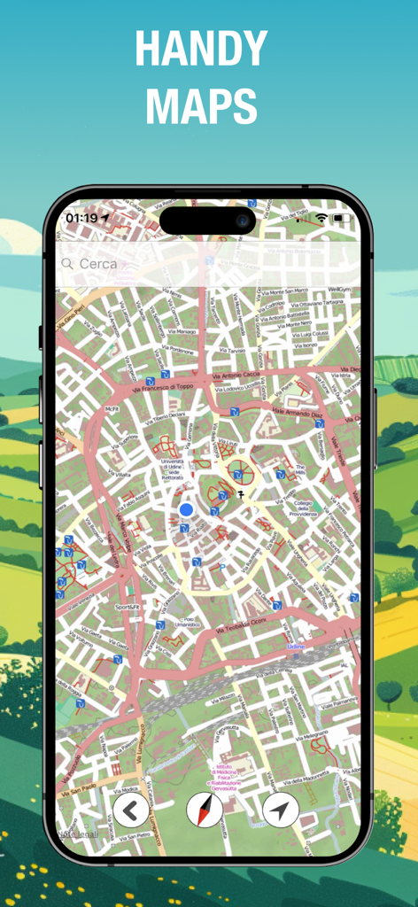
はい、Altimeter GPSは、ナビゲーションのためにOpen Street Map、Hike Map、Stamen Map、Open Cycle Mapなど、複数の地図タイプを提供しています。場所の保存や経路の検索も可能です。
Altimeter GPSのサブスクリプションと自動更新はどのように管理できますか?
購入後、iTunesアカウント設定からAltimeter GPSのサブスクリプションを管理し、自動更新をオフにすることができます。自動更新は、現在の期間が終了する少なくとも24時間前にオフにする必要があります。
Altimeter GPSは日の出と日の入りの時間を提供しますか?
はい、Altimeter GPSには日の出/日の入り計算機が含まれています。この機能は、GPS座標に基づいた独自のアルゴリズムを使用して、アウトドアアクティビティを正確に計画するのに役立ちます。
Altimeter GPSのサブスクリプションオプションは何ですか?
Altimeter GPSは、週次、月次、年次のサブスクリプション期間を提供しています。支払いは、購入の確認時にiTunesアカウントに請求されます。
Altimeter GPSはハイキングコースを追跡できますか?
はい、Altimeter GPSはユーザーがハイキングコースを追跡できるようにします。アプリは、Trails機能で示されているように、標識付きのトレイル、その長さ、および標高プロファイルを表示できます。
Altimeter GPSを使用して出発点に戻る方法を見つけられますか?
はい、Altimeter GPSには位置ファインダー機能があります。これにより、開始点をマークし、その場所への最短ルートを見つけることができます。
以下のスクリーンショットと説明は、アプリの公式ストアリスティングから直接取得されたものであり、アプリ開発者の所有物です。
アプリストア
スクリーンショット
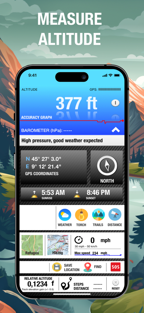
高度計GPSアプリのインターフェース。高度測定値とナビゲーションダッシュボードを表示。
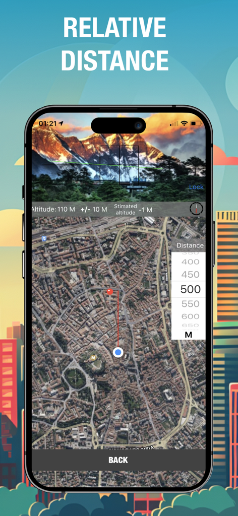
Altimeter GPSアプリ。衛星マップ上のユーザーの場所とターゲットポイント間の相対距離測定を表示。
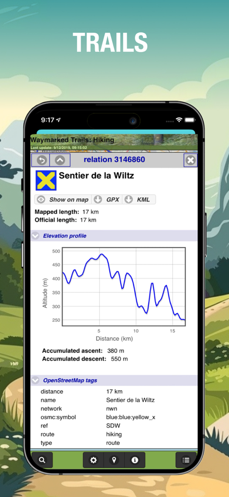
Altimeter GPSハイキングアプリの標高プロファイルグラフとトレイルデータ。
バックカントリーハイキングのためのAltimeter GPSアプリのナビゲーションマップインターフェース。
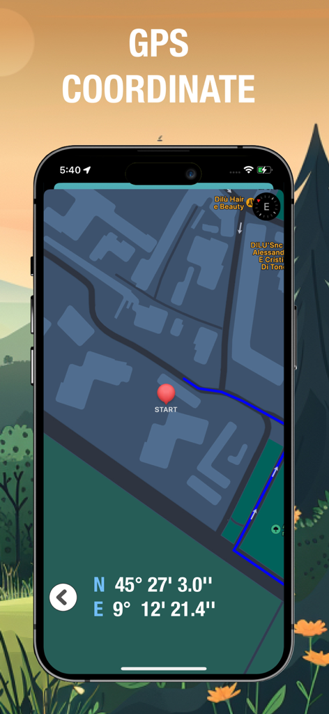
Altimeter GPSアプリのスマートフォン画面。ナビゲーションマップ上に正確な緯度と経度座標とルートマーカーを表示。
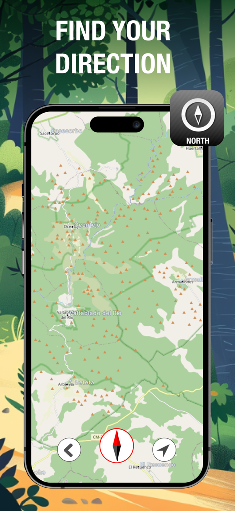
バックカントリーナビゲーションのための等高線マップとコンパスを表示するAltimeter GPSアプリ。
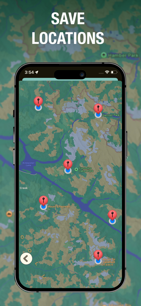
バックカントリーナビゲーションのために等高線マップ上に複数の保存されたウェイポイントを表示するAltimeter GPSアプリ。
説明
Download
類似アプリ
似た機能とユーザー体験を持つアプリ

经纬度指南针-测方位实时海拔天气相机
Guangzhou Duoyi Network Technology Co., Ltd.

My Altitude: GPS Altimeter
Enacti Ventures Private Limited

Compass & GPS
Seong Eon Kim

Compass App - Qibla finder
Simple Start Technologies

Compass & Coordinates Locator
ALVICOMP OU

Compass∞
Camera LLC(TX)

Compass - Professional
Peter Bohl

Elevation - Altimeter Map
Mapnitude Company Limited

Compass - GPS Altimeter
伟 雷
このページはアプリまたはその開発者の公式ページではなく、情報提供および論評を目的として作成された独立した編集出版物です。明示的に別段の記載がない限り、アプリおよびその開発者は、MWM、Apple、Google Play、アプリのパブリッシャー、またはアプリの開発者と提携、承認、後援、認可、またはその他の公式的な関係はなく、このページのいかなる内容も、アプリがMWMのサービスを使用して開発されたことを意味するものではありません。すべての商標、ロゴ、スクリーンショット、その他のコンテンツはそれぞれの所有者の財産です。