このページはアプリまたはその開発者の公式ページではなく、情報提供および論評を目的として作成された独立した編集出版物です。明示的に別段の記載がない限り、アプリおよびその開発者は、MWM、Apple、Google Play、アプリのパブリッシャー、またはアプリの開発者と提携、承認、後援、認可、またはその他の公式的な関係はなく、このページのいかなる内容も、アプリがMWMのサービスを使用して開発されたことを意味するものではありません。すべての商標、ロゴ、スクリーンショット、その他のコンテンツはそれぞれの所有者の財産です。

Elevation - Altimeter Map
アウトドアアドベンチャーや不動産の安全のためのプロフェッショナルな選択。クラウド、GPS、気圧計センサーを使用して正確な標高データにアクセスし、自信を持ってあらゆる地形をナビゲートします。
ダウンロード
1M+ユーザー評価
評価数
13K+開発元
カテゴリ
Navigation対応言語
14最新バージョン
4.13.2サイズ
63.4 MBリリース日
2011年11月22日あらゆる地形のための高精度ナビゲーション
山での最高のパフォーマンスから自宅での洪水リスクの評価まで、クラウド、GPS、気圧センサーを使用して、世界で最も正確な標高データを取得します。
トリプルソースの精度
クラウドデータ、GPS、および内蔵気圧センサーをシームレスに相互参照し、すべてのデバイスで最も正確な標高測定値を確認できます。
不動産と洪水インサイト
海抜からの正確な高さを評価することで、投資と安全を保護します。これは、洪水リスク監視と不動産調査に不可欠です。
よくある質問
について知っておくべきこと Elevation - Altimeter Map
Elevation - Altimeter Map アプリの主な機能は何ですか?
Elevation - Altimeter Map アプリは、ユーザーが現在の標高、高度、海抜の高さを把握するのに役立ちます。地球上のさまざまな場所の標高データを提供します。
Elevation - Altimeter Map はどのように標高を決定しますか?
Elevation - Altimeter Map アプリは、オンラインデータベース、内蔵GPS、またはデバイスの気圧計を使用して標高を決定します。ユーザーは住所を入力したり、地図を移動したりすることもできます。
Elevation - Altimeter Map を使用してGPS標高を測定できますか?
はい、Elevation - Altimeter Map は、デバイスの内蔵GPSを使用して現在地の高度を決定します。経路を記録し、多色の線で表示します。
Elevation - Altimeter Map は気圧高度測定をサポートしていますか?
はい、Elevation - Altimeter Map は、デバイスの内蔵気圧計を使用して標高を測定します。生気圧データまたは海面からの相対圧から測定し、多色の線で表示します。
Elevation - Altimeter Map はどの座標形式をサポートしていますか?
Elevation - Altimeter Map は、通常の緯度と経度、ユニバーサル横メルカトル座標(UTM)、およびミリタリーグリッド参照システム(MGRS)をサポートしています。
Elevation - Altimeter Map は高度と気圧データをエクスポートできますか?
はい、Elevation - Altimeter Map では、タイムスタンプ、高度、気圧、座標などの情報をエクスポートできます。
Elevation - Altimeter Map は無料でダウンロードして使用できますか?
はい、Elevation - Altimeter Map はすべての機能が完全に無料で利用できます。広告の削除とデータ遅延の短縮のためのオプションのサブスクリプションも利用可能です。
Elevation - Altimeter Map のサブスクリプション費用はいくらですか?
Elevation - Altimeter Map のサブスクリプションは、月額4.49ドル、6ヶ月で25.99ドル、年間48.99ドルです。価格は地域によって異なります。
Elevation - Altimeter Map のサブスクリプションにはどのような機能がありますか?
Elevation - Altimeter Map をサブスクライブすると、広告が削除され、データ取得遅延が50%短縮されます。その他のすべてのアプリ機能は無料のままです。
Elevation - Altimeter Map をスタンドアロン気圧計として使用できますか?
はい、Elevation - Altimeter Map はスタンドアロン気圧計として機能し、デバイスで気圧を測定できます。
Elevation - Altimeter Map には気圧・高度計算機が含まれていますか?
はい、Elevation - Altimeter Map には「気圧 / 高度計算機」が搭載されています。既知の高度、気圧、温度、海面気圧から大気圧および/または高度を計算します。
Elevation - Altimeter Map を使用して2つの場所間の高度を比較するにはどうすればよいですか?
Elevation - Altimeter Map は、高度比較のために「レンジモード」を提供しています。この機能は、選択した2つの場所間の標高のグラフと線表示を提供します。
以下のスクリーンショットと説明は、アプリの公式ストアリスティングから直接取得されたものであり、アプリ開発者の所有物です。
アプリストア
スクリーンショット
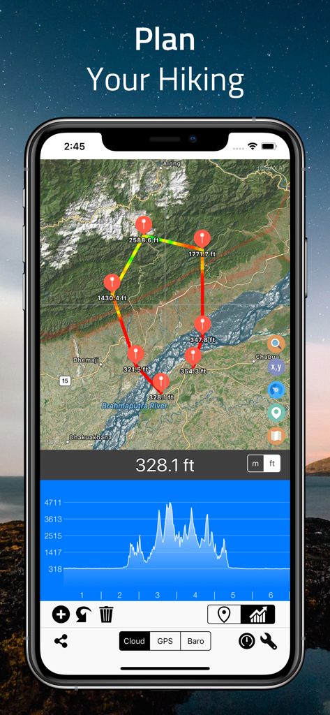
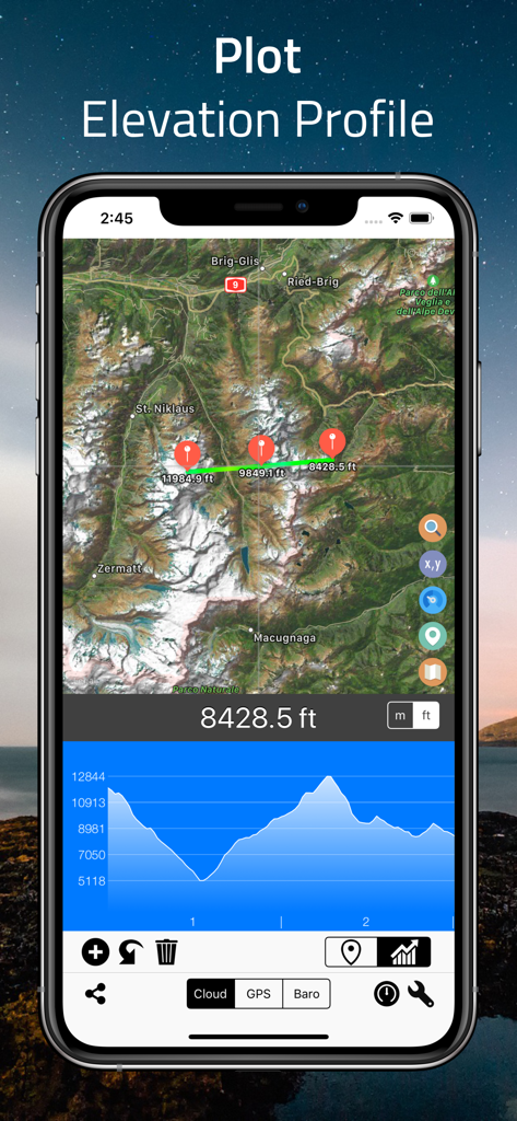
Elevation Altimeter Mapアプリのインターフェース。衛星マップと標高プロファイルグラフを備えたハイキングルート計画画面を表示しています。
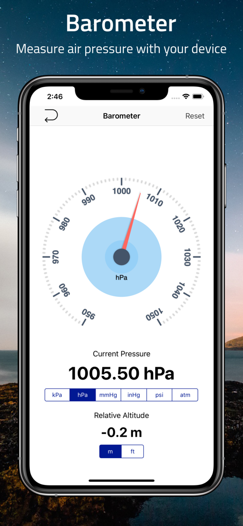
スマートフォンがElevation Altimeter Mapアプリの気圧計機能を表示しており、気圧と相対高度が表示されています。
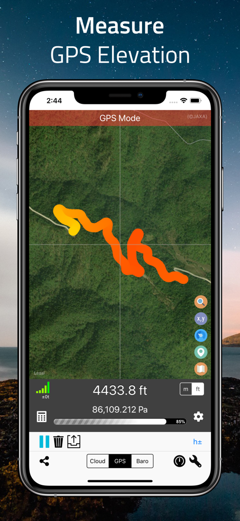
Elevation AltimeterアプリがGPSモードで表示されているスマートフォン。衛星マップ上に4433.8フィートの標高を示す多色トラックが表示されています。
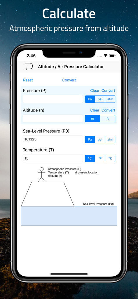
モバイルアプリのインターフェース。気圧高度と温度のフィールドを備えた高度と気圧計算機を表示しています。
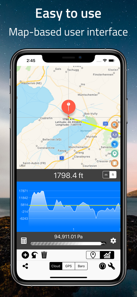
Elevation Altimeter Mapアプリのスクリーンショット。標高データと地形プロファイルグラフを備えたマップインターフェースを表示しています。
Elevation Altimeter Mapアプリのインターフェース。標高プロットと標高グラフを備えた衛星マップを表示しています。
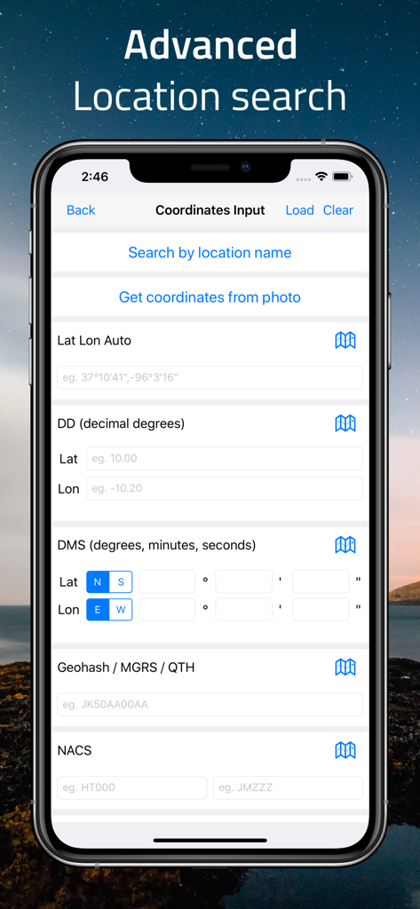
GPS DMSやMGRSなどのさまざまな形式での手動座標入力のための高度な場所検索画面。
説明
Download
類似アプリ
似た機能とユーザー体験を持つアプリ

经纬度指南针-测方位实时海拔天气相机
Guangzhou Duoyi Network Technology Co., Ltd.

My Altitude: GPS Altimeter
Enacti Ventures Private Limited

Compass & GPS
Seong Eon Kim

Compass App - Qibla finder
Simple Start Technologies

Compass & Coordinates Locator
ALVICOMP OU

Compass∞
Camera LLC(TX)

Compass - Professional
Peter Bohl

Altimeter GPS & Barometer
Andrea Terdich

Compass - GPS Altimeter
伟 雷
このページはアプリまたはその開発者の公式ページではなく、情報提供および論評を目的として作成された独立した編集出版物です。明示的に別段の記載がない限り、アプリおよびその開発者は、MWM、Apple、Google Play、アプリのパブリッシャー、またはアプリの開発者と提携、承認、後援、認可、またはその他の公式的な関係はなく、このページのいかなる内容も、アプリがMWMのサービスを使用して開発されたことを意味するものではありません。すべての商標、ロゴ、スクリーンショット、その他のコンテンツはそれぞれの所有者の財産です。