このページはアプリまたはその開発者の公式ページではなく、情報提供および論評を目的として作成された独立した編集出版物です。明示的に別段の記載がない限り、アプリおよびその開発者は、MWM、Apple、Google Play、アプリのパブリッシャー、またはアプリの開発者と提携、承認、後援、認可、またはその他の公式的な関係はなく、このページのいかなる内容も、アプリがMWMのサービスを使用して開発されたことを意味するものではありません。すべての商標、ロゴ、スクリーンショット、その他のコンテンツはそれぞれの所有者の財産です。

FishAngler - Fish Finder App
100万人以上の釣り人が愛用。プロ仕様のGarmin Navionicsチャート、AI魚種識別、リアルタイム予報を活用して、あらゆる釣行を成功に導きましょう。
ダウンロード
1M+ユーザー評価
評価数
18K+開発元
カテゴリ
Sports対応言語
32最新バージョン
4.6.6サイズ
304.1 MBリリース日
2016年7月11日現代の釣り人のための精密ツール
当て推量をやめて、確実に釣りましょう。プロ仕様のマップ、リアルタイムの予報、AIによる洞察を組み合わせて、あらゆるフィールドを攻略しましょう。
プロ仕様のマップと予報
Garmin Navionicsの水深チャートでナビゲートし、潮汐、風、月相をライブで追跡。外科手術のような正確さで釣行のタイミングを計れます。
プライベートログブックとウェイポイント
個人の釣果データベースを構築し、お気に入りのスポットを完全なプライバシー管理でマーク。あなただけの「秘密のポイント」は常に守られます。
よくある質問
について知っておくべきこと FishAngler - Fish Finder App
FishAnglerアプリとは何ですか?
FishAnglerは、強力な釣り用マップ、天気予報、コミュニティツールを提供する総合的な釣りアプリです。バス、マス、海水魚など、さまざまな魚種のスポット発見、釣行計画、釣果記録に役立ちます。
FishAnglerアプリは釣り用マップを提供していますか?
はい、FishAnglerアプリは、数百万件の検証済み釣果場所、ボートランプ、リーフ、水中構造物を含む釣り用マップを提供しています。ユーザーはこれらのマップ上にプライベートウェイポイントをマークして管理することもできます。
FishAnglerで釣りの状況を追跡できますか?
はい、FishAnglerは潮汐、風、月齢、気圧、時間ごとの魚の活動を含む包括的な釣り予報を提供しています。これにより、ユーザーはリアルタイムの状況に基づいて効果的に釣行を計画できます。
FishAnglerには釣果記録用のログブックがありますか?
はい、FishAnglerアプリには、魚種、タックル、天気、個人の統計などの詳細を記録するための個人用ログブックが含まれています。これにより、アングラーはパターンを分析し、釣果を向上させることができます。
FishAnglerアプリは魚種を特定するのにどのように役立ちますか?
FishAnglerアプリには、独自のAI魚種識別ツールが含まれています。このツールは、300種以上の淡水魚および海水魚を瞬時に識別し、アングラーの魚の認識を支援します。
FishAnglerは無料アプリですか?
はい、FishAnglerアプリは無料でダウンロードして使用でき、追加費用なしで主要機能にアクセスできます。より高度なツールと広告なしのエクスペリエンスを利用するには、オプションのVIPアップグレードが用意されています。
FishAngler VIPで利用できるプレミアム機能は何ですか?
FishAngler VIPは、正確な釣果場所、HD深度チャート、Garmin Navionicsによる湖の等深線、プライベートウェイポイント、3Dマップ、広告なしのブラウジングをアンロックします。これらの機能は、加入者の釣り体験を向上させます。
FishAnglerで釣り場をプライベートに保つことはできますか?
はい、FishAnglerでは、お気に入りの釣り場をプライベートウェイポイントとしてマークおよび管理できます。アプリはこれらの場所に関する完全なプライバシー管理を提供し、個人の場所が機密であることを保証します。
FishAnglerは餌やルアーのおすすめを提供していますか?
はい、FishAnglerは餌&ルアーインサイトを提供しています。この機能は、近くで魚を釣っているアングラーに現在効果のある餌やルアーを示し、最適なタックルを選択するのに役立ちます。
FishAnglerで他のアングラーとどのようにつながることができますか?
FishAnglerは、他のアングラーとつながるためのコミュニティ機能を提供しています。グループに参加したり、チャレンジに参加したり、新しい釣り仲間と出会ったり、アプリ内で直接釣りのヒントを共有したりできます。
FishAnglerアプリで深度チャートは利用できますか?
はい、FishAnglerはGarmin Navionicsチャートや等深線を含むHD深度&海図を提供しています。これらのプレミアムレイヤーは、淡水および海水で利用でき、VIPアップグレードでアクセスできます。
FishAnglerは釣りに最適な時間を教えてくれますか?
はい、FishAnglerのスマート釣り予報は、時間ごとの魚の活動を予測します。潮汐、風、月齢などの要因を組み合わせて、特定の場所での釣りに最適な時間を示します。
以下のスクリーンショットと説明は、アプリの公式ストアリスティングから直接取得されたものであり、アプリ開発者の所有物です。
アプリストア
スクリーンショット
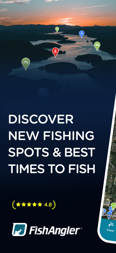
夕暮れ時の湖にある釣りスポットのマーカーと4.8の星評価が表示されたFishAnglerアプリのスクリーンショット
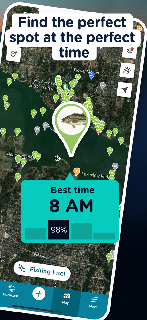
釣りスポットの地図と、午前8時が釣りに最適な時間であることを示す予報が表示されたFishAnglerアプリの画面。
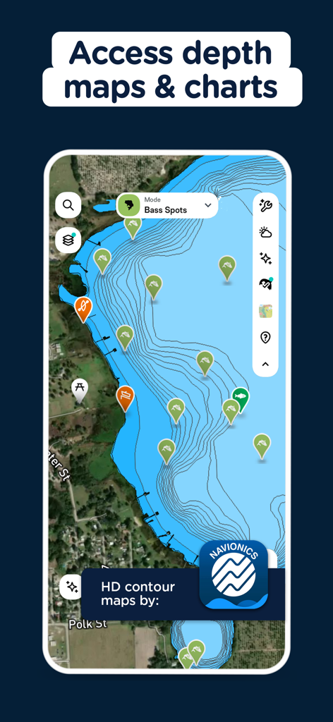
NavionicsによるHD等深線水深マップと釣りスポットのマーカーが表示されたFishAnglerアプリのインターフェース
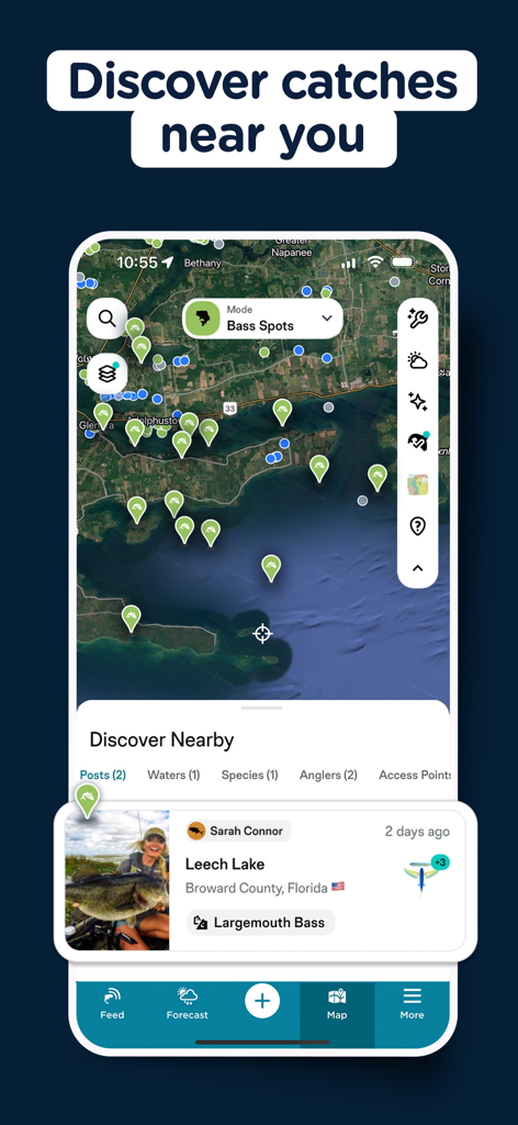
確認済みの釣果場所と、フロリダで釣れたラージマウスバスのレポートが表示されたFishAnglerアプリのマップビュー
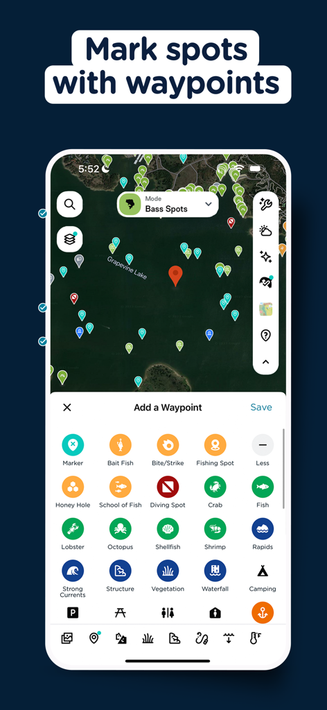
さまざまなカスタムウェイポイントマーカーとウェイポイント追加メニューが表示されたサテライト釣りマップのFishAnglerアプリインターフェース。
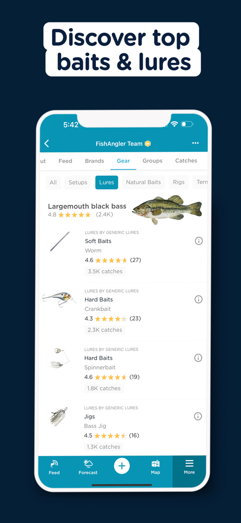
ユーザーの釣果データに基づいたラージマウスブラックバスの最高評価の餌とルアーを表示するFishAnglerアプリの画面。
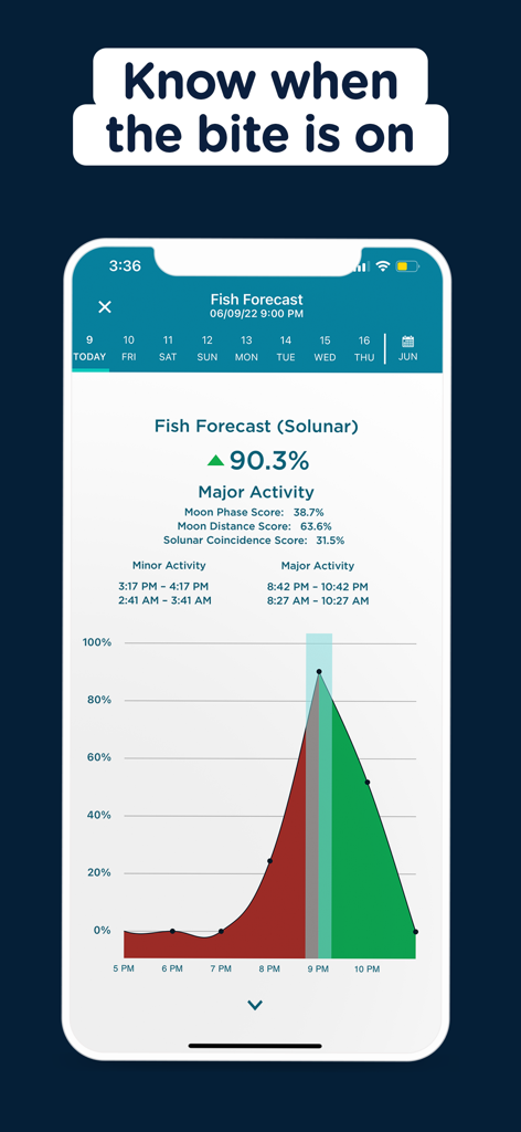
潮汐・月齢(ソルナー)の魚の活性予報と主要なバイトタイムのグラフを表示するFishAnglerアプリのインターフェース
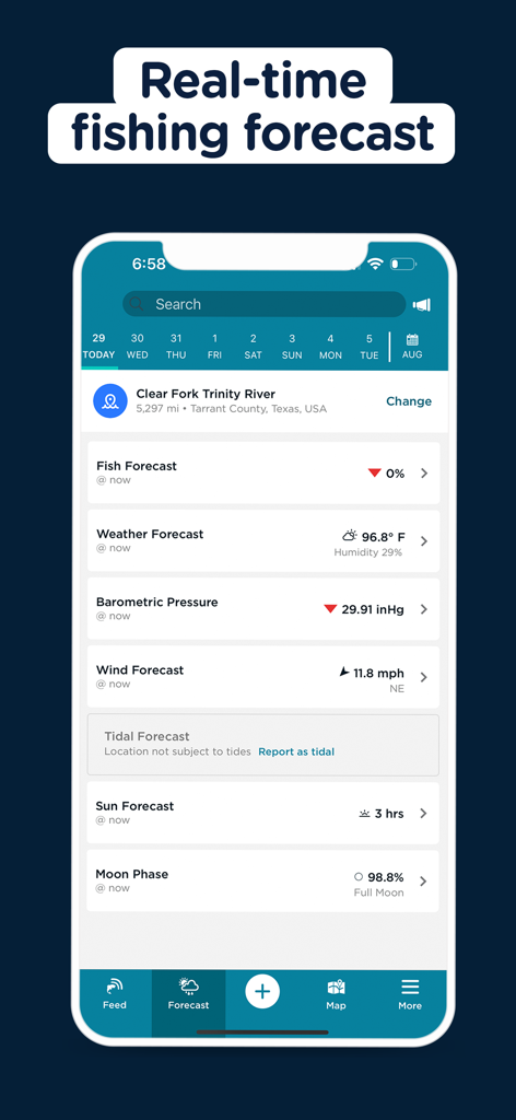
天気、風、気圧、月相データを表示するFishAnglerアプリのリアルタイム釣り予報画面
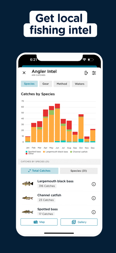
地域の釣りデータと魚種別釣果統計チャートを表示するFishAnglerアプリ
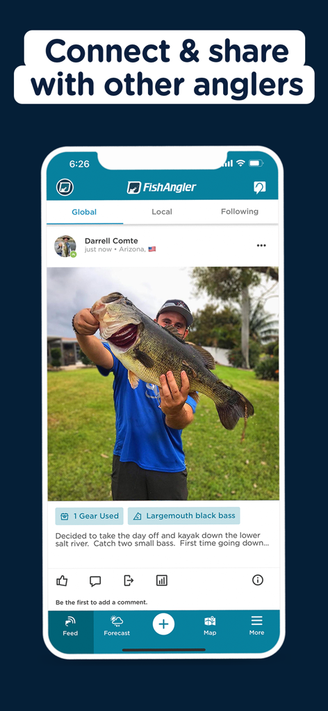
FishAnglerのソーシャルフィードでラージマウスバスの釣果写真を共有する釣り人。
説明
Download
類似アプリ
似た機能とユーザー体験を持つアプリ

钓鱼天气预报
Hefei Sasha Technology Co., Ltd.

潮汐表-潮汐天气预报&钓鱼潮汐天气工具助手
荣虎 太

Fishbrain - Fishing App
FishBrain AB

Fishing Points: Map & Forecast
Fishing Points d.o.o.

onX Fish: Midwest Lake Finder
onXmaps, Inc.

Fishbox - Smart Fishing App
MEMS Group, Inc.

釣果記録FishRanker-フィッシュランカー,釣り,分析
SIIG Inc.

Fish Deeper - Fishing App
Deeper UAB

BigBlue Offshore Fishing
GeoPelagic LLC
このページはアプリまたはその開発者の公式ページではなく、情報提供および論評を目的として作成された独立した編集出版物です。明示的に別段の記載がない限り、アプリおよびその開発者は、MWM、Apple、Google Play、アプリのパブリッシャー、またはアプリの開発者と提携、承認、後援、認可、またはその他の公式的な関係はなく、このページのいかなる内容も、アプリがMWMのサービスを使用して開発されたことを意味するものではありません。すべての商標、ロゴ、スクリーンショット、その他のコンテンツはそれぞれの所有者の財産です。