このページはアプリまたはその開発者の公式ページではなく、情報提供および論評を目的として作成された独立した編集出版物です。明示的に別段の記載がない限り、アプリおよびその開発者は、MWM、Apple、Google Play、アプリのパブリッシャー、またはアプリの開発者と提携、承認、後援、認可、またはその他の公式的な関係はなく、このページのいかなる内容も、アプリがMWMのサービスを使用して開発されたことを意味するものではありません。すべての商標、ロゴ、スクリーンショット、その他のコンテンツはそれぞれの所有者の財産です。

Fishing Points: Map & Forecast
1200万人の釣り人が、プロ級の海図、ソルーナー摂食時間、詳細な気象データを利用して、計画、航行、そしてより多くの魚を釣っています。
ダウンロード
2M+ユーザー評価
評価数
66K+開発元
カテゴリ
Sports対応言語
11最新バージョン
3.1.2サイズ
217.1 MBリリース日
2017年4月17日データに基づいた洞察で水域をマスター
高解像度の海図から正確な摂食予測まで、魚を出し抜き、すべての釣行を最適化するために必要なすべてを手に入れましょう。
高精度スポットマッピング
NOAA海図と詳細な水深等高線で隠れたホットスポットを見つけ、完璧な水中構造を狙いましょう。
スマートな摂食予測
ソルーナーサイクル、潮汐、気圧を追跡して活動のピーク期間を特定し、釣果を最大化しましょう。
よくある質問
について知っておくべきこと Fishing Points: Map & Forecast
Fishing Points は、ユーザーが最高の釣り時間をどのように見つけるのに役立ちますか?
Fishing Points は、潮汐、月の満ち欠け、海洋、ソルナー、気象データを分析することで、詳細な釣り予報を提供します。 hourly feeding times(毎時間の餌付け時間)、daily fish activity(毎日の魚の活動)、そして人気のある魚種の best fishing times calendar(最適な釣り時間カレンダー)を提供します。
Fishing Points アプリで利用できる地図の種類は何ですか?
Fishing Points は、詳細な衛星釣り地図、世界中の海図、オフラインの海洋海図(NOAA)を含む4種類の地図を提供しています。また、海草、牡蠣礁、マングローブ、水深と等深線図を備えた湖の地図のレイヤーも特徴としています。
Fishing Points で釣り場やトローリングルートを保存できますか?
はい、Fishing Points では釣り場、場所、ホットスポット、ウェイポイントを保存できます。トローリングルートやトロットラインの記録もサポートしており、GPSで保存した場所を簡単に見つけることができます。
Fishing Points は、水位や流量などの河川データを提供しますか?
はい、Fishing Points は 35,000 以上の河川観測所で現在の水位と流量を提供します。この機能は、釣り人が河川の状況を監視し、釣りの計画に役立てるのに役立ちます。
ユーザーは Fishing Points アプリ内で釣果を記録できますか?
はい、Fishing Points にはプライベートな釣果記録帳が含まれています。ユーザーは、写真、重量、長さ、自動的に追加される天気、ソルナー、潮汐情報を含む、すべての釣果の詳細を保存できます。
Fishing Points は地図のオフライン機能を提供していますか?
はい、Fishing Points は NOAA によって提供される海洋海図を備えたオフラインモードを提供しています。この機能により、ユーザーはインターネット接続がない場合でも、重要な地図データにアクセスできます。
世界中で何人の釣り人が Fishing Points アプリを使用していますか?
Fishing Points は、世界中で 1200 万人以上の釣り人を繋いでいます。このグローバルコミュニティには、釣りの体験を向上させたい塩水と淡水の両方の釣り人が含まれています。
Fishing Points は潮汐予測や海洋予報を表示しますか?
はい、Fishing Points は、満潮と干潮の情報を含む hourly tides charts(毎時間の潮汐チャート)と、詳細な潮汐流予測を表示します。また、波、海水温、海流の海洋予報も提供します。
Fishing Points のデータを複数のデバイス間で同期できますか?
はい、Fishing Points では、保存したデータをすべてのコンピューターおよびモバイルデバイス間で同期できます。コンピューターで釣り旅行を計画および分析するための Webapp も利用できます。
Fishing Points は雨レーダー機能を提供していますか?
はい、Fishing Points には雨レーダー機能が含まれています。これにより、ユーザーはライブの激しい気象警報を表示し、地図上で雨の強さを追跡でき、より良い旅行計画に役立ちます。
以下のスクリーンショットと説明は、アプリの公式ストアリスティングから直接取得されたものであり、アプリ開発者の所有物です。
アプリストア
スクリーンショット
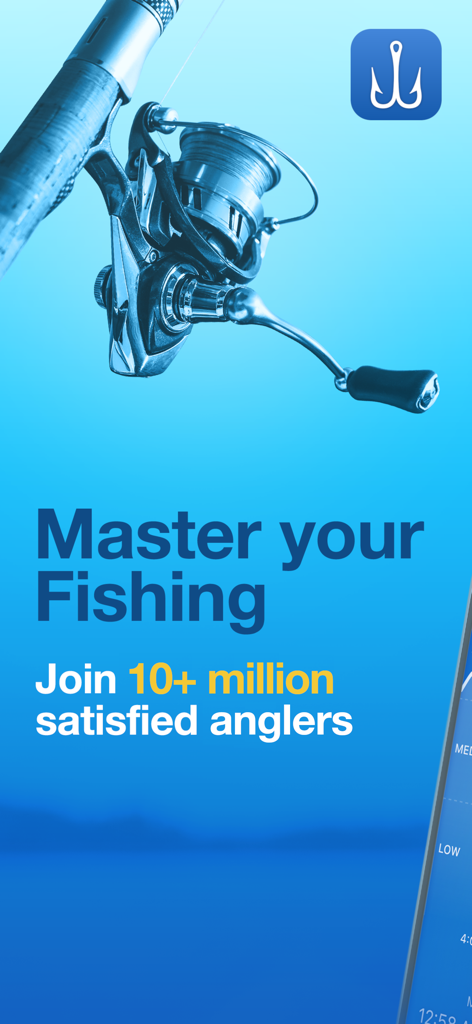
フィッシングリールと「Master your Fishing」の文字が特徴のFishing Pointsアプリのプロモーション画像。
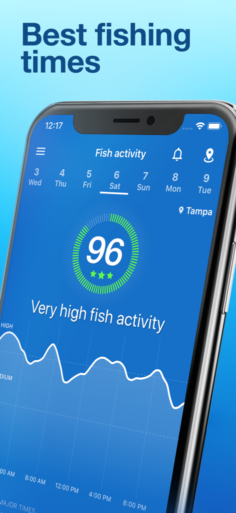
高い魚の活動予測と最高の釣り時間グラフを表示するFishing Pointsアプリのインターフェース。
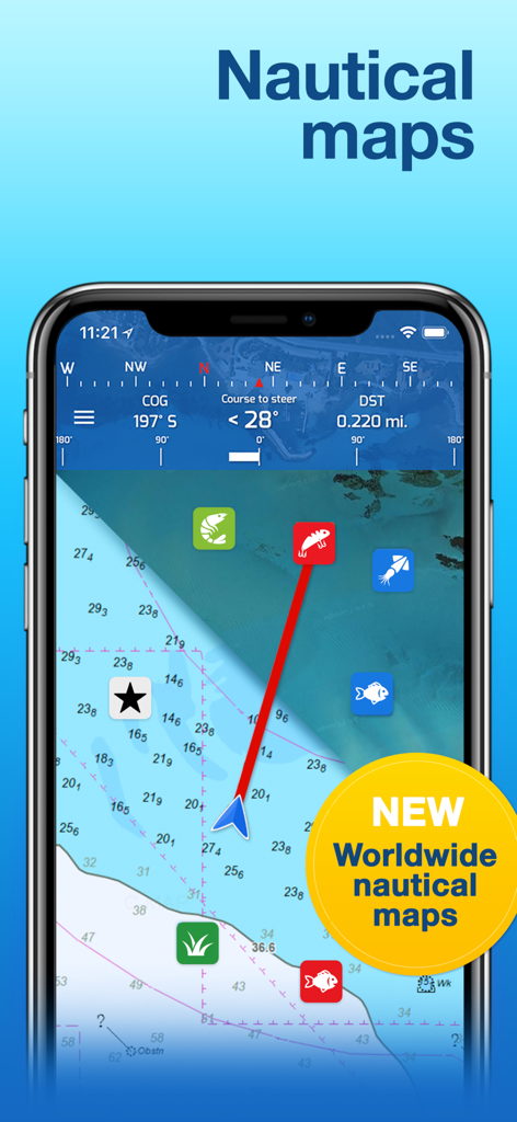
水深等高線とナビゲーションウェイポイントを含む詳細な世界各地の海図を表示するFishing Pointsアプリのインターフェース。
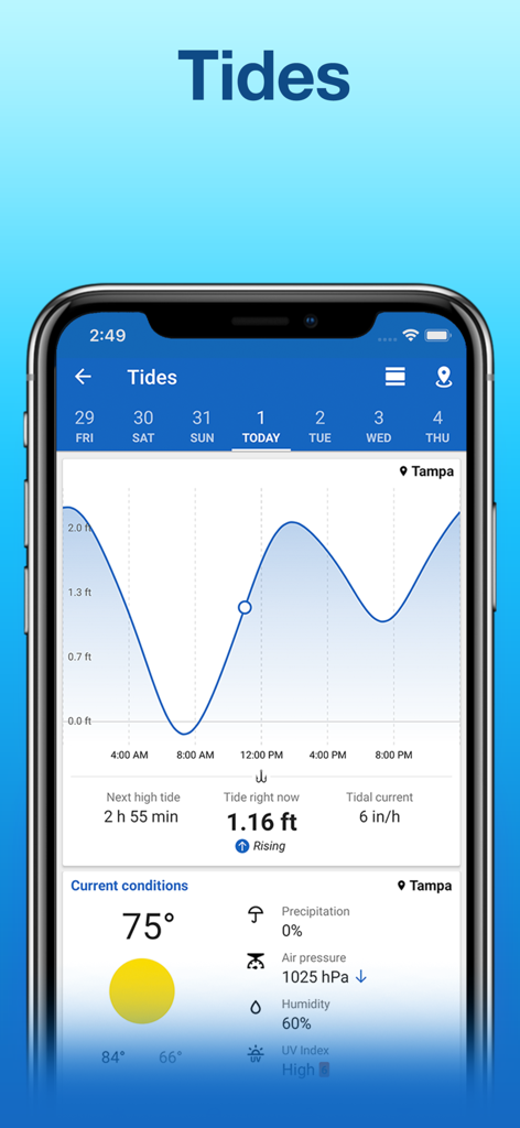
フロリダ州タンパの潮汐予測と天気予報を表示するFishing Pointsアプリのインターフェース。
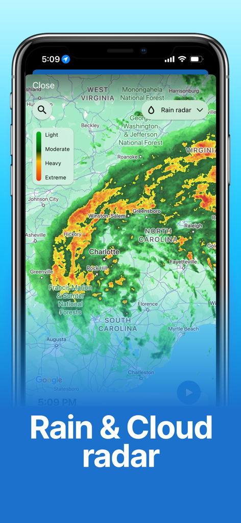
ノースカロライナ州とサウスカロライナ州上空のライブ雨雲レーダー予測マップを表示するFishing Pointsアプリ。
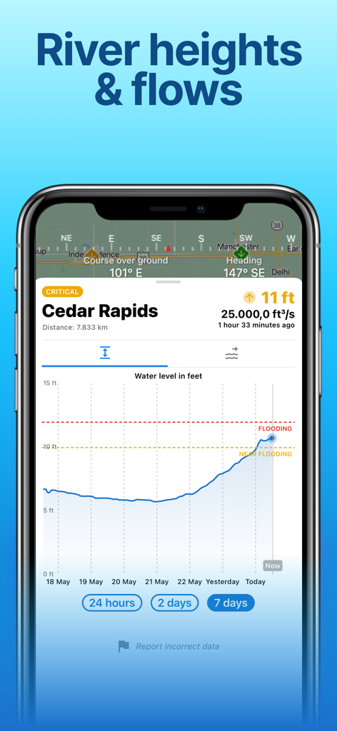
シーダーラピッズの洪水警報付き河川水位チャートを表示するモバイルアプリ画面。
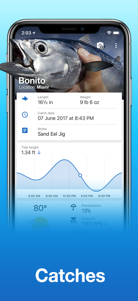
カツオの釣果ログ(長さ、重さ、潮位グラフなどの詳細を含む)を表示するFishing Pointsアプリ画面。
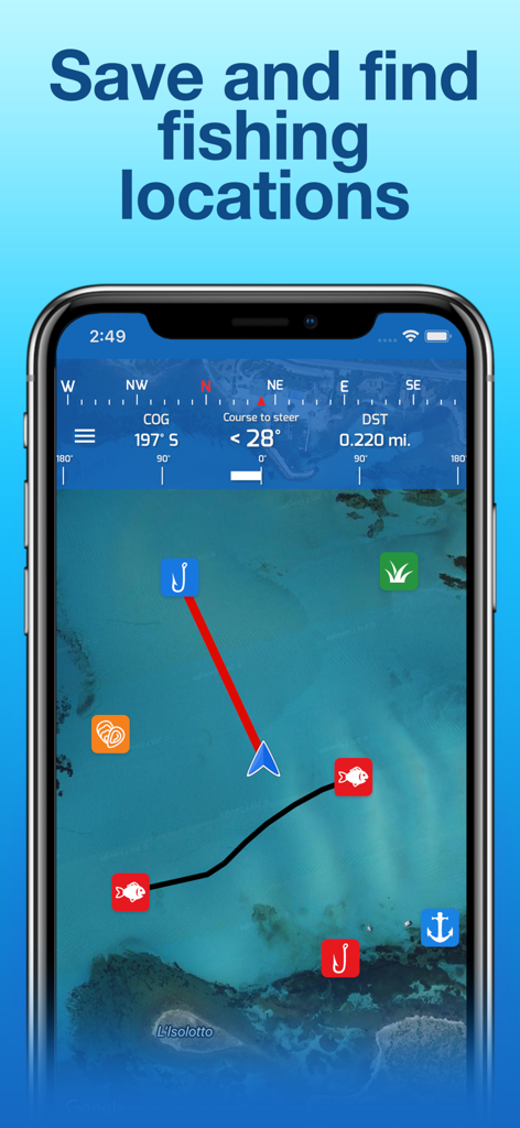
海図と保存された釣り場所が表示されたFishing Pointsアプリのスマートフォン画面。
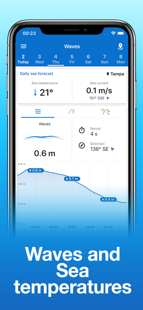
Fishing Pointsアプリで波の高さと海水温の予測を表示する携帯電話。
説明
Download
類似アプリ
似た機能とユーザー体験を持つアプリ

FishAngler - Fish Finder App
FishAngler, LLC

钓鱼天气预报
Hefei Sasha Technology Co., Ltd.

潮汐表-潮汐天气预报&钓鱼潮汐天气工具助手
荣虎 太

Fishbrain - Fishing App
FishBrain AB

onX Fish: Midwest Lake Finder
onXmaps, Inc.

Fishbox - Smart Fishing App
MEMS Group, Inc.

釣果記録FishRanker-フィッシュランカー,釣り,分析
SIIG Inc.

Fish Deeper - Fishing App
Deeper UAB

BigBlue Offshore Fishing
GeoPelagic LLC
このページはアプリまたはその開発者の公式ページではなく、情報提供および論評を目的として作成された独立した編集出版物です。明示的に別段の記載がない限り、アプリおよびその開発者は、MWM、Apple、Google Play、アプリのパブリッシャー、またはアプリの開発者と提携、承認、後援、認可、またはその他の公式的な関係はなく、このページのいかなる内容も、アプリがMWMのサービスを使用して開発されたことを意味するものではありません。すべての商標、ロゴ、スクリーンショット、その他のコンテンツはそれぞれの所有者の財産です。