このページはアプリまたはその開発者の公式ページではなく、情報提供および論評を目的として作成された独立した編集出版物です。明示的に別段の記載がない限り、アプリおよびその開発者は、MWM、Apple、Google Play、アプリのパブリッシャー、またはアプリの開発者と提携、承認、後援、認可、またはその他の公式的な関係はなく、このページのいかなる内容も、アプリがMWMのサービスを使用して開発されたことを意味するものではありません。すべての商標、ロゴ、スクリーンショット、その他のコンテンツはそれぞれの所有者の財産です。

GPS Maps Camera
写真に撮った瞬間、その場所、その時のあらゆる情報が写真の一部になる。単なる写真ではない、生きた記録を掴み取れ。
ダウンロード
750k+ユーザー評価
評価数
92開発元
カテゴリ
Navigation対応言語
21最新バージョン
2.0サイズ
35.2 MBリリース日
2024年7月17日高精度な位置情報と環境データを統合する写真撮影ツールの評価
「GPS Maps Camera」アプリ分析レポート
GPS座標の詳細な埋め込み
このアプリは、写真にGPS座標を小数、MGRS、またはUTM形式で正確に埋め込むことを可能にし、専門的な測量や地理空間分析に不可欠な精密な位置情報を提供します。
環境データの自動付与
本ツールは、温度、風速、気圧、方位、磁場、高度といった多様な環境データを写真に自動的に付与し、撮影時の包括的な状況記録をサポートします。
多様な地図表示と位置情報管理
ユーザーは、ノーマル、衛星、ハイブリッドといった様々な地図タイプを選択できるほか、現在の位置情報や手動設定による位置情報を写真に記録し、正確なジオタグ付けを実現します。
柔軟な情報スタンプのカスタマイズ
このアプリは、ユーザーがテンプレートを選択し、日付、時刻、住所、各種測定単位など、写真に表示されるスタンプ情報を自由にカスタマイズ・配置することを可能にします。
高精度な日時とタイムゾーン記録
本ツールは、様々な形式での日付と時刻の表示に加え、任意のタイムゾーン選択機能を備えており、国際的なプロジェクトや旅行においても正確な時間情報を写真に記録します。
詳細なカメラ設定オプション
このアプリは、グリッド表示、アスペクト比の選択、フロント/バックカメラの切り替え、フラッシュ、フォーカス調整、タイマー設定など、写真撮影を最適化するための豊富なカメラオプションを提供します。
よくある質問
について知っておくべきこと GPS Maps Camera
What is the GPS Maps Camera app?
The GPS Maps Camera app captures and customizes photos with detailed map data, weather conditions, and various informational stamps. It is designed for photographers, travelers, and outdoor enthusiasts.
Can I manually add GPS coordinates to photos using GPS Maps Camera?
Yes, the GPS Maps Camera app allows users to manually set GPS coordinates and location data for their photos. This feature is available in the Map Data section of the app.
What customization options does the GPS Maps Camera app offer for templates?
The GPS Maps Camera app offers various template customization options, including different map types, address formats, GPS coordinate formats (Decimal, MGRS, UTM), date/time formats, and weather information units.
Does GPS Maps Camera display weather information on photo stamps?
Yes, the GPS Maps Camera app displays weather information directly on photo stamps. Users can choose to show temperature in Fahrenheit or Celsius and wind speed in their preferred units.
How can I manage my photos within the GPS Maps Camera app?
After capturing images with a stamp, the GPS Maps Camera app allows users to easily delete, share, or save photos to their gallery. It also includes a QR code scanning feature.
What are the subscription terms for the GPS Maps Camera app?
The GPS Maps Camera app subscription automatically renews unless turned off 24 hours before the period ends. Payment is charged to the iTunes Account, and no cancellation is allowed during an active subscription.
Can I choose different map views in the GPS Maps Camera templates?
Yes, the GPS Maps Camera app allows users to switch between Normal, Satellite, and Hybrid map views within the advanced template options. This enhances the visual context of geotagged photos.
Does the GPS Maps Camera app automatically calculate altitude and accuracy?
Yes, the GPS Maps Camera app automatically calculates and displays altitude. It also provides accuracy details in two formats, ensuring precise geotagging information for your captured images.
以下のスクリーンショットと説明は、アプリの公式ストアリスティングから直接取得されたものであり、アプリ開発者の所有物です。
アプリストア
スクリーンショット
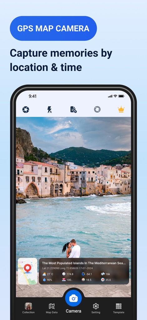
このアプリは、美しい風景写真に現在地と時刻の詳細なスタンプを自動で埋め込み、思い出を鮮やかに記録できます。ユーザーは撮影場所の地図データと正確な日時情報を視覚的に確認できます。
位置情報で記録
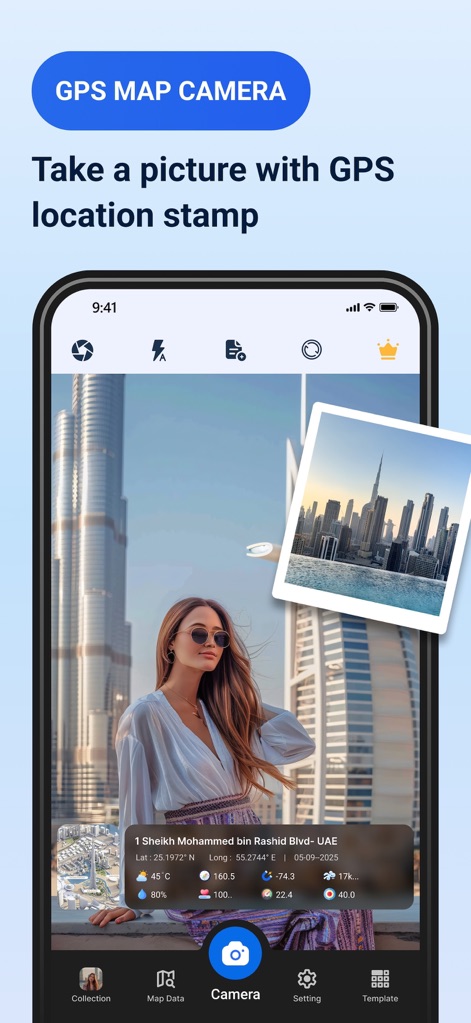
このスクリーンショットは、ユーザーが撮影した写真に自動でGPS位置情報スタンプを付与する機能を示しています。写真の下部に位置情報と日付が視覚的に表示され、撮影時の状況を正確に記録できます。
正確なジオタグ
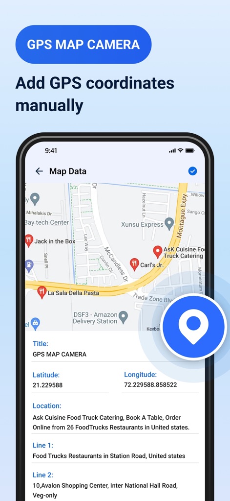
本ツールは、ユーザーがGPS座標と詳細な住所を手動で入力できるインターフェースを提供します。表示された地図上で場所を視覚的に特定し、緯度・経度を直接編集して正確な位置情報を設定できます。
手動で位置設定
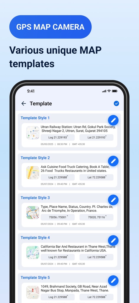
このアプリは、写真に埋め込むための多様な地図情報テンプレートを提供します。ユーザーは異なるレイアウトと情報表示オプションを持つ複数のテンプレートスタイルから選択し、好みに合わせてカスタマイズできます。
多様な地図テンプレート
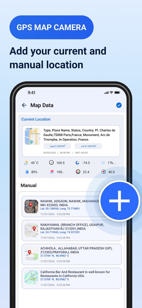
この画面では、ユーザーは現在地の詳細情報(気象データを含む)を即座に確認できます。また、過去に手動で保存した複数の位置情報がリスト形式で表示され、それらを簡単に選択・追加できます。
位置データを管理
説明
Download
類似アプリ
似た機能とユーザー体験を持つアプリ

Timestamp Camera -AI Timestamp
Shanghai Zongchong Information Technology Co., Ltd

Timestamp Camera - Date Stamp
Artify Inc.

Timestamp Camera: Time & GPS
Practical Apps from Sweden AB

Timestamp camera - gps cam
Guangzhou Siyue Network Technology Co., Ltd.

DateStamper
Jordan Hipwell

Timestamp Camera Basic
玉彬 陈

GPS Map Camera : Geo Photos
Chirag Gabani

Timestamp Camera: Time stamp
燕倩 费

Timestamp Camera - Time & GPS
Shaanxi Ruidebao Technology Co.,Ltd
このページはアプリまたはその開発者の公式ページではなく、情報提供および論評を目的として作成された独立した編集出版物です。明示的に別段の記載がない限り、アプリおよびその開発者は、MWM、Apple、Google Play、アプリのパブリッシャー、またはアプリの開発者と提携、承認、後援、認可、またはその他の公式的な関係はなく、このページのいかなる内容も、アプリがMWMのサービスを使用して開発されたことを意味するものではありません。すべての商標、ロゴ、スクリーンショット、その他のコンテンツはそれぞれの所有者の財産です。