このページはアプリまたはその開発者の公式ページではなく、情報提供および論評を目的として作成された独立した編集出版物です。明示的に別段の記載がない限り、アプリおよびその開発者は、MWM、Apple、Google Play、アプリのパブリッシャー、またはアプリの開発者と提携、承認、後援、認可、またはその他の公式的な関係はなく、このページのいかなる内容も、アプリがMWMのサービスを使用して開発されたことを意味するものではありません。すべての商標、ロゴ、スクリーンショット、その他のコンテンツはそれぞれの所有者の財産です。

Maptrails
オフライン地形図、テクニカルGISレイヤー、iPhone、iPad、Mac、Apple Watch間のシームレスな同期でアウトドアをマスターしましょう。ハイキング、ハンティング、探索に必要なすべての機能が、サブスクリプションの煩わしさなしで利用できます。
ダウンロード
30K+ユーザー評価
評価数
300開発元
カテゴリ
Navigation対応言語
11最新バージョン
2025.7.2サイズ
28.0 MBリリース日
2020年8月2日本格的な冒険者のための高度なナビゲーション
Maptrailsは、サブスクリプションなしで、テクニカルハイカー、ハンター、ナビゲーターのためにプロフェッショナルグレードのマッピングとシームレスなAppleエコシステム統合を提供します。
シームレスなAppleエコシステム同期
MacまたはiPadでApple Pencilサポートを使用してトレッキングを計画し、iPhoneとApple Watchで即時のiCloud同期を通じて自信を持ってナビゲートしましょう。
プロフェッショナルデータとオフラインマップ
GPX、KML、Shapefileをインポートして精密な計画を立てましょう。最も奥地のバックカントリーでも100%オフラインで信頼できるマップタイルをダウンロードしましょう。
サブスクリプションなし、パワーだけ
ドッグトラッキングやカスタムマップレイヤーなどの専門ツールを、一度だけの購入でアンロックしましょう。ナビゲーションツールを借りるのではなく、所有しましょう。
サブスクリプションなし、パワーだけ
ドッグトラッキングやカスタムマップレイヤーなどの専門ツールを、一度だけの購入でアンロックしましょう。ナビゲーションツールを借りるのではなく、所有しましょう。
以下のスクリーンショットと説明は、アプリの公式ストアリスティングから直接取得されたものであり、アプリ開発者の所有物です。
アプリストア
スクリーンショット
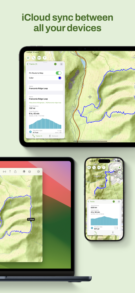
MaptrailsアプリのインターフェースをiPad、Mac、iPhoneに表示し、ハイキングマップとトラックのiCloud同期を示しています。
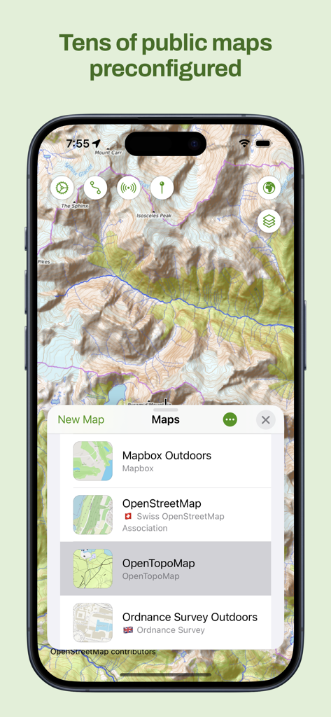
MaptrailsアプリのiPhoneスクリーンショットで、地形図とOpenTopoMapのような事前設定された公開マップのリストが表示されています。
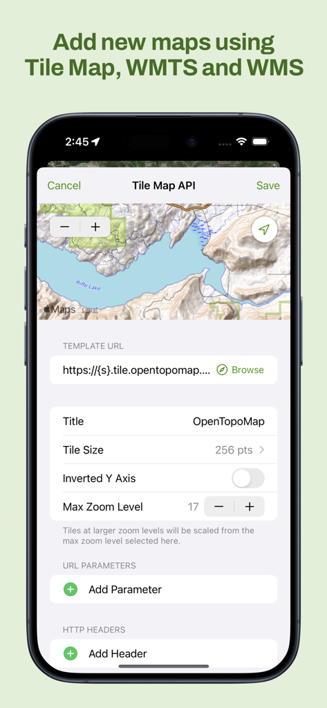
Maptrailsアプリのインターフェースで、カスタムタイルマップWMTSおよびWMSレイヤーを追加しています。
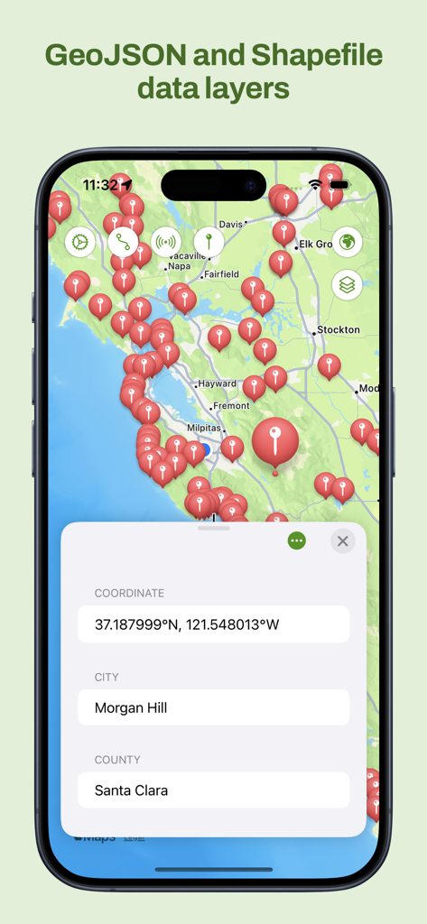
Maptrailsアプリのインターフェースで、GeoJSONおよびShapefileマップレイヤー、場所のピン、座標を表示しています。
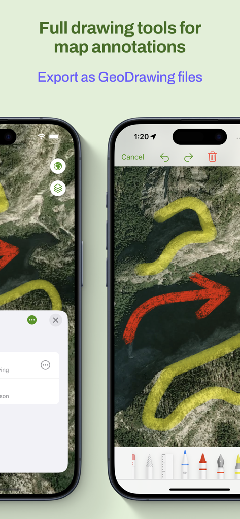
スマートフォンの画面に、さまざまな色の描画ツールとエクスポートオプションを備えたマップアノテーションが表示されています。
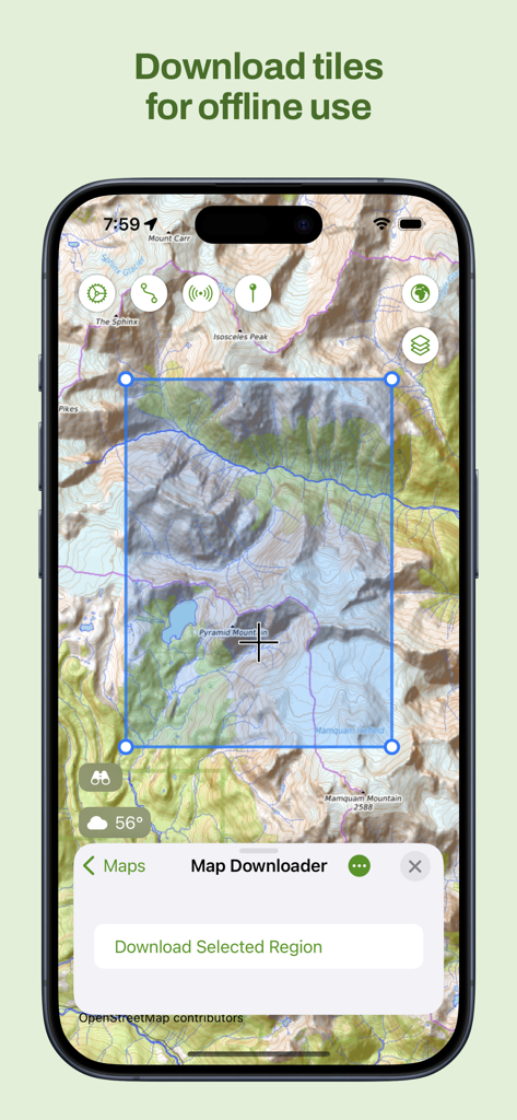
Maptrailsアプリのオフライン使用のための地形図タイルの選択とダウンロードのためのインターフェースを表示するiPhoneスクリーンショット。
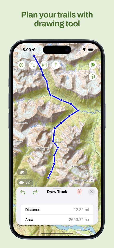
Maptrailsアプリの地形図と、トラック計画ツールを使用して描画されたカスタムハイキングパスを表示するiPhone画面。
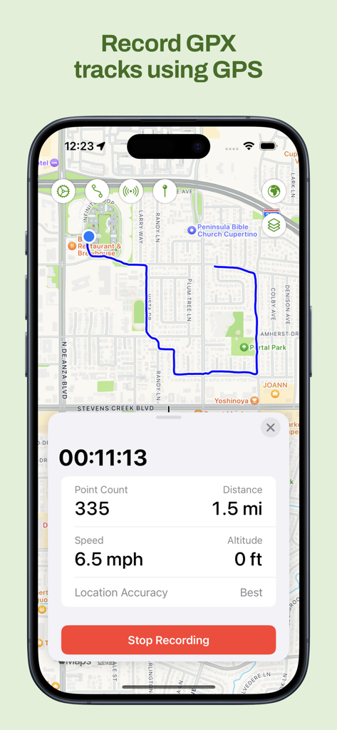
Maptrails iPhoneアプリが、リアルタイムの距離と速度データとともにマップ上でGPXトラックを記録しています。
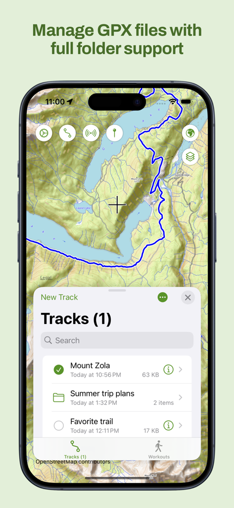
Maptrailsアプリのインターフェースで、地形図上のフォルダサポートによるGPXトラック管理を表示しています。
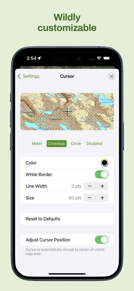
Maptrailsアプリのインターフェースで、地形図上の色やサイズなどの詳細なカーソルカスタマイズオプションを表示しています。
説明
Download
類似アプリ
似た機能とユーザー体験を持つアプリ

PredictWind — Marine Forecasts
PredictWind Limited

Navily
The Navigation Family

Argo - Boating Navigation
Argo Navigation, LLC

SEAiq Pilot
Sakhalin, LLC

KartenWerft NavGo 2.0
KartenWerft GmbH

MarineTraffic - Ship Tracking
MARINETRAFFIC APPLICATIONS LTD

Wavve Boating: Marine Boat GPS
Wavve Boating Inc

Savvy Navvy Boating Navigation
SAVVY NAVVY LTD

Aqua Map Boating
GEC s.r.l.
このページはアプリまたはその開発者の公式ページではなく、情報提供および論評を目的として作成された独立した編集出版物です。明示的に別段の記載がない限り、アプリおよびその開発者は、MWM、Apple、Google Play、アプリのパブリッシャー、またはアプリの開発者と提携、承認、後援、認可、またはその他の公式的な関係はなく、このページのいかなる内容も、アプリがMWMのサービスを使用して開発されたことを意味するものではありません。すべての商標、ロゴ、スクリーンショット、その他のコンテンツはそれぞれの所有者の財産です。