このページはアプリまたはその開発者の公式ページではなく、情報提供および論評を目的として作成された独立した編集出版物です。明示的に別段の記載がない限り、アプリおよびその開発者は、MWM、Apple、Google Play、アプリのパブリッシャー、またはアプリの開発者と提携、承認、後援、認可、またはその他の公式的な関係はなく、このページのいかなる内容も、アプリがMWMのサービスを使用して開発されたことを意味するものではありません。すべての商標、ロゴ、スクリーンショット、その他のコンテンツはそれぞれの所有者の財産です。

ダウンロード
7M+ユーザー評価
評価数
284K+開発元
カテゴリ
Travel対応言語
1最新バージョン
4.1.93サイズ
78.9 MBリリース日
2012年10月8日グローバルインテリジェンスで海をマスターする
リアルタイムの船舶位置情報からプロ仕様の海事データまで、MarineTrafficは精度と安心感をもってあなたの海事の旅を力づけます。
リアルタイム船舶インテリジェンス
ライブAISデータ、正確な港到着時間、プロ仕様のロジスティクス向け自動フリート管理により、毎日30万隻以上の船舶を追跡します。
インスタントAR識別
カメラを地平線にかざして、拡張現実(AR)を使用して船舶、港、灯台を即座に識別し、好奇心を満たしましょう。
よくある質問
について知っておくべきこと MarineTraffic - Ship Tracking
MarineTraffic - Ship Trackingとは何ですか?
MarineTraffic - Ship Trackingは、世界中の船舶やヨットのほぼリアルタイムな位置を表示するアプリです。船舶追跡のために、ほとんどの主要港と航路をカバーする、陸上ベースのAIS受信機による最大のネットワークを使用しています。
MarineTraffic - Ship Trackingはリアルタイムの船舶追跡を提供しますか?
はい、MarineTraffic - Ship Trackingはほぼリアルタイムの船舶追跡を提供します。30万隻以上の船舶がMarineTraffic AISネットワーク経由で毎日位置情報を報告しており、ユーザーは地図上でライブ表示できます。
MarineTraffic - Ship Trackingアプリで気象予報を表示できますか?
はい、MarineTraffic - Ship Trackingは、地図上で直接、現在の風況と48時間の風予報を提供します。追加のWeather Maps Layersサブスクリプションでは、包括的なリアルタイムおよび予報の気象情報が提供されます。
MarineTrafficの拡張現実(AR)ツールはどのように機能しますか?
MarineTrafficアプリには拡張現実ツールが搭載されています。ユーザーはデバイスのカメラを水平線にかざすことで、船舶、港、灯台を識別し、名前、旗、速度、距離などの詳細情報を即座に入手できます。
MarineTraffic - Ship Trackingで利用可能なサブスクリプションオプションは何ですか?
MarineTraffic - Ship Trackingは、Starter Plan、Nautical Charts、Weather Maps Layers、Advanced Density Mapsのいくつかの自動更新サブスクリプションを提供しています。これらは月払いと年払いの両方のオプションで利用できます。
MarineTraffic - Ship TrackingのStarter Planの料金はいくらですか?
MarineTraffic - Ship TrackingのStarter Plan Annualサブスクリプションは9.99ドル(USD)です。毎年更新され、詳細な船舶および港の情報、船舶の航跡、拡張現実などの広範な機能が利用可能になります。
MarineTraffic - Ship Trackingは港の入出港情報を提供できますか?
はい、MarineTraffic - Ship Trackingは、4,000以上の港とマリーナのライブ入出港情報を提供します。また、現在の港の状況と船舶の到着予定時刻(ETA)も表示します。
MarineTraffic - Ship Trackingは、陸上ベースのAIS以外の船舶を追跡する方法を提供していますか?
はい、MarineTraffic - Ship Trackingは、陸上ベースのAISステーションの範囲外にある船舶の衛星追跡を提供します。この機能は、ACCESS PLUS 24というアプリ内購入を通じて利用できます。
MarineTrafficアプリのサブスクリプションを管理するにはどうすればよいですか?
ユーザーは、購入後にアカウント設定にアクセスすることで、MarineTrafficサブスクリプションを管理し、自動更新をオフにすることができます。支払いは、リンクされたiTunesアカウントに直接請求されます。
MarineTraffic - Ship Trackingは、ユーザーがルートを計画することを許可していますか?
はい、MarineTraffic - Ship TrackingにはROUTE PLANNERツールが含まれています。ユーザーは地図上で直接ルートを計画し、距離を正確に測定し、到着予定時刻(ETA)を計算できます。
MarineTrafficのNautical Chartsにはどのような情報が含まれていますか?
MarineTrafficのNautical Chartsには、航路情報、海底の詳細、航路標識、ランドマークが含まれています。また、バース、ドック、ブイ、灯、灯台の位置などの港の詳細も記載されています。
MarineTrafficで船舶や港の通知を受け取ることはできますか?
はい、MarineTraffic - Ship Trackingは、船舶や港のプッシュ通知をサポートしています。ユーザーは、AISの目的地変更や新しい写真のアップロードなど、さまざまなイベントのアラートをカスタマイズできます。
以下のスクリーンショットと説明は、アプリの公式ストアリスティングから直接取得されたものであり、アプリ開発者の所有物です。
アプリストア
スクリーンショット
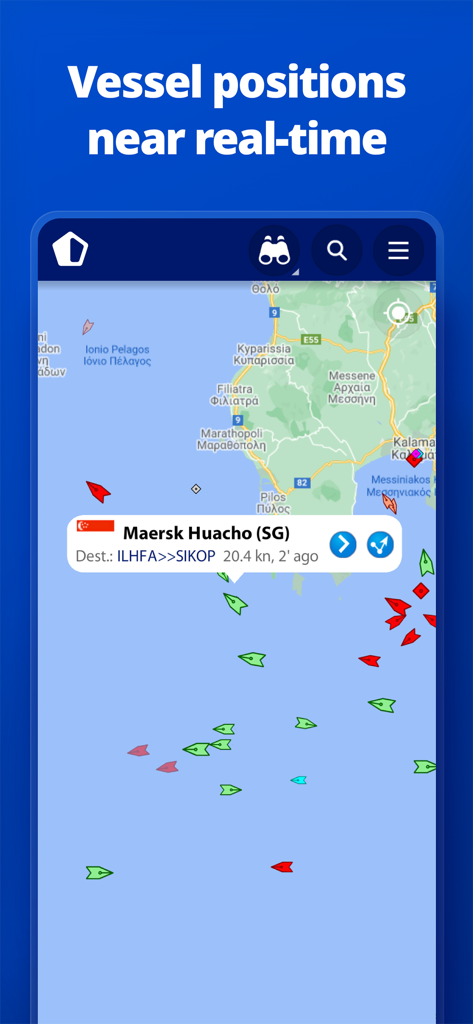
MarineTrafficアプリのインターフェース。ライブマップ上でリアルタイムの船舶位置と船舶詳細を表示
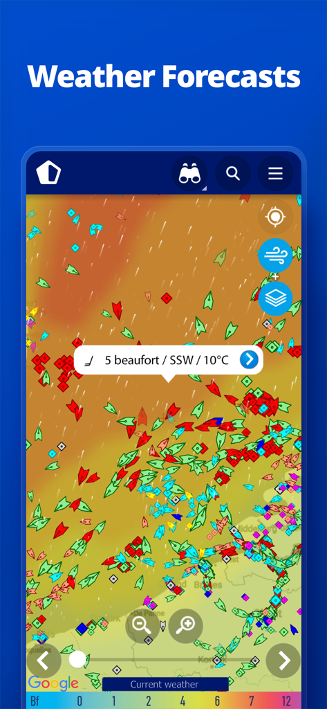
MarineTrafficアプリの表示。風と温度データを含む船舶位置とリアルタイムの海洋気象予報を表示
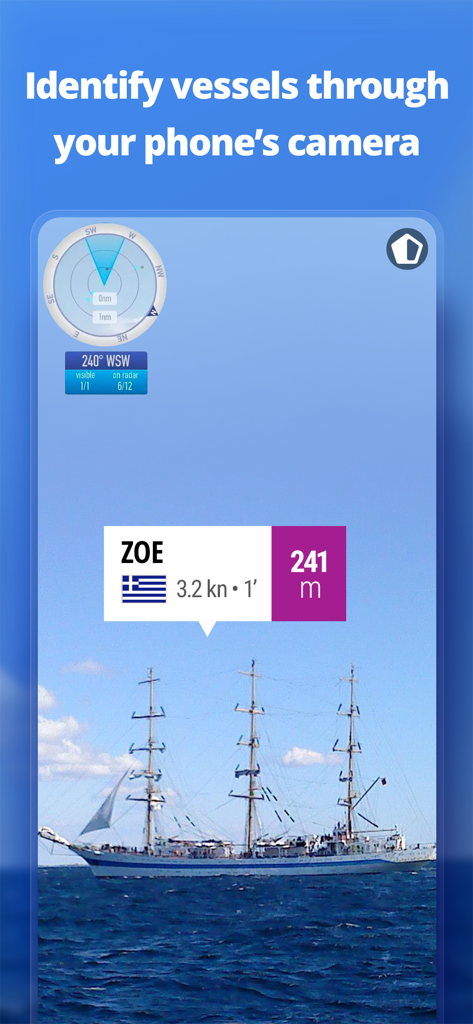
MarineTrafficアプリの拡張現実機能。携帯電話のカメラを通して船舶を識別
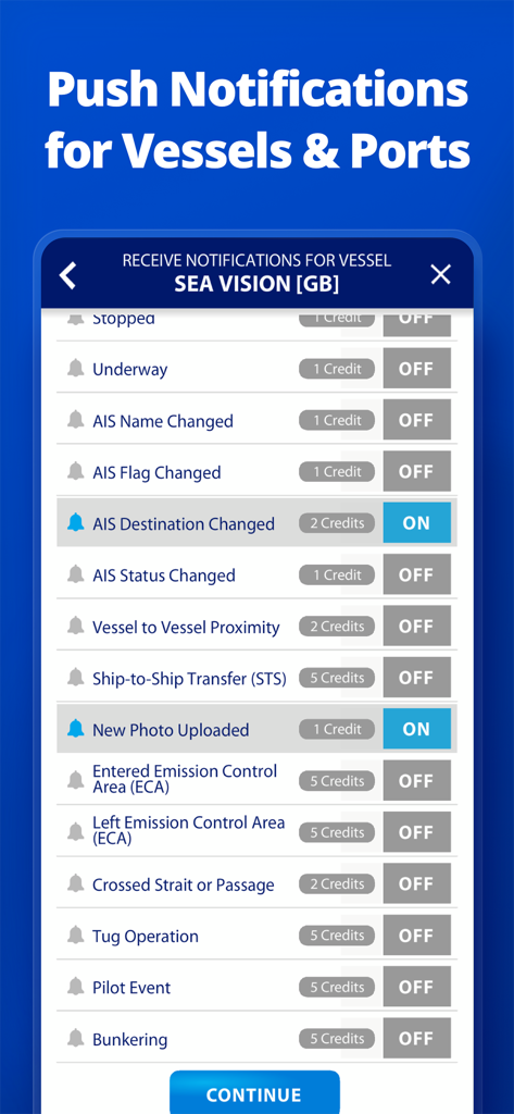
MarineTrafficアプリのインターフェース。AISの変更や写真のアップロードを含む船舶のカスタム通知設定を表示
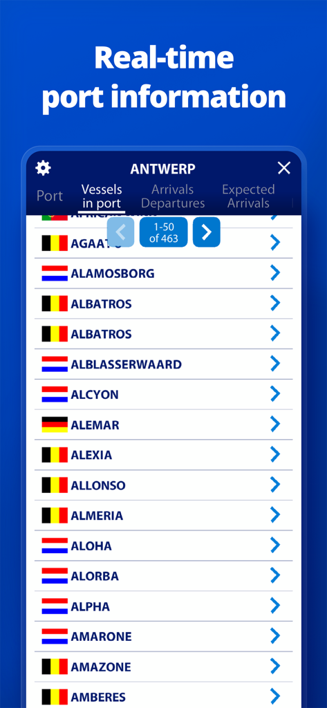
MarineTrafficアプリのスクリーンショット。アントワープ港の現在の船舶リストを表示
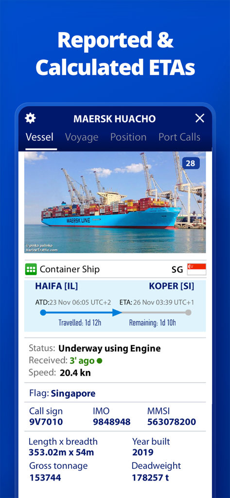
MarineTrafficアプリのインターフェース。コンテナ船の詳細な船舶情報と推定到着時間を表示
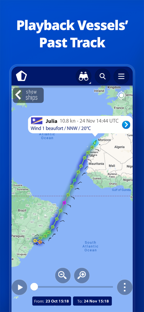
マップ上で大西洋を横断する船舶ルートの履歴再生を表示するインターフェース
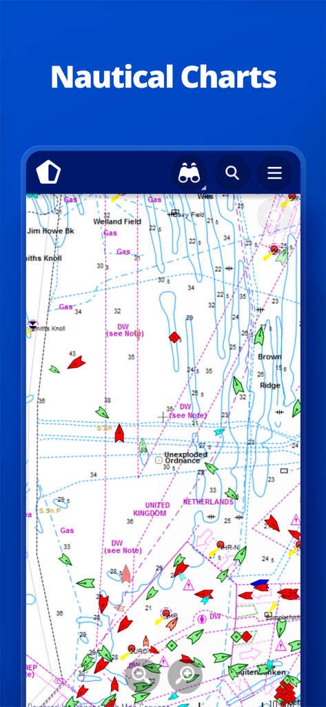
MarineTrafficアプリのインターフェース。リアルタイムの船舶追跡とナビゲーションシンボルを備えた詳細な海図を表示
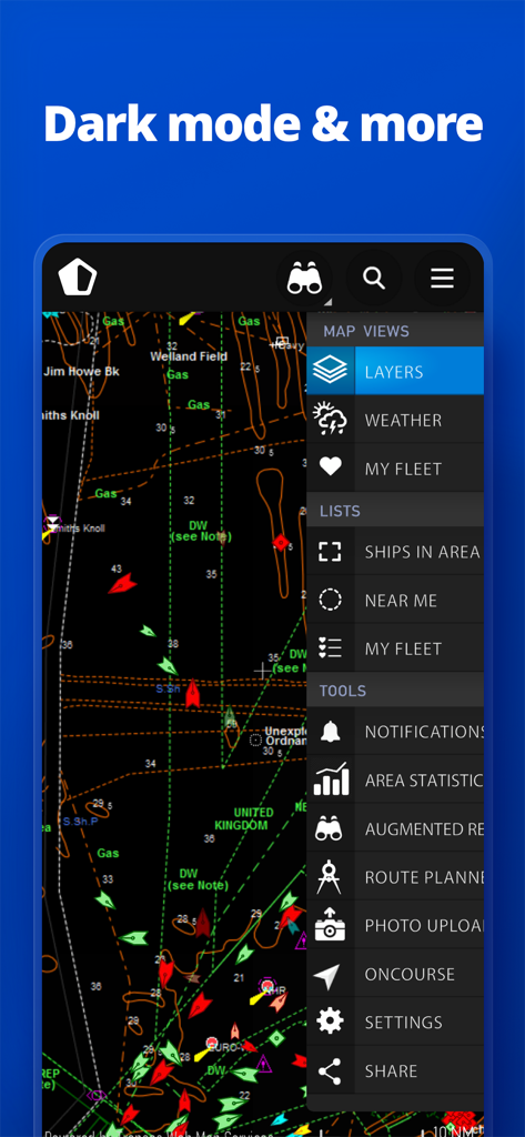
MarineTrafficアプリのインターフェース。船舶アイコンと、天気やルートプランナーなどの機能のサイドメニューを備えたダークモードの海図を表示
説明
Download
類似アプリ
似た機能とユーザー体験を持つアプリ

PredictWind — Marine Forecasts
PredictWind Limited

Navily
The Navigation Family

Argo - Boating Navigation
Argo Navigation, LLC

SEAiq Pilot
Sakhalin, LLC

Maptrails
Pasi Salenius

KartenWerft NavGo 2.0
KartenWerft GmbH

Wavve Boating: Marine Boat GPS
Wavve Boating Inc

Savvy Navvy Boating Navigation
SAVVY NAVVY LTD

Aqua Map Boating
GEC s.r.l.
このページはアプリまたはその開発者の公式ページではなく、情報提供および論評を目的として作成された独立した編集出版物です。明示的に別段の記載がない限り、アプリおよびその開発者は、MWM、Apple、Google Play、アプリのパブリッシャー、またはアプリの開発者と提携、承認、後援、認可、またはその他の公式的な関係はなく、このページのいかなる内容も、アプリがMWMのサービスを使用して開発されたことを意味するものではありません。すべての商標、ロゴ、スクリーンショット、その他のコンテンツはそれぞれの所有者の財産です。