このページはアプリまたはその開発者の公式ページではなく、情報提供および論評を目的として作成された独立した編集出版物です。明示的に別段の記載がない限り、アプリおよびその開発者は、MWM、Apple、Google Play、アプリのパブリッシャー、またはアプリの開発者と提携、承認、後援、認可、またはその他の公式的な関係はなく、このページのいかなる内容も、アプリがMWMのサービスを使用して開発されたことを意味するものではありません。すべての商標、ロゴ、スクリーンショット、その他のコンテンツはそれぞれの所有者の財産です。

Wavve Boating: Marine Boat GPS
複雑なチャートプロッターでの操作はもうやめましょう。ボートの喫水に合わせたカスタム海図、リアルタイムの天気、友達のライブ追跡がすべて1つの使いやすいアプリで利用できます。
ダウンロード
866K+ユーザー評価
評価数
5K+開発元
カテゴリ
Navigation対応言語
1最新バージョン
5.5.9サイズ
181.6 MBリリース日
2017年8月12日すべてのキャプテンのためにボートをシンプルに
複雑なチャートは忘れてください。Wavveは、直感的なナビゲーション、リアルタイムの安全データ、ソーシャル接続を組み合わせて、水上での毎日をストレスフリーにします。
パーソナライズされた安全マップ
ボートの喫水深を設定すれば、Wavveが安全な航行エリアを表示します。「青いエリア」にとどまり、「赤いエリア」を避けることで、高額なプロペラ損傷を防ぎましょう。
リアルタイムの海洋天気予報
7日間の予報と潮汐予測で、天候に合わせて計画を立てましょう。ドックを出る前に波の高さと風速を知ることができます。
よくある質問
について知っておくべきこと Wavve Boating: Marine Boat GPS
Wavve Boating: Marine Boat GPS とは何ですか?
Wavve Boating: Marine Boat GPS は、ボーター向けのナビゲーションアプリです。詳細な海図、潮汐予報、天気予報を、船舶ナビゲーションのための使いやすいツールにまとめて提供します。
Wavve Boating: Marine Boat GPS のサブスクリプション料金はいくらですか?
Wavve Boating: Marine Boat GPS のサブスクリプションは、月額オプションで月額 11.99 ドル、年額オプションで年間 59.99 ドルです。14日間の無料トライアルも利用可能です。
Wavve Boating: Marine Boat GPS には無料トライアルがありますか?
はい、Wavve Boating: Marine Boat GPS には 14 日間の無料トライアル期間があります。ユーザーはアプリを無料でダウンロードして、サブスクライブする前にその機能にアクセスできます。
Wavve Boating: Marine Boat GPS の海図はどの地域をカバーしていますか?
Wavve Boating: Marine Boat GPS は、米国、カナダ、オーストラリア、英国の海図を提供しています。ユーザーは Wavve Boating のウェブサイトで全域の地図を表示できます。
Wavve Boating: Marine Boat GPS は海図のカスタマイズを許可していますか?
はい、Wavve Boating: Marine Boat GPS は海図のカスタマイズを許可しています。ユーザーは自身の船の喫水を設定でき、アプリは特定の船に合わせて海図を再描画します。
Wavve Boating: Marine Boat GPS は潮汐予報を提供していますか?
はい、Wavve Boating: Marine Boat GPS は潮汐予報を提供しています。水位の変化を追跡し、北米地域では最大 18 時間先の予測水位を表示します。
Wavve Boating: Marine Boat GPS には天気予報が含まれていますか?
はい、Wavve Boating: Marine Boat GPS には包括的な天気予報が含まれています。北米向けに 7 日間の予報を提供し、気温、風速、波高を表示します。
Wavve Boating: Marine Boat GPS で友人と現在地を共有できますか?
はい、ユーザーは「Fleets of Friends」機能を使用して Wavve Boating: Marine Boat GPS で友人と現在地を共有できます。ユーザーは自分の位置を非表示にすることも選択できます。
Wavve Boating: Marine Boat GPS はボーターが危険を回避するのに役立ちますか?
はい、Wavve Boating: Marine Boat GPS はボーターが危険を回避するのに役立ちます。色分けされたエリアなど、明確な視覚情報を提供し、水上での潜在的な危険を強調します。
Wavve Boating: Marine Boat GPS はオフラインで使用できますか?
はい、Wavve Boating: Marine Boat GPS はオフラインで使用できます。ユーザーは、インターネット接続がない状態でもナビゲーションを継続できるように、海図データをダウンロードできます。
Wavve Boating: Marine Boat GPS で興味のある地点をマークして共有できますか?
はい、ユーザーは Wavve Boating: Marine Boat GPS で興味のある地点をマークできます。共有またはプライベートなピンを地図に追加でき、共有ピンにはコミュニティ投票が可能です。
Wavve Boating: Marine Boat GPS はどのような他のマリン GPS アプリの代わりになりますか?
Wavve Boating: Marine Boat GPS は、従来のチャートプロッターや、Navionics、Embark、Garmin Active Captain などのアプリケーションの代替となり、海図を統合しています。
Wavve Boating: Marine Boat GPS は自動ルーティング機能を備えていますか?
はい、Wavve Boating: Marine Boat GPS は自動ルーティング機能を備えています。この機能は、効率的な船舶ナビゲーションのために設計された包括的なツールスイートの一部です。
以下のスクリーンショットと説明は、アプリの公式ストアリスティングから直接取得されたものであり、アプリ開発者の所有物です。
アプリストア
スクリーンショット
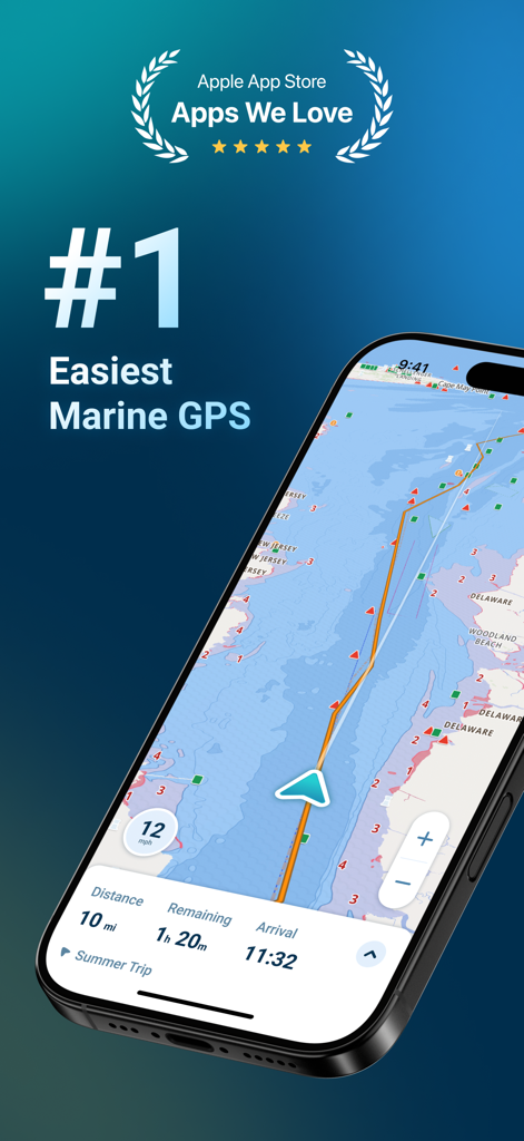
海図と航海詳細が表示されたWavve BoatingマリンGPSナビゲーションインターフェースを表示するスマートフォン
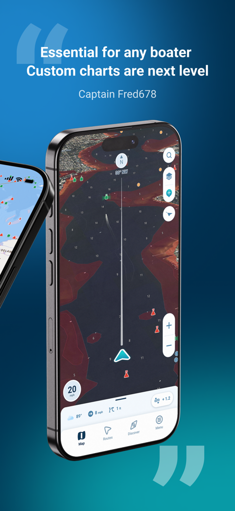
Wavve Boating海図と肯定的なユーザーレビューを表示するスマートフォンの画面
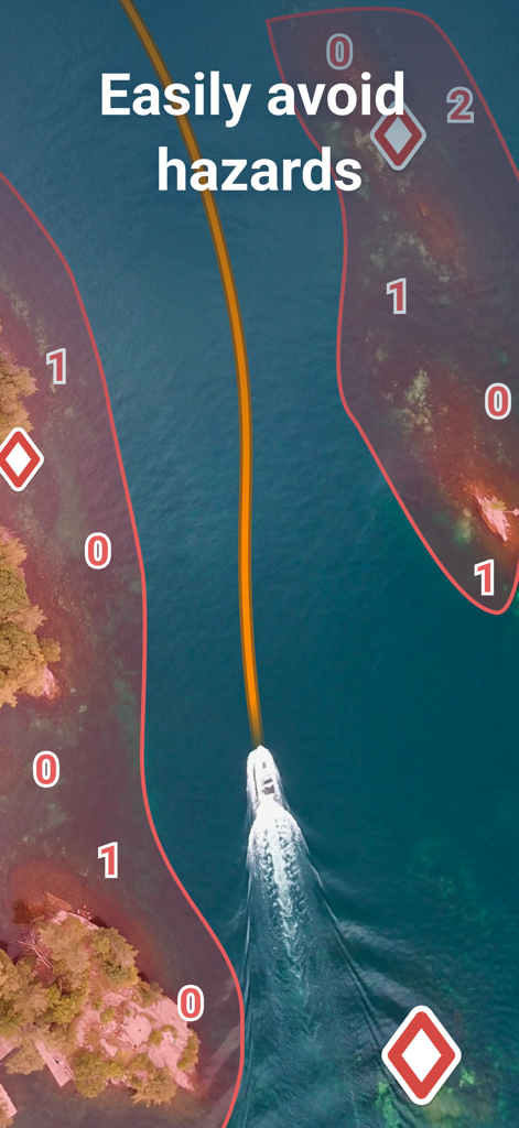
Wavve BoatingマリンGPSアプリの赤い危険ゾーン間の安全な青い経路を航行するボート
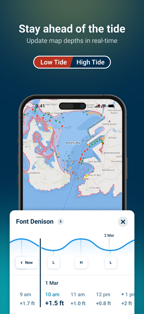
Wavve Boatingアプリがリアルタイムの潮汐予測と深度更新をマリンGPSチャートに表示
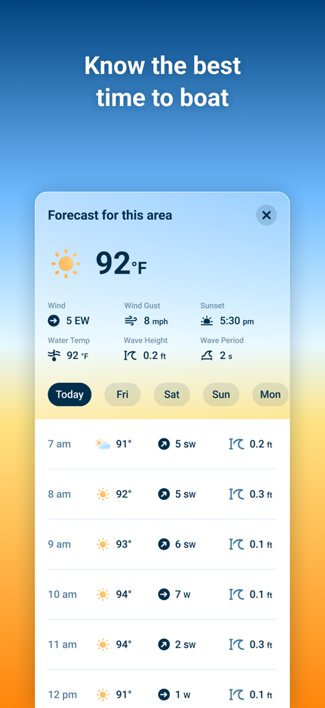
Wavve Boatingアプリのモバイルインターフェースに風速と波の高さを含む海洋天気予報が表示される
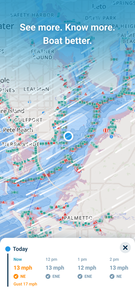
Wavve Boatingアプリインターフェースに、リアルタイムの風速と天気予報パネルを備えた海洋ナビゲーションマップが表示される
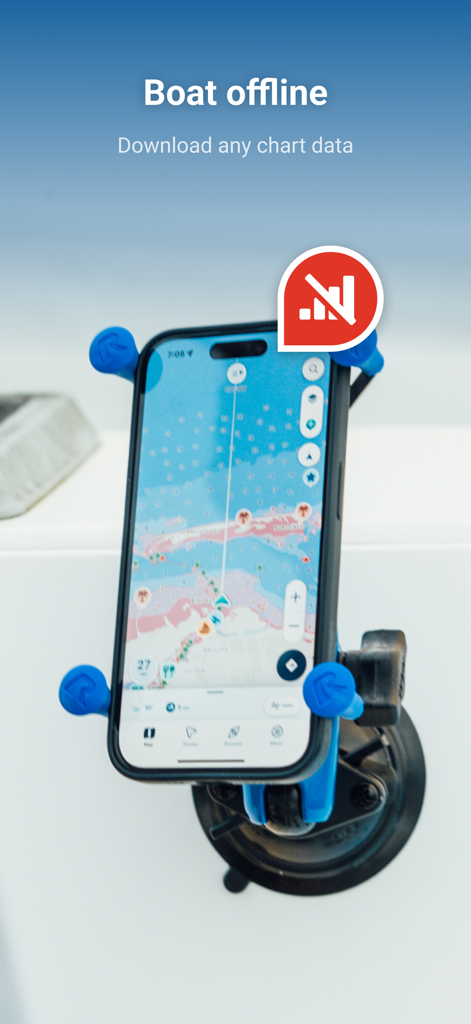
オフライン海図を表示するWavve Boatingアプリが搭載されたボートに取り付けられたiPhone
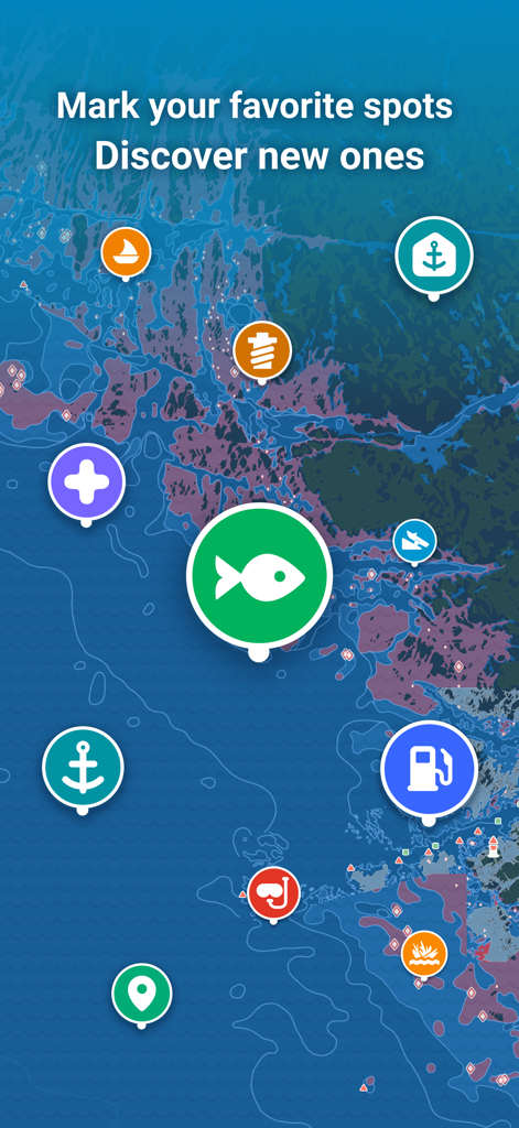
釣り、燃料、係留地のカラフルなアイコンが付いた海図
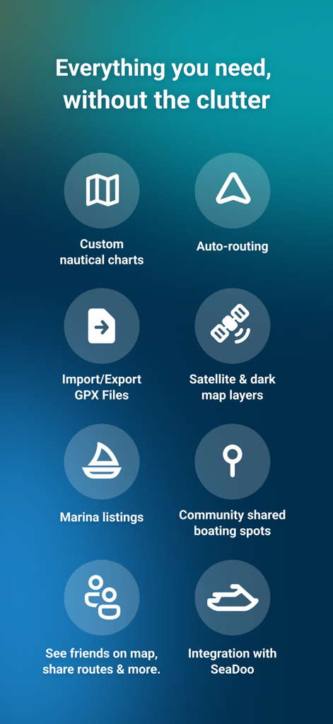
カスタム海図、自動ルーティング、ソーシャルナビゲーションツールを含むWavve Boatingアプリの機能リスト
説明
Download
類似アプリ
似た機能とユーザー体験を持つアプリ

PredictWind — Marine Forecasts
PredictWind Limited

Navily
The Navigation Family

Argo - Boating Navigation
Argo Navigation, LLC

SEAiq Pilot
Sakhalin, LLC

Maptrails
Pasi Salenius

KartenWerft NavGo 2.0
KartenWerft GmbH

MarineTraffic - Ship Tracking
MARINETRAFFIC APPLICATIONS LTD

Savvy Navvy Boating Navigation
SAVVY NAVVY LTD

Aqua Map Boating
GEC s.r.l.
このページはアプリまたはその開発者の公式ページではなく、情報提供および論評を目的として作成された独立した編集出版物です。明示的に別段の記載がない限り、アプリおよびその開発者は、MWM、Apple、Google Play、アプリのパブリッシャー、またはアプリの開発者と提携、承認、後援、認可、またはその他の公式的な関係はなく、このページのいかなる内容も、アプリがMWMのサービスを使用して開発されたことを意味するものではありません。すべての商標、ロゴ、スクリーンショット、その他のコンテンツはそれぞれの所有者の財産です。