このページはアプリまたはその開発者の公式ページではなく、情報提供および論評を目的として作成された独立した編集出版物です。明示的に別段の記載がない限り、アプリおよびその開発者は、MWM、Apple、Google Play、アプリのパブリッシャー、またはアプリの開発者と提携、承認、後援、認可、またはその他の公式的な関係はなく、このページのいかなる内容も、アプリがMWMのサービスを使用して開発されたことを意味するものではありません。すべての商標、ロゴ、スクリーンショット、その他のコンテンツはそれぞれの所有者の財産です。

TroutRoutes: Fly Fishing App
次の釣行を、計算された冒険に変えましょう。50,000以上のマッピングされた河川、確実な公有地の境界線、リアルタイムの水流データにアクセスし、絶対的な自信を持って釣りを楽しめます。
ダウンロード
726K+ユーザー評価
評価数
3K+開発元
カテゴリ
Navigation対応言語
1最新バージョン
5.3.5サイズ
282.9 MBリリース日
2019年3月4日すべてのアングラーのための究極の戦術的優位性
精度、合法的なアクセス、リアルタイムの河川インサイトのために構築された業界をリードするマッピングツールで、スカウティングの時間を減らし、キャストの時間を増やしましょう。
公有地アクセスをマスターする
私有地との境界線を色分けした公有地と私有地の境界線で、小道や私有地への侵入を避け、完全な安心感を持って釣りを楽しめます。
リアルタイム河川インテリジェンス
USGSのライブ水流データと水温チャートで、行く前に確認しましょう。選択した目的地が最高の釣りコンディションであることを保証します。
よくある質問
について知っておくべきこと TroutRoutes: Fly Fishing App
onXのTroutRoutesとは何ですか?
onXのTroutRoutesは、マス釣り用のGPSマッピングツールとしてはNo.1であり、米国本土の50,000以上のマス釣り用河川に関するインタラクティブマップ、河川データ、ナビゲーションを提供します。
TroutRoutesは釣り場を見つけるのに役立ちますか?
はい、TroutRoutesは、トレイルアクセス、駐車場、公共アクセスポイントなどの詳細を表示する独自の маппинг システムにより、ユーザーが地元の釣り場を見つけ、新しい水域を探索するのに役立ちます。
TroutRoutesではいくつものマス釣り用河川がマッピングされていますか?
TroutRoutesは、米国本土の48州にわたる50,000以上のマス釣り用河川をマッピングしています。生息地の質を含む、各河川と川に関する包括的な情報を提供します。
TroutRoutesはオフラインで使用できますか?
はい、TroutRoutesでは、ユーザーは河川または地域ごとに詳細なマップをダウンロードしてオフラインで使用できます。この機能により、携帯サービスの圏外でも機能が保証され、ユーザーはカスタムマークアップを保存できます。
TroutRoutesはリアルタイムの河川状況を表示しますか?
はい、TroutRoutesはリアルタイムの河川状況を提供します。河川ゲージからのライブデータを使用して、流量、河川の水位、水温を表示し、情報に基づいた釣りの決定を支援します。
TroutRoutes PROメンバーシップの料金はいくらですか?
TroutRoutes PROメンバーシップの料金は年間58.99ドルです。このプランには、48州全域のすべての機能、50,000の分類されたマス釣り用河川、280,000のカスタムアクセスポイントへのアクセスが含まれます。
TroutRoutesには無料トライアルがありますか?
はい、TroutRoutesは、アプリのインストール時に7日間の無料PROトライアルを提供しています。このトライアルでは、公有地、分類されたマス釣り用河川、カスタムアクセスポイント、オフラインマップへのアクセスが有効になります。
TroutRoutesでフライフィッシングショップへの道順を教えてもらえますか?
はい、TroutRoutesは、ユーザーが地元のフライフィッシングショップを見つけるのに役立ちます。このアプリは、ショップの場所、ウェブサイトへの直接アクセス、および利便性のためのナビゲーションルートを提供します。
TroutRoutesは漁業規制に関する情報を提供しますか?
はい、TroutRoutesには規制マップが含まれており、各州の漁業規制区分が色分けされています。詳細な河川規制を提供し、コンプライアンスを確保します。
TroutRoutesはどのような種類のアクセスポイントを特定しますか?
TroutRoutesは、漁業権益、国立公園、地方公園、ボートランプなど、さまざまなアクセスポイントを特定します。280,000以上の手作業でキュレーションされた公共アクセスポイントを特徴としています。
TroutRoutesでカスタムの興味のある地点をマークできますか?
はい、TroutRoutesでは、ユーザーはカスタムマップを作成できます。ユーザーは、プライベートマークアップやメモを興味のある地点に追加でき、旅行の計画と追跡を強化できます。
TroutRoutesは単一州のメンバーシップを提供していますか?
はい、TroutRoutesは年間19.99ドルで単一州メンバーシップを提供しています。このプランでは、選択した州の分類されたマス釣り用河川やカスタムアクセスポイントなどのすべてのPRO機能にアクセスできます。
以下のスクリーンショットと説明は、アプリの公式ストアリスティングから直接取得されたものであり、アプリ開発者の所有物です。
アプリストア
スクリーンショット
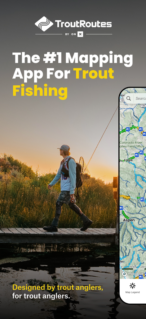
夕暮れ時に橋を渡るフライフィッシャーマンと、TroutRoutesフィッシングマップアプリを表示するスマートフォン
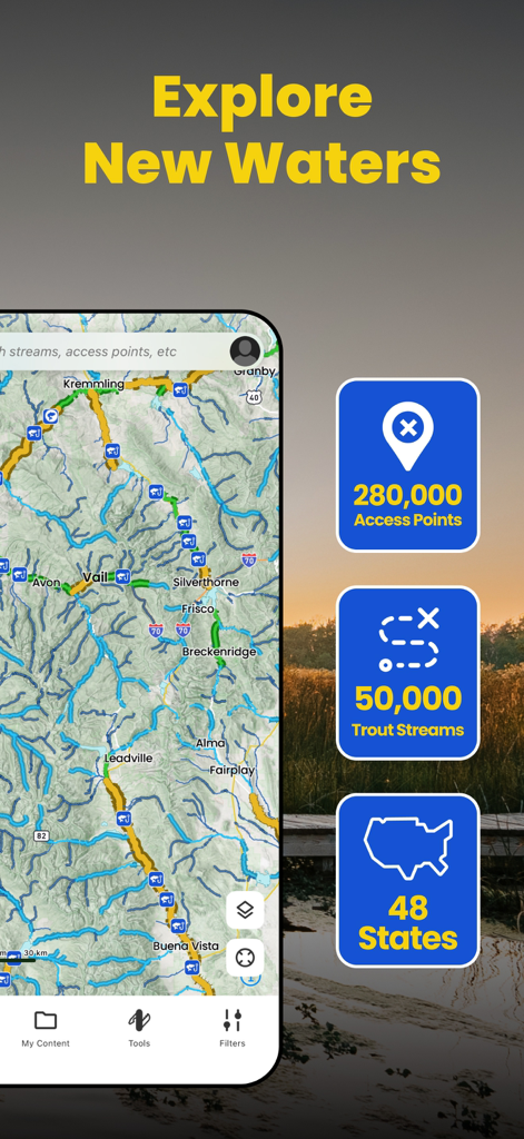
マス釣り用河川とアクセスポイントの地図を表示するTroutRoutesアプリのインターフェース
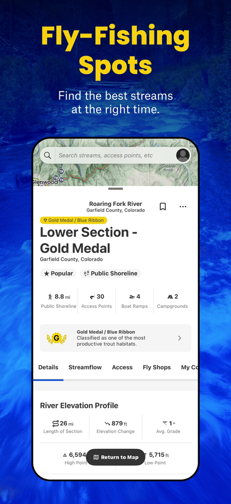
コロラド州のRoaring Fork Riverの詳細と釣りスポットを表示するTroutRoutesアプリのインターフェース
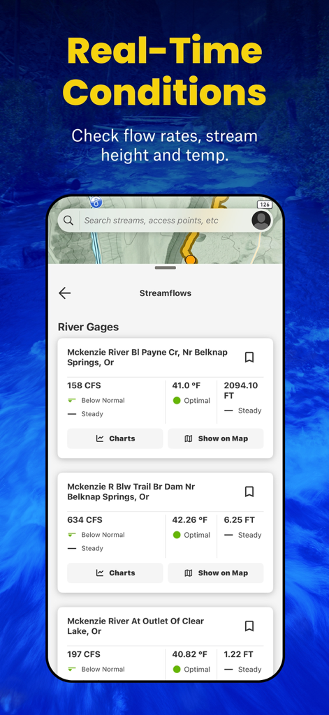
水流率、水温、水位を含むリアルタイムの河川状況を表示するTroutRoutesアプリのインターフェース
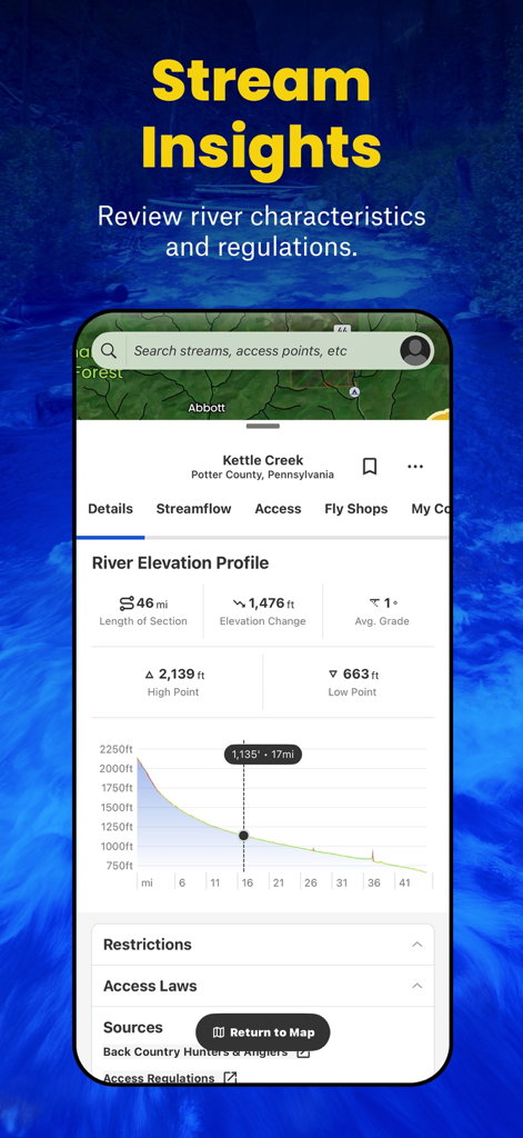
フライフィッシング計画のための河川標高プロファイルと河川特性を表示するTroutRoutesアプリのディスプレイ
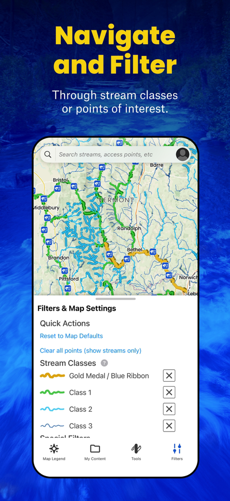
バーモント州のマス釣り用河川の地形図と河川クラスフィルターを表示するTroutRoutesアプリのインターフェース
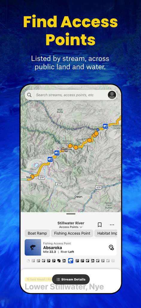
Stillwater Riverの釣りアクセスポイントと河川データが表示された地図を表示するTroutRoutesアプリのスクリーンショット
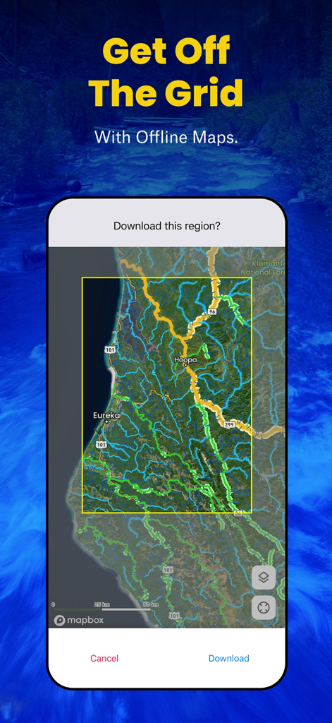
マス釣り用河川のオフラインマップをダウンロードするためのTroutRoutesアプリのインターフェースを表示するスマートフォンの画面

カスタムマップウェイポイントと釣りスポットを設定するためのTroutRoutesアプリのインターフェース
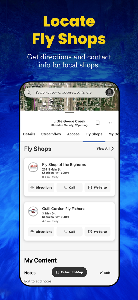
連絡先情報と道順付きの地元のフライショップを表示するTroutRoutesアプリのインターフェース
説明
Download
類似アプリ
似た機能とユーザー体験を持つアプリ

FishAngler - Fish Finder App
FishAngler, LLC

钓鱼天气预报
Hefei Sasha Technology Co., Ltd.

潮汐表-潮汐天气预报&钓鱼潮汐天气工具助手
荣虎 太

Fishbrain - Fishing App
FishBrain AB

Fishing Points: Map & Forecast
Fishing Points d.o.o.

onX Fish: Midwest Lake Finder
onXmaps, Inc.

Fishbox - Smart Fishing App
MEMS Group, Inc.

釣果記録FishRanker-フィッシュランカー,釣り,分析
SIIG Inc.

Fish Deeper - Fishing App
Deeper UAB
このページはアプリまたはその開発者の公式ページではなく、情報提供および論評を目的として作成された独立した編集出版物です。明示的に別段の記載がない限り、アプリおよびその開発者は、MWM、Apple、Google Play、アプリのパブリッシャー、またはアプリの開発者と提携、承認、後援、認可、またはその他の公式的な関係はなく、このページのいかなる内容も、アプリがMWMのサービスを使用して開発されたことを意味するものではありません。すべての商標、ロゴ、スクリーンショット、その他のコンテンツはそれぞれの所有者の財産です。