このページはアプリまたはその開発者の公式ページではなく、情報提供および論評を目的として作成された独立した編集出版物です。明示的に別段の記載がない限り、アプリおよびその開発者は、MWM、Apple、Google Play、アプリのパブリッシャー、またはアプリの開発者と提携、承認、後援、認可、またはその他の公式的な関係はなく、このページのいかなる内容も、アプリがMWMのサービスを使用して開発されたことを意味するものではありません。すべての商標、ロゴ、スクリーンショット、その他のコンテンツはそれぞれの所有者の財産です。

ダウンロード
500k+ユーザー評価
評価数
463開発元
カテゴリ
Utilities対応言語
3最新バージョン
1.1.0サイズ
42.6 MBリリース日
2025年9月21日「专业指南针-GPS北斗定位海拔测量导航」の主要機能とユーザーへの影響
アプリケーション機能分析
高度と緯度経度表示
ユーザーは、現在地の正確な高度と緯度経度座標をリアルタイムで確認でき、地理情報を精密に把握することが可能です。これにより、アウトドア探検や旅行の記録がより専門的になります。
ウォーターマークカメラ
本アプリのカメラ機能を使用すると、撮影した写真に時間、場所、高度、緯度経度のウォーターマークを自動的に追加できます。これにより、旅行の素晴らしい瞬間を地理的な情報と共に記録し、共有することが可能です。
精密コンパス
このアプリには高精度な電子コンパスが内蔵されており、リアルタイムで正確な方向指示を提供します。山道や市街地を問わず、ユーザーは迷うことなく進むことができます。
リアルタイム天気予報
本ツールは現在地のリアルタイム天気情報を提供し、温度、湿度、風力などが含まれます。これにより、ユーザーはいつでも天候状況を把握し、外出計画を効果的に立てることが可能です。
よくある質問
について知っておくべきこと 专业指南针-GPS北斗定位海拔测量导航
What is 专业指南针-GPS北斗定位海拔测量导航?
专业指南针-GPS北斗定位海拔测量导航 is a versatile outdoor navigation and life assistant app. It features an accurate compass, real-time altitude/coordinates, a smart leveler, real-time weather, and a watermark camera.
Does 专业指南针-GPS北斗定位海拔测量导航 provide an accurate compass?
Yes, the 专业指南针 app integrates a high-precision electronic compass. It provides real-time direction, ensuring users always know their heading, whether in mountains or cities.
Can 专业指南针 display current altitude and coordinates?
Yes, the 专业指南针 app displays real-time altitude, longitude, and latitude coordinates. This feature allows users to precisely understand their geographical information during outdoor exploration and travel.
Does the 专业指南针 app include a level measurement tool?
Yes, the 专业指南针 app includes a smart leveler tool. It easily detects the horizontal state of surfaces, which is useful for home decorating and equipment installation tasks.
How does 专业指南针 help with weather information?
The 专业指南针 app provides current location weather details like temperature, humidity, and wind power. This real-time data helps users plan their outings and travels effectively.
Can I add location data to photos using 专业指南针?
Yes, the 专业指南针 app has a watermark camera feature. It automatically embeds time, location, altitude, and coordinates onto photos, documenting every travel moment with geographical context.
What are the benefits of a VIP membership in 专业指南针?
Subscribing to VIP membership in 专业指南针 unlocks all premium features and high-definition output capabilities. This enhances the app's functionality for a more advanced user experience.
How do I manage or cancel my 专业指南针 subscription?
To manage or cancel your 专业指南针 subscription, navigate to Apple's "Settings" → "iTunes Store & App Store" → "Apple ID" → "View Apple ID" → "Account Settings" → "Subscriptions".
Where can I find the privacy policy for 专业指南针?
The privacy policy for 专业指南针 is available via a direct link. Users can access comprehensive information regarding data handling and privacy practices at https://docs.qq.com/doc/DY1VRd2ZFaGx4eFFo.
以下のスクリーンショットと説明は、アプリの公式ストアリスティングから直接取得されたものであり、アプリ開発者の所有物です。
アプリストア
スクリーンショット
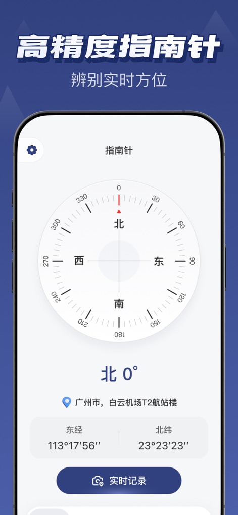
このアプリは高精度な電子コンパスを提供し、リアルタイムで正確な方位を示します。ユーザーは現在の経度と緯度の座標を確認でき、目的地の方角を迷うことなく把握できます。
高精度コンパス
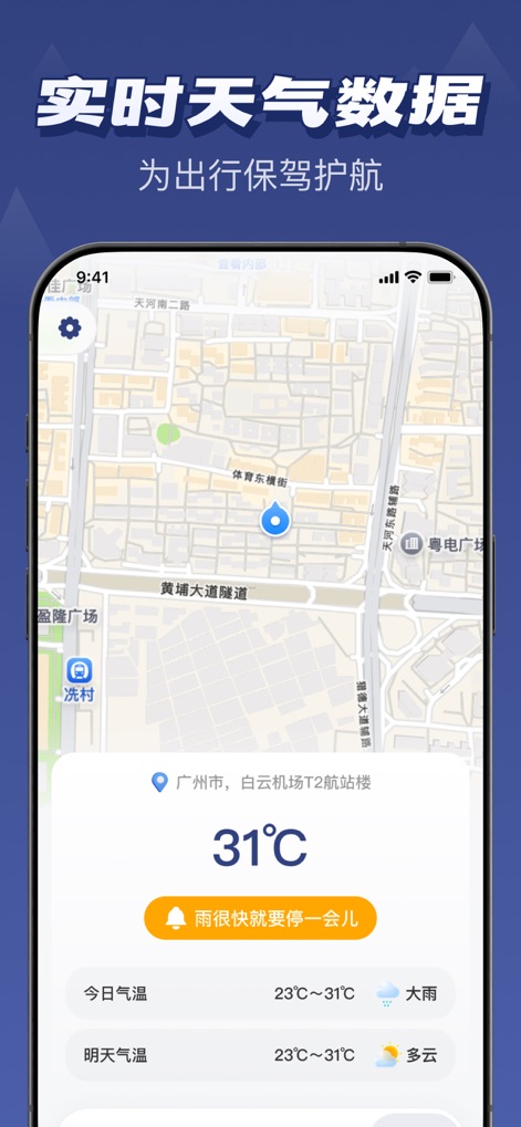
出かける前に、このアプリで現在の位置のリアルタイム気温 (31℃) を確認できます。さらに、今日の天気予報 (大雨から曇り) を詳細に把握し、最適な計画を立てられます。
リアルタイム天気
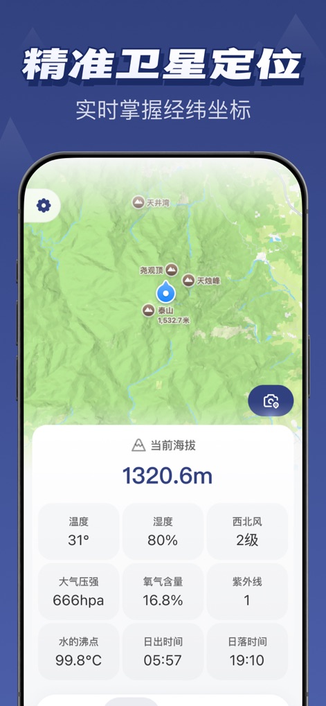
このツールは精密な衛星測位により、ユーザーの現在の標高 (1320.6m) を表示します。また、周囲の温度 (31℃) や湿度など、多様な環境データをリアルタイムで提供します。
精密な衛星測位
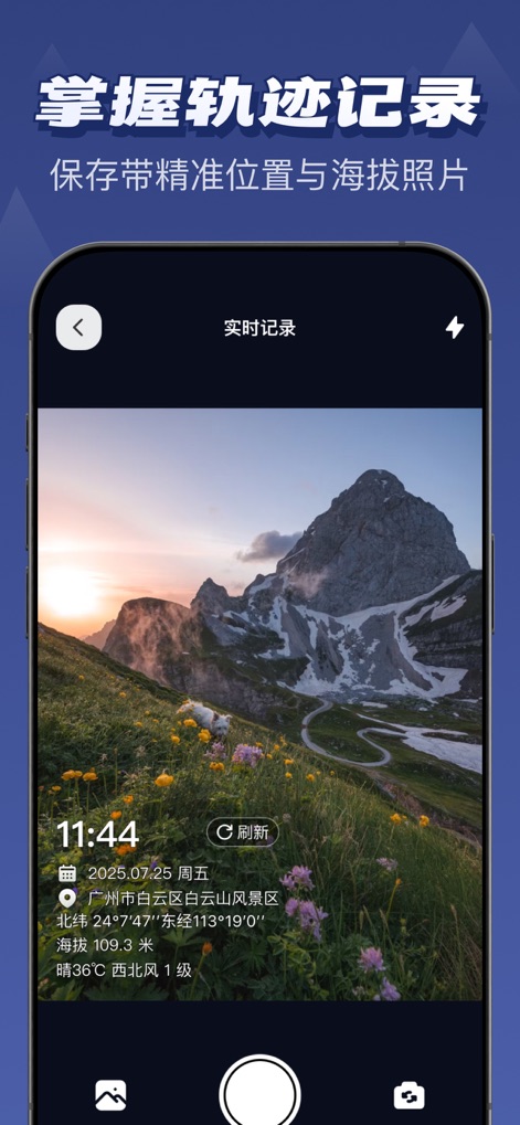
ユーザーはジオタグ付きカメラ機能で、美しい景色を撮影しながら、撮影日時 (2025年7月25日 11:44) や場所、標高、経緯度を自動的に写真に記録できます。
旅の記録を残す
説明
Download
類似アプリ
似た機能とユーザー体験を持つアプリ

Realtime Altimeter
Zhenlai Xia

Travel Camera & Compass
Ha Nguyen

compass-latitude and longitude
美霞 熊

Compass ×
DOUBLE U s.r.o.

GPS Altitude-海拔表
祥琦 孔

Compass: GPS & Altimeter
Shanghai BRC Internet Technology Co., Ltd.

Travel Altimeter & Elevation
BranchenKing Ltd.

Compass - GPS positioning
嘉 罗

Compass360X-GPS Speedometer
卫豪 吴
このページはアプリまたはその開発者の公式ページではなく、情報提供および論評を目的として作成された独立した編集出版物です。明示的に別段の記載がない限り、アプリおよびその開発者は、MWM、Apple、Google Play、アプリのパブリッシャー、またはアプリの開発者と提携、承認、後援、認可、またはその他の公式的な関係はなく、このページのいかなる内容も、アプリがMWMのサービスを使用して開発されたことを意味するものではありません。すべての商標、ロゴ、スクリーンショット、その他のコンテンツはそれぞれの所有者の財産です。