이 페이지는 앱이나 개발자의 공식 페이지가 아니며, 정보 제공 및 논평을 목적으로 작성된 독립 편집 간행물입니다. 명시적으로 달리 언급되지 않는 한, 해당 앱이나 개발자는 MWM, Apple, Google Play, 앱 퍼블리셔 또는 앱 개발자와 제휴, 보증, 후원, 승인 또는 공식적으로 연결되어 있지 않으며, 이 페이지의 어떤 내용도 해당 앱이 MWM의 서비스를 사용하여 개발되었음을 의미하지 않습니다. 모든 상표, 로고, 스크린샷 및 기타 콘텐츠는 해당 소유자의 자산입니다.

精图地球-高清,卫星,街景,全球,3D,探索
다양한 고정밀 영상, 과거 시점 복원 및 3D 지형 렌더링을 통합했습니다. KML/GeoJSON 데이터 그리기, 전문 GPS 궤적 기록 및 위도/경도 워터마크 카메라를 지원하여 몰입감 있는 지리 정보 전문 솔루션을 제공합니다.
다운로드
41K+사용자 평점
총 평가 수
200개발사
카테고리
Navigation지원 언어
1최신 버전
5.0.14크기
136.5 MB출시일
2023년 9월 12일Professional Mapping & Global Visualization
Empowering Chinese-speaking professionals and explorers with high-precision 3D terrain, historical satellite imagery, and enterprise-grade GIS tools.
전문 GIS 및 측량 도구
KML 또는 GeoJSON 데이터를 쉽게 그리고, 측정하고, 내보낼 수 있습니다. 부동산, 건설, 현장 측량에 이상적이며, 검증된 기록을 위한 GPS 워터마크 카메라가 내장되어 있습니다.
고화질 3D 지형
전 세계 풍경과 도시 경관의 초현실적인 3D 렌더링을 경험하세요. 지형 과장 및 과거 영상을 사용하여 시간에 따른 지형 변화를 분석할 수 있습니다.
다음 스크린샷과 설명은 앱의 공식 스토어 목록에서 직접 가져온 것이며 앱 개발자의 자산입니다.
앱 스토어
스크린샷
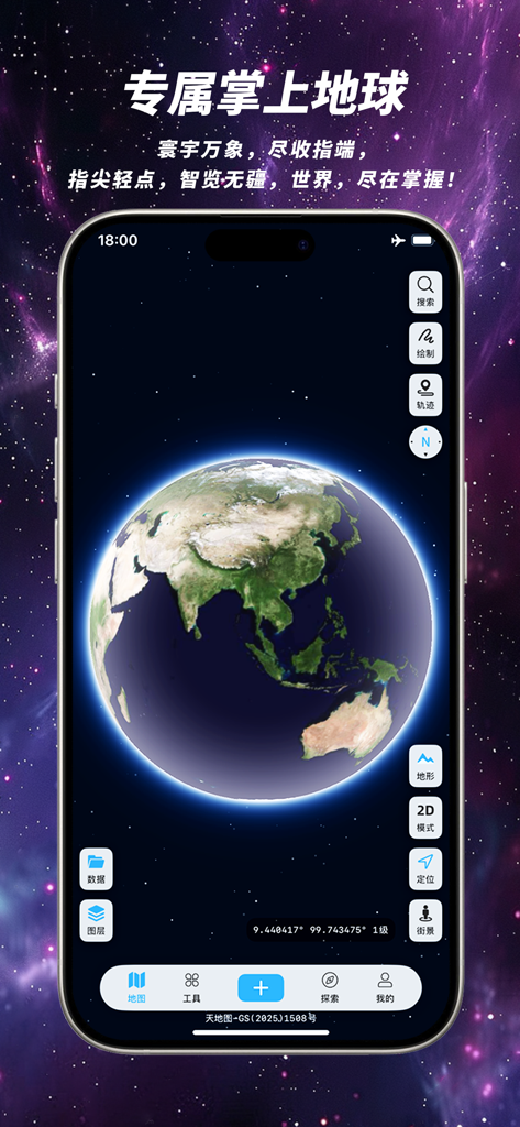
천체 배경을 배경으로 Kingtop Earth 앱 인터페이스 내의 고화질 3D 지구를 표시하는 스마트폰 화면
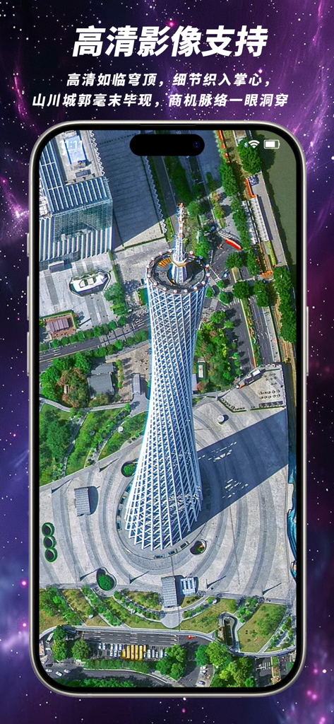
Kingtop Earth 모바일 앱 인터페이스 내에 표시된 광저우 캔턴 타워의 고화질 위성 뷰.
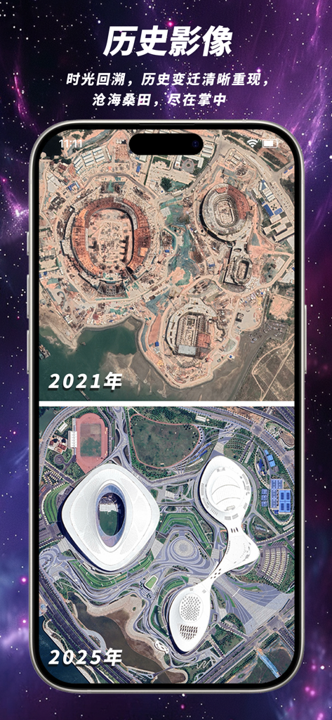
Kingtop Earth 앱에서 경기장 건설 및 완공을 보여주는 2021년과 2025년 위성 영상 비교
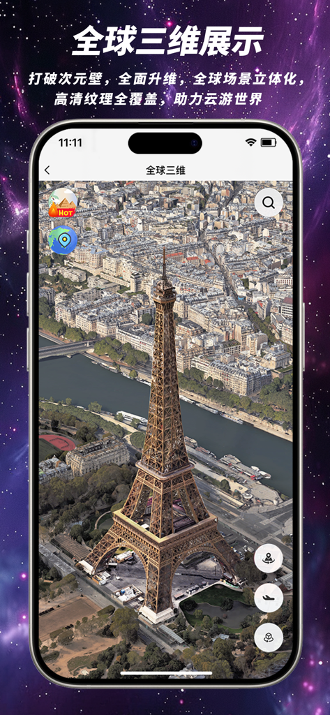
Kingtop Earth 앱 인터페이스에 표시된 파리 에펠탑의 고화질 3D 위성 뷰.
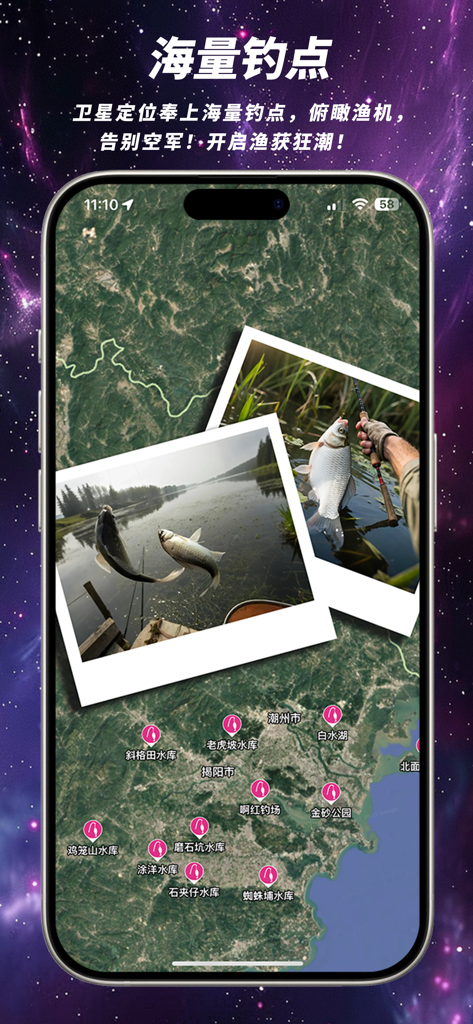
Kingtop Earth 내 위성 지도 뷰로, 다양한 낚시 장소 표시와 성공적인 조과 사진 표시
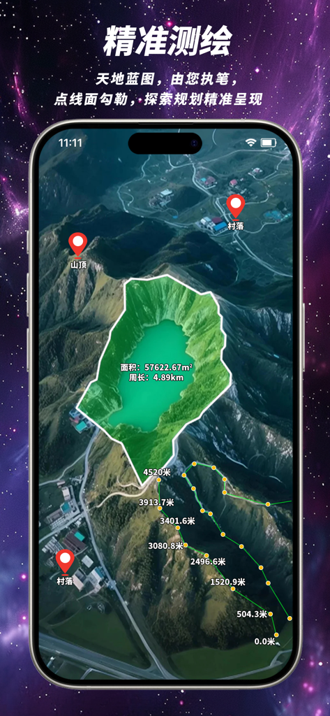
Kingtop Earth 앱 인터페이스에 영역 측정 및 거리 추적 도구가 있는 3D 위성 지도 표시
설명
Download
비슷한 앱
같은 카테고리의 상위 앱

Google Maps
Google LLC

Waze Navigation & Live Traffic
waze

AMap Global
AutoNavi Information Technology Co. Ltd.

百度地图-路线规划,出行必备
Beijing Baidu Netcom Science & Technology Co.,Ltd

Moovit: Bus & Transit Tracker
Moovit App Global LTD

Transit • Subway & Bus Times
9280-0366 Quebec inc.

ParkMobile: Park. Pay. Go.
Parkmobile USA, Inc

腾讯地图-路线规划,导航地铁打车出行
Shenzhen Tencent Computer Systems Company Limited

Île-de-France Mobilités
Ile de France Mobilites
이 페이지는 앱이나 개발자의 공식 페이지가 아니며, 정보 제공 및 논평을 목적으로 작성된 독립 편집 간행물입니다. 명시적으로 달리 언급되지 않는 한, 해당 앱이나 개발자는 MWM, Apple, Google Play, 앱 퍼블리셔 또는 앱 개발자와 제휴, 보증, 후원, 승인 또는 공식적으로 연결되어 있지 않으며, 이 페이지의 어떤 내용도 해당 앱이 MWM의 서비스를 사용하여 개발되었음을 의미하지 않습니다. 모든 상표, 로고, 스크린샷 및 기타 콘텐츠는 해당 소유자의 자산입니다.