이 페이지는 앱이나 개발자의 공식 페이지가 아니며, 정보 제공 및 논평을 목적으로 작성된 독립 편집 간행물입니다. 명시적으로 달리 언급되지 않는 한, 해당 앱이나 개발자는 MWM, Apple, Google Play, 앱 퍼블리셔 또는 앱 개발자와 제휴, 보증, 후원, 승인 또는 공식적으로 연결되어 있지 않으며, 이 페이지의 어떤 내용도 해당 앱이 MWM의 서비스를 사용하여 개발되었음을 의미하지 않습니다. 모든 상표, 로고, 스크린샷 및 기타 콘텐츠는 해당 소유자의 자산입니다.

3D实况卫星导航-指南针北斗智能语音导航
당신은 길을 잃지 않는 지배자. 이 앱은 당신의 모든 움직임을 디지털 지형 위에 재창조합니다.
다운로드
750k+사용자 평점
총 평가 수
3.9K개발사
카테고리
Navigation지원 언어
3최신 버전
1.0.7크기
140.5 MB출시일
2025년 8월 28일주요 기능 및 타겟 사용자 영향력 분석
앱 분석: 3D실황위성내비게이션
실시간 3D 음성 내비게이션
이 앱은 도로, 고가도로, 건물 모델을 3D로 완벽하게 복원하여 복잡한 도로 상황을 한눈에 명확하게 파악할 수 있도록 돕습니다. 실시간 교통 정보를 업데이트하고 최적의 경로를 지능적으로 계획하며 정확한 음성 안내를 제공하여 사용자가 목적지에 안전하게 도달하도록 보장합니다.
전국 낚시터 정보
이 앱은 야생 연못, 저수지, 강, 바다 낚시 등 전국 모든 지역과 유형의 고품질 낚시터 정보를 모아 제공합니다. 사용자는 근처 낚시터를 빠르게 검색하고 낚시터 유형 및 어종 정보를 확인하여 매번 풍성한 수확을 얻을 수 있도록 돕습니다.
고화질 위성 지도
이 도구는 고화질 위성 지도로 전환하여 사용자가 거리, 건물, 산, 강을 선명하게 볼 수 있게 해줍니다. 표준 지도, 위성 지도, 교통 경로 지도 등 다양한 모드 간의 자유로운 전환을 지원하여 여러 시나리오에서 사용자에게 필요한 시야를 제공합니다.
전국 명승지 정보
이 앱은 한 번의 클릭으로 전국 인기 명승지와 숨겨진 보석 같은 장소의 분포 지도를 조회할 수 있게 하여, 사용자가 다음 여행을 쉽게 계획할 수 있도록 지원합니다. 미리 명승지 정보를 파악하여 여행을 더욱 편리하고 멋지게 만들 수 있도록 돕습니다.
자주 묻는 질문
에 대해 알아야 할 모든 것 3D实况卫星导航-指南针北斗智能语音导航
What is the primary function of 3D Live Satellite Navigation?
3D Live Satellite Navigation is an all-round travel explorer providing precise navigation, high-definition satellite views, fishing and travel exploration, and practical map tools. It integrates various features for a top-quality map experience.
Does 3D Live Satellite Navigation provide live 3D voice navigation?
Yes, 3D Live Satellite Navigation provides live 3D voice navigation. It features true 3D road conditions, real-time traffic updates, optimal route planning, and precise voice announcements for an immersive driving experience.
Can I view high-definition satellite maps with 3D Live Satellite Navigation?
Yes, 3D Live Satellite Navigation allows viewing high-definition satellite maps. Users can switch between standard, satellite, and traffic route map layers to see streets, buildings, mountains, and rivers clearly.
Does 3D Live Satellite Navigation list fishing spots?
Yes, 3D Live Satellite Navigation lists comprehensive fishing spots nationwide. It includes information on wild ponds, reservoirs, rivers, and sea fishing, allowing quick queries for nearby locations and fish species.
Does 3D Live Satellite Navigation feature information on scenic spots?
Yes, 3D Live Satellite Navigation includes a comprehensive list of national scenic spots. Users can query distribution maps of popular and niche attractions to plan their journeys effectively and learn about destination details.
What practical map tools are included in 3D Live Satellite Navigation?
3D Live Satellite Navigation includes a practical map toolbox. Features comprise real-time altitude measurement, a compass for direction identification, and a latitude and longitude camera for recording geographical coordinates in photos.
How much does an annual membership for 3D Live Satellite Navigation cost?
An annual membership subscription for 3D Live Satellite Navigation costs 198 yuan per year. This price is subject to automatic renewal through your iTunes account unless cancelled by the user.
What is the weekly membership price for 3D Live Satellite Navigation?
The weekly membership subscription price for 3D Live Satellite Navigation is 48 yuan per week. This service renews automatically via the user's iTunes account unless cancelled before the cycle ends.
How do I cancel my 3D Live Satellite Navigation subscription?
To cancel a 3D Live Satellite Navigation subscription, navigate to 'Settings' then 'Apple Account,' and select 'Subscriptions.' Find the corresponding subscription item and choose to cancel it there.
Does 3D Live Satellite Navigation offer real-time traffic information?
Yes, 3D Live Satellite Navigation offers real-time traffic information. The app updates this data to intelligently plan the optimal route and provide precise voice announcements for safe travel.
Can 3D Live Satellite Navigation measure altitude?
Yes, 3D Live Satellite Navigation can measure altitude. It provides real-time current altitude checks, useful for activities like climbing or hiking, as part of its practical map toolbox.
다음 스크린샷과 설명은 앱의 공식 스토어 목록에서 직접 가져온 것이며 앱 개발자의 자산입니다.
앱 스토어
스크린샷
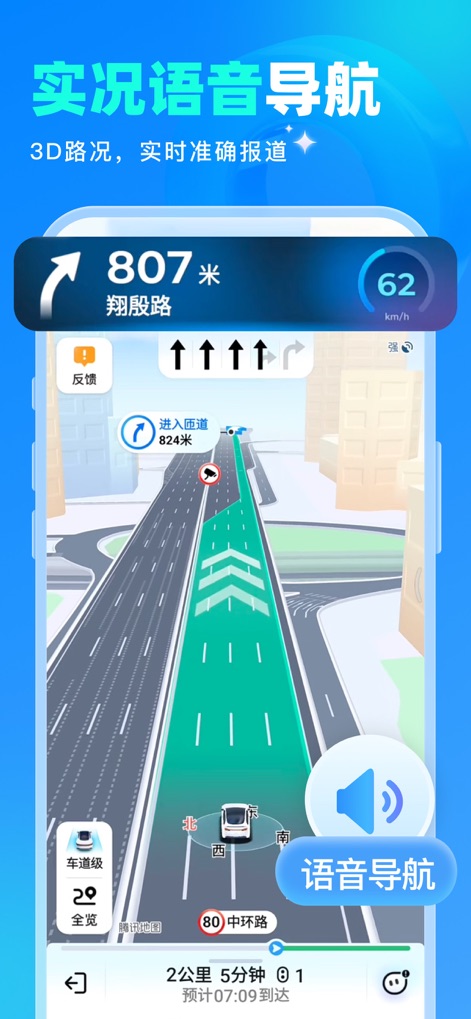
이 앱은 3D 도로 상황을 생생하게 구현하여 운전자가 복잡한 도로를 쉽게 파악하고, 실시간 음성 안내를 통해 정확한 길 찾기를 제공합니다.
몰입형 3D 내비게이션
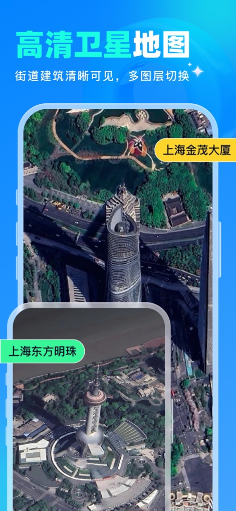
사용자는 고화질 위성 지도를 통해 도시의 건물과 자연 경관을 선명하게 탐색할 수 있으며, 다양한 레이어 전환 기능을 활용하여 상세 정보를 얻을 수 있습니다.
전 세계를 손안에
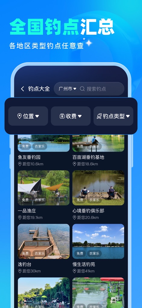
이 앱은 전국 각지의 낚시터 정보를 상세하게 제공하며, 사용자는 위치 및 유형별 필터링과 검색 기능을 사용하여 이상적인 낚시 장소를 쉽게 찾을 수 있습니다.
완벽한 낚시 동반자

사용자는 이 앱에서 전국 인기 명소와 숨겨진 보석 같은 장소들의 목록을 확인할 수 있으며, 분포 지도와 검색 기능을 활용하여 다음 여행을 쉽게 계획할 수 있습니다.
나만의 여행 탐험가
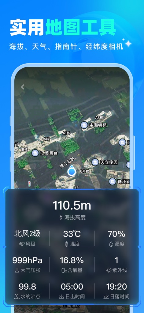
이 앱은 사용자의 현재 고도를 실시간으로 측정하여 아웃도어 활동에 도움을 주며, 풍향, 온도, 습도 등 다양한 기상 정보를 한눈에 제공합니다.
야외 활동 필수 도구
설명
Download
비슷한 앱
유사한 기능과 사용자 경험을 가진 앱

AllTrails: Hike, Bike & Run
AllTrails, Inc.

Pedometer++
Cross Forward Consulting, LLC

Organic Maps: Offline Map
Organic Maps OU

Gaia GPS: Mobile Trail Maps
Trailbehind, INC.

Offline hiking maps: Mapy.com
Seznam.cz a.s.

Hiking Map Poland
Mapa Turystyczna sp. z o.o.

MapOut
Valnova GmbH

FarOut: Offline GPS Trail Maps
Atlas Guides DE, Inc.

Norgeskart
Norgeskart AS
이 페이지는 앱이나 개발자의 공식 페이지가 아니며, 정보 제공 및 논평을 목적으로 작성된 독립 편집 간행물입니다. 명시적으로 달리 언급되지 않는 한, 해당 앱이나 개발자는 MWM, Apple, Google Play, 앱 퍼블리셔 또는 앱 개발자와 제휴, 보증, 후원, 승인 또는 공식적으로 연결되어 있지 않으며, 이 페이지의 어떤 내용도 해당 앱이 MWM의 서비스를 사용하여 개발되었음을 의미하지 않습니다. 모든 상표, 로고, 스크린샷 및 기타 콘텐츠는 해당 소유자의 자산입니다.