이 페이지는 앱이나 개발자의 공식 페이지가 아니며, 정보 제공 및 논평을 목적으로 작성된 독립 편집 간행물입니다. 명시적으로 달리 언급되지 않는 한, 해당 앱이나 개발자는 MWM, Apple, Google Play, 앱 퍼블리셔 또는 앱 개발자와 제휴, 보증, 후원, 승인 또는 공식적으로 연결되어 있지 않으며, 이 페이지의 어떤 내용도 해당 앱이 MWM의 서비스를 사용하여 개발되었음을 의미하지 않습니다. 모든 상표, 로고, 스크린샷 및 기타 콘텐츠는 해당 소유자의 자산입니다.

Acres: Land Data & Parcel Maps
토지 소유자 이름, 정확한 재산 경계, 종합적인 토양 보고서에 즉시 액세스하세요. 데스크톱에서 현장까지, 전문가를 위해 설계된 3D 지도, 과거 데이터 및 오프라인 추적 기능을 사용하여 토지 잠재력을 평가하세요.
다운로드
469K+사용자 평점
총 평가 수
1K+개발사
카테고리
Business지원 언어
1최신 버전
3.5.4크기
133.7 MB출시일
2022년 10월 4일진지한 토지 관리를 위한 정밀 도구
재산 경계를 확인하고 토양 품질을 평가하는 것부터 Acres는 이동 중에 정보에 입각한 결정을 내리는 데 필요한 종합적인 데이터를 제공합니다.
즉각적인 토지 소유자 데이터
미국 수백만 필지의 소유자와 정확한 경계를 즉시 식별하여 카운티 서기 사무실에서의 시간을 절약하세요.
심층 필지 정보
토양 구성, 과거 작물 수확량, 홍수 지역 및 지형 지도에 대한 전문가 수준의 통찰력으로 위험을 완화하세요.
자주 묻는 질문
에 대해 알아야 할 모든 것 Acres: Land Data & Parcel Maps
Acres 앱은 무엇에 사용되나요?
Acres 앱은 부동산 경계, 토지 소유자 정보, 판매용 토지를 찾는 데 사용되는 지도 제작 및 토지 분석 도구입니다. 필지 단위의 통찰력을 제공하고 부동산 지도를 저장하고 공유할 수 있습니다.
Acres 앱으로 판매용 토지를 검색할 수 있나요?
예, Acres 앱을 사용하면 미국 전역에서 판매용 토지를 즉시 찾고 공유할 수 있습니다. 이 기능은 앱 내에서 직접 액세스할 수 있습니다.
Acres는 부동산 경계를 찾는 데 어떻게 도움이 되나요?
Acres 앱을 사용하면 사용자는 정확한 부동산 경계를 확인할 수 있습니다. 또한 부동산 경계를 찾고 토지 분석을 위한 필지 단위 통찰력을 평가하는 데 도움이 됩니다.
Acres 앱은 토지 소유자 정보를 제공하나요?
예, Acres 앱은 토지 소유자 정보를 제공하며 특정 필지의 이름을 표시합니다. 이 기능은 포괄적인 토지 분석에 도움이 됩니다.
Acres 지도를 오프라인에서 사용할 수 있나요?
예, Acres는 오프라인 지도를 지원합니다. 사용자는 인터넷 연결 없이도 지도 제작 기능을 지속적으로 사용할 수 있도록 인터넷 연결이 끊긴 상태에서도 저장된 위성 보기 영역이나 사용자 지정 지도에 액세스할 수 있습니다.
Acres에는 3D 지도 시각화 기능이 포함되어 있나요?
예, Acres에는 3D 지도 시각화 기능이 포함되어 있습니다. 사용자는 3D 모드에서 지형을 시각화하고 이 기능을 켜거나 꺼서 다양한 각도에서 토지를 탐색할 수 있습니다.
Acres 앱은 경로를 추적하나요?
예, Acres 앱에는 경로 추적 기능이 있습니다. 사용자는 자신의 경로를 추적하고 저장하며 부동산을 걸어 다니면서 거리와 고도 변화를 측정할 수 있습니다.
Acres에서 사용자 지정 지도를 어떻게 만들 수 있나요?
Acres를 사용하면 사진에 지리 태그를 지정하고, 메모를 추가하고, 관심 지점을 표시하여 사용자 지정 지도를 만들 수 있습니다. 이러한 개인화된 지도는 모바일 및 데스크톱 간에 자동으로 동기화됩니다.
Acres에서 어떤 토지 데이터 레이어를 사용할 수 있나요?
Acres는 토양 지도, 고도, 과거 이미지, 식생 지수, 작물 이력, 카운티 임대료, 카운티 수확량, 재산세, 홍수/습지 정보 등 수많은 토지 데이터 레이어를 제공합니다.
Acres에서 내 지도와 토지 데이터를 공유할 수 있나요?
예, Acres를 사용하면 앱에서 직접 부동산 지도와 토지 데이터를 공유할 수 있습니다. 사용자는 지도에서 특정 웨이포인트도 공유할 수 있습니다.
Acres는 모바일 및 데스크톱 장치 간에 동기화되나요?
예, Acres는 모바일 장치와 데스크톱 간에 부동산 지도 및 사용자 지정 지도에 대한 원활한 동기화를 제공합니다. 이를 통해 다양한 플랫폼에서 지속적인 분석이 가능합니다.
Acres 앱 구독은 어떻게 청구되나요?
Acres 앱 구독은 iTunes 계정을 통해 신용카드로 청구됩니다. 현재 기간이 종료되기 최소 24시간 전에 취소하지 않는 한 자동으로 갱신됩니다.
Acres는 구독 또는 무료 평가판에 대한 환불을 제공하나요?
아니요, Acres는 기간 중에 취소하더라도 구독료에 대한 환불을 제공하지 않습니다. 무료 평가판의 사용하지 않은 부분은 구독 활성화 시 몰수됩니다.
Acres의 이용 약관 및 개인 정보 보호 정책은 어디에서 읽을 수 있나요?
Acres의 이용 약관 및 개인 정보 보호 정책은 웹사이트에서 확인할 수 있습니다. 사용자는 www.acres.com/terms-of-use 및 www.acres.com/privacy-policy의 제공된 링크를 통해 이러한 문서에 액세스할 수 있습니다.
Acres 앱에는 광고가 포함되어 있나요?
아니요, Acres 앱에는 광고가 포함되어 있지 않습니다. 사용자는 모든 기능을 사용하는 동안 광고 없는 인터페이스를 경험할 수 있습니다.
다음 스크린샷과 설명은 앱의 공식 스토어 목록에서 직접 가져온 것이며 앱 개발자의 자산입니다.
앱 스토어
스크린샷
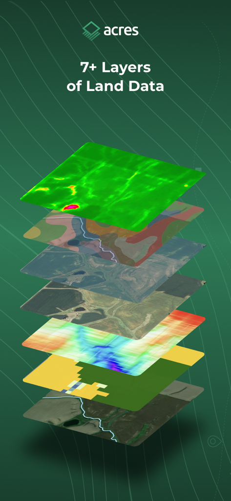
Acres 앱의 위성 보기, 지형 및 토양 정보를 보여주는 일곱 가지 다른 지도 데이터 레이어 스택
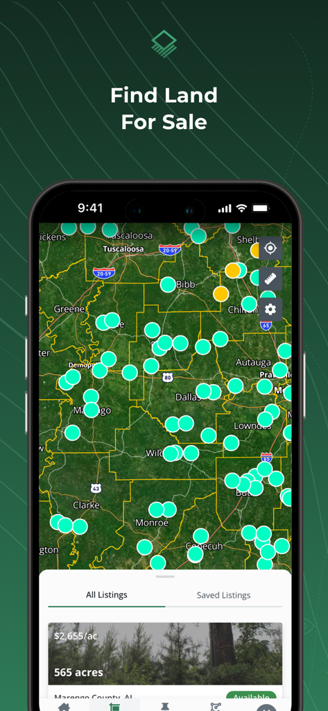
Acres 앱 지도 보기에 판매용 토지 목록 및 재산 핀 표시
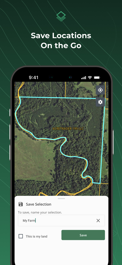
Acres 앱 인터페이스에 강조 표시된 토지 필지 및 선택 항목을 저장하라는 메시지가 표시된 위성 지도 표시
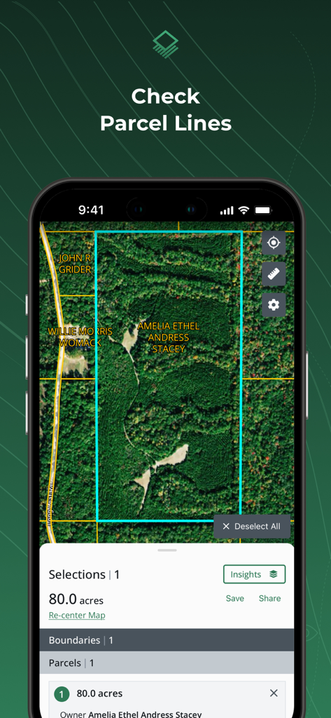
Acres 앱 인터페이스에 위성 지도에 토지 필지 경계 및 토지 소유자 정보 표시
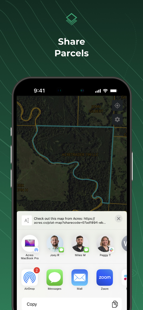
Acres 앱의 필지 공유 기능, 토지 지도 및 공유 옵션이 표시된 iPhone 화면
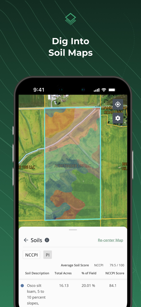
Acres 앱이 표시된 휴대폰 화면에 특정 토지 필지에 대한 다채로운 토양 지도 오버레이 및 상세한 토양 구성 데이터 표시
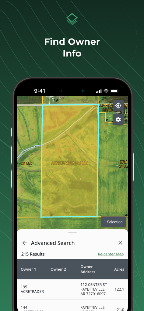
Acres 앱 인터페이스에 위성 지도에 토지 소유자 이름 및 재산 필지 세부 정보 표시
설명
Download
비슷한 앱
유사한 기능과 사용자 경험을 가진 앱

LandGlide: Find Property Lines
Real Estate Portal USA, LLC

Regrid Property App
Loveland Technologies, LLC

DealCheck: Analyze Real Estate
Fortnoff Financial LLC

Reventure App
Reventure App LLC

Land id®
MapRight, LLC

Tapusor
TUVIMER ARGE FAALIYETLERI VE TEKNOLOJI SISTEMLERITICARET ANONIM SIRKETI

Endeksa: Value & Sell Property
Endeksa Teknoloji Anonim Sirketi

Detector Maps
GOLD DISCOVERY SOLUTIONS PTY LTD

Parceled Land Map
Uri Nemirovsky
이 페이지는 앱이나 개발자의 공식 페이지가 아니며, 정보 제공 및 논평을 목적으로 작성된 독립 편집 간행물입니다. 명시적으로 달리 언급되지 않는 한, 해당 앱이나 개발자는 MWM, Apple, Google Play, 앱 퍼블리셔 또는 앱 개발자와 제휴, 보증, 후원, 승인 또는 공식적으로 연결되어 있지 않으며, 이 페이지의 어떤 내용도 해당 앱이 MWM의 서비스를 사용하여 개발되었음을 의미하지 않습니다. 모든 상표, 로고, 스크린샷 및 기타 콘텐츠는 해당 소유자의 자산입니다.