이 페이지는 앱이나 개발자의 공식 페이지가 아니며, 정보 제공 및 논평을 목적으로 작성된 독립 편집 간행물입니다. 명시적으로 달리 언급되지 않는 한, 해당 앱이나 개발자는 MWM, Apple, Google Play, 앱 퍼블리셔 또는 앱 개발자와 제휴, 보증, 후원, 승인 또는 공식적으로 연결되어 있지 않으며, 이 페이지의 어떤 내용도 해당 앱이 MWM의 서비스를 사용하여 개발되었음을 의미하지 않습니다. 모든 상표, 로고, 스크린샷 및 기타 콘텐츠는 해당 소유자의 자산입니다.
Detector Maps
금을 찾는 데 도움을 주기 위해 지질학자들이 개발했습니다. 호주, 미국, 뉴질랜드 전역에서 실시간 채광권, 고해상도 LiDAR, 오프라인 GPS 흔적 추적을 이용하세요.
금 발견과 험준한 지형 탐색에 대한 절대적인 자신감을 가질 수 있도록 설계된 전문가 수준의 지질 데이터 및 오프라인 GPS 도구입니다.
실시간 채광권 데이터
미국 및 호주 전역의 활성 채광 임대 및 토지 경계에 대한 일일 업데이트로 명성을 보호하고 법적 벌금을 피하세요.
정밀 흔적 추적
백그라운드에서 정확한 경로를 기록하여 효율성을 극대화하고, 이미 탐사한 지역을 다시 탐사하는 데 시간을 낭비하지 않도록 합니다.
다음 스크린샷과 설명은 앱의 공식 스토어 목록에서 직접 가져온 것이며 앱 개발자의 자산입니다.
앱 스토어
스크린샷
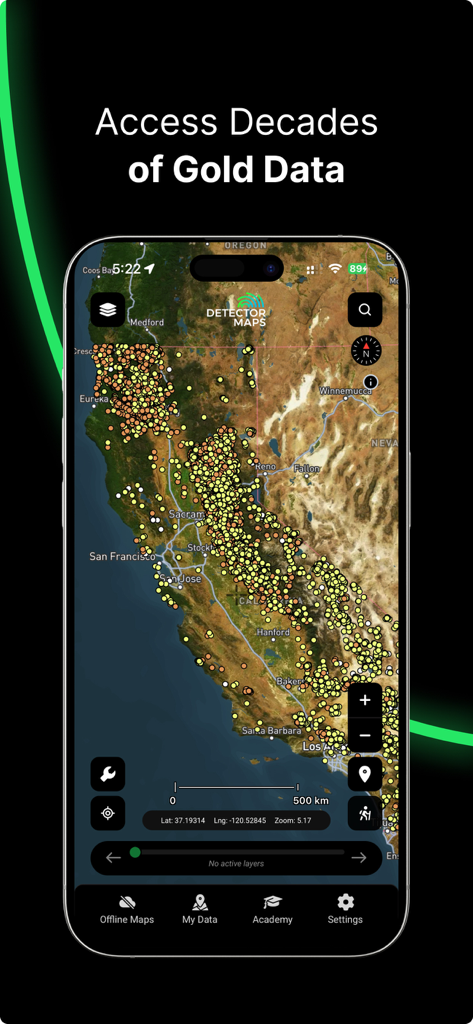
Detector Maps 앱 인터페이스가 캘리포니아 지도에 걸쳐 과거 금 데이터 포인트를 표시합니다
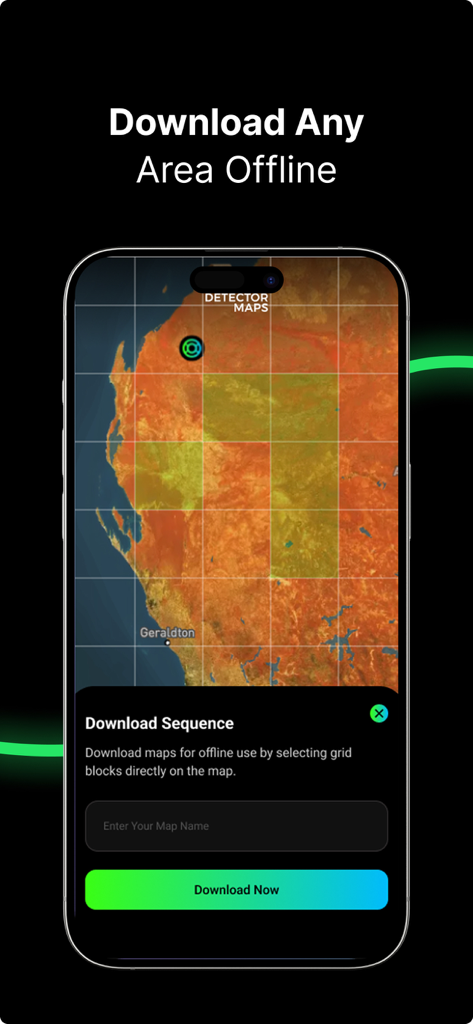
Detector Maps 앱 인터페이스가 오프라인 지도 다운로드를 위한 그리드 블록을 선택하는 방법을 보여줍니다
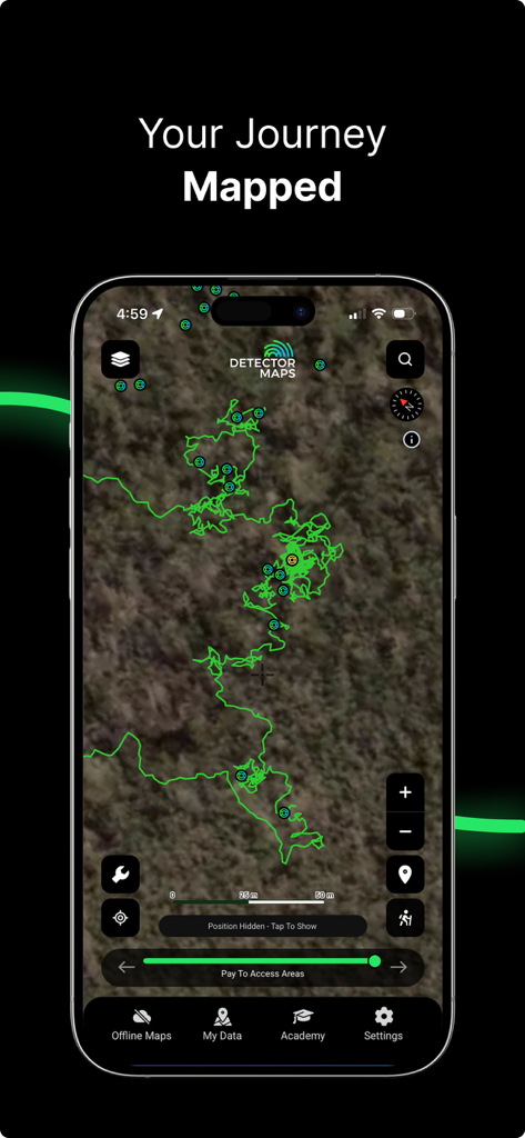
Detector Maps 금 탐사 앱 내 지도에 녹색 흔적 추적이 표시된 스마트폰 화면
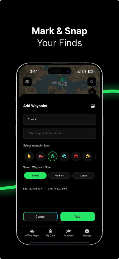
Detector Maps 앱 화면이 발견을 위해 웨이포인트를 표시하고 저장하는 방법을 보여줍니다.
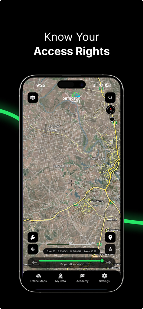
금 탐사를 위한 상세 위성 지도에 부동산 경계 및 토지 접근 권한을 보여주는 모바일 앱 스크린샷
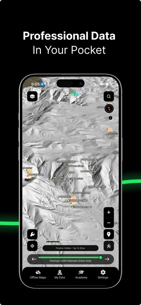
Detector Maps 앱 인터페이스가 상세한 LiDAR 힐셰이드 지형 및 금 광산 위치를 보여줍니다
설명
Detector Maps is your ultimate field tool for gold prospecting in Australia, the United States, and New Zealand.
Built by geologists for real prospectors, it combines advanced geological datasets with intuitive GPS tools so you can explore smarter, stay on the gold, and avoid wasting time on low-potential ground, even offline.
Whether you are swinging a detector, panning a creek, or hiking into remote country, Detector Maps puts rich geological intelligence in your pocket.
WHAT MAKES DETECTOR MAPS DIFFERENT
Advanced geological and gold-focused data.
Built and curated specifically for prospectors.
Optimised for mobile and offline field use.
Included layers (where available):
Surface geochemistry and filtering.
Historic gold mines and workings.
Current and expired mining leases / claims (updated every weekday).
Optional LiDAR hillshade add-on for ultra-detailed terrain reading.
BREADCRUMB TRAIL TRACKING (BACKGROUND GPS)
Record your exact trail, even when the app is in the background or your screen is off.
Avoid going over the same old ground twice.
Log your exploration paths for future trips and follow-ups.
WHY WE REQUEST “ALWAYS ALLOW” LOCATION ACCESS
Detector Maps only uses background location when breadcrumb tracking is turned ON by you.
This ensures a complete, accurate log of your journey.
Tracking continues even while your phone is idle or the screen is off to save battery.
You can disable background tracking at any time in the app or in device settings.
OFFLINE ACCESS ANYWHERE
Download detailed map tiles and data layers for offline use.
GPS position, trails, and waypoints keep working without mobile reception.
Perfect for remote trips and off-grid prospecting.
WAYPOINT MARKING AND FIELD NOTES
Drop waypoints for gold finds, test pits, quartz outcrops, hot targets, old workings, camps and more.
Add names, notes, and categories so you remember exactly what you found and where.
Sync waypoints to your account so they are backed up and available across devices.
REAL-TIME GPS NAVIGATION
Track your live position with precision in the field.
See leases, boundaries, geology and terrain features as you move.
Use Detector Maps as your dedicated gold prospecting GPS companion.
COVERAGE
AUSTRALIA
Full coverage across all major gold-producing states: QLD, NSW, VIC, WA, SA, TAS and NT.
UNITED STATES
State coverage: California, Alabama, North Carolina, Arizona, Nevada, Idaho, Oregon, Utah, Colorado, Montana, Washington, South Carolina, Virginia, Georgia, New Mexico.
NEW ZEALAND
Goldfields coverage with historic mining data, geology layers, and offline maps.
SUBSCRIPTION INFORMATION
All States / All Countries access plans include all maps and standard layers, offline downloads, and coverage for Australia, USA and New Zealand.
USA pricing:
Monthly: 9.99 USD
Yearly: 99 USD
AUS/NZ pricing:
Monthly: 9.99 AUD
Yearly: 99 AUD
Payment is charged to your Apple ID account at confirmation of purchase.
Subscriptions automatically renew unless cancelled at least 24 hours before the end of the current period.
You can manage or cancel your subscription at any time in your App Store account settings.
Pricing may vary by region.
PRIVACY AND DATA
Your location, trails, and waypoints are only used for core app functionality (maps, GPS, trails, and waypoints).
You can permanently delete your account at any time: Profile > Delete Account > type “confirm” > tap the red Delete button.
Privacy Policy: https://app.detectormaps.com/privacy-policy
Terms of Use (EULA): https://app.detectormaps.com/license-agreement
BUILT FOR REAL PROSPECTORS
Whether you swing a GPX 6000, SDC, Gold Monster, other detector, sluice or just a pan, Detector Maps helps you cover more ground, log and revisit your best spots, and explore gold-rich terrain using professional-grade geological data in your pocket.
Start your next gold mission with confidence.
이 페이지는 앱이나 개발자의 공식 페이지가 아니며, 정보 제공 및 논평을 목적으로 작성된 독립 편집 간행물입니다. 명시적으로 달리 언급되지 않는 한, 해당 앱이나 개발자는 MWM, Apple, Google Play, 앱 퍼블리셔 또는 앱 개발자와 제휴, 보증, 후원, 승인 또는 공식적으로 연결되어 있지 않으며, 이 페이지의 어떤 내용도 해당 앱이 MWM의 서비스를 사용하여 개발되었음을 의미하지 않습니다. 모든 상표, 로고, 스크린샷 및 기타 콘텐츠는 해당 소유자의 자산입니다.