이 페이지는 앱이나 개발자의 공식 페이지가 아니며, 정보 제공 및 논평을 목적으로 작성된 독립 편집 간행물입니다. 명시적으로 달리 언급되지 않는 한, 해당 앱이나 개발자는 MWM, Apple, Google Play, 앱 퍼블리셔 또는 앱 개발자와 제휴, 보증, 후원, 승인 또는 공식적으로 연결되어 있지 않으며, 이 페이지의 어떤 내용도 해당 앱이 MWM의 서비스를 사용하여 개발되었음을 의미하지 않습니다. 모든 상표, 로고, 스크린샷 및 기타 콘텐츠는 해당 소유자의 자산입니다.
Airmate
전문가 수준의 이동 지도, FAA 차트 및 실시간 상황 인식 기능으로 조종석을 한 단계 끌어올리세요. 비싼 구독료 없이 모든 기능을 갖춘 전자 비행 가방의 성능을 경험해 보세요.
주요 수치
다운로드
438K+
사용자 평점
4.7/5
총 평가 수
100
개발사
Myriel Aviation SA
카테고리
Navigation
지원 언어
7
최신 버전
3.20
크기
219.5 MB
출시일
2017년 7월 22일
기능
전문 EFB로 하늘을 정복하세요
Airmate는 구독 피로감 없이 전문가 수준의 신뢰성을 요구하는 일반 항공 조종사를 위해 설계된 포괄적인 비행 계획, 항법 및 안전 도구 모음을 제공합니다.
미국 전체 비행 계획
미국 및 200개 이상 국가에서 몇 초 만에 VFR 또는 IFR 비행 계획을 제출할 수 있는 무료 FAA 섹셔널, 터미널 절차 및 자동 경로 도구를 이용하세요.
향상된 상황 인식
3D 시뮬레이션 비전, 백업 EFIS 및 실시간 ADS-B 교통 통합으로 안전을 강화하여 어떤 환경에서도 항공기보다 앞서나가세요.
FAQ
자주 묻는 질문
에 대해 알아야 할 모든 것 Airmate
Airmate 앱은 무엇인가요?
Airmate는 조종사를 위한 무료이며 사용하기 쉬운 비행 계획 및 날씨 앱으로, 상황 인식 능력을 향상시키고 필수 항공 데이터 및 지도에 즉시 액세스할 수 있도록 설계되었습니다.
Airmate는 조종사를 위한 무료 앱인가요?
네, Airmate는 무료 앱입니다. 전 세계 항공 데이터베이스 및 지형도에 무료로 액세스할 수 있으며 무료 업데이트를 제공합니다.
Airmate는 IFR 및 VFR 공항 정보를 제공하나요?
네, Airmate는 IFR 및 VFR 공항 정보를 제공합니다. 이 정보는 미국(FAA 차트), 유럽 및 200개 이상의 다른 국가에서 무료로 제공되며, 많은 정보가 지오레퍼런싱됩니다.
Airmate는 비행 중 날씨 정보를 표시할 수 있나요?
네, Airmate는 비행 중 날씨를 표시할 수 있습니다. 외부 ADS-B 수신기와 함께 사용하면 FIS-B 날씨를 수신하며, 최신 날씨 정보와 NOTAM을 포함합니다.
Airmate는 비행 계획에 어떻게 도움이 되나요?
Airmate는 최적의 경로를 선택하는 자동 경로 기능, VFR/IFR 비행 계획 제출, 제출된 계획 관리/지연/취소 기능을 제공하여 비행 계획을 돕습니다.
Airmate는 비행 중 교통 정보를 표시하나요?
네, Airmate는 교통 정보를 표시합니다. 외부 ADS-B 수신기를 통해 이동 지도에서 주변 교통 정보를 표시하거나, 모바일 네트워크를 통해 상업용 항공기 및 기타 항공기를 포함한 주변 항공기 정보를 표시합니다.
Airmate는 항공기 자세 표시기를 시뮬레이션할 수 있나요?
네, Airmate는 항공기 자세 표시기를 시뮬레이션할 수 있습니다. 비행 중 EFIS와 유사한 보기로 백업 자세 표시기 및 비행 매개변수를 표시합니다.
Airmate는 합성 시야(Synthetic Vision) 기능을 제공하나요?
네, Airmate는 합성 시야 기능을 제공합니다. 이 기능은 EFIS와 유사한 보기로 전방의 지형을 표시하며 전 세계에서 사용할 수 있습니다. 경치 데이터는 일부 국가에서 구매하여 사용할 수 있습니다.
Airmate는 어떤 종류의 항공 데이터를 제공하나요?
Airmate는 공항, 항법 비컨, 경유지, 항로, 장애물 및 규제/제한 구역을 포함한 전 세계 항공 데이터베이스를 무료로 업데이트하여 제공합니다. 또한 지형도 및 고도 데이터도 제공합니다.
Airmate는 비행 기록 및 재생 기능을 제공하나요?
네, Airmate는 비행을 기록할 수 있습니다. 사용자는 나중에 비행을 다시 재생하고, GPX 형식으로 비행 경로를 내보내고, 비행한 비행으로부터 조종사 로그 항목을 자동으로 계산할 수 있습니다.
Airmate는 여러 장치에서 데이터를 동기화하나요?
네, Airmate는 장치 간에 데이터를 동기화합니다. 계획된 비행 및 비행 기록, 사용자 경유지, 사용자 항공기를 클라우드에 저장하고 장치와 Airmate 웹 비행 계획 간에 동기화합니다.
다음 스크린샷과 설명은 앱의 공식 스토어 목록에서 직접 가져온 것이며 앱 개발자의 자산입니다.
앱 스토어
스크린샷
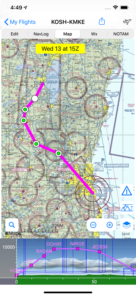
Airmate 앱이 항공 도식 차트 위에 비행 경로와 수직 프로필 보기를 표시하고 있습니다.
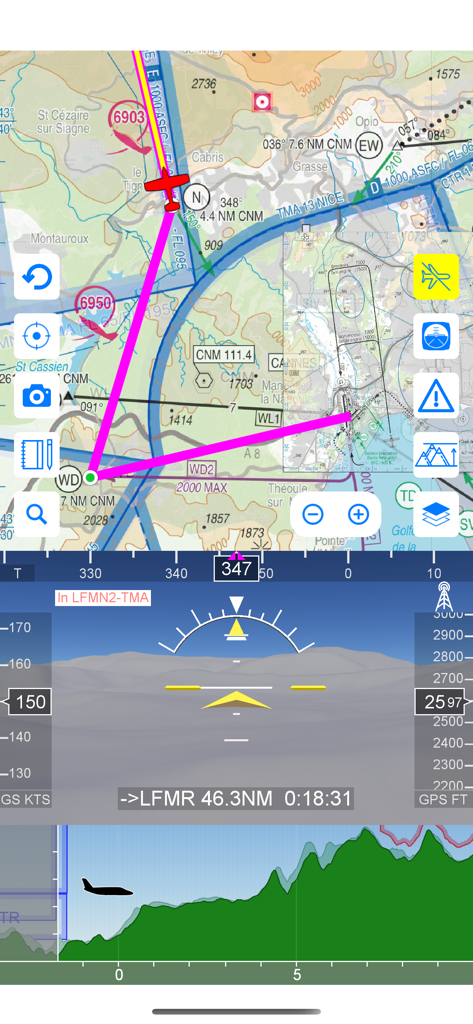
Airmate 앱이 이동식 항공 도식 지도 EFIS와 시뮬레이션 비전 및 비행 프로필을 표시하고 있습니다.
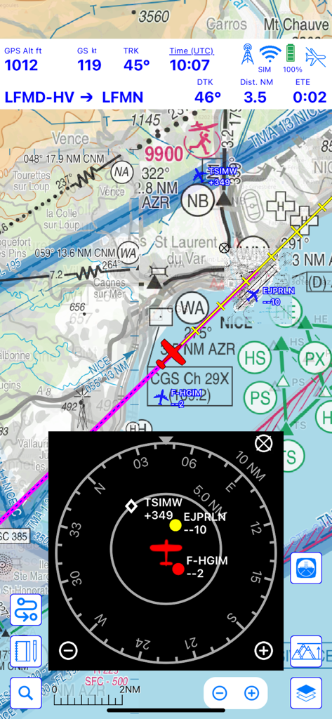
Airmate 비행 항법 인터페이스가 이동식 지도에 통합 교통 레이더 및 비행 원격 측정을 표시하고 있습니다.
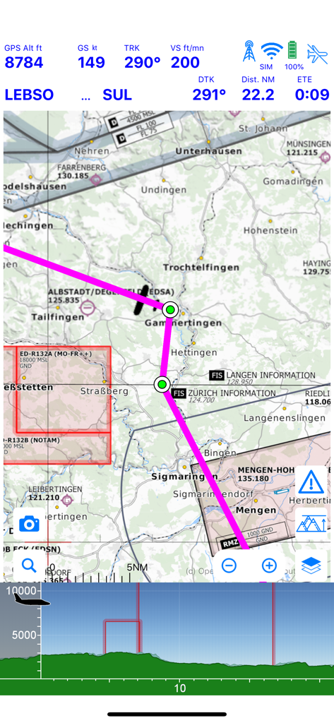
Airmate 앱 이동식 지도 디스플레이에 비행 원격 측정 및 지형 프로필이 표시되고 있습니다.
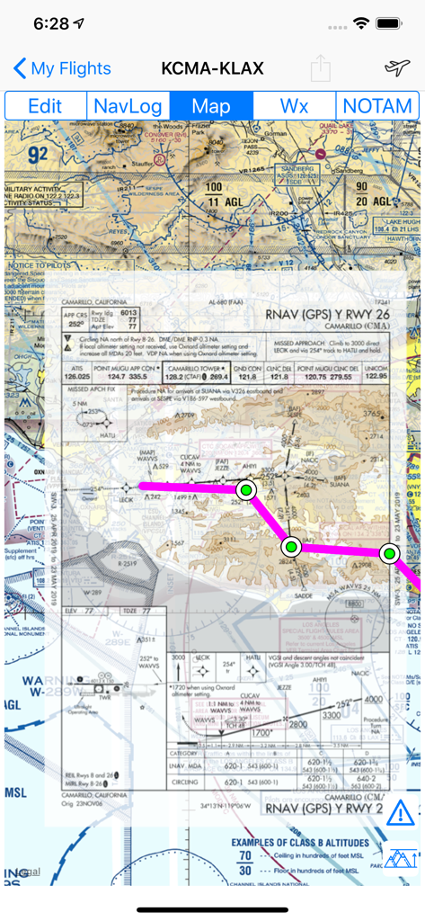
Airmate 앱 인터페이스가 이동식 지도 위에 FAA 계기 접근 차트를 표시하고 있습니다.
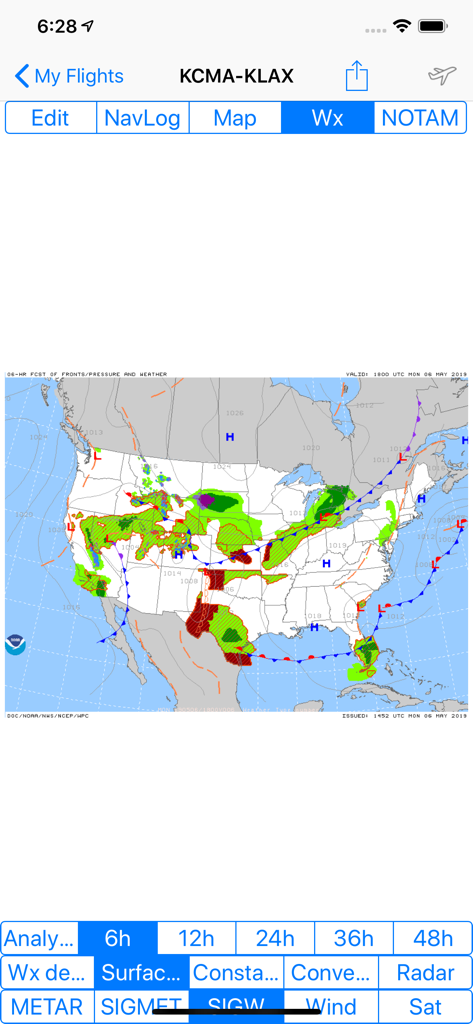
Airmate 앱 디스플레이가 미국 전역의 전선 및 기압계를 표시하는 중요한 날씨 예보 지도를 보여줍니다.
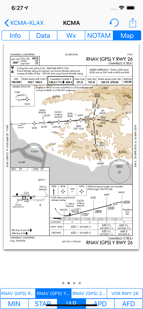
Airmate 앱이 캘리포니아 카마릴로 공항의 FAA RNAV GPS 계기 접근 차트를 표시하고 있습니다.
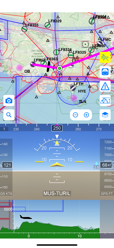
Airmate 비행 앱 인터페이스가 이동식 항공 도식 지도, 전자 비행 계기 및 지형 고도 프로필을 특징으로 합니다.
설명
Airmate is a free and easy to use flight planning and weather app for pilots, improving situational awareness and providing instant access to airport data and aviation maps, up to date weather and NOTAMs, traffic around.
IFR and VFR airport plates are freely available in US (FAA charts), Europe, and more than 200 other countries. Many of them are georeferenced and could be overlaid on the aviation chart. A powerful Plate Manager allows to download in advance all airport plates in a country, they could be easily printed and viewed.
During the flight, the moving map will display the aircraft location along the route, show airports and aeronautical data details and traffic around, warn you if your planned route is crossing restricted areas. A profile view is available to display terrain elevation, crossed areas and forecasted weather across the route. Airmate can also display a backup aircraft attitude indicator and flight parameters in an EFIS-like view. In the whole world, Synthetic Vision displaying in the EFIS-like view the ups and downs of rolling terrain ahead is available. In selected countries, Airmate can display scenery if this option is purchased.
Airmate includes a worldwide aeronautical database updated free of charge with airports, navigation beacons, waypoints, airways, obstacles, regulated and restricted areas. Topographic maps and elevation data for most countries may be downloaded free of charge, as well as additional aviation map overlays such US Sectionals. A procedure database provide details of departure (SID), arrival (STAR) and instrument approaches in the USA, and you could add those procedures to your planned flight route (the procedure database includes all US airports, we are workding to add airports in other countries). Once loaded, the procedure path is displayed on the aeronautical map, including curved paths and racetracks.
When coupled with a supported external ADS-B received, Airmate will display nearby traffic on the moving map, and receive FIS-B weather and NOTAM during the flight. To improve safety, Airmate can display neighbouring traffic received over mobile network. Such traffic include commercial airlines and transponder-equiped aircrafts, FLARM gliders, aircrafts whose pilots are using Airmate and other users using other safety broadcasting equipment.
Airmate is able to transmit the flight plan data to supported avionics such Dynon SkyView.
Thanks to the Auto Route feature, you could search and select the best route for your flight, and then file your VFR or IFR flight plan. Once filed, your flight plan could easily be managed, delayed or cancelled.
Airmate will also record your flights and allow to replay them later or export the flight path in gpx format, you could take pictures from the app during flights. Pilot log entries are automatically computed from flown flights.
A Satellite map display mode in flight planning or replay mode allows to familiarize with significant landmarks.
Airmate will save planned and flown flights, user waypoints and user aircrafts in the cloud and sync them between your devices and Airmate web flight planning.
Airmate brings numerous social features to the community. Pilots may leave ratings, tips and comments to share their experience with fellow pilots, and report fuel prices and landing fees. They could find friends, instructors, flight schools, aviation events and aircraft to rent near their home airport or any visited airport.
Airmate may be connected to most flight simulators to keep flying skills sharp, and will manage also AHRS and simulated traffic data transmitted by the flight simulator. Planned flights and personal waypoints may be imported and exported.
Continued use of GPS running in the background can dramatically decrease battery life.
Terms of Use: https://www.apple.com/legal/internet-services/itunes/dev/stdeula/
이 페이지는 앱이나 개발자의 공식 페이지가 아니며, 정보 제공 및 논평을 목적으로 작성된 독립 편집 간행물입니다. 명시적으로 달리 언급되지 않는 한, 해당 앱이나 개발자는 MWM, Apple, Google Play, 앱 퍼블리셔 또는 앱 개발자와 제휴, 보증, 후원, 승인 또는 공식적으로 연결되어 있지 않으며, 이 페이지의 어떤 내용도 해당 앱이 MWM의 서비스를 사용하여 개발되었음을 의미하지 않습니다. 모든 상표, 로고, 스크린샷 및 기타 콘텐츠는 해당 소유자의 자산입니다.