이 페이지는 앱이나 개발자의 공식 페이지가 아니며, 정보 제공 및 논평을 목적으로 작성된 독립 편집 간행물입니다. 명시적으로 달리 언급되지 않는 한, 해당 앱이나 개발자는 MWM, Apple, Google Play, 앱 퍼블리셔 또는 앱 개발자와 제휴, 보증, 후원, 승인 또는 공식적으로 연결되어 있지 않으며, 이 페이지의 어떤 내용도 해당 앱이 MWM의 서비스를 사용하여 개발되었음을 의미하지 않습니다. 모든 상표, 로고, 스크린샷 및 기타 콘텐츠는 해당 소유자의 자산입니다.

SkyDemon
유럽에서 가장 직관적인 벡터 차트, 실시간 가상 레이더, 정밀함에 중점을 둔 조종사를 위한 지능형 안전 알림으로 하늘을 마스터하세요.
다운로드
546K+사용자 평점
총 평가 수
17K+개발사
카테고리
Navigation지원 언어
-최신 버전
4.2.3크기
55.2 MB출시일
2012년 2월 10일탁월한 정밀도로 하늘을 마스터하세요
iPad를 전문가 수준의 전자 비행 가방으로 변환하세요. 모든 VFR 임무에 대해 수천 명의 조종사가 당사의 정교한 벡터 차트와 실시간 안전 도구를 신뢰하는 이유를 경험해 보세요.
비교할 수 없는 시각적 명확성
세계에서 가장 읽기 쉬운 항공 차트를 경험하세요. 동적 벡터 지도는 산만함을 제거하여 모든 확대/축소 수준에서 가장 관련성 있는 영공 및 네비게이션 데이터만 제공합니다.
혁신적인 가상 레이더
완벽한 상황 인식으로 비행하세요. 비행 경로의 측면 투영을 통해 지형, 장애물 및 제한된 영공에 도달하기 훨씬 전에 이를 강조 표시합니다.
자주 묻는 질문
에 대해 알아야 할 모든 것 SkyDemon
SkyDemon이란 무엇인가요?
SkyDemon은 유럽에서 선호하는 VFR 비행 계획 및 비행 중 항법 소프트웨어로, 구독을 통해 iOS 기기에서 사용할 수 있습니다.
SkyDemon은 비행 위험에 대한 경고를 제공하나요?
SkyDemon으로 VFR 비행 계획을 제출할 수 있나요?
네, SkyDemon을 사용하면 사용자가 계획한 경로에 대한 VFR 비행 계획을 항공 교통 관제사에게 직접 제출할 수 있습니다.
SkyDemon은 강우량 데이터를 표시하나요?
네, SkyDemon은 계획 중에 시간에 따른 강우량 추세를 보여주는 애니메이션 강우량 데이터를 메인 지도에 오버레이할 수 있습니다.
SkyDemon은 어떤 종류의 차트를 사용하나요?
SkyDemon은 유럽 전역에서 명확하고 가독성이 뛰어나도록 설계된 동적 영공 클리핑 및 선택 가능한 지도 레이어가 있는 벡터 차트를 사용합니다.
SkyDemon은 비행 중에 다른 항공기를 보여주나요?
네, SkyDemon은 다른 항공기에 대한 경고를 표시하며, 상대적 위치(예: '앞에 항공기, 11시 방향'), 거리 및 고도를 포함합니다.
SkyDemon은 날씨 브리핑을 제공하나요?
SkyDemon은 계획 중에 자동 TAF, METAR 및 SIGMET 브리핑을 그래픽 디코딩과 함께 제공합니다. 인터넷 연결이 있는 경우 비행 중에도 실시간 업데이트가 가능합니다.
SkyDemon의 지리적 적용 범위는 어떻게 되나요?
네, SkyDemon은 표준으로 광범위한 유럽 차트 적용 범위를 제공하여 유럽에서 가장 선호하는 VFR 비행 계획 소프트웨어입니다.
다음 스크린샷과 설명은 앱의 공식 스토어 목록에서 직접 가져온 것이며 앱 개발자의 자산입니다.
앱 스토어
스크린샷
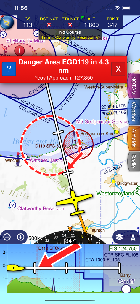
SkyDemon 비행 네비게이션 인터페이스에 빨간색 위험 구역 경고와 가상 레이더 측면 투영이 표시됨
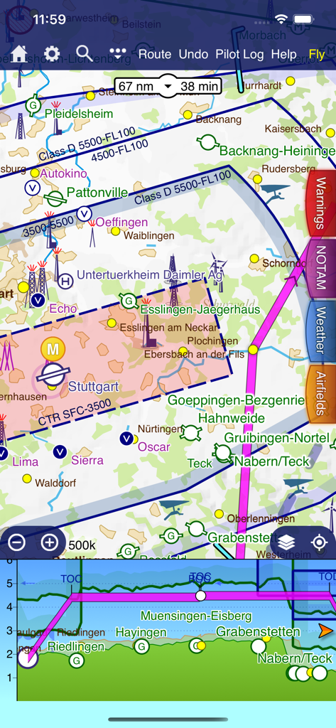
SkyDemon 비행 계획 인터페이스에 벡터 지도와 가상 레이더 측면 투영이 표시됨
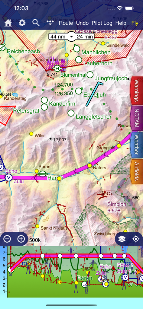
SkyDemon VFR 네비게이션 지도와 가상 레이더 지형 보기
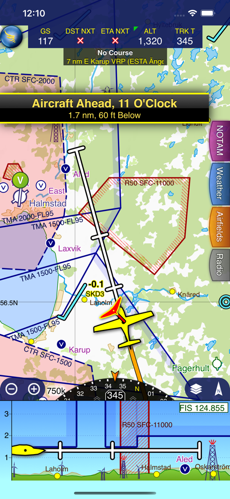
SkyDemon 앱 화면에 벡터 지도, 항공기 트래픽 경고 및 가상 레이더가 표시된 비행 중 네비게이션이 표시됨
설명
Download
비슷한 앱
유사한 기능과 사용자 경험을 가진 앱

Navigraph Charts
Navigraph KB

Airports
Applicate Ltd

OzRunways EFB
OzRunways Pty. Ltd.

fDeck: flight instruments
Darren Yeates

Noisy Goose
Automata Solutions Ltd.

StationWeather - METAR and TAF
Oliver Puetz

Drone UAV Fly Forecast: AirMap
MONIQ TAP COMPANY LIMITED

Airmate
Myriel Aviation SA

AvPlan EFB
BJA Consulting Pty Ltd
이 페이지는 앱이나 개발자의 공식 페이지가 아니며, 정보 제공 및 논평을 목적으로 작성된 독립 편집 간행물입니다. 명시적으로 달리 언급되지 않는 한, 해당 앱이나 개발자는 MWM, Apple, Google Play, 앱 퍼블리셔 또는 앱 개발자와 제휴, 보증, 후원, 승인 또는 공식적으로 연결되어 있지 않으며, 이 페이지의 어떤 내용도 해당 앱이 MWM의 서비스를 사용하여 개발되었음을 의미하지 않습니다. 모든 상표, 로고, 스크린샷 및 기타 콘텐츠는 해당 소유자의 자산입니다.