이 페이지는 앱이나 개발자의 공식 페이지가 아니며, 정보 제공 및 논평을 목적으로 작성된 독립 편집 간행물입니다. 명시적으로 달리 언급되지 않는 한, 해당 앱이나 개발자는 MWM, Apple, Google Play, 앱 퍼블리셔 또는 앱 개발자와 제휴, 보증, 후원, 승인 또는 공식적으로 연결되어 있지 않으며, 이 페이지의 어떤 내용도 해당 앱이 MWM의 서비스를 사용하여 개발되었음을 의미하지 않습니다. 모든 상표, 로고, 스크린샷 및 기타 콘텐츠는 해당 소유자의 자산입니다.

Autobahn Map
무제한 구간을 시각화하고, 경로 속도 제한을 분석하고, 정밀하게 궁극의 고속 로드 트립을 계획하는 열정가와 여행자를 위한 필수 동반자입니다.
다운로드
1K+사용자 평점
총 평가 수
0개발사
카테고리
Navigation지원 언어
1최신 버전
1.0크기
60.9 MB출시일
2025년 11월 17일전설적인 아우토반 정복하기
독일을 탐험하는 고속 열정가와 전략적인 로드 트립퍼를 위한 최고의 툴킷으로 기본 내비게이션을 넘어서세요.
무제한 구간 찾기
색상 구분된 속도 구간으로 네트워크를 시각화하세요. 버킷 리스트 드라이브를 위해 상징적인 '무제한' 파란색 구간을 즉시 발견하세요.
여정 최적화
경로를 계산하고 속도 제한의 통계적 분석을 확인하세요. 기어를 바꾸기 전에 여행의 얼마나 많은 부분이 제한이 없는지 정확히 알아보세요.
다음 스크린샷과 설명은 앱의 공식 스토어 목록에서 직접 가져온 것이며 앱 개발자의 자산입니다.
앱 스토어
스크린샷
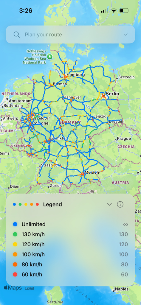
색상 구분된 속도 제한 구간과 범례로 독일 아우토반 네트워크를 강조하는 독일 지도.
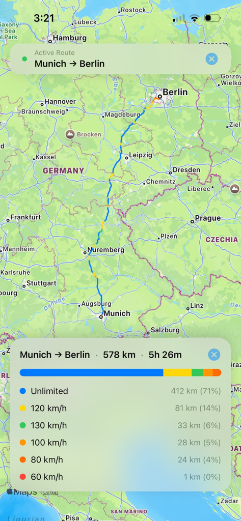
아우토반 지도 앱이 뮌헨에서 베를린까지의 경로를 표시하며 속도 제한 및 무제한 구간의 상세 분석을 제공합니다.
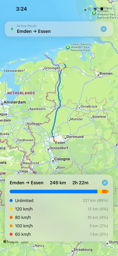
아우토반 지도 인터페이스가 엠덴에서 에센까지의 경로 통계 및 속도 제한 구간을 표시합니다.
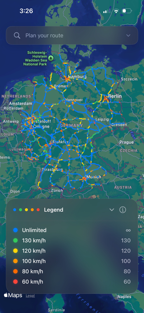
독일의 색상 구분된 지도와 속도 제한 및 무제한 구간 범례를 보여주는 아우토반 지도 앱 스크린샷.
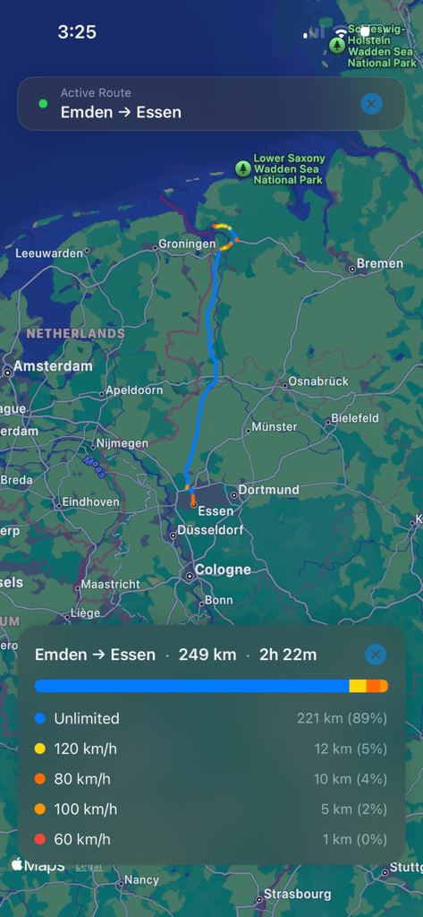
아우토반 지도 앱 인터페이스가 엠덴에서 에센까지의 경로에 대한 속도 제한 비율을 표시합니다.
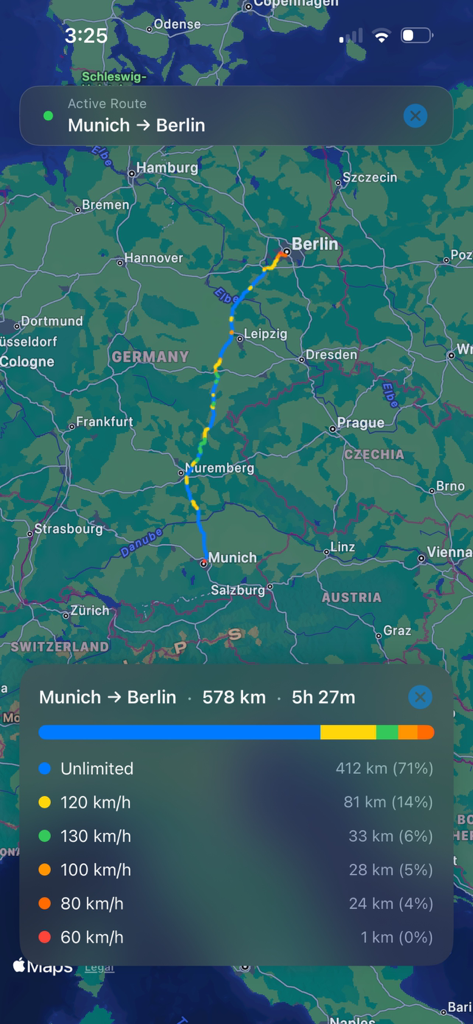
뮌헨에서 베를린까지의 경로를 표시하는 지도에 속도 제한 구간 및 무제한 구간의 상세 분석이 포함되어 있습니다.
설명
Download
비슷한 앱
같은 카테고리의 상위 앱

Google Maps
Google LLC

Waze Navigation & Live Traffic
waze

AMap Global
AutoNavi Information Technology Co. Ltd.

百度地图-路线规划,出行必备
Beijing Baidu Netcom Science & Technology Co.,Ltd

Moovit: Bus & Transit Tracker
Moovit App Global LTD

Transit • Subway & Bus Times
9280-0366 Quebec inc.

ParkMobile: Park. Pay. Go.
Parkmobile USA, Inc

腾讯地图-路线规划,导航地铁打车出行
Shenzhen Tencent Computer Systems Company Limited

Île-de-France Mobilités
Ile de France Mobilites
이 페이지는 앱이나 개발자의 공식 페이지가 아니며, 정보 제공 및 논평을 목적으로 작성된 독립 편집 간행물입니다. 명시적으로 달리 언급되지 않는 한, 해당 앱이나 개발자는 MWM, Apple, Google Play, 앱 퍼블리셔 또는 앱 개발자와 제휴, 보증, 후원, 승인 또는 공식적으로 연결되어 있지 않으며, 이 페이지의 어떤 내용도 해당 앱이 MWM의 서비스를 사용하여 개발되었음을 의미하지 않습니다. 모든 상표, 로고, 스크린샷 및 기타 콘텐츠는 해당 소유자의 자산입니다.