이 페이지는 앱이나 개발자의 공식 페이지가 아니며, 정보 제공 및 논평을 목적으로 작성된 독립 편집 간행물입니다. 명시적으로 달리 언급되지 않는 한, 해당 앱이나 개발자는 MWM, Apple, Google Play, 앱 퍼블리셔 또는 앱 개발자와 제휴, 보증, 후원, 승인 또는 공식적으로 연결되어 있지 않으며, 이 페이지의 어떤 내용도 해당 앱이 MWM의 서비스를 사용하여 개발되었음을 의미하지 않습니다. 모든 상표, 로고, 스크린샷 및 기타 콘텐츠는 해당 소유자의 자산입니다.

bergfex: Hiking & Tracking
진지한 아웃도어 운동선수를 위한 지형 정밀도, 고급 안전 기능, 원활한 데이터 동기화로 지형을 정복하세요. 로키 산맥부터 알프스까지, 자신감을 가지고 오프 그리드에서 길을 찾으세요.
다운로드
2M+사용자 평점
총 평가 수
32K+개발사
카테고리
Navigation지원 언어
15최신 버전
4.9.20크기
227.6 MB출시일
2015년 9월 25일모든 탐험을 위한 전문가 도구
산악 내비게이션의 골드 스탠다드를 경험하세요. 기술적인 백컨트리 스키부터 알프스 트레킹까지, 당사의 정밀 도구는 일반 지도가 실패하는 곳에서 안전하고 정보를 제공합니다.
기술 안전 오버레이
경사도 표시기로 어려운 지형을 탐색하고, 백컨트리에서 안전을 보장하기 위해 경로를 벗어나면 즉시 경고를 받으세요.
엘리트 3D 지형
고해상도 3D 지도와 공식 알프스 지도 자료로 경로를 시각화하고, 오프 그리드 모험을 위해 오프라인에서 완벽하게 접근할 수 있습니다.
자주 묻는 질문
에 대해 알아야 할 모든 것 bergfex: Hiking & Tracking
bergfex: Hiking & Tracking 앱은 무엇인가요?
bergfex: Hiking & Tracking 앱은 하이킹, 스키 투어, 달리기, 산악 자전거와 같은 야외 활동을 계획하고 추적하는 데 사용됩니다. 정확한 GPS 내비게이션, 상세 지도, 경로 플래너를 제공합니다.
bergfex: Hiking & Tracking으로 맞춤 경로를 어떻게 만들 수 있나요?
네, bergfex: Hiking & Tracking 앱에는 투어 플래너가 포함되어 있습니다. 사용자는 몇 가지 단계만으로 개인 하이킹을 만들고 목적지까지 정확한 GPS 내비게이션을 받을 수 있습니다. 이 기능은 개인화된 경로 안내를 보장합니다.
bergfex: Hiking & Tracking 지도를 오프라인으로 사용할 수 있나요?
네, bergfex: Hiking & Tracking PRO 구독은 오프라인 지도 자료를 제공합니다. 이 기능을 통해 사용자는 인터넷 연결이 활성화되지 않은 상태에서도 안전하게 탐색할 수 있으며, 이는 외딴 야외 활동에 필수적입니다.
bergfex: Hiking & Tracking은 어떤 지도 소스를 사용하나요?
bergfex: Hiking & Tracking 앱은 유럽 알프스 전역에 OpenStreetMap(OSM)을 사용합니다. 이 지도들은 정기적으로 업데이트되어 탐색을 위한 정확하고 상세한 지형 정보를 제공합니다.
bergfex: Hiking & Tracking은 어떤 활동 지표를 추적하나요?
bergfex: Hiking & Tracking 앱은 하이킹 및 스키 투어와 같은 활동에 대해 이동 거리, 지속 시간, 고도 미터, 고도 프로필 및 속도를 추적합니다. 또한 히트맵으로 기록된 활동을 시각화합니다.
bergfex: Hiking & Tracking PRO 기능에 대한 무료 체험이 있나요?
네, 사용자는 bergfex: Hiking & Tracking 앱의 모든 PRO 기능을 7일 동안 무료로 테스트할 수 있습니다. 이 체험에는 앱 내 등록이 필요하지만, 어떠한 약정도 없습니다.
bergfex: Hiking & Tracking은 산봉우리를 실시간으로 식별할 수 있나요?
네, bergfex: Hiking & Tracking PRO 구독에는 "Peak Names" 기능이 포함되어 있습니다. 이 기능은 주변의 산봉우리를 식별하고 앱의 보기에서 직접 이름과 고도를 표시합니다.
bergfex: Hiking & Tracking은 어떤 통합을 지원하나요?
bergfex: Hiking & Tracking은 Apple Health, Garmin Connect 및 Polar Flow와 추적된 활동을 동기화합니다. 또한 GPX 파일을 통해 자체 제작한 경로를 내보내고 가져오는 것을 지원합니다.
bergfex: Hiking & Tracking은 날씨 정보를 제공하나요?
네, bergfex: Hiking & Tracking PRO 구독은 해당 지역의 비 전선의 애니메이션 표시를 제공합니다. 또한 9,500개 이상의 웹캠에 액세스하여 실시간 지역 정보를 얻을 수 있습니다.
bergfex: Hiking & Tracking에 경로 이탈에 대한 안전 경고 기능이 있나요?
네, bergfex: Hiking & Tracking PRO 구독에는 경고 신호가 포함되어 있습니다. 이 기능은 사용자가 계획된 경로를 벗어날 때 즉시 경고하여 야외 활동 중 안전을 강화합니다.
다음 스크린샷과 설명은 앱의 공식 스토어 목록에서 직접 가져온 것이며 앱 개발자의 자산입니다.
앱 스토어
스크린샷
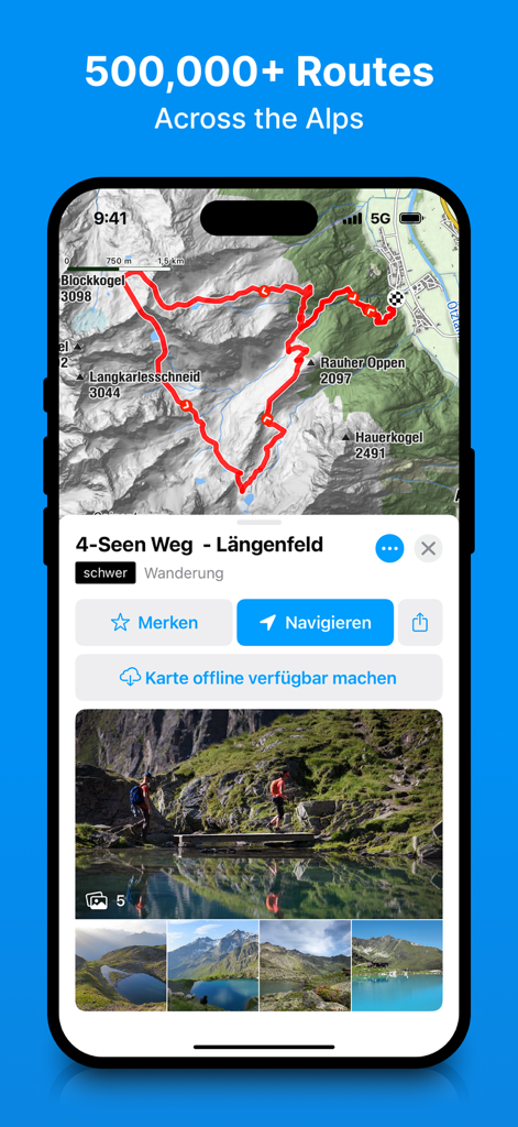
bergfex 앱에서 상세한 하이킹 경로와 지형 지도를 보여주는 스마트폰 화면
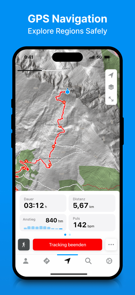
bergfex 앱에 지형 지도와 하이킹 경로, 실시간 추적 통계가 표시되어 있습니다
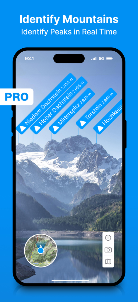
증강 현실 레이블을 사용하여 실시간으로 산봉우리를 식별하는 bergfex 앱을 보여주는 스마트폰 화면
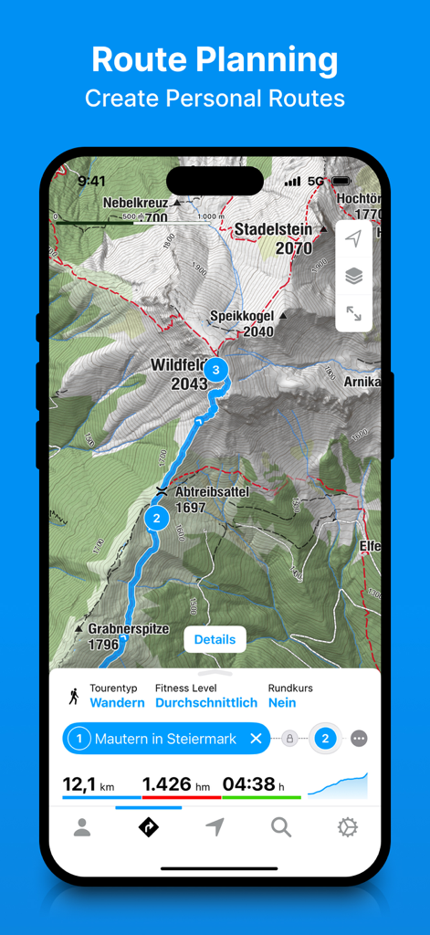
하이킹 통계가 포함된 상세한 지형 산악 지도에서 경로 계획을 보여주는 Bergfex 앱 인터페이스
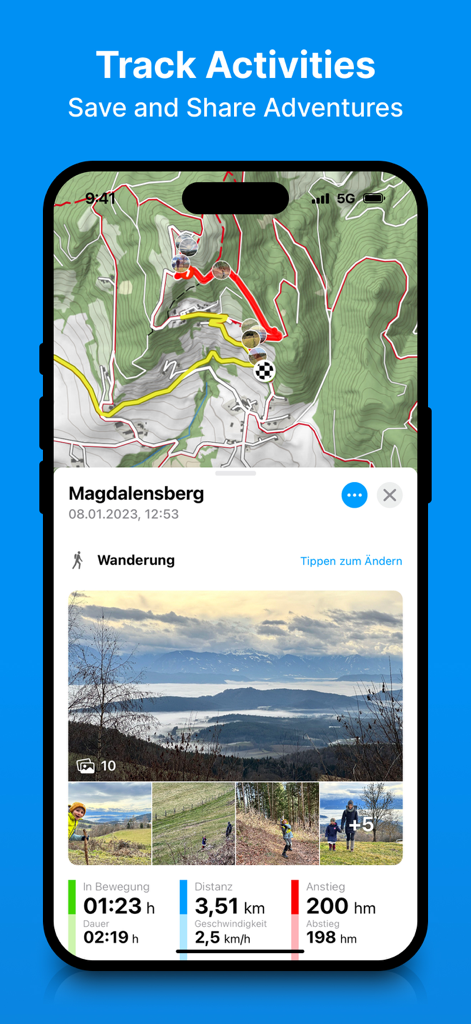
통합된 사진 및 퍼포먼스 통계가 포함된 지형 지도에 추적된 하이킹 경로를 보여주는 Bergfex 앱
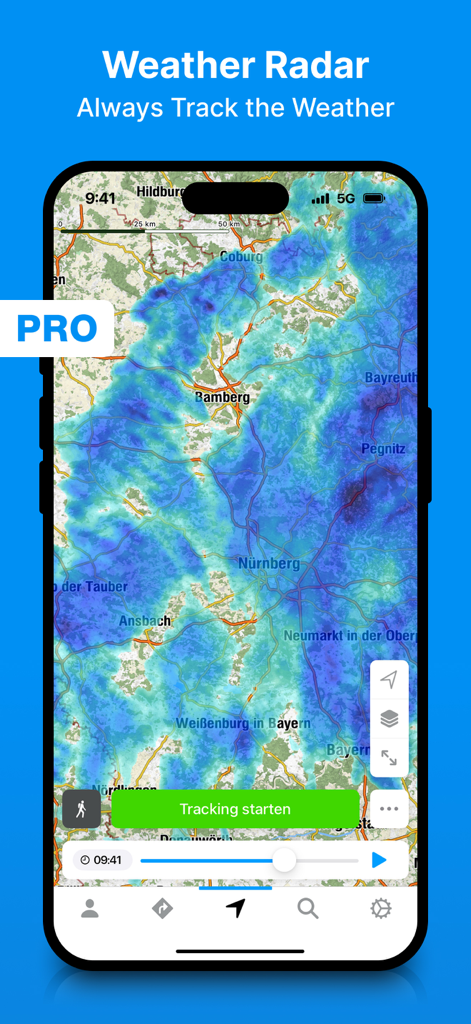
비 추적 오버레이가 있는 bergfex 하이킹 앱 날씨 레이더 인터페이스
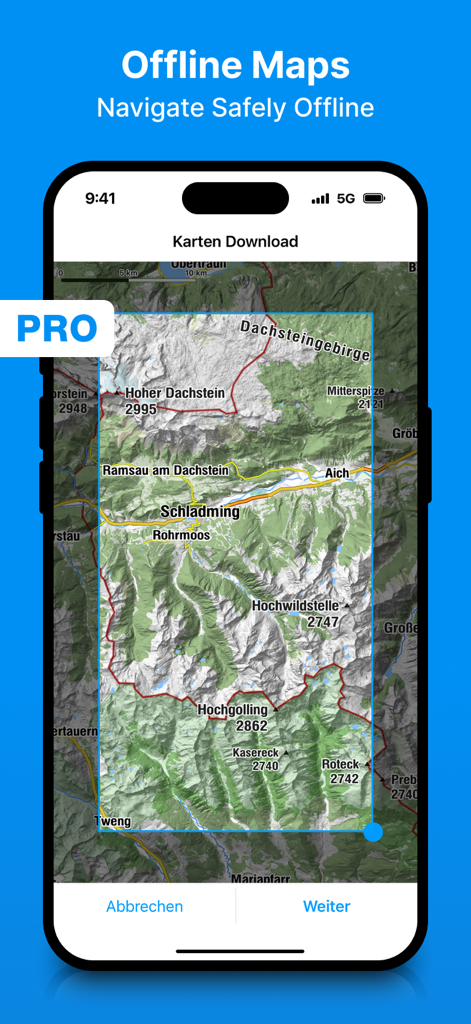
bergfex 앱에서 오프라인 지형 지도 다운로드를 위한 선택 화면
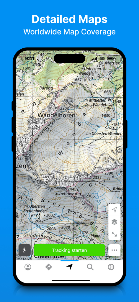
bergfex 하이킹 및 추적 앱에서 상세한 지형 지도 표시
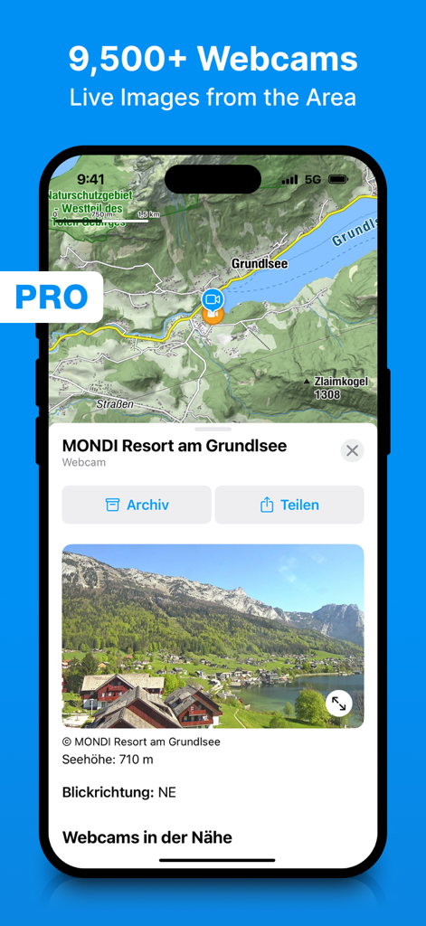
야외 여행 계획을 위한 실시간 웹캠 이미지와 지형 지도 인터페이스를 보여주는 bergfex 하이킹 앱 스크린샷
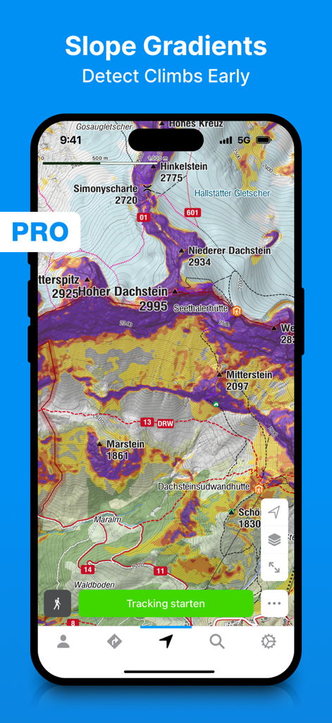
하이커와 스키어를 위한 지형 지도에 경사도 오버레이를 표시하는 Bergfex 앱
설명
Download
비슷한 앱
유사한 기능과 사용자 경험을 가진 앱

AllTrails: Hike, Bike & Run
AllTrails, Inc.

Pedometer++
Cross Forward Consulting, LLC

Organic Maps: Offline Map
Organic Maps OU

Gaia GPS: Mobile Trail Maps
Trailbehind, INC.

Offline hiking maps: Mapy.com
Seznam.cz a.s.

Hiking Map Poland
Mapa Turystyczna sp. z o.o.

MapOut
Valnova GmbH

FarOut: Offline GPS Trail Maps
Atlas Guides DE, Inc.

Norgeskart
Norgeskart AS
이 페이지는 앱이나 개발자의 공식 페이지가 아니며, 정보 제공 및 논평을 목적으로 작성된 독립 편집 간행물입니다. 명시적으로 달리 언급되지 않는 한, 해당 앱이나 개발자는 MWM, Apple, Google Play, 앱 퍼블리셔 또는 앱 개발자와 제휴, 보증, 후원, 승인 또는 공식적으로 연결되어 있지 않으며, 이 페이지의 어떤 내용도 해당 앱이 MWM의 서비스를 사용하여 개발되었음을 의미하지 않습니다. 모든 상표, 로고, 스크린샷 및 기타 콘텐츠는 해당 소유자의 자산입니다.