이 페이지는 앱이나 개발자의 공식 페이지가 아니며, 정보 제공 및 논평을 목적으로 작성된 독립 편집 간행물입니다. 명시적으로 달리 언급되지 않는 한, 해당 앱이나 개발자는 MWM, Apple, Google Play, 앱 퍼블리셔 또는 앱 개발자와 제휴, 보증, 후원, 승인 또는 공식적으로 연결되어 있지 않으며, 이 페이지의 어떤 내용도 해당 앱이 MWM의 서비스를 사용하여 개발되었음을 의미하지 않습니다. 모든 상표, 로고, 스크린샷 및 기타 콘텐츠는 해당 소유자의 자산입니다.

FishAngler - Fish Finder App
전문적인 Garmin Navionics 차트, AI 어종 식별, 실시간 예보를 활용하여 모든 낚시 여행을 성공으로 이끄는 100만 명 이상의 낚시꾼들과 함께하세요.
다운로드
1M+사용자 평점
총 평가 수
18K+개발사
카테고리
Sports지원 언어
32최신 버전
4.6.6크기
304.1 MB출시일
2016년 7월 11일현대 낚시꾼을 위한 정밀 도구
추측은 멈추고 낚시를 시작하세요. 전문가급 지도, 실시간 예보 및 AI 기반 통찰력을 결합하여 어떤 수역이든 정복해 보세요.
전문가급 지도 및 예보
Garmin Navionics 수심 차트로 항해하고 실시간 조석, 바람, 월상을 추적하여 정밀하게 출조 시간을 계획하세요.
비공개 로그북 및 웨이포인트
개인 조과 데이터베이스를 구축하고 완벽한 개인정보 보호 제어를 통해 좋아하는 지점을 표시하세요. 여러분의 '비밀 명소'는 항상 비밀로 유지됩니다.
자주 묻는 질문
에 대해 알아야 할 모든 것 FishAngler - Fish Finder App
FishAngler 앱은 무엇인가요?
FishAngler는 강력한 낚시 지도, 예측, 커뮤니티 도구를 제공하는 포괄적인 낚시 앱입니다. 앵글러가 다양한 종류의 농어, 송어, 바다 물고기 등을 잡을 수 있는 장소를 발견하고, 여행을 계획하고, 조과를 기록하는 데 도움을 줍니다.
FishAngler 앱에서 낚시 지도를 제공하나요?
네, FishAngler 앱은 수백만 개의 검증된 조과 위치, 보트 램프, 암초, 수중 구조물을 보여주는 낚시 지도를 제공합니다. 사용자는 이 지도에 개인적인 경유지를 표시하고 관리할 수도 있습니다.
FishAngler로 낚시 조건을 추적할 수 있나요?
네, FishAngler는 조수, 바람, 달의 위상, 기압, 시간별 물고기 활동을 포함한 포괄적인 낚시 예측을 제공합니다. 이를 통해 사용자는 실시간 조건에 따라 효과적으로 여행을 계획할 수 있습니다.
FishAngler에 조과 기록장이 있나요?
네, FishAngler 앱에는 어종, 장비, 날씨, 개인 통계와 같은 세부 정보를 기록할 수 있는 개인 조과 기록장이 포함되어 있습니다. 이는 앵글러가 패턴을 분석하고 낚시 결과를 개선하는 데 도움이 됩니다.
FishAngler 앱은 물고기 종류를 식별하는 데 어떻게 도움이 되나요?
FishAngler 앱에는 독자적인 AI 물고기 식별 도구가 포함되어 있습니다. 이 도구는 300가지 이상의 민물고기와 바닷물고기 종을 즉시 식별하여 앵글러의 물고기 인식을 돕습니다.
FishAngler는 무료 앱인가요?
네, FishAngler 앱은 무료로 다운로드하여 사용할 수 있으며, 핵심 기능은 무료로 제공됩니다. 광고 없는 환경과 더 많은 고급 도구를 이용하려면 선택적으로 VIP 업그레이드를 할 수 있습니다.
FishAngler VIP에서 사용할 수 있는 프리미엄 기능은 무엇인가요?
FishAngler VIP는 정확한 조과 위치, HD 수심 차트, Garmin Navionics의 호수 윤곽, 개인 경유지, 3D 지도, 광고 없는 탐색 기능을 제공합니다. 이러한 기능은 구독자의 낚시 경험을 향상시킵니다.
FishAngler에서 낚시 장소를 비공개로 유지할 수 있나요?
네, FishAngler는 사용자가 좋아하는 낚시 장소를 개인 경유지로 표시하고 관리할 수 있도록 허용합니다. 앱은 이러한 위치에 대한 완전한 개인 정보 보호를 제공하여 개인 장소가 기밀로 유지되도록 합니다.
FishAngler는 미끼 및 루어 추천을 제공하나요?
네, FishAngler는 미끼 및 루어 인사이트를 제공합니다. 이 기능은 사용자가 자신의 위치 근처에서 앵글러들이 잡고 있는 물고기에 현재 효과적인 미끼와 루어를 보여주어 최적의 장비를 선택하는 데 도움을 줍니다.
FishAngler에서 다른 앵글러들과 어떻게 연결할 수 있나요?
FishAngler는 다른 앵글러들과 연결할 수 있는 커뮤니티 기능을 제공합니다. 사용자는 그룹에 가입하고, 챌린지에 참여하고, 새로운 낚시 친구를 만나고, 앱 내에서 직접 낚시 팁을 공유할 수 있습니다.
FishAngler 앱에서 수심 차트를 사용할 수 있나요?
네, FishAngler는 Garmin Navionics 차트와 수심 윤곽을 포함한 HD 수심 및 해도 차트를 제공합니다. 이러한 프리미엄 레이어는 민물과 바닷물에서 사용할 수 있으며 VIP 업그레이드로 이용할 수 있습니다.
FishAngler는 낚시하기 가장 좋은 시간을 알려주나요?
네, FishAngler의 스마트 낚시 예측은 시간별 물고기 활동을 예측합니다. 조수, 바람, 달의 위상과 같은 요소를 결합하여 특정 장소에서 낚시하기 가장 좋은 시간을 나타냅니다.
다음 스크린샷과 설명은 앱의 공식 스토어 목록에서 직접 가져온 것이며 앱 개발자의 자산입니다.
앱 스토어
스크린샷
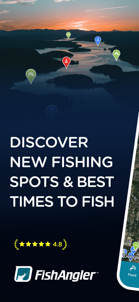
석양이지는 호수의 낚시 지점 마커와 4.8점 별점을 보여주는 FishAngler 앱 스크린샷
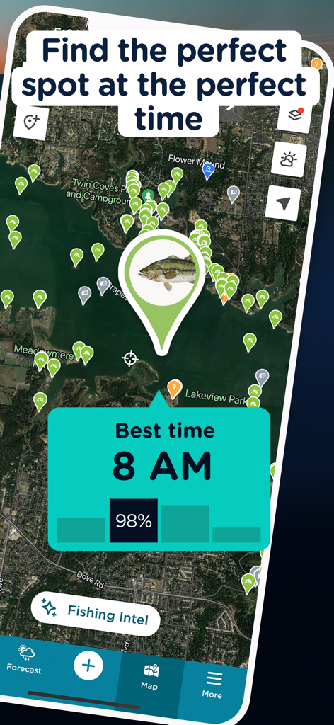
낚시 장소가 표시된 지도와 오전 8시가 낚시하기 가장 좋은 시간임을 나타내는 예보가 있는 FishAngler 앱 화면.
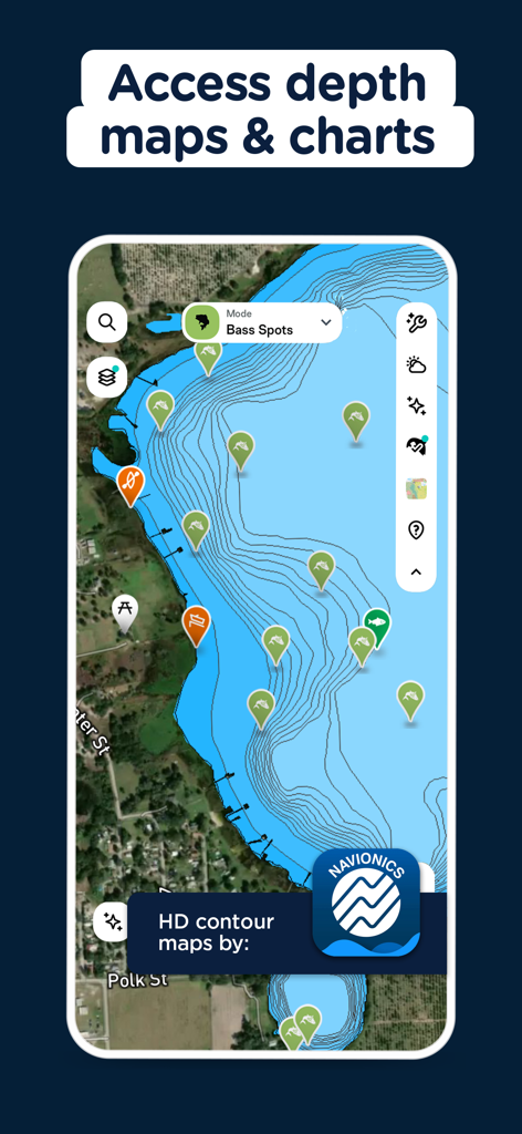
Navionics에서 제공하는 HD 등심선 수심 지도와 낚시 지점 마커를 보여주는 FishAngler 앱 인터페이스
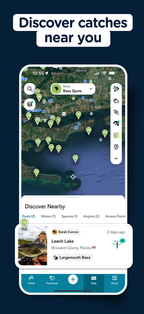
플로리다에서 잡힌 라지마우스 배스에 대한 보고서와 검증된 낚시 조과 위치를 보여주는 FishAngler 앱의 지도 보기
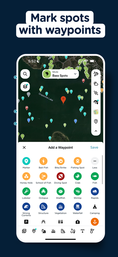
다양한 사용자 지정 웨이포인트 마커와 웨이포인트 추가 메뉴가 있는 위성 낚시 지도를 표시하는 FishAngler 앱 인터페이스.
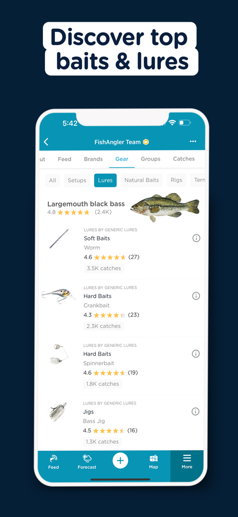
사용자 조과 데이터를 바탕으로 라지마우스 블랙 배스에 가장 높은 평가를 받은 미끼와 루어를 보여주는 FishAngler 앱 화면.
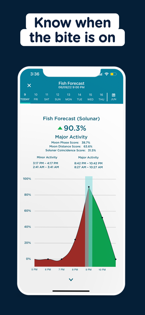
솔루나(solunar) 물고기 활동 예보 및 주요 입질 시간 그래프를 보여주는 FishAngler 앱 인터페이스
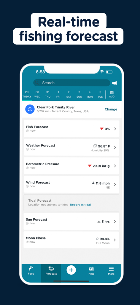
날씨, 바람, 기압 및 월상 데이터를 보여주는 FishAngler 앱 실시간 낚시 예보 화면
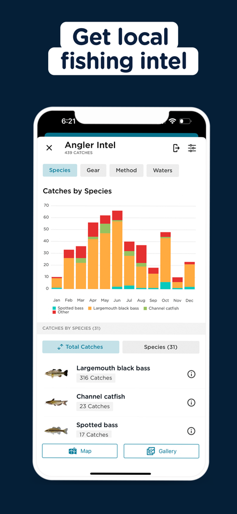
현지 낚시 데이터 및 어종별 조과 통계 차트를 보여주는 FishAngler 앱
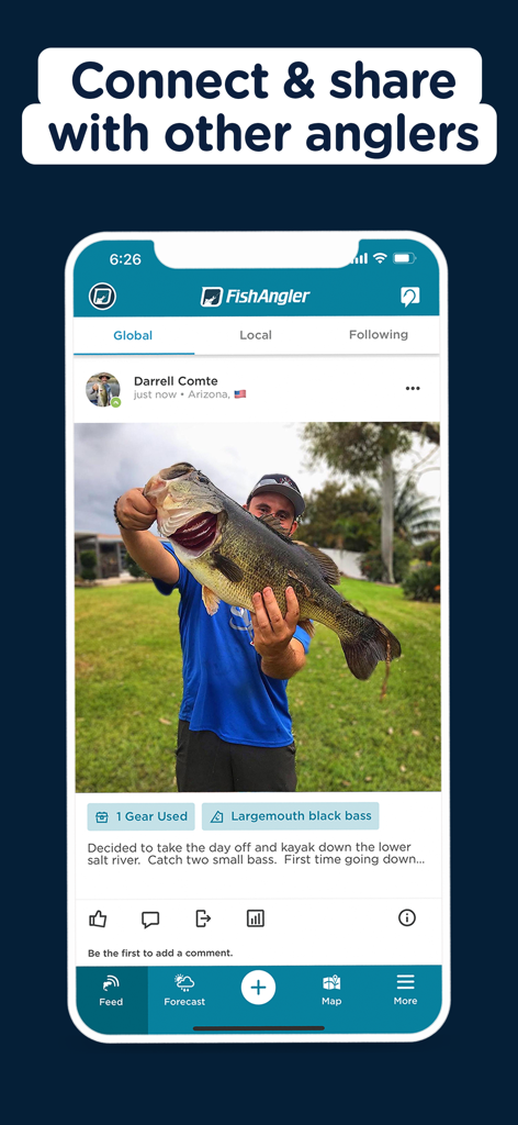
FishAngler 소셜 피드에 라지마우스 배스 조과 사진을 공유하는 낚시꾼.
설명
Download
비슷한 앱
유사한 기능과 사용자 경험을 가진 앱

钓鱼天气预报
Hefei Sasha Technology Co., Ltd.

潮汐表-潮汐天气预报&钓鱼潮汐天气工具助手
荣虎 太

Fishbrain - Fishing App
FishBrain AB

Fishing Points: Map & Forecast
Fishing Points d.o.o.

onX Fish: Midwest Lake Finder
onXmaps, Inc.

Fishbox - Smart Fishing App
MEMS Group, Inc.

釣果記録FishRanker-フィッシュランカー,釣り,分析
SIIG Inc.

Fish Deeper - Fishing App
Deeper UAB

BigBlue Offshore Fishing
GeoPelagic LLC
이 페이지는 앱이나 개발자의 공식 페이지가 아니며, 정보 제공 및 논평을 목적으로 작성된 독립 편집 간행물입니다. 명시적으로 달리 언급되지 않는 한, 해당 앱이나 개발자는 MWM, Apple, Google Play, 앱 퍼블리셔 또는 앱 개발자와 제휴, 보증, 후원, 승인 또는 공식적으로 연결되어 있지 않으며, 이 페이지의 어떤 내용도 해당 앱이 MWM의 서비스를 사용하여 개발되었음을 의미하지 않습니다. 모든 상표, 로고, 스크린샷 및 기타 콘텐츠는 해당 소유자의 자산입니다.