이 페이지는 앱이나 개발자의 공식 페이지가 아니며, 정보 제공 및 논평을 목적으로 작성된 독립 편집 간행물입니다. 명시적으로 달리 언급되지 않는 한, 해당 앱이나 개발자는 MWM, Apple, Google Play, 앱 퍼블리셔 또는 앱 개발자와 제휴, 보증, 후원, 승인 또는 공식적으로 연결되어 있지 않으며, 이 페이지의 어떤 내용도 해당 앱이 MWM의 서비스를 사용하여 개발되었음을 의미하지 않습니다. 모든 상표, 로고, 스크린샷 및 기타 콘텐츠는 해당 소유자의 자산입니다.

Fishing Points: Map & Forecast
1,200만 명의 낚시꾼들과 함께 전문가 수준의 해도를, 솔루너 피딩 타임, 그리고 상세한 날씨 데이터를 이용하여 낚시 계획을 세우고, 항해하며, 더 많은 물고기를 잡으세요.
다운로드
2M+사용자 평점
총 평가 수
66K+개발사
카테고리
Sports지원 언어
11최신 버전
3.1.2크기
217.1 MB출시일
2017년 4월 17일데이터 기반 통찰력으로 물 위를 제패하세요
고해상도 해도에서 정확한 먹이 활동 예측까지, 물고기를 능가하고 모든 낚시 여행을 최적화하는 데 필요한 모든 것을 얻으세요.
정확한 명소 지도
NOAA 해도와 상세한 수심 윤곽선으로 숨겨진 명소를 찾아 완벽한 수중 지형을 공략하세요.
스마트한 먹이 활동 예측
솔루너 주기, 조석, 기압을 추적하여 최대 어획량을 확보하고 최고 활동 시간을 파악하세요.
자주 묻는 질문
에 대해 알아야 할 모든 것 Fishing Points: Map & Forecast
How does Fishing Points help users find the best fishing times?
Fishing Points는 조수, 달 위상, 해양, 솔루너 및 일기 데이터를 분석하여 상세한 낚시 예보를 제공합니다. 시간별 먹이 활동 시간, 일일 물고기 활동, 인기 어종을 위한 최고의 낚시 시간 달력을 제공합니다.
What types of maps are available in the Fishing Points app?
Fishing Points는 상세한 위성 낚시 지도, 전 세계 해도, 오프라인 해양 해도(NOAA)를 포함한 네 가지 유형의 지도를 제공합니다. 또한 해초, 굴 군락, 맹그로브 및 깊이 및 등고선 차트가 있는 호수 지도에 대한 레이어도 특징으로 합니다.
Can I save fishing locations and trolling paths in Fishing Points?
예, Fishing Points를 사용하면 낚시 장소, 위치, 핫스팟 및 웨이포인트를 저장할 수 있습니다. 또한 트롤링 경로 및 트롤라인 녹화를 지원하여 GPS로 저장된 위치를 쉽게 찾을 수 있습니다.
Does Fishing Points provide river data like water levels and flows?
예, Fishing Points는 35,000개 이상의 강 estação에서 현재 수위 및 유량을 제공합니다. 이 기능을 통해 낚시꾼은 강 상태를 모니터링하여 낚시 계획에 정보를 제공할 수 있습니다.
Can users log their catches within the Fishing Points app?
예, Fishing Points에는 개인 포획 로그북이 포함되어 있습니다. 사용자는 사진, 무게, 길이 등 각 포획에 대한 세부 정보를 저장할 수 있으며 날씨, 솔루너 및 조수 정보가 자동으로 추가됩니다.
Does Fishing Points offer offline functionality for its maps?
예, Fishing Points는 NOAA에서 제공하는 해양 해도와 함께 오프라인 모드를 제공합니다. 이 기능을 통해 사용자는 인터넷 연결 없이도 필수 지도 데이터에 액세스할 수 있습니다.
How many anglers use the Fishing Points app worldwide?
Fishing Points는 전 세계 1,200만 명 이상의 낚시꾼을 연결합니다. 이 글로벌 커뮤니티에는 낚시 경험을 향상시키려는 민물 및 바닷물 낚시꾼이 모두 포함됩니다.
Does Fishing Points show tide predictions and marine forecasts?
예, Fishing Points는 고조 및 저조 정보와 함께 시간별 조수 차트를 표시하고 상세한 조류 예측을 제공합니다. 또한 파도, 해수 온도 및 해류에 대한 해양 예보를 제공합니다.
Can I sync my Fishing Points data across multiple devices?
예, Fishing Points를 사용하면 모든 컴퓨터 및 모바일 장치에서 저장된 데이터를 동기화할 수 있습니다. 컴퓨터에서 낚시 여행을 계획하고 분석하기 위한 웹앱도 사용할 수 있습니다.
Does Fishing Points provide a rain radar feature?
예, Fishing Points에는 비 레이더 기능이 포함되어 있습니다. 이를 통해 사용자는 실시간 악천후 경보를 확인하고 지도에서 비 강도를 추적하여 여행 계획을 더 잘 세울 수 있습니다.
다음 스크린샷과 설명은 앱의 공식 스토어 목록에서 직접 가져온 것이며 앱 개발자의 자산입니다.
앱 스토어
스크린샷
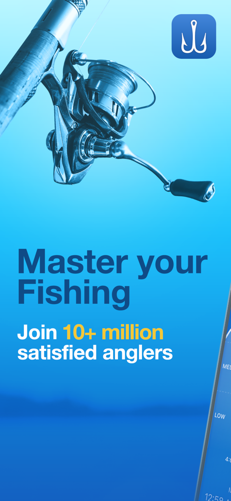
낚시 릴과 'Master your Fishing'이라는 문구가 있는 Fishing Points 앱 홍보 이미지.
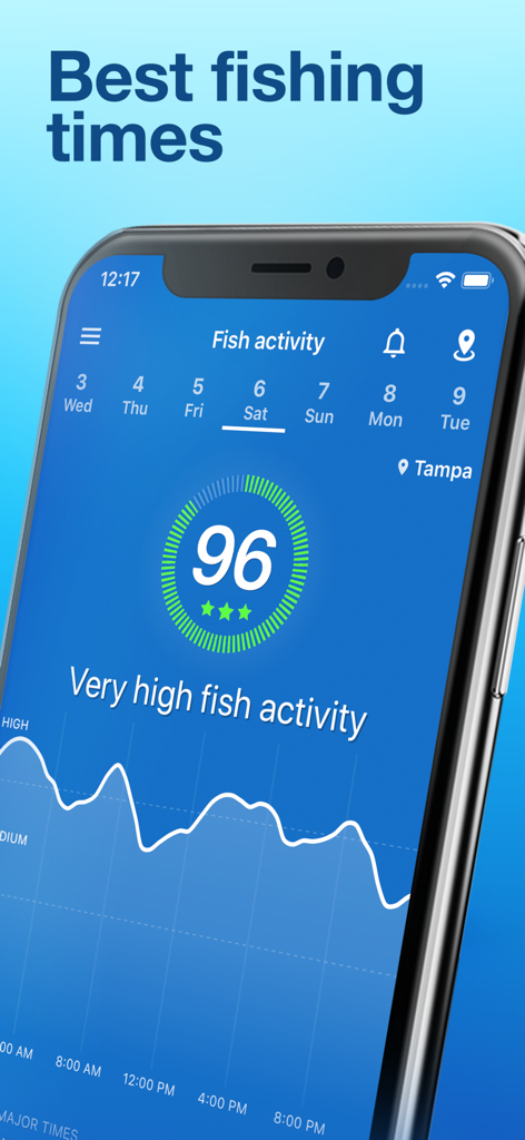
높은 물고기 활동 예측과 최적 낚시 시간 그래프를 보여주는 Fishing Points 앱 인터페이스.
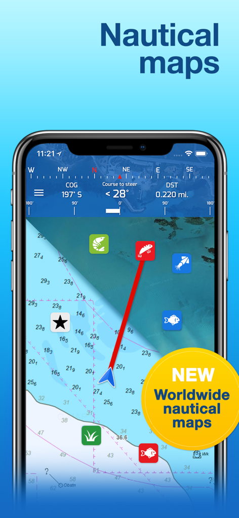
수심 윤곽선과 항해 경유지가 있는 상세한 전 세계 해도를 보여주는 Fishing Points 앱 인터페이스
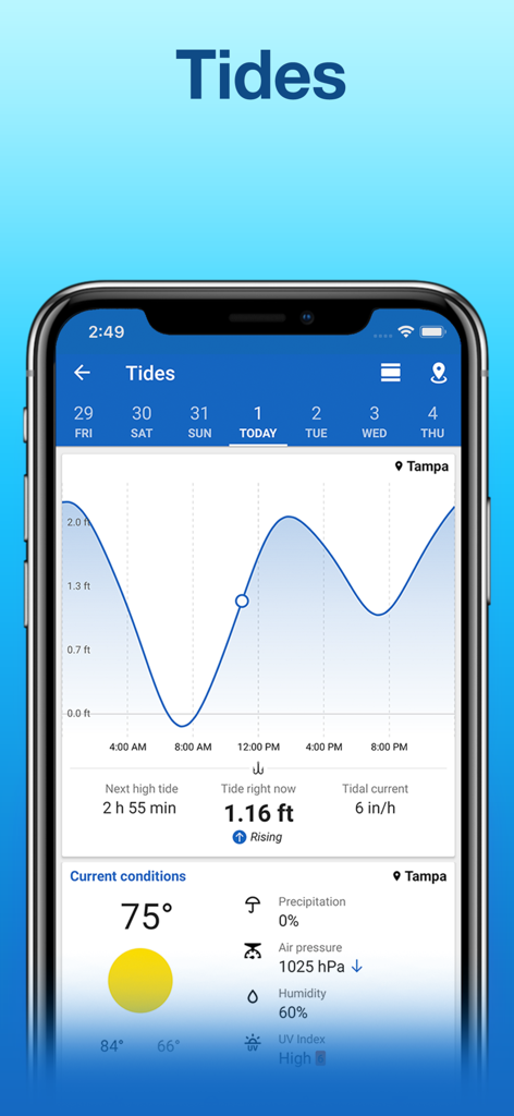
플로리다 탬파의 조석 예측 및 날씨 예보를 보여주는 Fishing Points 앱의 인터페이스
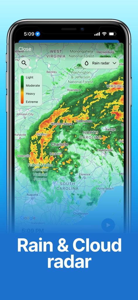
노스캐롤라이나와 사우스캐롤라이나 전역의 실시간 비와 구름 레이더 예보 지도를 보여주는 Fishing Points 앱.
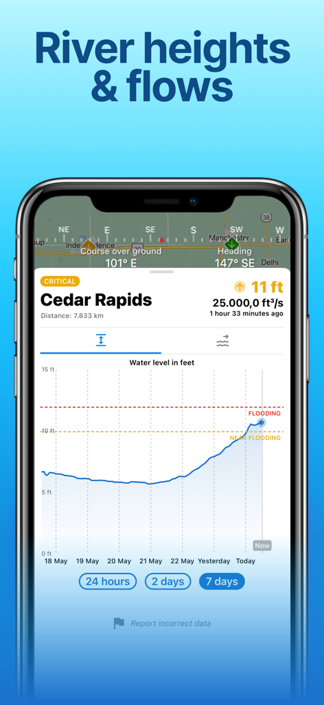
시더 래피즈의 홍수 경고와 함께 강 수위 차트를 보여주는 모바일 앱 화면.
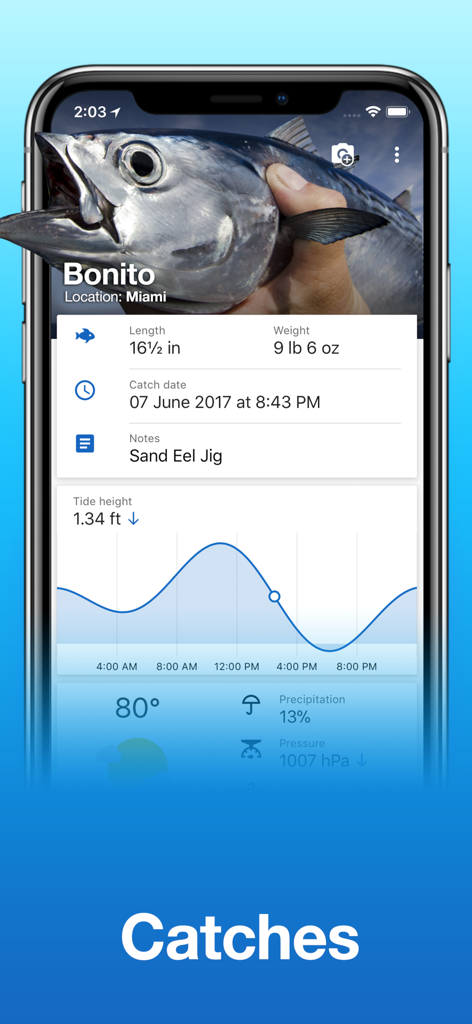
길이, 무게, 조석 높이 그래프 등 상세 정보를 포함한 농어 물고기 낚시 기록을 보여주는 Fishing Points 앱 화면
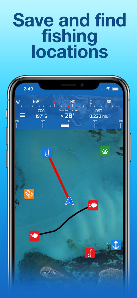
저장된 낚시 장소와 해도 항해 중인 Fishing Points 앱을 보여주는 스마트폰 화면
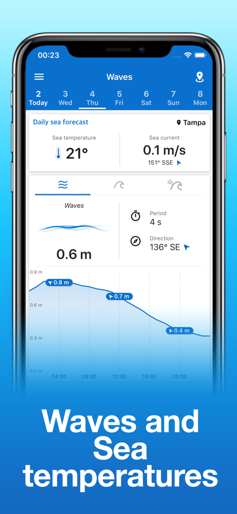
Fishing Points 앱에서 파고와 해수 온도 예보를 보여주는 휴대폰
설명
Download
비슷한 앱
유사한 기능과 사용자 경험을 가진 앱

FishAngler - Fish Finder App
FishAngler, LLC

钓鱼天气预报
Hefei Sasha Technology Co., Ltd.

潮汐表-潮汐天气预报&钓鱼潮汐天气工具助手
荣虎 太

Fishbrain - Fishing App
FishBrain AB

onX Fish: Midwest Lake Finder
onXmaps, Inc.

Fishbox - Smart Fishing App
MEMS Group, Inc.

釣果記録FishRanker-フィッシュランカー,釣り,分析
SIIG Inc.

Fish Deeper - Fishing App
Deeper UAB

BigBlue Offshore Fishing
GeoPelagic LLC
이 페이지는 앱이나 개발자의 공식 페이지가 아니며, 정보 제공 및 논평을 목적으로 작성된 독립 편집 간행물입니다. 명시적으로 달리 언급되지 않는 한, 해당 앱이나 개발자는 MWM, Apple, Google Play, 앱 퍼블리셔 또는 앱 개발자와 제휴, 보증, 후원, 승인 또는 공식적으로 연결되어 있지 않으며, 이 페이지의 어떤 내용도 해당 앱이 MWM의 서비스를 사용하여 개발되었음을 의미하지 않습니다. 모든 상표, 로고, 스크린샷 및 기타 콘텐츠는 해당 소유자의 자산입니다.