이 페이지는 앱이나 개발자의 공식 페이지가 아니며, 정보 제공 및 논평을 목적으로 작성된 독립 편집 간행물입니다. 명시적으로 달리 언급되지 않는 한, 해당 앱이나 개발자는 MWM, Apple, Google Play, 앱 퍼블리셔 또는 앱 개발자와 제휴, 보증, 후원, 승인 또는 공식적으로 연결되어 있지 않으며, 이 페이지의 어떤 내용도 해당 앱이 MWM의 서비스를 사용하여 개발되었음을 의미하지 않습니다. 모든 상표, 로고, 스크린샷 및 기타 콘텐츠는 해당 소유자의 자산입니다.
Flyskyhy
실시간 바람 분석, 사용자 정의 가능한 조종석 디스플레이 및 라이브 추적 기능을 갖춘 강력한 GPS-바리오로 기기를 전환하세요. 고급 열기류 매핑 및 영공 보호 기능으로 더 멀리, 더 안전하게, 더 스마트하게 비행하세요.
주요 수치
다운로드
198K+
사용자 평점
4.4/5
총 평가 수
600
개발사
Rene Dekker
카테고리
Sports
지원 언어
8
최신 버전
9.4
크기
22.6 MB
출시일
2012년 4월 17일
기능
비행 지능을 향상시키세요
패러글라이딩 및 행글라이딩 조종사를 위한 최고 수준의 도구입니다. 안전, 성능 및 커뮤니티를 위해 설계된 고정밀 디지털 조종석으로 아이폰을 전환하세요.
정밀 비행 데이터
실시간 고도, 지면 속도 및 바람 세기에 접근하세요. 직관적인 지도는 열기류를 중심으로 비행하고 착륙 지점까지의 글라이드 도달 거리를 확인하는 데 도움이 됩니다.
영공 안전 및 경유지
30개국 영공 데이터를 사용하여 자신 있게 비행하세요. 제한 구역 근처에서 규정을 준수하고 안전하게 머물 수 있도록 시각 및 청각 경고를 받으세요.
다음 스크린샷과 설명은 앱의 공식 스토어 목록에서 직접 가져온 것이며 앱 개발자의 자산입니다.
앱 스토어
스크린샷
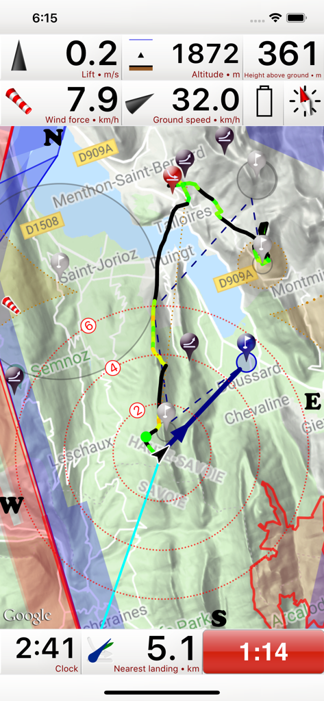
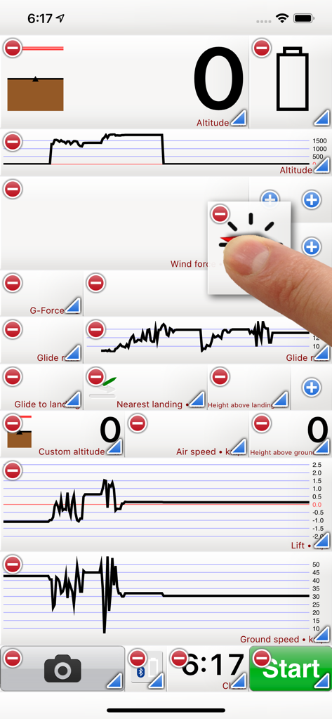
Flyskyhy 앱 비행 계측기 인터페이스, 패러글라이딩을 위한 고도, 지면 속도 및 이동 지도 표시
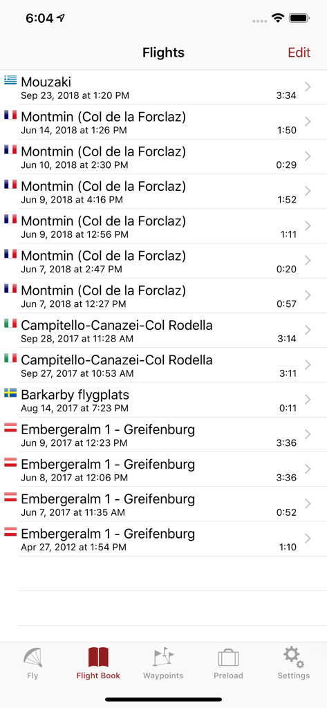
Flyskyhy 앱에서 위치, 날짜 및 비행 시간을 보여주는 기록된 패러글라이딩 비행 목록
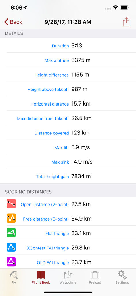
Flyskyhy 앱에 표시된 패러글라이딩을 위한 상세한 비행 기록 통계 및 득점 거리.
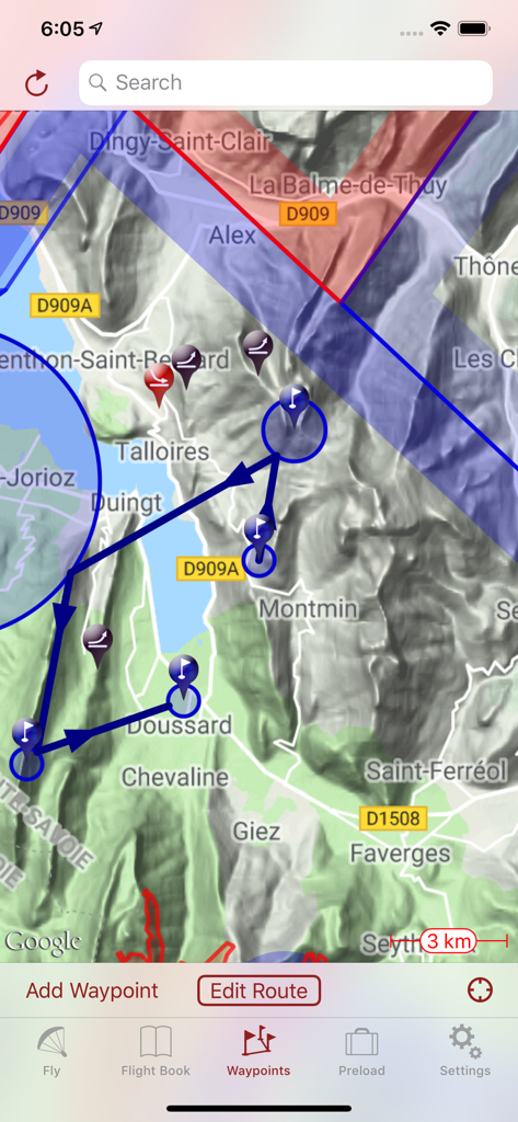
경유지 및 영공이 있는 계획된 비행 경로를 표시하는 Flyskyhy 앱의 지형도
조종사를 위한 사용자 정의 가능한 비행 데이터 위젯 및 차트를 보여주는 Flyskyhy 앱 인터페이스
설명
Flyskyhy forms your flight instrument during flight and shows all information you need for that. You get the normal data like altitude, climb rate, ground speed, and glide angle. But it also calculates and shows the current wind direction and strength, very important for your safety.
A moving and rotating map shows your current flying position and flight trail. It indicates where you have gone up (in a thermal), and where you have had faster than normal decline. With that, you can easily find back that thermal that you lost. The map also shows the nearest known landing spots, and whether they are reachable by normal glide, given your current altitude and wind direction.
Integration with Bluetooth varios SensBox, FlyNet, GoFly iPico, XC-Tracer, BlueFlyVario, or SkyDrop gives accurate altitude and lift information. That turns your iPhone into an full-fletched GPS-vario, including vario tones.
The app makes a full log of your flight, that can be analyzed afterwards. Besides normal data like start and landing positions, duration of flight, and an altitude graph of the flight, Flyskyhy also calculates the scoring distances for you. So you can immediately see whether you have broken that FAI triangle record.
Your live location is reported on livetrack24.com or loctome.com if you desire, so anybody can follow your flight while it is happening. If you are flying together with friends, then their location is shown on your map during your flight. So you never have to wonder anymore whether they are in front of or behind you.
The flight display has multiple screens which are all fully configurable. You can move all elements to other spots, delete and add elements, and resize them.
Through in-app purchases, the app also supports airspaces and waypoints.
The app is optimised for paragliding and hang gliders, but can be used with all kinds of airsports.
Main features during the flight;
• Altitude, climb rate, ground speed, air speed, direction, glide angle and many more
• Wind strength and direction
• Moving map of the flying area
• Spots where you have had lift, great for thermal coring
• Shows whether you can still reach a landing spot with the current altitude and wind
• Live tracking of your flight on livetrack24.com or loctome.com
• Shows live location of your friends during flight
After the flight:
• Full logbook of all your flights
• Basic flight data like start/landing, duration, height difference, distance flown, and many more
• Calculation of 5-points, open triangle, and FAI triangle distances
• Graph of altitude and climb rate
• Signed IGC and KML log files of flights
• Transfer the log to iTunes or send by email
• Upload the flight directly to XContest, ParaglidingForum, DHV-XC, and other Leonardo servers
• Open flight in Google Earth on the iPhone
• Replay the flight and relive it!
By purchasing the Waypoints Extension you get access to:
• A fully zoomable and scrollable map with the waypoints and optimised route. The map also shows start and landing spots, as well as restricted airspaces (with the Airspace Extension)
• Enter new waypoints, either on the map or by specifying the parameters
• Full route support with start time, goal, entry/exit points, etc.
• Many instruments to guide you along the route
• Visible and audible indication when a waypoint has been reached
• Complete waypoints organiser
• Import and export of various waypoint file formats
By purchasing the Airspace Extension you get access to:
• Airspaces of 30 countries
• Display of airspaces on the map with configurable colors and formats
• Display of your vertical position w.r.t. airspaces
• Visible and audible warnings when approaching and entering an airspace
• Shows local airspaces by touching a spot on the map
Note: a live internet connection is required for live tracking of your and your friends locations
Note: continuous GPS and screen usage makes the battery drain faster than normal
이 페이지는 앱이나 개발자의 공식 페이지가 아니며, 정보 제공 및 논평을 목적으로 작성된 독립 편집 간행물입니다. 명시적으로 달리 언급되지 않는 한, 해당 앱이나 개발자는 MWM, Apple, Google Play, 앱 퍼블리셔 또는 앱 개발자와 제휴, 보증, 후원, 승인 또는 공식적으로 연결되어 있지 않으며, 이 페이지의 어떤 내용도 해당 앱이 MWM의 서비스를 사용하여 개발되었음을 의미하지 않습니다. 모든 상표, 로고, 스크린샷 및 기타 콘텐츠는 해당 소유자의 자산입니다.