이 페이지는 앱이나 개발자의 공식 페이지가 아니며, 정보 제공 및 논평을 목적으로 작성된 독립 편집 간행물입니다. 명시적으로 달리 언급되지 않는 한, 해당 앱이나 개발자는 MWM, Apple, Google Play, 앱 퍼블리셔 또는 앱 개발자와 제휴, 보증, 후원, 승인 또는 공식적으로 연결되어 있지 않으며, 이 페이지의 어떤 내용도 해당 앱이 MWM의 서비스를 사용하여 개발되었음을 의미하지 않습니다. 모든 상표, 로고, 스크린샷 및 기타 콘텐츠는 해당 소유자의 자산입니다.

Relief Maps : backcountry gps
PCT부터 로키 산맥까지, 전문가 수준의 오프라인 USGS 지도, 눈사태 경사 분석, 스키 투어링, 등산, 패러글라이딩을 위한 특수 도구로 모든 봉우리를 정복하세요.
다운로드
106K+사용자 평점
총 평가 수
900개발사
카테고리
Navigation지원 언어
2최신 버전
2.5.1크기
196.9 MB출시일
2019년 1월 20일기술적인 탐험가를 위해 설계됨
PCT 종주를 계획하든, 위험도가 높은 스키 투어를 계획하든, Relief Maps는 한계를 안전하게 넓힐 수 있도록 3D 데이터와 오프라인 신뢰성을 제공합니다.
몰입형 3D 지형 분석
고화질 3D 렌더링된 USGS 지형도를 통해 경로를 시각화하여 트레일에 발을 딛기 전에 정확한 지형을 파악하세요.
임무 수행에 필수적인 오프라인 지도
광활한 야생에서 사용할 수 있도록 무제한의 지도 레이어를 다운로드하세요. 셀룰러 서비스나 데이터 없이도 완벽하게 작동하는 GPS 내비게이션으로 길을 잃지 마세요.
다음 스크린샷과 설명은 앱의 공식 스토어 목록에서 직접 가져온 것이며 앱 개발자의 자산입니다.
앱 스토어
스크린샷
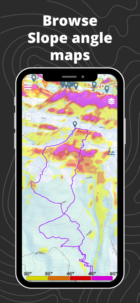
Relief Maps 모바일 앱에서 백컨트리 안전을 위한 추적된 GPS 경로가 있는 3D 경사 각도 지도를 보여줍니다.
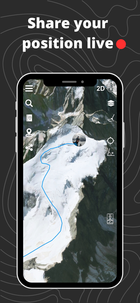
Relief Maps 앱 인터페이스에서 파란색 경로와 실시간 위치 표시기가 있는 3D 산악 지형을 보여줍니다.
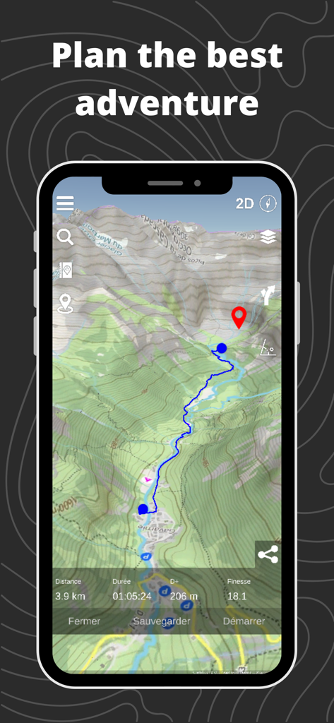
Relief Maps 앱에서 3D 지형 지도와 계획된 백컨트리 경로를 보여줍니다.
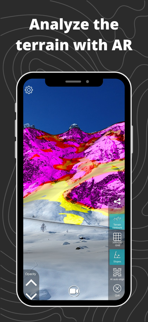
백컨트리 내비게이션을 위한 산 경사도에 대한 증강 현실 보기.
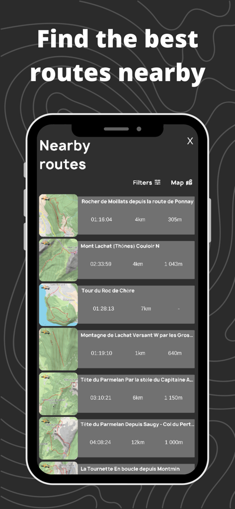
Relief Maps 앱 인터페이스에서 기술 데이터와 지형도 썸네일이 있는 주변 백컨트리 경로 목록을 표시합니다.
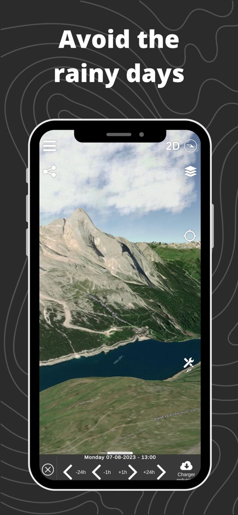
스마트폰의 3D 지형 산악 지도에 날씨 예보 타임라인을 표시하여 백컨트리 여행 중 비오는 날을 피합니다.
설명
Download
비슷한 앱
유사한 기능과 사용자 경험을 가진 앱

Saki - Connect & Share
潇泳 庄

Gaggle Paragliding, Ultralight
Viszen Pty Ltd

AvTraffic
Tailwind Software

Paragliding Tracker: Wingman
iSolid SPRL

Skida: Alpine Adventures
Mountainsnow AS

RealityMaps 3D tour planner
3D RealityMaps GmbH

Spot Assist Skydiving Tool
Andrey Kan

Flyskyhy
Rene Dekker

iGlide Advanced
Logic Design
이 페이지는 앱이나 개발자의 공식 페이지가 아니며, 정보 제공 및 논평을 목적으로 작성된 독립 편집 간행물입니다. 명시적으로 달리 언급되지 않는 한, 해당 앱이나 개발자는 MWM, Apple, Google Play, 앱 퍼블리셔 또는 앱 개발자와 제휴, 보증, 후원, 승인 또는 공식적으로 연결되어 있지 않으며, 이 페이지의 어떤 내용도 해당 앱이 MWM의 서비스를 사용하여 개발되었음을 의미하지 않습니다. 모든 상표, 로고, 스크린샷 및 기타 콘텐츠는 해당 소유자의 자산입니다.