이 페이지는 앱이나 개발자의 공식 페이지가 아니며, 정보 제공 및 논평을 목적으로 작성된 독립 편집 간행물입니다. 명시적으로 달리 언급되지 않는 한, 해당 앱이나 개발자는 MWM, Apple, Google Play, 앱 퍼블리셔 또는 앱 개발자와 제휴, 보증, 후원, 승인 또는 공식적으로 연결되어 있지 않으며, 이 페이지의 어떤 내용도 해당 앱이 MWM의 서비스를 사용하여 개발되었음을 의미하지 않습니다. 모든 상표, 로고, 스크린샷 및 기타 콘텐츠는 해당 소유자의 자산입니다.
RealityMaps 3D tour planner
고해상도 항공 매핑과 전문가 검증 경로로 다음 모험을 시각화하세요. 현재 사용 가능한 가장 정확한 3D 지형 데이터를 사용하여 정밀하게 기술적인 하이킹, 자전거 트레일 및 스키 투어를 계획하세요.
주요 수치
다운로드
135K+
사용자 평점
4.5/5
총 평가 수
1K+
개발사
3D RealityMaps GmbH
카테고리
Navigation
지원 언어
2
최신 버전
2.0.61
크기
112.8 MB
출시일
2013년 7월 18일
기능
비교할 수 없는 3D 선명도로 탐색하세요
첨단 스카우팅부터 실시간 백컨트리 안전까지, 절대적인 자신감으로 기술적인 지형을 정복하는 데 필요한 정밀 도구를 얻으세요.
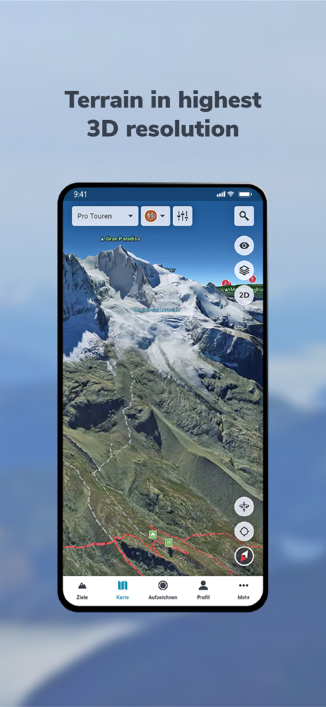
몰입형 3D 계획
항공 등급의 정확도로 모든 능선, 절벽, 트레일을 시각화하세요. 첫 발을 내딛기 전에 지형을 마스터하기 위해 사실적인 3D 환경에서 경로를 스카우팅하세요.
기술적 지형 인텔리전스
경사도와 방향을 즉시 평가하세요. 백컨트리 안전에 필수적이며 잠재적 위험을 식별하고 전문가처럼 복잡한 봉우리를 탐색하는 데 도움이 됩니다.
다음 스크린샷과 설명은 앱의 공식 스토어 목록에서 직접 가져온 것이며 앱 개발자의 자산입니다.
앱 스토어
스크린샷
스마트폰에 표시된 그란 파라디소 산의 고해상도 3D 지형 지도
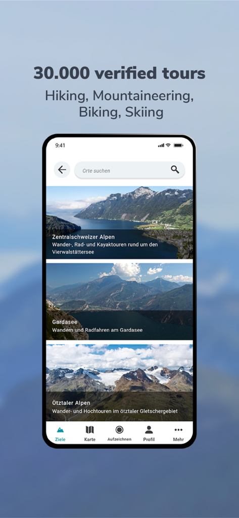
알프스의 검증된 하이킹 및 등산 투어 목록을 보여주는 RealityMaps 3D 앱이 표시된 스마트폰 화면
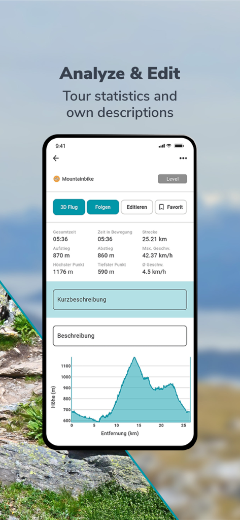
산악 자전거 투어 통계 및 고도 프로필 그래프를 보여주는 RealityMaps 3D 앱 인터페이스.
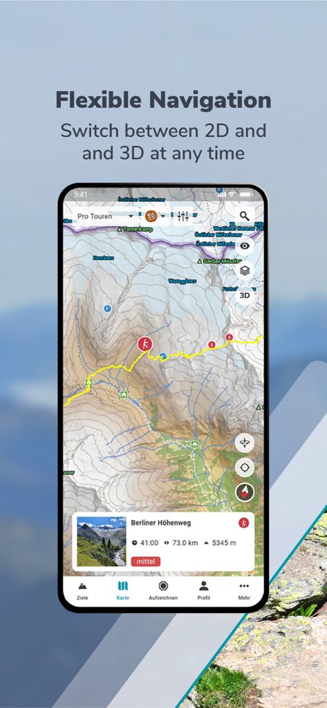
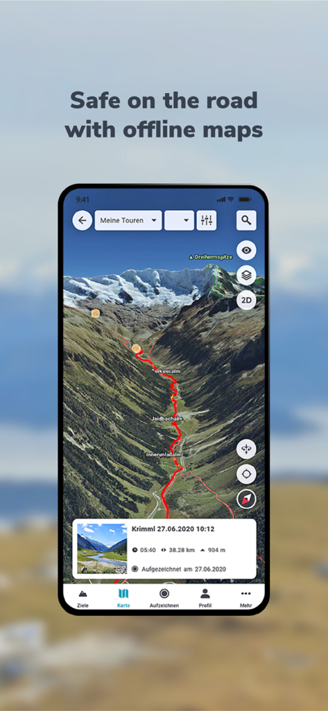
사실적인 3D 산악 풍경에 빨간색 하이킹 경로를 표시하는 RealityMaps 3D 앱
눈 덮인 산봉우리의 스키 경로를 보여주는 고해상도 3D 겨울 지도
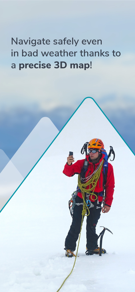
안전을 위해 눈 덮인 봉우리에서 3D 내비게이션을 사용하는 산악 등반가
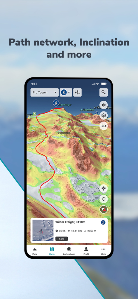
색상으로 구분된 경사도와 지형 디테일이 있는 산악 경로를 보여주는 RealityMaps 3D 인터페이스
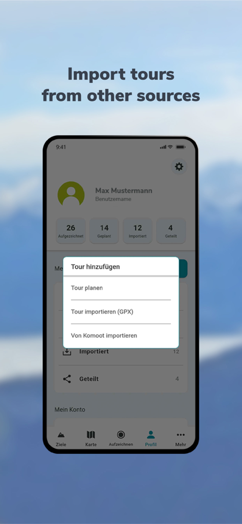
GPX 파일 또는 Komoot에서 하이킹 및 자전거 투어를 가져오는 메뉴를 보여주는 RealityMaps 3D용 모바일 인터페이스.
설명
RealityMaps Hiking Bike MTB
Best 3D map for challenging outdoor experiences, 3D route planner & tracking
Are you ready for unique outdoor experiences and exciting new places? The RealityMaps app is your perfect companion for challenging adventures – with the most accurate 3D map of all apps.
We create our realistic 3D map from aerial and satellite images using innovative technology. This allows you to accurately assess the terrain and plan your tour with confidence.
Be inspired by over 30,000 verified tours for hiking, biking, mountaineering, or skiing – in Europe's most beautiful mountain regions. Or plan your own routes directly in the 3D map, even off the beaten track.
Additional map information on hiking and biking trails, as well as slope gradient and orientation, will help you with your planning. The app also offers GPS tracking, GPX import, offline maps, and access to more than 5,000 webcams showing current conditions.
VERIFIED TOUR VARIETY
The app offers exclusively hiking, mountain, ski, and bike tours from Bergverlag Rother and other partners, thoroughly researched by experts. With the GPS, you can easily follow the marked routes of the tours.
DETAILED MAP MATERIAL
A topographical map in 2D and 3D complements the 3D map. Additional map layers provide information on hiking and cycling trails, as well as slope gradients and slope orientation.
GREATER SAFETY
The app offers the highest level of safety. The 3D map allows you to see the steepness and condition of the terrain and identify potential hazards. The resolution of the 3D map is so good that you can orient yourself even in bad weather, in fog, or at night.
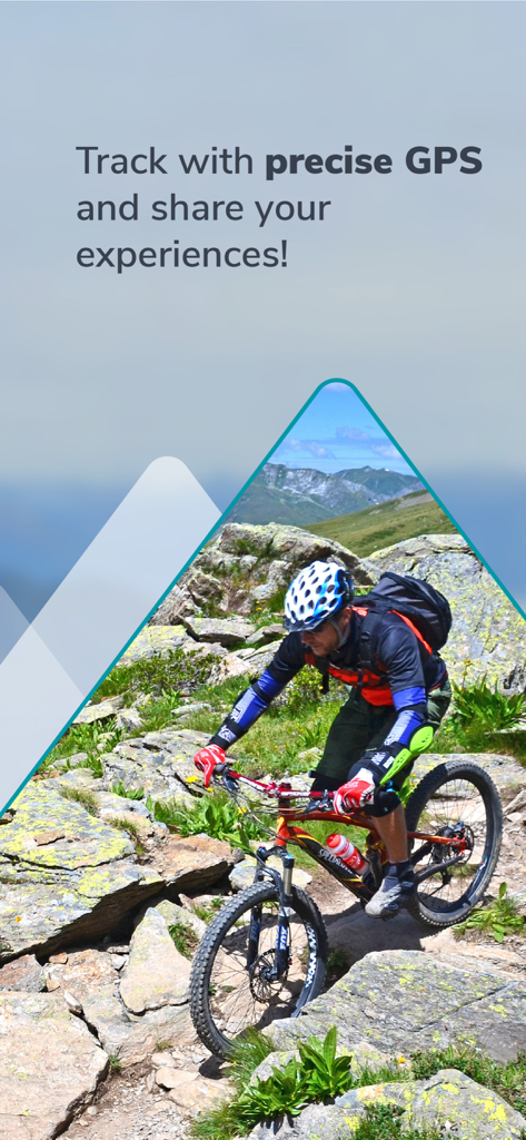
GPS TRACKING
GPS tracking transforms your smartphone into a fully-fledged navigation device. While on tour, your current location is always displayed live on the 3D map.
PLANNING TOURS
With the routing function, you can plan your own routes directly on the 3D map or the topographic map. You can plan routes along existing paths or a route through pathless terrain to discover unique places.
RECORD AND SHARE YOUR TOURS
With GPS tracking, you can record tours and view the route you've taken live on the 3D map. Duration, distance, elevation, and speed are continuously recorded. Create your personal user account to save the recorded tracks, transfer your tracks to other smartphones or tablets, and share them with friends.
IMPORTING TOURS AS GPX
For unlimited tour variety, you can import tours in GPX format or from Komoot into the 3D map. This puts the entire world of hiking, biking, and mountain tours from the internet at your fingertips.
MAPS FOR SUMMER & WINTER
Global coverage with satellite images. High-resolution 3D map for the entire Alps and Pyrenees (summer & winter), as well as for other selected mountain regions in Europe (summer only).
OFFLINE MAPS
Important for your safety: download selected regions of the 3D map on your smartphone for use without an internet connection.
Try PRO features free for 7 days with no obligation.
Register and try all PRO features free for one week.
- Detailed tour descriptions
- Unlimited tour recording, saving, sharing, and transferring to other devices
- All map layers (2D and 3D, aerial photography and topographic maps, hiking and cycling trails, slope gradient and slope orientation)
- Save the 3D map to your smartphone for offline use
- Plan tours in 3D
- Automatically synchronize self-recorded, planned, and imported tours between the app and the web tour planner
이 페이지는 앱이나 개발자의 공식 페이지가 아니며, 정보 제공 및 논평을 목적으로 작성된 독립 편집 간행물입니다. 명시적으로 달리 언급되지 않는 한, 해당 앱이나 개발자는 MWM, Apple, Google Play, 앱 퍼블리셔 또는 앱 개발자와 제휴, 보증, 후원, 승인 또는 공식적으로 연결되어 있지 않으며, 이 페이지의 어떤 내용도 해당 앱이 MWM의 서비스를 사용하여 개발되었음을 의미하지 않습니다. 모든 상표, 로고, 스크린샷 및 기타 콘텐츠는 해당 소유자의 자산입니다.