이 페이지는 앱이나 개발자의 공식 페이지가 아니며, 정보 제공 및 논평을 목적으로 작성된 독립 편집 간행물입니다. 명시적으로 달리 언급되지 않는 한, 해당 앱이나 개발자는 MWM, Apple, Google Play, 앱 퍼블리셔 또는 앱 개발자와 제휴, 보증, 후원, 승인 또는 공식적으로 연결되어 있지 않으며, 이 페이지의 어떤 내용도 해당 앱이 MWM의 서비스를 사용하여 개발되었음을 의미하지 않습니다. 모든 상표, 로고, 스크린샷 및 기타 콘텐츠는 해당 소유자의 자산입니다.

다운로드
2.5M+사용자 평점
총 평가 수
2.3K개발사
카테고리
Navigation지원 언어
36최신 버전
4.13크기
424.9 MB출시일
2018년 10월 15일경험이 풍부한 아웃도어 활동가와 전문가를 위한 Garmin Explore™ 앱의 핵심 기능을 평가합니다.
Garmin Explore™ 앱 분석: 아웃도어 모험을 위한 필수 도구
오프그리드 내비게이션
호환 가능한 가민 기기와 연동 시, 이 앱은 Wi-Fi나 셀룰러 서비스 없이도 모바일 기기를 통해 야외 내비게이션, 여행 계획 수립 및 지도 기능을 사용할 수 있게 해줍니다.
LiveTrack™ 실시간 위치 추적
LiveTrack™ 기능을 활용하여, 사랑하는 사람들이 사용자의 실시간 위치를 추적하고 이동 거리, 시간, 고도와 같은 데이터를 확인할 수 있어 야외 활동 시 안전을 강화합니다.
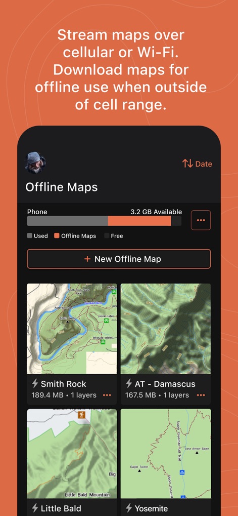
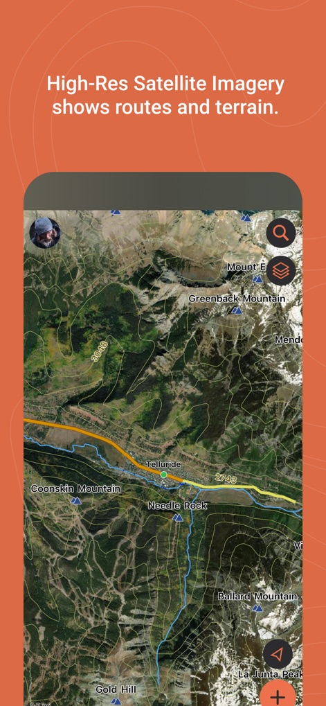
스트리밍 및 오프라인 지도 다운로드
이 앱은 여행 전 Wi-Fi 또는 셀룰러 범위 내에서 지도를 스트리밍하거나, 셀룰러 서비스 범위를 벗어날 경우를 대비하여 오프라인 사용을 위한 지도를 미리 다운로드할 수 있게 해줍니다.
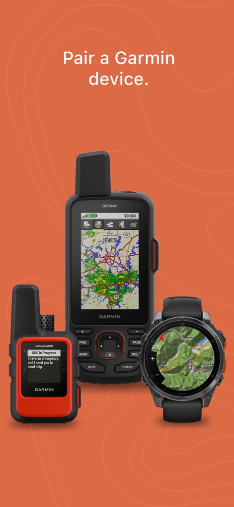
가민 기기와의 연동 및 데이터 동기화
이 도구는 사용자의 스마트폰이나 태블릿을 호환 가능한 가민 기기와 연동하여, 오프그리드 모험을 위한 데이터(웨이포인트, 경로 등)를 원활하게 동기화하고 공유할 수 있도록 합니다.
무제한 지도 다운로드 및 다양한 지도 접근
이 앱은 지형도, USGS 쿼드 시트 등을 포함한 다양한 종류의 지도를 무제한으로 다운로드할 수 있는 기능을 제공하여 포괄적인 지리 정보에 접근할 수 있도록 합니다.
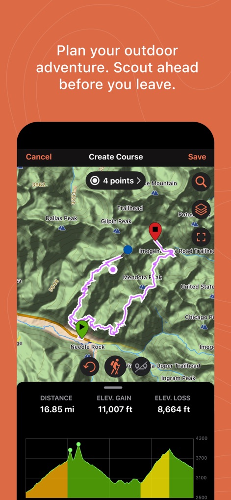
손쉬운 여행 계획 및 경로 생성
이 앱은 지도를 다운로드하고 출발점과 도착점을 지정하여 자동으로 경로를 생성하는 등 다음 여행을 쉽게 계획할 수 있도록 지원하며, 이를 호환되는 가민 기기와 동기화할 수 있습니다.
클라우드 저장소
사용자가 생성한 웨이포인트, 경로, 활동 데이터는 셀룰러 또는 Wi-Fi 범위 내에서 자동으로 가민 익스플로어 웹 계정에 동기화되어 활동 데이터를 안전하게 보존합니다.
고정밀 GPS 여행 기록 및 위치 공유
이 도구는 고정밀 GPS 데이터를 사용하여 사용자의 여행을 상세하게 기록하며, 기록된 위치 데이터를 다른 사람과 공유할 수 있게 합니다.
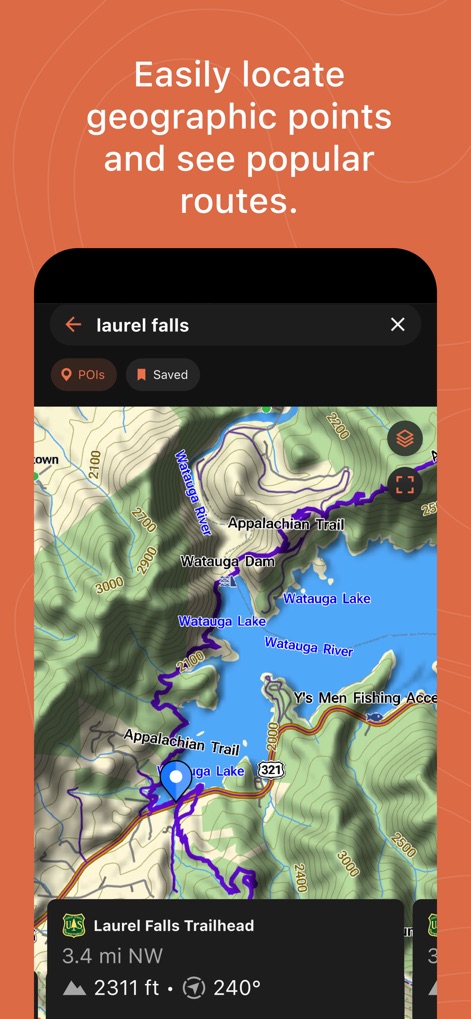
지리적 지점 검색
사용자가 트레일 입구나 산 정상과 같은 모험과 관련된 지리적 지점을 쉽게 찾을 수 있도록 돕는 검색 기능을 제공합니다.
활동 라이브러리 및 컬렉션
저장된 웨이포인트, 트랙, 경로 및 활동을 포함한 정리된 데이터를 검토하고 편집할 수 있는 활동 라이브러리를 제공하며, 컬렉션 목록을 통해 특정 여행과 관련된 모든 데이터를 빠르게 찾을 수 있도록 돕습니다.
자주 묻는 질문
에 대해 알아야 할 모든 것 Garmin Explore™
Can Garmin Explore be used for off-grid navigation without Wi-Fi or cellular service?
Yes, the Garmin Explore app enables off-grid navigation with a compatible Garmin device even without Wi-Fi or cellular service. It supports downloading maps for offline use.
What devices are compatible with the Garmin Explore app?
The Garmin Explore app pairs with compatible Garmin devices for outdoor navigation, data sync, and sharing. Specific compatible devices are listed on garmin.com/appcompatibility.
What types of maps are available in Garmin Explore?
Garmin Explore offers unlimited map downloads, including topographic maps, USGS quad sheets, and aerial imagery. Users can stream maps online or download them for offline use.
How does Garmin Explore help with trip planning?
Garmin Explore simplifies trip planning by allowing users to download maps, create courses with specified start/finish points, and sync them with a compatible Garmin device. It also aids scouting.
Does Garmin Explore offer cloud storage for activity data?
Yes, Garmin Explore automatically syncs waypoints, courses, and activities to your Garmin Explore web account when within cellular or Wi-Fi range, providing unlimited cloud storage. A Garmin account is required.
Can others track my location in real time with Garmin Explore?
Yes, the LiveTrack™ feature in Garmin Explore allows loved ones to follow your real-time location, viewing data like distance, time, and elevation, when used with compatible devices.
How can I find geographic points using the Garmin Explore app?
The Garmin Explore app includes a search tool to easily locate geographic points like trailheads or mountain summits. Users can also view popular routes on the map.
How do I review and organize past activities in Garmin Explore?
Users review and organize past activities in Garmin Explore via the Saved tab. This section displays organized data, including waypoints, tracks, courses, and activities, with map thumbnails.
다음 스크린샷과 설명은 앱의 공식 스토어 목록에서 직접 가져온 것이며 앱 개발자의 자산입니다.
앱 스토어
스크린샷

설명
Download
비슷한 앱
유사한 기능과 사용자 경험을 가진 앱

AllTrails: Hike, Bike & Run
AllTrails, Inc.

Pedometer++
Cross Forward Consulting, LLC

Organic Maps: Offline Map
Organic Maps OU

Gaia GPS: Mobile Trail Maps
Trailbehind, INC.

Offline hiking maps: Mapy.com
Seznam.cz a.s.

Hiking Map Poland
Mapa Turystyczna sp. z o.o.

MapOut
Valnova GmbH

FarOut: Offline GPS Trail Maps
Atlas Guides DE, Inc.

Norgeskart
Norgeskart AS
이 페이지는 앱이나 개발자의 공식 페이지가 아니며, 정보 제공 및 논평을 목적으로 작성된 독립 편집 간행물입니다. 명시적으로 달리 언급되지 않는 한, 해당 앱이나 개발자는 MWM, Apple, Google Play, 앱 퍼블리셔 또는 앱 개발자와 제휴, 보증, 후원, 승인 또는 공식적으로 연결되어 있지 않으며, 이 페이지의 어떤 내용도 해당 앱이 MWM의 서비스를 사용하여 개발되었음을 의미하지 않습니다. 모든 상표, 로고, 스크린샷 및 기타 콘텐츠는 해당 소유자의 자산입니다.