이 페이지는 앱이나 개발자의 공식 페이지가 아니며, 정보 제공 및 논평을 목적으로 작성된 독립 편집 간행물입니다. 명시적으로 달리 언급되지 않는 한, 해당 앱이나 개발자는 MWM, Apple, Google Play, 앱 퍼블리셔 또는 앱 개발자와 제휴, 보증, 후원, 승인 또는 공식적으로 연결되어 있지 않으며, 이 페이지의 어떤 내용도 해당 앱이 MWM의 서비스를 사용하여 개발되었음을 의미하지 않습니다. 모든 상표, 로고, 스크린샷 및 기타 콘텐츠는 해당 소유자의 자산입니다.

GPS Tracker: Offline Maps, GPX
정확한 UTM 지원, 고급 경로 계획, 무제한 오프라인 지도로 오지 마스터하기. 광고, 구독 없이 순수한 성능으로 다음 모험을 준비하세요.
다운로드
271K+사용자 평점
총 평가 수
1K+개발사
카테고리
Navigation지원 언어
30최신 버전
5.1.7크기
53.5 MB출시일
2020년 10월 19일모든 지형을 마스터하세요
정확성, 신뢰성, 그리고 셀룰러 네트워크로부터의 완벽한 독립성을 위해 설계된 전문 내비게이션 도구.
무제한 오프라인 자유
기기에 직접 저장된 고해상도 지도로 어디든 탐색하세요. 셀룰러 신호 없이도 가장 깊은 야생에서 길을 잃지 마세요.
전문 GPX 분석
UTM 좌표 지원과 속도 및 고도 프로파일링을 위한 상세한 색상 그라디언트로 트랙을 가져오고, 내보내고, 분석하세요.
자주 묻는 질문
에 대해 알아야 할 모든 것 GPS Tracker: Offline Maps, GPX
GPS Tracker: Offline Maps, GPX가 오프라인 지도를 지원하나요?
네, GPS Tracker: Offline Maps, GPX는 오프라인 지도를 지원합니다. 사용자는 인터넷 연결 없이도 여행 지역의 지도를 무제한으로 로드하고 저장하여 사용할 수 있습니다.
GPS Tracker: Offline Maps, GPX에 만보기 기능이 포함되어 있나요?
네, GPS Tracker: Offline Maps, GPX에는 만보기 기능이 포함되어 있습니다. 걸음 수와 거리를 기록하며, 트랙을 녹화하는 동안에도 지난 3개월간의 데이터를 확인할 수 있습니다.
GPS Tracker: Offline Maps, GPX는 트랙 가져오기 및 내보내기에 어떤 파일 형식을 지원하나요?
GPS Tracker: Offline Maps, GPX는 .gpx 형식의 트랙을 가져오고 내보내는 것을 지원합니다. 서비스, 친구 및 다른 애플리케이션과 공유하기 위해 기기의 모든 사용 가능한 방법을 사용합니다.
GPS Tracker: Offline Maps, GPX 앱은 어떤 지도 엔진을 사용하나요?
GPS Tracker: Offline Maps, GPX 앱은 MapBox의 새롭고 빠른 엔진을 사용합니다. 이 엔진은 사용자에게 편리하고 빠른 지도 로딩을 보장합니다.
GPS Tracker: Offline Maps, GPX에서 사용자가 웨이포인트를 생성하고 편집할 수 있나요?
네, 사용자는 GPS Tracker: Offline Maps, GPX에서 웨이포인트를 생성, 편집 및 삭제할 수 있습니다. 이 기능은 모든 애플리케이션 모드와 지도상의 어떤 위치에서도 사용할 수 있습니다.
GPS Tracker: Offline Maps, GPX는 어떤 상세 트랙 정보를 제공하나요?
GPS Tracker: Offline Maps, GPX는 평균 및 최대 속도, 시간 및 거리별 트랙 지속 시간, 웨이포인트 수, 걸음 수 등 확장된 트랙 정보를 제공합니다.
GPS Tracker: Offline Maps, GPX는 UTM 좌표계를 지원하나요?
네, GPS Tracker: Offline Maps, GPX는 UTM 좌표계를 지원합니다. 이를 통해 특정 그리드 참조 시스템을 사용하여 정확한 위치 추적 및 웨이포인트 관리가 가능합니다.
GPS Tracker: Offline Maps, GPX는 Apple Silicon MacBook과 호환되나요?
네, GPS Tracker: Offline Maps, GPX는 Apple Silicon MacBook과 호환됩니다. 이를 통해 애플리케이션이 최신 Apple 하드웨어에서 원활하게 작동합니다.
GPS Tracker: Offline Maps, GPX에 광고나 시간 제한이 있나요?
아니요, GPS Tracker: Offline Maps, GPX에는 시간 제한이 없으며 광고도 포함되어 있지 않습니다. 애플리케이션은 추적 및 내비게이션을 위해 중단 없는 사용자 경험을 제공합니다.
GPS Tracker: Offline Maps, GPX에서 어떤 지도 스타일을 사용할 수 있나요?
GPS Tracker: Offline Maps, GPX는 여러 지도 스타일을 제공합니다. 위성, 거리, 콤보, 다크 테마 등이 포함되어 있어 사용자는 선호하는 시각적 디스플레이를 선택할 수 있습니다.
다음 스크린샷과 설명은 앱의 공식 스토어 목록에서 직접 가져온 것이며 앱 개발자의 자산입니다.
앱 스토어
스크린샷
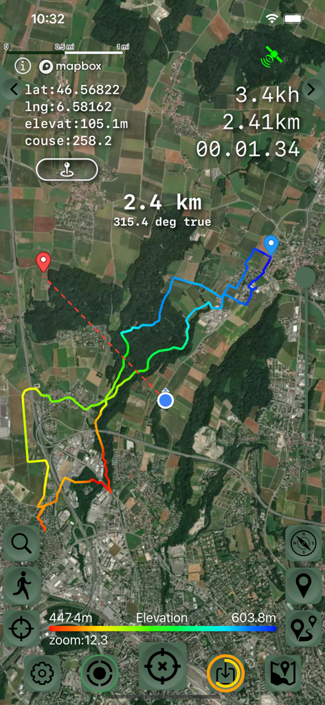
고도 변화와 내비게이션 데이터를 보여주는 색상 그라디언트가 있는 GPS 트랙의 위성 지도 보기
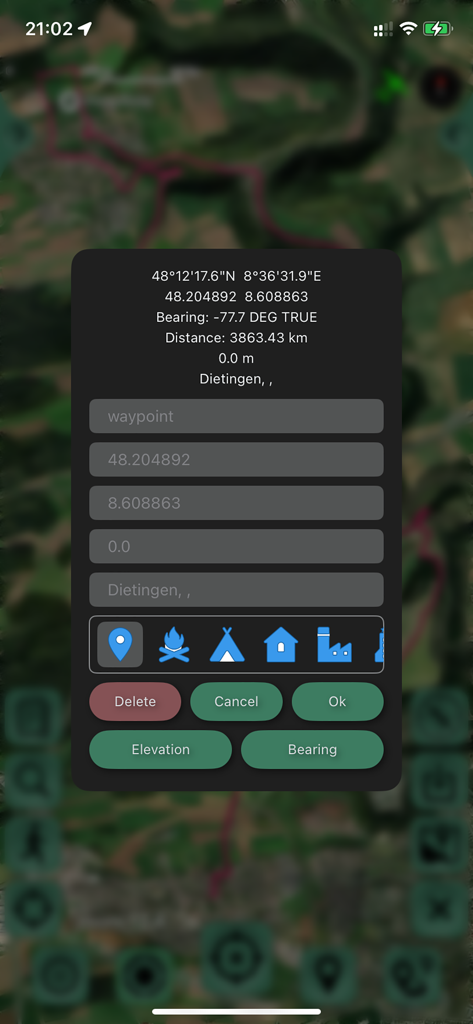
위성 지도 위의 좌표와 위치 아이콘을 보여주는 웨이포인트 편집 인터페이스
GPS Tracker 앱 인터페이스, 녹색 트랙과 내비게이션 데이터가 있는 위성 지도 표시
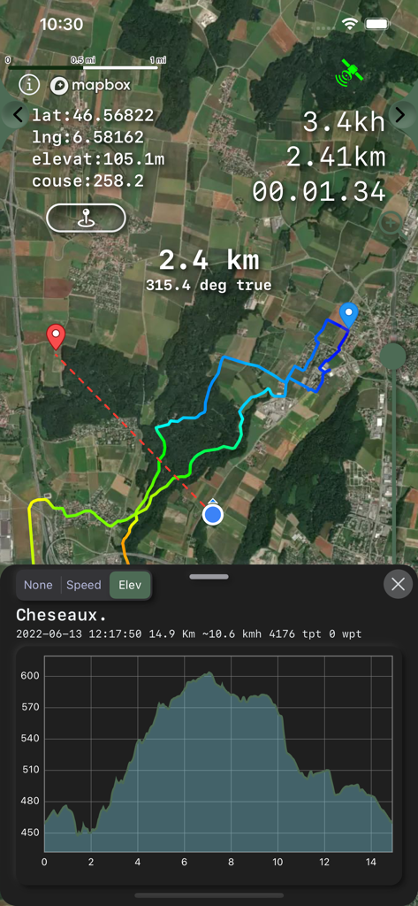
GPS 추적 앱, 위성 지도 경로와 고도 프로필 그래프 표시
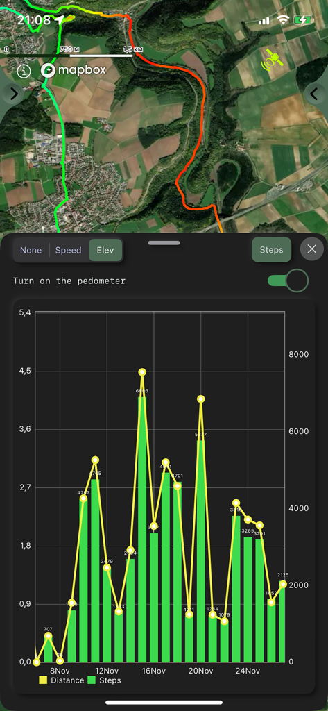
GPS 추적기 앱 인터페이스, 위성 지도와 일일 걸음 수 및 거리 통계가 있는 보수계 차트 표시
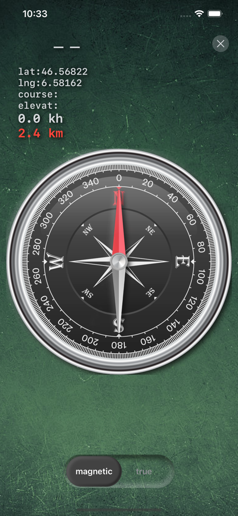
위도 및 경도 좌표를 표시하는 디지털 나침반 인터페이스
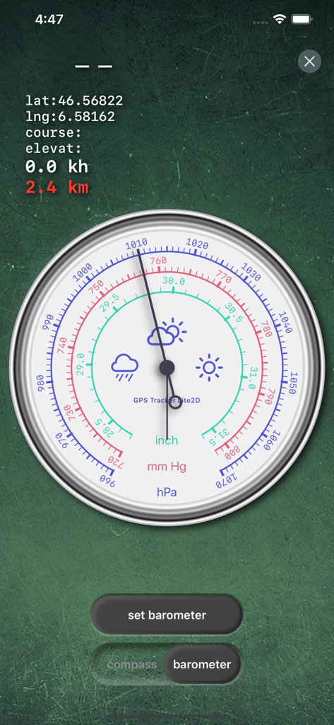
hPa, mmHg, inch 눈금이 있는 상세한 기압계 표시 GPS Tracker 앱 인터페이스
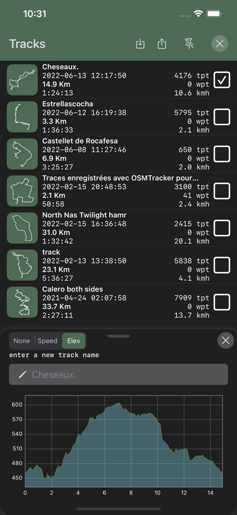
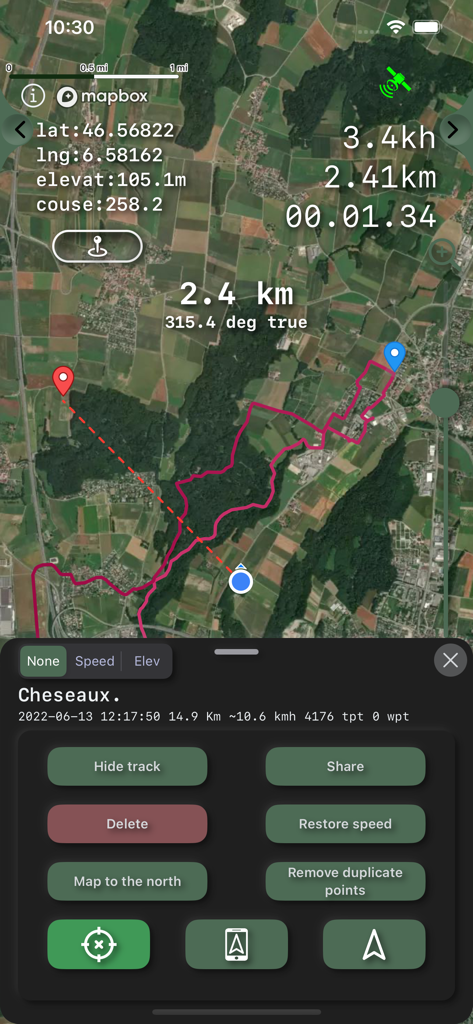
거리 및 속도 통계와 고도 프로필 그래프가 있는 기록된 GPS 트랙 목록 표시 인터페이스
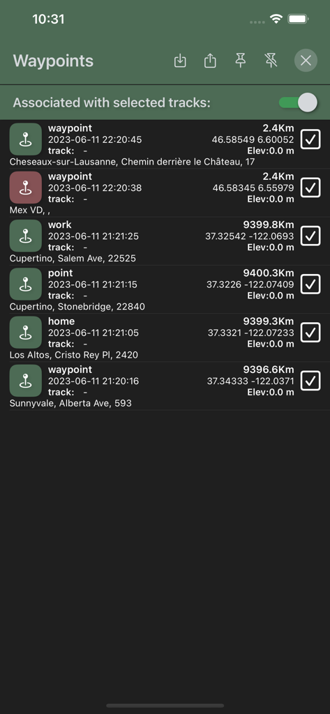
지리적 좌표, 고도 및 거리 데이터를 보여주는 GPS Tracker 앱의 저장된 웨이포인트 목록
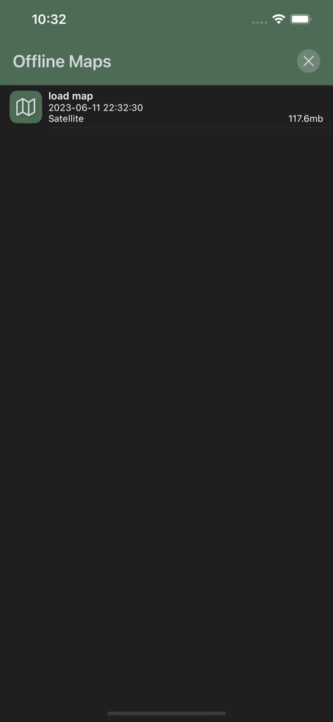
GPS Tracker 앱의 오프라인 지도 관리 화면, 파일 크기가 있는 다운로드된 위성 지도 목록 표시
설명
Download
비슷한 앱
유사한 기능과 사용자 경험을 가진 앱

AllTrails: Hike, Bike & Run
AllTrails, Inc.

Pedometer++
Cross Forward Consulting, LLC

Organic Maps: Offline Map
Organic Maps OU

Gaia GPS: Mobile Trail Maps
Trailbehind, INC.

Offline hiking maps: Mapy.com
Seznam.cz a.s.

Hiking Map Poland
Mapa Turystyczna sp. z o.o.

MapOut
Valnova GmbH

FarOut: Offline GPS Trail Maps
Atlas Guides DE, Inc.

Norgeskart
Norgeskart AS
이 페이지는 앱이나 개발자의 공식 페이지가 아니며, 정보 제공 및 논평을 목적으로 작성된 독립 편집 간행물입니다. 명시적으로 달리 언급되지 않는 한, 해당 앱이나 개발자는 MWM, Apple, Google Play, 앱 퍼블리셔 또는 앱 개발자와 제휴, 보증, 후원, 승인 또는 공식적으로 연결되어 있지 않으며, 이 페이지의 어떤 내용도 해당 앱이 MWM의 서비스를 사용하여 개발되었음을 의미하지 않습니다. 모든 상표, 로고, 스크린샷 및 기타 콘텐츠는 해당 소유자의 자산입니다.